In Search of the San Rafael Swell
Part 1 of 3
May 16 - 21, 2004
When I was restless in the midst of winter I began dreaming of a trip to
the San Rafael Swell in Utah. I had been there briefly twice before, but
knew there was a vast area I'd not explored.
Wikipedia
excerpt: The San Rafael Swell is a large geologic feature located in
south-central Utah, about 16 miles west of Green River. The San Rafael
Swell, measuring approximately 75 by 40 miles, consists of a giant
dome-shaped anticline of sandstone, shale, and limestone that was pushed
up 60–40 million years ago. Since that time, infrequent but powerful flash
floods have eroded the sedimentary rocks into numerous valleys, canyons,
gorges, mesas, buttes, and badlands. The swell is part of the Colorado
Plateau physiographic region.
I was running behind on my spring schedule. I'd only finished my shakedown
trip on May 10th and knew both that the temperatures would soon be shooting
up in Utah and that I wanted to get there and back before the week of
Memorial Day, with its crowds taking advantage of a holiday.
I talked to the local battery specialist about increasing capacity in my
battery bank and we agreed adding a third battery in parallel was the most
expeditious way to go. They had the same model as my other two in stock, so
I arranged to pick it up on Tuesday. There was no room in the battery
compartment, but as AGM batteries need no venting or special requirements I
planned to place it in the space beneath my roll-over sofa next to the
battery compartment. I'll spare you the details, but I got the battery
installed, fastened down, wired that same day. "OK," sez I, "I'll take one
day to pack-up and head out on Thursday." Being retired I have the luxury of
avoiding weekends, but this time I'd forge ahead and hope for the best,
after all the articles I'd read, and videos I'd watched, remarked how few
folks visited the Swell. Spoilers: this is no longer the case, though
nothing like the crowds at the national parks.
Click on any photo to view a larger version - highly recommended.
Thursday, May 16th
Heading Out
I didn't intend to drive all the way in one day, but would stop mid-journey to
camp the first night. I debated a couple of alternatives, but only narrowed it
down slightly before my late morning departure. I had intended to leave a bit
earlier, but didn't make it. I took my usual route out US-550, then across
Navajo lands. I had to stop for construction twice on US-64 west of Shiprock
as they are finally going to upgrade that narrow, rough highway. Hooray! I
also took my usual short-cut up from Red Mesa and then onto west UT-95 where
they are replacing at least two of the bridges, but at least by this time of
day the workers were gone, though the one-lane stretches were controlled by
traffic lights.
On the satellite maps I had noticed a couple dirt roads I'd never
driven. They are off the highway at the north end of Cedar Mesa. They might lead to possible dispersed campsites. One in particular looked interesting as it had a
side road above a small canyon. But I thought I'd check one of my very
favorite sites first in case it was available.
North Mule Canyon
I love the little site in North Mule Canyon and luck was in my favor. I'd stay
there and check out the other sites for a possible future trip tomorrow. The
creek was pretty low for so early in the season, so I guess the area had a dry
winter. The banks were well trampled by cattle, too, which was disappointing.
Still, a lovely site in a shallow sandstone canyon, ideal to get out of the
worst of the wind. The cottonwoods were green and a few wildflowers were
blooming. The birds and frogs were singing—especially the frogs!

|
|
My delightful campsite in the canyon
|
|
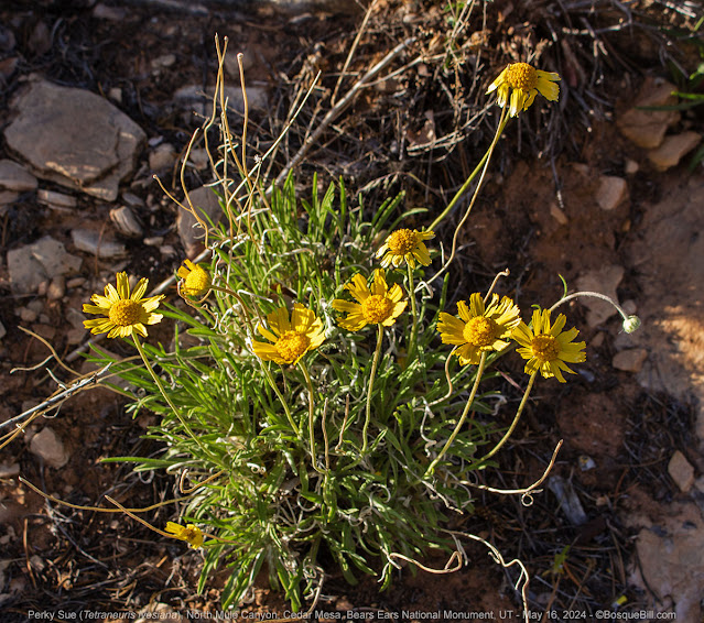
|
Perky Sue wildflowers just below the cliff
|

|
|
One of the penstemons growing right out of the cliff
|

|
|
This Rock Wren had been singing all afternoon
|
Friday, May 17th
North Mule Canyon (continued)
Before breaking camp I walked around above the canyon to photograph flowers
and/or critters. Not nearly as many flowers as on previous stays and no good
opportunities for wildlife, either. A beautiful morning even so.

|
|
Looking down on my campsite from the canyon rim
|

|
|
I loved how the long spines seemed to be almost glowing in the light
|

|
|
Not as many primroses as usual; maybe it was early in the season
|

|
|
The cacti were beginning to bloom
|
Dirt Road Exploration
I headed west on the highway and looked for the dirt road I'd spied on the
satellite map. I found the turn-off and the road was in very good condition as
it cut across Cedar Mesa. It went fairly straight through the piñon and
juniper. I found the side road that I'd spied. It was narrow and uneven, but
passible without major issues.
I came to the clearing I'd spotted on the satellite map. There were a couple of cars and several
tents already there. I'm glad I hadn't driven here last evening. I didn't see
anyone around. They were probably out exploring. There were interesting
sandstone walls in the background, maybe they were climbing.
The road got bad at that point though the map shows it continues to a spring,
but I turned around. When I got back to the "main" road I turned back west as
my satellite review indicated it would make a big curve and re-connect with
the highway. I drove less than a hundred feet when the road dipped down to
cross a small canyon feature. To my astonishment there were tall mature
Ponderosa pines and other forest greenery. A small spur led upstream where I
could see several vehicles, campers and tents under the canopy. What an
amazing campsite! I would remember this spot and hope that sometime in the
future I could find it available.
The road climbed up onto a ridge as it headed back to the highway. I passed
several places that would make nice dispersed campsites, some with views.
Another good area to keep in mind.
Highway to the Swell
Back on UT-95 I made good time west and north across the rest of the mesa,
then up along White Canyon, and on to Glen Canyon. The highway to Hite is
completely closed off now. Last year you could drive in to where the
recreational facilities and ranger station are located. All the attractions
have been closed for years, of course, as there is no lake within sight.
I stopped at Hanksville to fill up and turned north on UT-24 toward Goblin
Valley State Park. As you drive up the highway you can see the San Rafael Reef
off to the west parallel to the road. It's less than 20 miles to the junction
where I drove west, still on pavement.
San Rafael Reef
I stopped at an overlook to get a photo of the break in the reef where the
entrance to the Swell lies. My first new exploration would be to take the
Behind the Reef Road that heads south from Temple Mountain Road, the main way
in from the east. But first I stopped at one of the BLM campgrounds to air
down my tires as I knew there would be plenty of rocky roads ahead. The Temple
Mountain Townsite Campground had a nice parking area next to a vault toilet to
accomplish this task.

|
|
In the center you can see the canyon where the road crosses into the Swell |
Behind the Reef Road
The junction is very close to the campground. It is narrow and, sure enough,
very rocky in places. There seemed to be a number of dispersed camping areas
in the first mile or so. Nothing particularly special about them—homebase for
farther explorations, I guess. It was hot and windy. Everyone's tents were
flapping in the sun.

|
|
Looking toward the reef from Behind the Reef Road
|
It was a scenic road with the tall, white reef to the east as it curves up and
down and around. The lands to the west are more open. I stopped many times for
photos, but only a few looked interesting enough to post. Seems it's one of
those places that's better seen in person.

|
|
Continuing south on Behind the Reef Road |
When I was planing my trip I noted that there were two major canyon trailheads
along the road before it turned into more of an ATV trail. I thought I'd camp
at the second and explore the canyon on foot, but as the road bumped it's way
south I was having second thoughts. It was so hot and windy and there was no
cover. I came to Crack Canyon and there were two large van RVs parked. I don't
know if they were camped or not, but the occupants were up in the canyon I
assume. At this point I decided to abandon my plan and not continue on to
Chute Canyon. I'm sure the canyons are amazing, but I suspect beyond this old
man's abilities to hike, and didn't think the camping would be any more
attractive there, than here. It was still very early in the afternoon, so I
decided to turn around and proceed to my second planned destination, Hidden
Splendor and Muddy Creek.

|
|
Entrance to Crack Canyon
|
Temple Mountain Road
I turned northwest once I got back to the main road heading into the interior. I was
astonished at just how many camp trailers and RVs were at dispersed sites
along the road. The hills were thick with campers and this continued for
several miles. Some sites had nice views, but most were chosen for expedience,
I'm guessing. I also surmise that folks were just setting up a home base to
explore the Swell via ATV or Jeep. It slowly thinned out and I did see a
couple nice sites near the road with great views of Temple Mountain.

|
|
Temple Mountain and road
|
As I continued into the Swell the terrain moderated into more of a rolling
prairie. I hadn't really noted this so much before. My thought is that as the
land was pushed up the most interesting geological activity was at the
margins. I passed the cut-off that leads north to I-80.

|
|
Temple Mountain Road
|
I took the road heading southwest, McKay Flat Road, aka South Temple Junction.
Crossing one of the large flats I came across a small herd of the renowned wild
horses. I stopped well in advance as I didn't know how skittish they'd be and
took a photo of three right beside the road with my long lens. Good thing as
they ran off when the truck got close. There were six or eight grazing about
50 yards off the road to the left and they paid no attention to me as I drove
by. I suspect they are used to traffic, but don't want anyone too close.

|
|
Wild horses next to the road
|
Hidden Splendor
Just before the road bends to the northwest is the turn-off to the Hidden
Splendor Mine and Muddy Creek Wilderness. The road drops down below the mesa
and is a good, sandy road for a number of miles. There are great views off to
the east, though the clouds and haze were not ideal for photos. I spent a
little extra time processing the photo below to compensate best I could.

|
|
View easterly from the road to Hidden Splendor
|
Soon the road became rocky and rough. Nothing technical, but just slow going
over the sheets of rock, twists & turns, ups & downs. I would
recommend high clearance, though I saw that a number of passenger vehicle were
able to make it through.

|
|
First glimpse of my destination; Muddy Creek is at the foot of those red
bluffs.
|
I had come here in 2016 for a SUWA meet-up and remembered spectacular cliff
views and that I'd camped beside an old airstrip. I remembered that some of the folks who had arrived at the location before I had, set up in a much better campsite along the
edge of the bench. From there the road dropped down to Muddy Creek. When I
walked down, and subsequently up, the road it seemed it would be very
difficult for a vehicle. The group took a glorious hike down the Muddy Creek bed, but as it had been September the water was very low or below the surface for much of its length.
When I got there this time and crossed the airstrip, the bench-side site was available.
It was also just a big flat area, more parking lot than the campsite I'd
remembered. I drove to both ends of the airstrip to look for more congenial
sites. There was a prettier one at the east end of the airstrip, but there was
no way down to the river from there, so I went back to the first spot to set
up as it had creek access and I'd planned to take a walk down there in the
morning.

|
|
Camped on the bench above Muddy Creek
|

|
|
Muddy Creek; looking downstream
|
I looked down at the dugway (road dug out of the side of the bench.) It leads to the flood plain and after driving all day it looked too roug. I
didn't want to tackle it. I could see one white pickup truck parked
below, I didn't see a tent or any other signs of a camp.
I set up in the gusty winds, but at least they kept the heat from being
oppressive. I put my camp chair in the shade of my camper and enjoyed gazing
at the towering sandstone cliffs. Through the afternoon and into the evening
other cars and trucks would drive up near me to check things out. They then turned around to find other campsites. One big black truck with Utah
plates set up at the west end of the airstrip and a bit later I heard them
firing off pistols (even as late as 9pm, the jerks) I was glad they weren't
any closer. One couple looked down at the creek, then drove down to set up
their tent below. They didn't seem to have any trouble in their small SUV.

|
|
This colony of prickly pear was just beginning to bloom
|

|
|
Another view of camp featuring the tall sandstone bluffs
|
The winds let up as the sun went down. The sunset wasn't traditionally
colorful, but the light though the clouds was beautiful.

|
|
Sunset from my campsite
|
Saturday, May 18th
Hidden Splendor (continued)

|
|
My campsite on the edge of the bench
|

|
| Muddy Creek |
It was a pretty morning and after breakfast I walked around the bench. The
dugway down to the creek didn't look nearly as intimidating in the morning
after I was rested and I almost wished I'd tackled it the afternoon before. I
even considered moving camp down below. I sent up the drone to get a panorama
of the area, which turned out to be spectacular—be sure you check that out in
full-screen mode.
Direct Link
It started to warm quickly and I just wasn't feeling it here. I made the
sudden decision to bail rather than stay the day. I broke camp and headed back up the road, toward
my next planned destination, and hoped for a better campsite. On the way out I stopped
for a photo or two. I also saw a big pickup truck parked on the road headed
south. I thought it was a strange place to stop as there was no trail or
campsite around. As I got closer I noticed its left front wheel was pointed
down the road, but the right front was pointed off to the right. Ouch.
 |
| Looking back toward Hidden Splendor |
 |
| A view from the road heading out |
Reds Canyon Loop Road
Back at the junction and I turned left toward Reds Canyon (no apostrophe.) At
that point the road was still up on the flats, but as I drove along I began to
see sandstone cliffs in the distance. As I got closer I tried to identify my
destination, Tomsich Butte, but was not familiar enough with the territory to
figure it out. Now, I can easily see it in the photo below.
 |
| Heading toward Reds Canyon and Tomsich Butte |
 |
| Getting closer: see the low red butte in the middle? You'll see it again |
The road dramatically dropped down into the canyon. I took lots of photos, but
again, they are not representative of what you see when you are there. The
overhanging rocks, etc., just blend into the background. At the bottom, the
road forks—the loop continues to the right. A sign points to the left for The
Hondu (arch).
 |
| Hard to see in this flat photo, but the road is that shelf to the middle-upper left |


