
In Search of Late Season Color
October 14 and 15, 2023
This post is a continuation of my trip to Utah to experience and photograph the annular solar eclipse. Read about my time in Red Canyon and the eclipse in my previous post. Before I left, my friend Chris said that as long as I was in Utah for the eclipse I should do some "leaf peeping" on my way back. Hmmm, I suppose I could cut through the Abajo Mountains on my way home. Why not? From there I'd play it by ear.
Remember to click on any photo for a larger version.
Saturday, October 14
Cottonwood Road
As I drove toward the Abajo Mountains from Fry Canyon in the early afternoon. I decided that rather than drive up Elk Mountain Road between the Bears Ears peaks, as I customarily do, I'd continue east on UT-95 and access the Abajos via South Cottonwood Road. I'd driven down that road a few years ago and remembered there were many cottonwoods (as one might expect considering the road name) that I thought might be colorful this time of year.
As I got close to the turn-off I noticed my gas gauge. The needle was a little lower than I had anticipated. I thought I'd have enough to make it through the mountains to Monticello, but I planned to take the road through Cooley Pass I'd not driven before. The road looked twisty, so I didn't know how long it would take to drive. I reflected on my decision not to top off the tank in White Mesa. Should I drive to Blanding, fill up, and return? I did have my Rotopax gasoline containers which contained four gallons between them. I then realized that as this would be my last trip of the season, I would want to empty my gas cans before winter, anyway, in order to refill with fresh fuel in the spring. OK, that made the decision easy. No detour to fill up.
The junction with the state highway is well marked and the first stretch of road north is paved, then changes to gravel. There are many dispersed campsites in the first couple of miles under the cottonwoods. Then the road passes through land of the Ute Mountain Ute tribe and you are cautioned to stay on the road. After about 8 miles you come to the obscure turn-off to the right for South Cottonwood Road. If you discover you are climbing out of the valley and headed west, you missed the junction and are instead headed for Elk Ridge.

|
| The lower portion of S. Cottonwood Rd and a bluff of Navajo Sandstone. |
The narrow dirt road continues up the valley slowly gaining in elevation. If you look at Google Maps you will see many confusing side roads, but while driving there is never the least doubt on which is the through road.
When I'd driven down in early June of 2019 I counted 18 water crossings, many running quite full. This time there were only two or three that had any water in them at all.

|
| Larger trees are beginning to appear. Kayenta sandstone on the right. |

|
| A pocket of yellow cottonwoods ahead. |
There was some color in the cottonwoods that were beginning to turn, but not too much. The treat was higher up where I unexpectedly came across red maples amid the pines.

|
| Red maple |
|
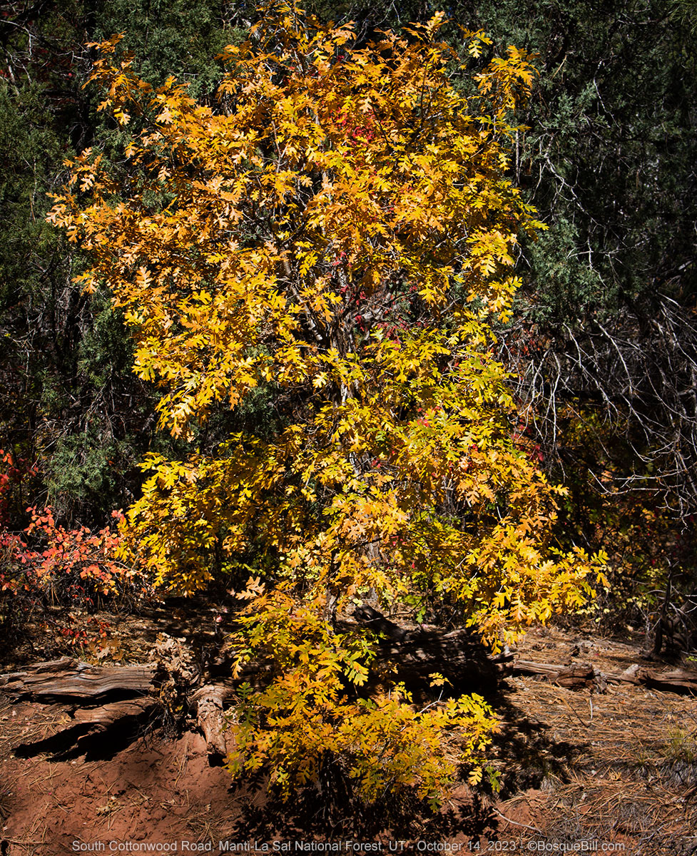
| Yellow oak |
The road climbs up out of the valley into the conifer forest. There are not many side roads through here, though I did see one that might serve for dispersed camping. Cottonwood Road then comes to a 'T' intersection with Lime Creek Road/Causeway Road. Lime Creek Road, which Google mistakenly labels Gooseberry, leads west to Elk Ridge where it joins the actual Gooseberry Road which connects to Elk Ridge Road to the south and Bridger Jack Road and UT-211 to the north. I turned right for Causeway Road and the east.
Causeway Road
In a few hundred feet you come to the intersection with North Cottonwood Road. It is theoretically possible to turn north here and make your way to the highway to Canyonlands. I've never gone nearly that far, but did find a nice campsite up that way last time. From here Causeway Road heads south at first, with a nice view west across to Elk Ridge, then wanders to the east.

|
| Looking back north at Round Mountain |

|
|
This was a small grove across the canyon on the east slope of Elk
Ridge. Image was taken with my telephoto lens. |

|
| I happened upon a few more maples in red. |
About 3 miles from the Cottonwood Road junction Causeway Road confusingly forks with no signs to indicate which way to go. I was expecting this as I'd been told by the lady at the USFS station in Monticello about it last time. She said to turn onto the south fork to see the Chippean Rocks. So this time I took the south fork and did see some large sandstone formations near the road. Either fork brings you to the same place; the north seems slightly more traveled.

|
| Looking up the hill at the navajo sandstone. |
Looking at the satellite map now, I'm not sure this was the fork she was talking about as there seems to be another loop that takes you by what Google calls the "Chippean Rocks East." Something to explore next time.
I didn't recall seeing that many dispersed campsite opportunities last time I drove through this area. I did remember stopping for lunch at the small meadow by the Vega Creek trailhead and thinking one could camp there. So I was keeping an eye out for it. I did find it and it was an RV/travel-trailer rodeo. They were really packed in there, and looking south along the opposite side road I saw more up that way. Wow, never saw so many folks up in this neck of the woods before. I kept driving.

|
| I was delighted whenever I happened upon a splash of color like this. |
It was a beautiful, sunny afternoon and I began seeing even more color—aspen and maples. After a few more miles, as I was admiring a small grove of aspen ahead I noticed a small side road off to the north. I'd look for a campsite up there. It was really just a double-track, but was relatively smooth and easy. It crossed a meadow then curved around a small ridge. Just past the ridge, at a bend, I did find a nice campsite. It had obviously been used many times over the years, but wasn't too worn and there was no trash left behind. Excellent.

|
| If you look carefully you can just see where the side road intersects Causeway Road on the left. |
I found a good spot for the camper and set up. I decided I'd walk back to Causeway Road while there was still light and photograph that small aspen grove I'd first noticed. I had a very nice walk and took lots of photos, though only a few turned out well enough to share.

|
| These twins were across from my campsite. |

|
| Looking down my little side road at the aspen grove. |

|
| Maples in among the aspen. |

|
| Laurel and Hardy |

|
| Yet another look at the aspen grove. |
I returned to camp and relaxed in my chair. It was cool enough I sat in the sun. I later learned this area is called Dry Basin. The road goes a few miles farther, but looked rougher past my campsite.

|
| My campsite |
As the sun was sinking behind the mountains I noticed a single shaft of light was illuminating a tiny patch of maple leaves amid the already dark pines. It was up the ridge so grabbed my long lens to focus in on it. Just as I snapped my first photo I noticed three deer walking across the ridge—two does and an antlered buck. I quickly took a series of photos. When the buck stopped to look down at the strange sound of my shutter I had a chance to glace at my camera and was chagrinned to see the exposure was still set for full sun. Luckily the buck's curiosity was strong enough I could change my setting and take several more exposures before he calmly walked into the trees. Very cool!

|
| The cooperative buck. |

|
| The illuminated maple leaves I first noticed. |
The temperature was dropping quickly even though I was only at 7,700' elevation. Still, I was snug in my camper that night, happy to have found this nice spot to camp and all the fall colors.
Sunday, October 15th
Causeway Road (continued)
It was a cold 25º when I got up in the morning. Brrrr! I was going to break camp early and get on the road. I would continue on Causeway Road, then at the junction near the USFS Nizhoni Campground I would turn onto Johnson Creek Road. This alpine road travels between the two major peaks in the range: Abajo Peak and West Mountain. I had tried to drive this route from Monticello south one June, but it was still closed for the season. I didn't know how long it would take to drive this new-to-me road, so my final destination was up in the air.
Causeway Road from here climbs up to a ridge that leads north to Little Dry Mesa. I stopped again to snap a view of the Navajo sandstone domes off to the west, which includes the Chippean Rocks.

|
|
It's hard to tell, but there are two sandstone ridges—the pinker one is
close; the whiter one far. Along the western horizon you can see the edge of Elk Ridge. |
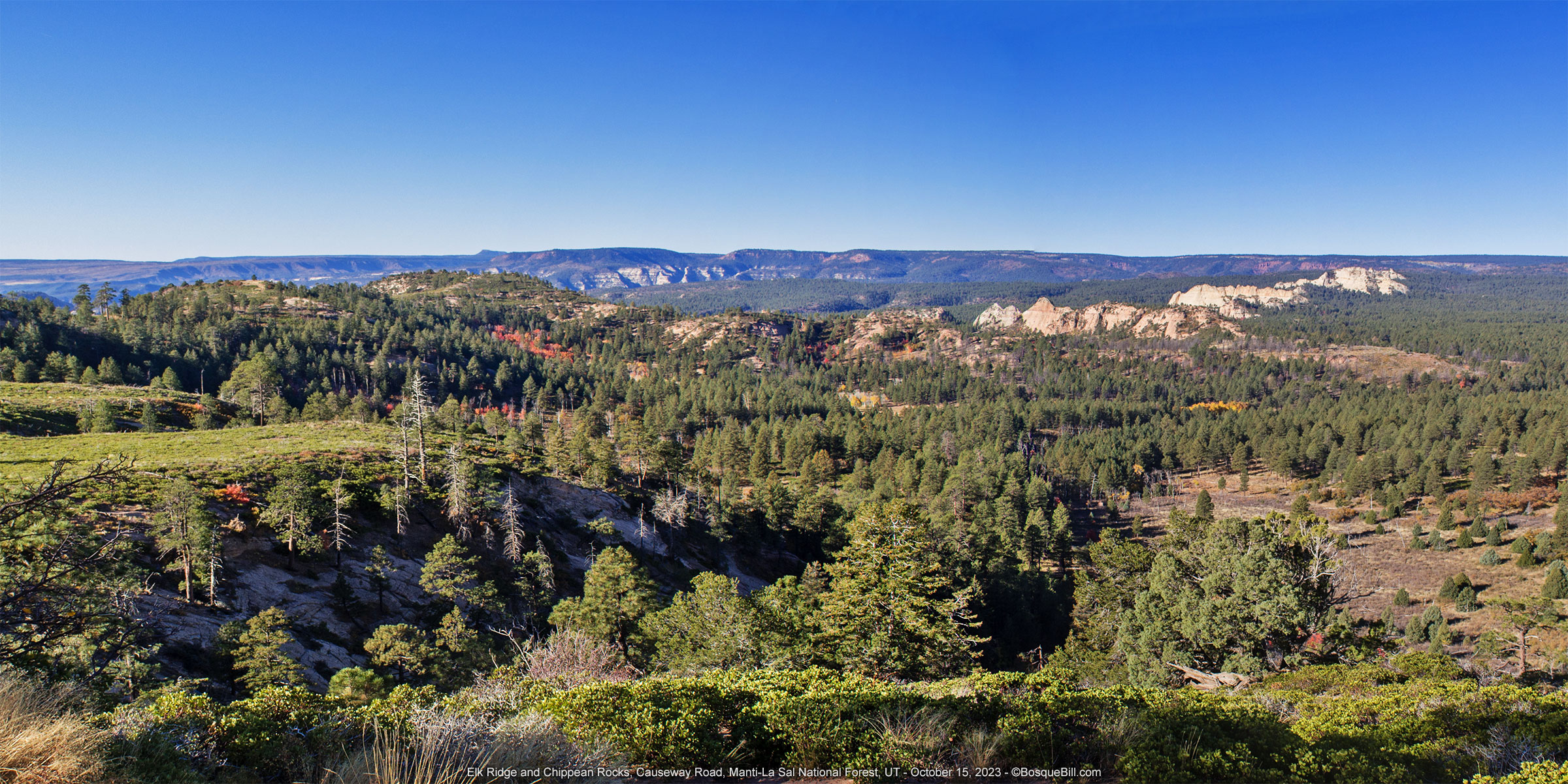
A USFS sign indicated that there was an overlook ahead. If it was the "Maverick Overlook" I'd stopped at last time, it was severely overgrown. I didn't even get out of my truck, but took two photos that stitched together nicely.
|
|
A two-image panorama from the overlook with the Chippean Rocks
stretching out to the right. You can also see the whole breadth of Elk Ridge in the background. |
When I stopped at the overlook I pulled in behind pick-up truck with small camper shell displaying New Mexico plates. I waved to my "neighbor" when I pulled out and drove on.

|
| Looking easterly toward West Mountain behind the white cliffs of The Causeway. |
The Causeway
Many maps, including the USGS topo maps, label the ridge line that runs from south of Dry Basin up to Little Dry Mesa, and across to the lower reaches of West Mountain as "The Causeway." However, the USFS has erected small signs on either end of a short built-up section of road with guardrails as "The Causeway." This second usage seems to be supported by the definition I found of a causeway: A road or path raised above the natural level of the ground by stones, earth... along the top of an embankment.
 |
| This photo (from my previous visit) shows one of the small signs designating "The Causeway." |
I crossed The Causeway and pulled off the road to walk back and take photos.
 |
| Looking toward the north and seeing the layered Shay Mountain. |
I sent up the drone for a spherical panorama since this seemed like the ideal use case. Spectacular views both north and south.
I recommend clicking the full-screen icon [ ] in the upper right or viewing the pano on Kuula.
 |
| An aerial view toward the south. |
As I drove on aspen and oaks were rampant on the slopes below the road in yellows and oranges. Even without autumn colors this is a delightful road with amazing views. Anyone who has driven in the region has noticed how prominent the Abajo Mountains are—you can see them for many, many miles away. Well, from Causeway Road you can return the favor and get a vista to the south that is breathtaking. (Sometimes it's a bit hazy.) This was a beautiful, clear day, unlike my last time, but even so the far features were obscured by the atmosphere and didn't turn out as well in my photos as I hoped.
 |
| Chippean Ridge in the middle distance is comprised of eroded Navajo sandstone. On the horizon you can see just the tops of the Bears Ears peaks on the far side of Elk Ridge. |
 |
| Gorgeous view from Causeway Road. |
 |
| Another beautiful view. |
On a particularly wide turn-out, as the road bends around a ridge allowing a great view, I came across the New Mexico truck I'd seen earlier. There was a gentleman eating his lunch, sitting on a ice chest, and admiring the view. I parked, careful not to block his view, took a few photos and struck up a conversation. This was Raul from Tularosa in southern NM who took a week off to explore this part of Utah. I tried to be helpful by giving him suggestions for some of my favorite places to visit. We also discussed books about New Mexico or written by New Mexicans. I very enjoyable break from the drive.
 |
| I think this is Mt. Linnaeus. |
Johnson Creek Road
I continued along the mountain side until I came to the junction with Johnson Creek Road where I turned left. The entrance to the developed USFS Nizhoni Campground is less than 500 yards from the junction. From there both sides of the road are clear of trees. At first I thought this was the scene of a long-ago fire, but now I'm thinking these southeast facing slopes don't receive enough moisture to support a forest.
In just less than 2 miles the road crosses Johnson Creek. At least this is what I learned looking at the map, as there is no indication of running water this time of year. There are a couple dispersed campsites both along here and farther up the road as it gains altitude and trees. I stopped a time or two for photos of the eastern slopes of West Mountain.
 |
| Looking up at West Mountain, the other major peak of the Abajos. In the upper mid-right of the photo you can see the tilted strata of the red Kayenta sandstone and "above" it, just to its right, the lighter Navajo sandstone. |
In addition to being a dramatic mountain view, this photo provides an illustration of how the Abajo Mountains, like both the La Sal Range and Henry Mountains, were formed. Magma rose roughly 20-30 million years ago, pushing up the sandstone layers and forming domes of igneous rock called laccoliths. The quartz rich laccoliths resisted erosion and comprise the tops and ridges of these mountains. I'm no geologist and my very simplified version may not be totally accurate. You might find this interactive map of Utah geology interesting. I find this fascinating.
I came upon a steep side road entering a backlit aspen grove. Rather than drive up this unknown road I pulled off, parked, and walked up the road with my camera. Actually, the road looked to be in very good condition. I later figured out this is the road to Camp Jackson Lodge & Resort, but found little information about it on line.
 |
| Looking up the side road into the heart of the aspen grove. |
 |
| The trees were backlit by the sun. Amazing color to the eye; harder to photograph. |
 |
| This beautiful, symmetrical fir was ready for Christmas with its golden aspen leaf ornaments. |
After returning to my truck I took the opportunity to have lunch. Right after this junction is a fence with cattle guard and a large sign announcing that camping is prohibited beyond this point as the land is protected as watershed for Monticello. (Though I don't understand the hydrological logic here as this area drains into Johnson Creek just like the miles of road south of here where there are many campsites.) The next camping allowed would be one of the official campgrounds on North Creek Lane outside of Monticello.
 |
| Headed toward Jackson Ridge. |
After passing Johnson Creek (I may have seen a little flowing water here) the route becomes a steep alpine road. Look for the road cut in the following photos.
 |
| Note the tremendous rock slide falling toward the center of the photo and the hill of rock at the top that I will describe below. You can see the road make a hairpin turn at that point. |
 |
| Can you see the road cut in the hillside above the aspen? |
At a hairpin turn nearly to the top of Jackson Ridge there was a sight. For one thing there was a panoramic view, for another there was a hill of broken rock on the outside of the curve. There were a couple trucks parked and I could see people up on top. Don't ask me why I didn't take a photo of that as I don't know, I should have. As many photos as I take on these trips, I seem to miss a few good ones each time.
Anyway I parked and started to clamber up the hill. It was 20 or more feet above the road surface and once I was on top I could see it fell away to the east roughly 2000'. It was an interesting experience climbing the rock pile. The rocks were irregular in shape and size, but each was mostly longer than wide and with sharp angles. When stepping on one it would slightly tilt and would ring as it hit its neighbor. It wasn't a resonate ring, but amazing even so. I'm guessing this is the remains of a plutonic intrusion that shattered into these acute cornered rocks and boulders, perhaps due to sudden cooling. But again, I'm just guessing based upon a little "dangerous" knowledge. Real geologists feel free to correct me in the comments.
The people on top were examining the terrain below with binoculars and a spotting scope. I asked what they were looking for and they replied "elk." They were pretty intent (except for the woman involved in her phone—I guess there was good cell service up here) so I didn't bug them with follow-up questions. I'll assume they were hunters seeing where the game was located.
 |
| A three exposure wide panorama of the Johnson Creek watershed. Click to enlarge. You can easily see the road traverse the slopes below South Peak. In the full-resolution photo I can see Blanding at the far right. Quite a view. |
I'd been watching the needle on my gas gauge dropping toward 'E' as I drove up the narrow, steep road and it was almost there. I decided it was time to empty my Rotopax gas carriers into my tank so I would be confident making it into Monticello. This pull-off at the top of the rock slide was a good spot for the transfer.
Continuing up the hill I crested Jackson Ridge within less than a mile. The road began a long, gentle decline that was really more of a traverse of the lower, grass covered slopes of Twin Peaks before climbing again up the slopes of Horsehead Peak. I was surprised by all the apparent terracing on the slopes. I'm guessing it's erosion control for the watershed.
 |
| Looking past the side of Twin Peaks Mountain at West Mountain. |
The road climbed a bit more and then I was over Cooley Pass. There were remnants of snow in the shade, but not attractive enough for a photo. It was only as I was working with the maps to write this post that I discovered the pass is only about 3000' horizontal feet from Abajo Peak and about 1000' lower.
From there it was a steep descent down narrow, forested North Canyon to North Creek Lane which leads directly into Monticello. Now I was back on familiar territory. I turned left (west) to see if there was autumn color in this area, but the northern exposures were long past peak. I turned around to head to town.
Monticello
I filled up the truck at the Maverik, then pulled to the side to look at my maps and decide what was next. It was only about 3pm, so I had options. When I was planning my trip I'd thought about heading up the West Dolores River into the San Juan Mountains as I'd seen lots of aspen my last time that way. At this point, however, after having driven all day that seemed like a long way to go and I'd already seen good autumn color.
I recalled that Dolores Canyon was much closer and had great scenery. That would make a great destination.
The trip will continue in the next post. Thanks for following along.


