
Moss Back Road and Radium King Road, Utah
October 12 - 14, 2023
My longtime friend Bill mentioned there was an annular eclipse coming to the Albuquerque area in October. It's not unusual for me to go camping about this time every year, so he was cautioning me that I might want to stay home and view the eclipse instead.
I had not heard of this solar event. I looked it up and discovered the center line would also cut though my favorite area of Utah. Looks like I could do a little fall camping after all!
Time to start planning an October trip. The big question in my mind was where would I go to best enjoy the eclipse? I thought Valley of the Gods would be an excellent backdrop, but knew it would be too full of people, since it is already (too) popular in the fall, much less for such an event. Then I thought about Muley Point. It was also popular, but there are campsites away from the central viewpoint that would likely be available, especially if I got there a day early. Then the chatter started up on social media by folks who were going to drive to Utah for the eclipse. Hmm, I figured I'd be better off if I selected a place that is off the radar of the usual tourists. Moss Back Road and Red Canyon, one of my favorite places, is relatively unknown. That should be a good spot.
I used the PhotoPills app to research the location with regard to the sun position. From my previous visits I knew there were tall buttes to the east of the camping area. I needed to make sure the sun would be high enough by the time of the eclipse. It would, but I'd get there a day early to get the lay of the land, just in case.
Remember to click any photo for a larger version!
Thursday, October 12th
Drive Time
I figured if I took off by 10am I'd get up to the camping area in good time. Well, it was half past by the time I got on the road after a last minute stop at Albertson's for necessities. I took my usual route, stopping for a roadside lunch on the way.
I filled the gas tank at Beclabito, as usual, cut through Arizona and up into Utah. I usually also stop in White Mesa to top off the tank so I'm as full as can be when I drive into the empty spaces. But it was later than I'd reckoned by the time I got there and the needle was barely under the "F", so I didn't stop. Would I reap the consequences later in the trip?
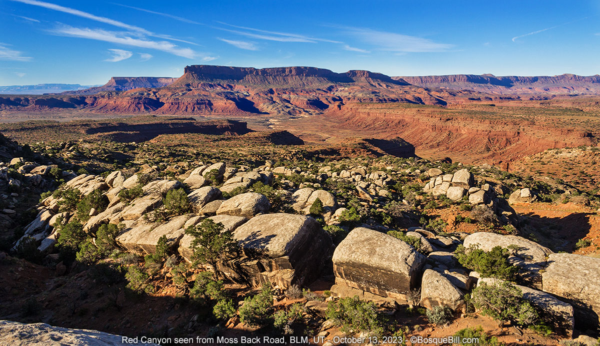
Moss Back Road and Red Canyon
I tore across the top of Cedar Mesa toward Fry Canyon, then wound my way up to the moss back formation. I passed a couple camps on my way in which was unusual, but not unprecedented. I thought I'd camp at the good spot I'd found last fall, but alas there was a group there with several jeeps, a travel trailer, and ATVs. I drove on, but didn't find a good site. I did see a pop-up camper perched on a little hill with two folks in their camp chairs enjoying the view. I waved and we tried to exchange a few words, but we were too far apart for a real conversation and I was on the hunt to find a site. I drove on, but quickly came to the end of the "good" road. I'd driven farther my first time up here and know better now.
I turned around, passed the camper and passed the group. I saw one spot that looked pretty good until I realized there was no view of the canyon, so continued on. I came upon a nice, small spot. It was great. It was right on the sandstone and fairly level. I could back up to near the rim so I could have an awesome view from my camp chair.
There was wind, but it wasn't too bad and the forecast predicted it would fall off toward evening (it didn't.) However I was fortunate that there as a large berm just upwind of my camper that deflected the worst of it. I also climbed the mound to get a good photo of my campsite.

|
| My campsite overlooking the North Fork of Red Canyon. |
The evening light was gorgeous. When I took my camera out I noticed I could only see one of the Tables of the Sun buttes from this site, unlike my previous camp sites—slightly disappointing. There wasn't much in the way of a sunset.

|
| Tables of the Sun North |
I had trouble falling asleep due to the wind, but at least the gusts were not so strong as to slam into the camper.
Friday, October 13th
Moss Back Road and Red Canyon (continued)
I woke to a calm morning with the temperature at 41º. It didn't start warming up until the sun rose over the buttes about 8:30.
|
| Those buttes in the middle background separate the North and South Forks of Red Canyon. |
As I mentioned, part of the reason to camp Thursday night was so I could see what the perspective would be at 10:30am. Yes, the sun would easily clear the buttes, but it didn't move out over the canyon as far as I'd hoped. I understood this was not important for photographing the eclipse itself, since the filter to protect the camera was too dark to capture anything other than the sun and none of the landscape would be visible. Still, I had in mind trying some sort of double exposure trickery, so walked around to see if I could find a better, nearby perspective. I couldn't. Oh, well.

|
|
Look along the edge of the moss back sandstone bench and at the far end you might see just a corner of my camper peeking around a large juniper. |
I took photos of the scenery and the few birds that presented themselves. A Rock Wren hung around for me to get a passible shot. Mostly I simply enjoyed the views.

|
| A cooperative Rock Wren |
After lunch I took a "geology walk." Yeah, not really. I took a short hike along the base of the butte behind my campsite. It was interesting and I took lots of photos of the rocks and soils that seemed very colorful and curious. Unfortunately, the photos are pretty boring for the most part. I'll only share a few.

|
| Dried plants still provided a bit of color. |

|
|
I believe this is a piece of jasper chert someone placed on top of this
sandstone boulder. I left it in place for the next wanderer to discover. |

|
| The dark rock with thin layers I believe to be bentonitic claystone which is very soft for rock. |
Please note: I believe this is my fourth time in the last couple of years to camp here on Moss Back Road. Consequently I didn't take as many photos as I did my previous times. If you are interested in this unique area and want to see more photos, please click "Moss Back Rd" here, or in the "Topics and Locations" column to the right. Thanks.
Sitting in my chair later that afternoon I got out my binoculars to look across the valley and along the bluffs. I spotted a truck and a car parked along Radium King Road across the way and wondered if they were exploring old mines on foot. There are many old mines in the area. Later that evening the truck was gone, but the car was still there. That made me curious and looking closer I discovered they had set up a small camping tent near the canyon edge. Hmmm, I bet they will have a great view of the eclipse from there—which got me to thinking.

|
|
Looking across at Wingate Mesa and Radium King Road (between mesa and
canyon.) If you look carefully just below the left of the mesa you may see a tiny circle. Remember this spot. |
A few clouds came in later. The forecast had mentioned the possibility, but also indicated they'd be gone by the time of the eclipse. They made the sunset a little more interesting this evening.

|
| Color in the sky just after sunset. |
Saturday, October 14th
Moss Back Road and Red Canyon (continued)
By the time I woke up I'd decided to move over to the area along Radium King Road, which I'd eyeballed yesterday, to take my eclipse photos. I'd break camp and drive around to to the road, perhaps a bit farther than the tent campers. I'd look for a place I could pull off the road, if possible, and with a view back across the valley.

|
| Early morning sunshine on Wingate Mesa |
Radium King Road and Solar Eclipse
I found good site off road. It didn't have the view of Red Canyon as seen from Moss Back Road, but was on the edge of a small, steep, tributary canyon. It did have a good sight lines back to the three Tables of the Sun. I walked around and found the perfect spot to set up my tripod. I had read the whole event would take about two hours, so carried my camp chair and small table to the spot, as well. I had a thermos full of hot coffee to add to my enjoyment!

|
|
Here is my eclipse watching spot with cameras and coffee.
This spot was in that tiny circle in my Wingate Mesa photo from yesterday. |
I set up my 7D with the long lens to photograph the sun while I'd use the smaller DSLR for ambient shots. By the time I got everything set the eclipse was starting. As the moon covered more and more of the sun I'd take a photo every 5 or 10 minutes. I probably should have decided on a regular interval, but guess I was too lazy.
After about half an hour I realized I was getting cold and had to walk back to my truck to get a sweater. It was amazing to me that although I could not detect a dimming of the light, it was nonetheless noticeably cooler!
Between shutter releases I walked round admiring the geology and rocks. Found some interesting erosion patterns to photograph and a few rocks to add to my collection. This was BLM land, not in the national monument, so amateur collection is allowed.

|
| The remains of mudstone cap on top of fine-grained Shinarop sandstone. |

|
|
Spherical concretions have eroded out of conglomeratic sandstone. These are not Moqui marbles as they have no iron oxide shell. |

|
| Looking up the edge of the tributary canyon eroded into the Moenkopi formation. |
I also had the idea to send my drone up to take a spherical panorama during the ring-of-fire phase. The pano is automated, so all I had to do was put it in the air and click "go." I could then return to my camera for the money shot. Which I did.

|
| Composite photo of the annular eclipse "Ring of Fire" and its phases. Time moves to the right. |
During the eclipse I used my other camera to photograph the terrain and sky. I knew it wouldn't hurt the sensor to include the sun as long as I didn't linger. This way I could put it all together in post processing.
I'm really excited at how well it turned out. I used one exposure for the foreground, one for the buttes and sky, then added the sun, scaled down, from the filtered image. The result is correctly positioned and the lens flair provides extra drama. The fact that the buttes are named Tables of the Sun adds the icing on top, so to speak!

|
| Composite photo of annular eclipse, correctly scaled and positioned. |
My drone successfully captured a panorama during maximum eclipse, but the sun was just a little too high to be within view (though I doubt it would have been able to capture the actual eclipse). Actually, I guess these spherical panoramas are really hemispherical as most of the sky is not captured. Nonetheless, it turned out to be a dandy pano and shows the North Fork of Red Canyon, Wingate Mesa, and the Tables of the Sun very well.
I recommend you either click the full-screen icon in the upper right or this link.
On the drive out I stopped along Radium King Road for photos. One to capture the colorful clays; another to show the moss back sandstone ledge upon which I was camping the nights before; and a view down into Fry Canyon.

|
| Colorful bentonitic clays below the Wingate sandstone butte. |

|
| That horizontal band between the butte and canyon is the moss back ledge where I camped. |

|
| As Radium King Road drops down the north side of the butte you can see The Needle rising from Fry Canyon. |
On the Highway
I turned east on UT-95 headed for the Abajo Mountains. After only a few miles there was a beautiful view of the Bears Ears on the far side of White Canyon of Natural Bridges.

|
| Looking across White Canyon (where Natural Bridges is found) to the Bears Ears. |
Excellent! Inspiring! I put a note in my calendar to re-read this when the the Spring "window" in Utah opens. Beautiful area! Thanks for sharing.
ReplyDeleteThanks. It is a gorgeous area. Watch out for spring winds!!! They can get especially rough on Moss Back Road as it's so exposed, much like at Muley Point.
Delete