
Part 4 of 4
Starr Springs, Cockscomb Black Table Road, Colorado River, Moss Back Road, & the Way Home
Click on a photo to see a larger version.
May 19th (continued from Part 3; go to Part 1)
Once I came out of Poison Springs Canyon I stopped just before re-entering the
highway to weigh my options. The sky, for the most part, had stayed clear, and
it was very warm, approaching hot. The Henry Mountains were a possibility even
with clouds building overhead. At this point I lamented not having better maps
of this area. Looking at my Benchmark Atlas I saw a road cutting off UT-276
several miles south of the junction with 95 and I recalled seeing a
Backcountry Byway sign there. I thought I'd try that then work my way south
looking for dispersed camping. I didn't want to try to go over the pass as
that was likely too high, too cool, and possibly under a rain cloud.
East Trachyte Ranch Road
I found the road and turned west. After a few miles I saw a couple of vehicles
that looked like campers or travelers come out which I assumed meant this was
a through road. However, before long I came to a junction not on either my map
or the GPS. I slowed to look, but passed it by. After a couple of miles the road I'd been following looked like it
terminated at a ranch. I turned around and went back to the unidentified road which was in
good condition and well traveled. After a few miles it dipped into a valley. It passed a deluxe campsite that was already occupied with camping and
horse trailers. Immediately afterwards the road dropped down to ford a creek.
It was running fast, looked deep, and was an opaque grey blue. I hesitated. I
could not see evidence that anyone else had crossed recently—both banks were
dry. I decided it would be foolish to try it, so backed out, turned around,
and headed back to the highway. Looking at satellite maps from home I believe
this was Trachyte Creek.
Starr Springs Campground
Seemed like the thing to do at this point would be to continue south on 276 and head up to Starr Springs where I'd camped once before in a nice little BLM campground. Just before entering the campground, however, I drove a bit farther to see if there was a dispersed site nearby. There's one nearby site that seems to be always occupied by two travel trailers. I tried a couple spurs beyond that, but they are no more than ATV trails with no place to camp that I could see. Consequently, I returned to the campground.
Many sites in this small, neat campground were already taken. I found a level site. It fit me well, but would be less ideal for a tent camper as the tent/table area is on a lower area reached by a short set of stairs. This was the only location on this trip where I found mosquitoes, or rather they found me. Not surprising due to the verdant nature of the campground.

Although I had neighbors, they were not around much. I finally figured out after talking to one the next morning that several sites were occupied by friends from Colorado. They were using the campground as a base for daily excursions and in the evening would gather at a site farther away from me.
Saturday May 20
Starr Springs (continued)
I walked around the campground in the morning looking for the birds I could hear and taking a few photos. I got a few glimpses of warblers and vireos, but they were too far into the bush for photos. As I drove out I stopped a couple of times to photograph the wildflowers with the mountains in the background.


Cockscomb Black Table Road
Rather than head straight back to the highway, I decided to be just a little adventurous and explore north along the gravel road below the campground. This is an interesting road running northeast along the sloped plain below Mt. Hillers.

|
| Mt. Hillers of the Henry Mountains. |

|
| The road leading me to the Cockcomb |
The view toward the east is extraordinary, although best appreciated when the atmosphere is clear and the sun in the west. This morning it was very hazy and cloudy muting the color and contrast of the red rock country. I took lots of photos, even dug out my polarizing filter, but there is simply no way to compensate for the conditions. I do want to return at the right time of day and weather to try and capture this beauty. I’m not going to post any of the bad photos of this time.
I came to a junction with a well traveled road heading northwest. This was signed as Chaffins Way. A short while later a similar junction with Rainbow Road. Cockscomb Black Table Road became much narrower and a bit rougher from this point on. If you look at a satellite image you can see that those two named roads meet about a mile up and between them are side roads and loops that might have been someones dream of a residential subdivision back when Lake Powell was a thriving recreation destination (with water levels as "intended" and a working ferry.) There appears to be one or two houses there. After returning home I phoned the Henry Mountains BLM office and they said the subdivision is on state land and that there are cabins up there and the land is considered private.

|
| Looking back at the way I came with Mt. Hillers and the Cockscomb in view. |
The road continues NE across a terrace and a hogback where a cattle guard is to be found. There were lots of wildflowers and amazing views. The road gets rougher, but not technical, as it descends crossing a few canyons before coming out at UT-276. An enjoyable alternate route and I even identified a probable dispersed campsite about 2 miles from the highway.

|
| A close-up view of a Utah Penstemon. |


|
|
The road drops off the hogback and Canyon Lands appear. The camera is not pointed into the sun so was able to salvage this photo somewhat. |

|
| I spent a long time trying to ID this wildflower without success. The serrated leaves simply do not come close to matching any flower I could find. No one on iNaturalist has suggested a species, either. |
In a "palm of hand meets forehead" moment: I was home, checking maps while writing this narrative, before I realized the large, dark, flat-topped peak I'd seen from several vantage points while driving the road was the Black Table. I almost didn't include the one photo I took. Black Table appears to be basalt rather than your typical Utah sandstone butte, not surprising considering the geology of the Henry Mountains.

Colorado River
I took UT-276 back north to UT-95 and turned east. Anyone who is familiar with this section of highway probably recalls it parallels a wash that runs all the way to the lake. I've never seen water in it, but this morning it was flowing. I guess all that rain from the east side of the Henry Mountains had to go somewhere. That, along with all the wildflowers, made this an even prettier drive than usual.
I had time so thought I'd stop and take photos of the bridge across the Colorado near Hite. Kind of a tourist thing to do, but don't think I'd stopped once in the last decade, at least. I bet many of you haven't either.

|
| Looking downstream toward Lake Powell |

|
| Hite Crossing Bridge |

|
| Looking upstream from the bridge. |
I also decided to check out Hite, which I don't think I've ever done. When I'd been poking around the internet looking for destinations and places to camp, I kept stumbling across posts praising the camping at the primitive campground there. I had thought Hite was all closed up with the lake so low, but there was only one way to find out.

|
| Highway to Hite |
Well, there were concrete barricades with pretty permanent looking "Temporarily Closed" signs just about everywhere. My determination is that it is all closed up. This is part of Glen Canyon National Recreation Area and with funding as it is, I'm guessing this area will stay closed for a while.
Fry Canyon / Moss Back Road
I hadn't placed Moss Back Road as a priority for this trip as I'd camped there twice last year. But it's a gorgeous location and fit in nicely now as a finale to my week in Utah. I pulled off onto Radium King Road, sign posted as Fry Canyon, and proceeded on the gravel road. It turns to dirt before climbing the butte, but was in very good condition. I turned onto Moss Back Road which had minor wash damage.
I returned to the site where I camped last spring. I'd camped farther in last fall, but this site I think has the most varied and beautiful views of all. I was all set up by 1pm and got in some good relaxing with intervals of walking around taking photos of wildflowers, lizards, rocks, and the views. It was partly cloudy with a mild breeze.

|
| Just look at this view across Red Canyon! |
Around 4pm I could hear thunder rumbling and clouds building behind the butte to the north. I could see rain falling across Red Canyon. It got darker and within an hour began to rain lightly, then a bit heavier. Those who also own a camper with an aluminum sheet roof know how it can amplify the sound of the rain. It sounded like a torrent outside, but it was barely wetting the rocks.


Still I had some concerns if it lasted too long and I didn't know how heavy the rain was on the other side of the butte where the road has more clay to get slippery. Nonetheless, I was well positioned here on solid rock and away from any washes.
The rain didn't last too long and I couldn't see any running water or even puddles out my windows. It remained dark and overcast. It cooled off enough that defrosting and heating up some of my homemade soup sounded attractive for the first time on this trip.

Just before 8pm I noticed there was a gap in the clouds near the western horizon and sunlight was leaking in. I grabbed my camera and scooted out the door. I started taking pictures around my camp, then realized I was going to get actual golden sunlight at an angle to illuminate the Tables of the Sun. I began walking up the road enjoying the beautiful evening taking photos every which way.


When the sun sank below the horizon I began walking back to camp and was treated to the best sunsets of the trip. What a delight.


Sunday May 21
Moss Back Road (continued)
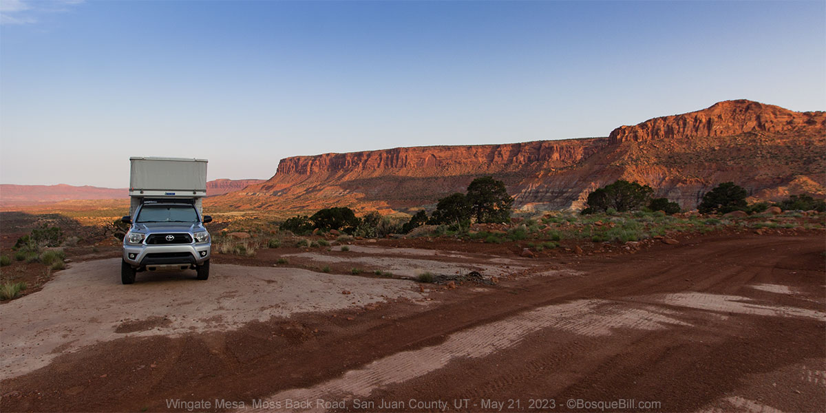

I love this campsite. Just about anywhere else being this close to the road would be a major disadvantage, but I've camped here twice without anyone ever driving by. When I camped two days at the site farther in only two vehicles slowly drove past in all that time.
I got outside just after dawn hoping to capture that wonderful light. I sent the drone up for a spherical panorama. The result is striking as the light before sunrise has brought out the diversity of this landscape of contrasting rock and soils. The spherical panorama I took last year is much prettier and you may prefer to view it.
View on the Kuula site or in the frame below, In either case, click the Full Screen icon in the upper right corner to get the full experience.
I knew I had a full day of driving ahead to get back home, but did take the time to walk the other direction along the road & cliff edge to get more photos. The Cliff Rose bushes were were showing a riot of blossoms. I've never seen such a display. I didn't realize there were so many all around. When not blooming they are just another desert scrub brush.

|
| A Cliff Rose in full bloom. |


|
| Cliff Roses on the rock bench with Wingate Mesa in the background. |

|
| A close-up photo of the Cliff Rose blossoms. |
On the Road Again
It was a lovely morning across southeastern Utah. Lots of wildflowers and views across the canyons to the mountains. I took my usual route including the Cow Canyon Road cut-off to Montezuma Creek. The Globemallows were thick on the shoulder of the road, and as there was no other traffic, I stopped for photos.

I drove south on Red Mesa Road and stopped at Tony's Road for photos of yucca blooming.

Filled my tank at Beclabito then stopped once more for a photo of yet more Globemallow, then again for a giant storm cloud.


I drove though a brief rain shower on US-550 thus completing my record of being rained on every single day of the trip (even if only briefly.) Still, a wonderful trip with mild temperatures and no bad winds—quite the accomplishment for spring. It would have been nice to have a bit more sun for photography, but you probably think I posted more photos than warranted anyhow.
Thanks for following along on my little adventure.


