Continued from
Part 1
Tuesday, October 1 (continued)
Note: If you click on a photo you can see a larger version - highly recommended.
Cinnamon Pass
I'd driven the lower section of Cinnamon Pass Road a few years ago as far as Grizzly Gulch. It is very narrow and clings to the side of a steep slope. I remembered it was very bumpy, so had aired down my tires before leaving Sherman. I also had recently mounted a new set of tires, so had sturdy rubber tread.
 |
| Barely over a mile from the Sherman junction, the road traverses a steep, narrow canyon. |
The road is alternately rocky & bumpy and smooth & flat as it passed through the "parks."
 |
| Small, colorful aspen grove next to the road. |
 |
| The road will go left of that conical rock prominence before climbing up to the pass. |
The scenery was dramatic with the surrounding alpine peaks. For the most part the road, though rough, wasn't too technical - at least until the fork to American Basin. At that point there is a sign on the pass road warning 4WD vehicles only. (As an aside, I've heard from a couple sources that American Basin is great for summer wildflowers. One fellow I talked to later in the trip recommended late July.)
I had been noticing there were long poles attached to the many steel posts delineating the edge of the road the whole length - see photo below. At one point I passed a pickup truck with the emblem of the county road department - the two man crew were the ones attaching or re-attaching those poles. I assume that's to help find the road in deep snow, though I doubt they plow this section and know they do close the road in winter.
 |
| Looking back (and ahead) after a very steep, narrow section of switchbacks. |
This next stretch of road up to the pass had some "interesting" sections - sharp switchbacks, rocky humps, and super narrow shelf roads. I met three trucks coming down, thankfully up nearer the top where there was room for them to pull over and let me by. This section is a bit "technical" and not for the faint of heart (or those with a fear of heights.)
 |
| I found the landscape to be stark and beautiful. I know the pass is named for Cinnamon Mountain due to it mineral color, but I thought it was interesting the ground cover was also cinnamon in color this autumn. |
I paused at the pass, took a few photos and tried to keep my feet in the gusty wind.
 |
| Cinnamon Pass (12,640') |
 |
| The view back from whence I came. |
 |
| The view west where I am yet to go. |
 |
| One of this group of riders was not having a good day. His bike was laying off the road. |
 |
| View back up to the pass. |
The road leading down from the pass to the west looked less challenging and that proved to be the case. Although the last mile or so before Animas Forks was unpleasantly bumpy even with low tire pressure and required me to slowly creep along. This area in the San Juans seems to have rocky roads that are no fun to drive, IMHO.
Animas Forks
 |
| Animas Forks townsite, mines, and mills. |
As I came down from the pass I stopped in the middle of road, as there was nowhere to pull off, to take a couple photos of the old mining town and surrounding structures. Animas Forks gets it name as this is where the Animas River forks into the West Fork and North Fork.
 |
| Animas Forks townsite |
I was disappointed that the light this late in the day seemed to be coming from the wrong direction for the best exposures, however. There was some wind, but I did fly a mission to try and get aerial photos of the town.
 |
| Animas Forks. Aerial photo 'shopped to minimize the back lighting. |
 |
| Another aerial photo of the townsite. |
A gentleman, and his wife, came over to talk to me about my drone. He was fascinated and I had fun talking to him about it. They live in Durango and run a travel coupon business.
I thought if I could find a camping spot not far away I'd try for photos again in the morning. Camping is not permitted in the Animas Forks area within 800' of any historic structure and that pretty much meant there was only one site in the area and it was already taken. I decided to drive up the road along the West Fork of the Animas River to look for camping. I only drove a couple miles, but could see there would be not be even anyway to pull off the awful road.
 |
| Aerial photo of the Frisco Mill structure |
On the way back down I did stop for photos at one old structure that Google Map labels Frisco Mill at Bagley Tunnel. I was able to get on its west side where there was still good light. Most of the mines in the Silverton area are tunnel mines, there are a few exceptions such as Yankee Girl that have vertical shafts.
 |
| Frisco Mill structure |
I abandoned my effort to find camping anywhere near Animas Forks and started down the road toward Silverton hoping to find a camp site farther down. Little more than a mile down from Animas Forks there was the remnant of the avalanche that had blocked the road until August. Though they managed to carve a path for the road, it is still about 15' at the tallest point and about 40' wide.
 |
| Road to Silverton |
 |
| A more modern mine across the canyon seen on the drive down. |
I stopped briefly at Eureka Gulch to check out the campground there. It's a private facility that is closed for the season. I talked to a group of men who'd been camping there and they said it was open to the public for free camping at this point. There was a lot of downed timber and the wind was whipping down the canyon. I found one mostly sheltered spot, but there were lots of flies. So I continued down the road.
Minnie Gulch
A little more than a mile farther down I spotted a forest service road with a sign, Minnie Gulch. I drove up the road as it climbed up a few switchbacks then along a steep slope. It crossed a small creek about a mile along and then I saw mine ruins on the left and an old building next to the road. About a quarter mile farther I saw a short spur where I could pull a ways off the road. It was close to level and there was a fire ring, so had been used as a campsite before. As it was getting late, close to 6pm, I set up there. It was next to tall trees that sheltered me from the wind, another plus.
 |
| My campsite. Photo was taken the next morning when there was better light. |
Turned out to be a nice, impromptu site, and though close to the road, no one came by the whole time I was there. The creek happily bubbled and babbled through the night, keeping me company.
Wednesday, Oct 2
Minnie Gulch (continued)
At some point from the last evening to this morning I decided to change my plans. While at home I'd created an itinerary though the mining district high above Silverton, but two things were on my mind. First, the fall colors were bursting out with abandon which is a short lived event; and second, I was already tired of being jolted by the rocky roads on these mountains. I would head down to Silverton, check South Mineral Creek Road to see if there were autumn colors that way, then head over to Ouray on the way up to Delta and the back road to Kebler Pass Road east of Crested Butte. A total gamble regarding the timing, but I knew there were miles of aspen groves along there. OK, new plan in place.
 |
| Aerial view of my campsite |
My map showed a mine site farther up the road, but I'd have to climb a ways to get there and had no information if it was a cool site or not. So after I let it warm up a bit, I took some photos from the ground and air.
 |
| Aerial view down the canyon |
I headed back down pausing at the mine ruins just below.
 |
| I'm thinking this was a miners dormitory for the mine just below. |
 |
| Mill foundation located just below the photo above. |
 |
| It was a beautiful drive down the gulch this brilliant morning. |
 |
| Just before descending the switchback I found this view, looking down toward Siverton. |
Eureka Gulch
The Eureka site was only a mile back up the road so I headed that way first. The buildings of the Sunnyside Mill are long gone, but it has an extensive foundation that stair-steps up the mountain side. Seemed like an opportunity for someone with a flying camera.
 |
| Sunnyside Mill |
 |
| Aerial photo of mill foundation |
I then drove down to Silverton where I stopped at the grocery store and bought a deli sandwich to take with me.
South Mineral Creek
I didn't drive all the way to the end of the gravel road. There were groves of aspen on the north side, but not the south. I took some aerial photos and video from a couple of places.
 |
| Aerial panorama looking up the canyon |
 |
| Aerial panorama looking down the canyon toward Silverton |
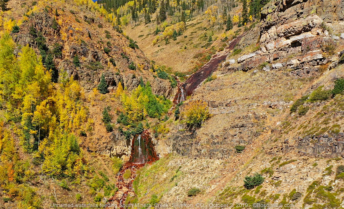
I also discovered waterfalls I didn't know existed. They're on a small stream that feeds into South Mineral Creek. They're located on the north side of the road. I flew over to them to capture the detail below. (If you expand the image above, you can see them in situ near the left edge of the photo.)
 |
| Waterfalls on the north side of the canyon. |
Million Dollar Highway
Before leaving South Mineral Road I refilled my tires with highway pressure. The drive to Ouray was beautiful. Not all the aspen had turned, but the colors combined with the natural minerals of Red Mountain created a lovely palette.
 |
| View of Red Mountain from US-550 between Silverton and Ouray. |
Journey continues in Part 3.