
Showing posts with label Lost Lake. Show all posts

Sunday, November 10, 2019

Colorado Autumn - October 2019; Part 3

Continued from Part 2

Note: If you click on a photo you can see a larger version - highly recommended.

Wednesday, October 2 (continued)


I drove straight north though Ridgway and Montrose. I stopped for gas in Delta where I took CO-92 to the east. The highway passes to the south of Grand Mesa and I could see yellow aspen high on its flanks. I took the left fork for CO-133 at Hotchkiss. The turn-off to Kebler Pass Road (County 12) is just before Paonia State Park, not to be confused with Paonia River Park. The junction was poorly marked and I almost missed it.

Kebler Pass Road


Though I'd driven by it a number of times, I just noticed the Erickson Springs Campground at the sharp bend before the road begins to climb. I didn't stop, but it looks like a pretty, small USFS site with great views situated right on Anthracite Creek.

Ragged Mountain was beautiful with its skirts of autumn color.
This photo was taken from the road only a short way up the mountain side.

Another view of Ragged Mountain, and of Ragged Peak (to the left.)
This photo was taken from the overlook where the road reaches the top.

It was nearly 4:30 by the time I started climbing the road into the Elk Range and Gunnison National Forest. The views were gorgeous and I stopped many times for photos. The oaks were already brown, but the aspen groves ranged from 30% to 60% golden.

There were great vistas to the south of the road of the Beckwith Mountains.

Farther east along the road, Marcella Mountain shines on the north side of the road.

Lost Lake


I took the side road, FS-706, toward Lost Lake. If I remembered my previous visit, the sun would be behind the mountain on the far side of the lake, so the light might be poor for photos, but I wanted to look. There's a small campground at the lake and if I could get a good spot I'd camp there and be ready for the morning sun on the lake and surrounding peaks.

The road to Lost Lake

As I drove up I took note of many dispersed campsites along the road. Some were right next to the road and would be very dusty, but others were farther back. If there was no room at the campground, or I didn't find a site I liked, I would return to one of these.

As I expected the sun was behind the mountain, but there were aspen in the sun and their reflections in the lake.

Lost Lake

There was one site available in the campground, a pull-through right next to the road. It was not to my liking so I drove out and back down the road. I found a great site well off the road in a thick grove of spruce. But the trees were so densely packed that they blocked off the satellite radio signal. I couldn't camp there and listen to the baseball playoff game that night, so continued back down the road.

The road leading away from Lost Lake

It was almost 7pm by the time I found a more compatible site and got set up. I missed the first couple of innings, but the site was quite nice and far enough from the road to be out of the dust.

My campsite along Lost Lake Road.

Colorful leaves next to my campsite

Thursday, October 3


Wow, it was extremely cold in the morning, 17ºF as I recall, so I wasn't eager to get out. I read a bit and drank coffee until it at least got above freezing. I broke camp and headed back toward the lake at about 10am.

Lost Lake


The sun was shining on the Beckwith Mountains and I got a pretty photo. The wind had already disturbed the surface of the lake, so no reflections.

Lost Lake with the Beckwith Mountains in the background.

Kebler Pass Road


I drove back to the main road and headed east. I stopped several times for photos, both from the ground and from the air. There were quite a few cars and trucks on the road with lots of folks also stopping for pictures of the colorful foliage.

Aspen grove

East Beckwith Mountain

Even just looking at the view from the UAV camera on the phone screen showed amazing vistas and when home and on the big computer screen they were amazing. I especially like those that show the uneven terrain and Ruby Anthracite Creek.
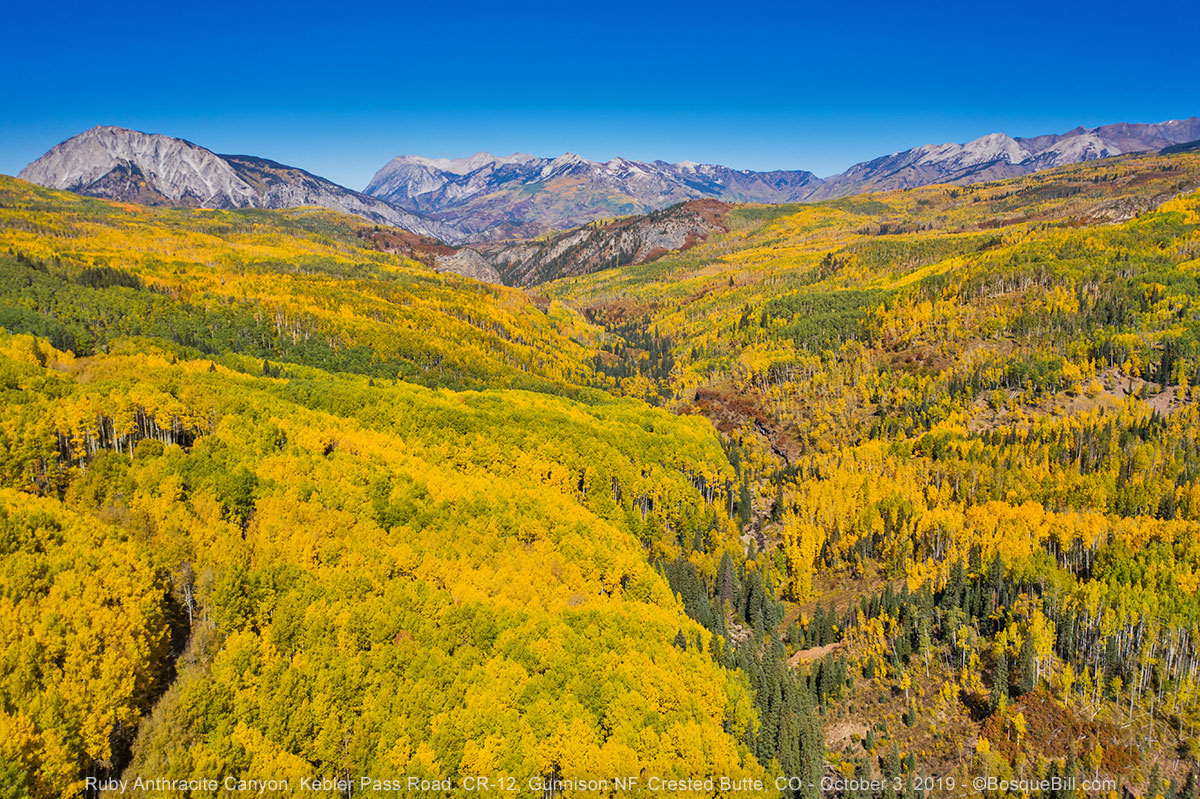
Ruby Anthracite Creek valley

At one point I pulled off into a large aspen grove. I was hoping to find the spot I camped several years ago and get some aerial images from there.

Looking down into an aspen grove

Ruby Peak as seen from Kebler Pass Road

Striking red foliage below a rocky ridge of Ruby Peak

I took spherical panoramas from a couple of locations, but have only posted this one.


I stopped for a picnic lunch at Horse Ranch Park where there were a number of 5th wheels and travel trailers camping. This was also a popular place for photography due to the view from near Ruby Anthracite Creek. After a few more photos and a short flight, I continued east.

East Beckwith Mountain

Ruby Peak from above Horse Ranch Park

There are a few nice views from a couple miles east of Horse Ranch Park, but go much farther and you get out of the aspen groves. Should I double back or go on? In years past I remembered wonderful aspen in Gothic Valley north of Crested Butte, maybe I should check out that area. Also, though the skies remained clear, the forecast was for clouds and rain the next day. Perhaps it would be better to head toward Taylor Park so I could escape over Cottonwood Pass, that was now paved, if the weather turned bad. It was a straight shot from there toward home. Besides, I felt I'd gotten great photos of all the major areas along Kebler Pass Road. Onward and upward!

Crested Butte and Gothic Valley


Crested Butte: mountain and town

So I kept going east to Crested Butte, then drove north though the resort village of Mount Crested Butte to Gothic Valley. Once in the valley it didn't take long to realize the aspen were well past prime in this area. I drove past the research station hoping there might be good color farther up, but stopped after crossing the creek. There was a little color there so took a few photos for good measure, then turned around and headed south.

White Rock Mountain and the East River in Gothic Valley
I'd seen a colorful mountainside on my drive north, so turned onto Washington Gulch Road to get a photo.

Washington Gulch


Journey continues in Part 4.


Monday, October 27, 2014

In Search of Autumn Color: Colorado

A Narrative in 3 Parts

Colorado, October 2 – 9, 2014


My plan was to head up to SW Colorado on the last Monday in September to look for colorful, fall aspen leaves, but the weather forecast was not good, so I delayed leaving until Thursday.
This turned out to be an excellent decision, as the skies were clear when I arrived in Colorado and there was still photogenic snow at the higher elevations (and some mud and slush, too.) I enjoyed great weather most of the trip, though it got cold at night.

I took lots of photos during this trip, so thought breaking up the narrative and images into three parts made sense for you and for me.

Remember to click on a photo to open them all at a larger size in a viewer window.


Here's my route for the full week, very roughly clockwise in travel - follow the red arrows and colorful legend.

Part 1: October 2nd to the 4th


The first part of my journey took me up though the San Juan Mountains to Owl Creek Pass. From there I headed northwest, passing though Gunnison, to follow a county road along Ohio Creek up to Kebler Pass Road.

Thursday, October 2nd


As I headed northwest through New Mexico, the truck experienced some head winds left over from the storm passing, but luckily they died down after about an hour. I stopped for lunch at Zia Tacqueria in Durango. As I mentioned in earlier blog posts, my neighbors had raved about their fish tacos, which I had indeed found to be delicious. This time I thought I'd try their green chile pork - yummy!

There was some autumn color as I drove into the San Juan Mountains. My destination was Owl Creek Pass. My buddy, Chris, had strongly recommended the area for autumn color. He had shown me his beautiful photos with Chimney Rock, and other interesting formations, as backdrop. As I drove through Silverton I saw that the aspen were far past peak, so I didn't bother checking up Mineral Creek, but continued on.

Approaching Engineer Mountain on US-550. Autumn color is beginning to show.

Owl Creek Pass


I passed through Ouray and Ridgway to turn east on Owl Creek Pass Road on a beautiful, late fall afternoon. I could see Chimney Rock way off to the east. After driving up a wide valley, the route began to climb into the mountains and the road changed from dry & dusty to rocky, and then muddy with patches of snow in those areas that receive lots of shade.

Chimney Rock

Many of the aspen groves were gone by, brown or even leafless, but most were others still green or shifting into yellow. I stopped to take pictures from time to time. The late afternoon light was lovely on Chimney Rock. I drove over the pass and down the other side with the intention of finding a dispersed campsite.

Cold, snowy Owl Creek Pass

I skipped the first road just below the pass, FR-860, as it was too snow covered. This eastern side of the mountain seemed to have more snow, though there were clear stretches, too. As I drove down the mountain I could see colorful aspen west across the valley, but as they were in the shade, I decided to come back this way in the morning.

I checked out one campsite just before the Cimarron River. It was ok, not too muddy, but cold and uninviting. I passed Middle Fork Road, then turned up the East Fork Road. There were folks camped along there and those sites unoccupied were muddy or snow covered. When the road climbed away from the river, I backtracked to Middle Fork Rd. The first site was taken, but the second was not only open, but level and scenic, alongside the river. It was a little muddy, but the ground was at least firm. I set up in the last light of the day with rapidly falling temperatures. (I need to come up with a better mud control protocol for setting up to keep the floor of the camper dry and clean. Perhaps a plastic carpet runner cut to size would do the trick.)

My campsite along the Middle Fork of the Cimarron River with the last rays of sun on the peaks.

Friday, October 3rd


My campsite in the frosty morning

I took a short walk around the area where I'd camped, though the temperature was still cold. It had gotten down to 27º overnight. It was a nice area and there were a couple of other large dispersed sites just a little farther up the road. After my walk, I drove to the end of Middle Fork Road where there is a trailhead. There was one side road to explore another time, but no other campsites. I turned around at the trailhead.

I then drove back up Owl Creek Pass Road to look at the areas I'd seen the evening before. Such a beautiful area. I also saw the same unpredictable mix of green, yellow, brown and bare aspen groves, many times right next to each other.

FR-860 near Owl Creek Pass

I drove up the road just below the pass in hopes of photographing Chimney Rock from the "morning" side with aspen in the foreground. There were no aspen up this road. I did, however, see my very first moose in the flesh and tried to get a picture as he disappeared into the trees. I turned around where the road goes from unimproved to 4WD only. It was very rocky and my goal this trip was for autumn color, not rough roads.

My very first moose sighting, somewhat out of focus. I was delighted to see this guy!

I took another look at the pass itself, then drove back down. I took a number of photos in the area where FR-858, 861 and 863 converge south of Silver Jack reservoir, though those roads may be numbered differently on different maps. There are many dispersed campsites in these areas.

Owl Creek Pass Road down near the Cimarron River

I then headed north on 858, a.k.a, Big Cimarron Road, named after the river.

At the junction of Owl Creek Pass Road and East Fork Road

Roadside glory

The reservoir and campground was closed, but there were some pretty aspen by the closed, Beaver Lake campground with a little pond farther north - and a gaggle of photographers.

Pond next to Beaver Lake Campground

Such a beautiful scene. I had to include another view.

I decided to continue north along Big Cimarron Road to US-50 rather than staying in the area. As I drove down the road, I passed a number of trucks pulling long, trailers. I bet they were headed for those wide, flat campsites I'd just vacated. Big Cimarron campground was still open, but then the national forest ended in private land.

Ohio Pass


Ranch country along Ohio Creek Road on the way to Ohio Pass in the Anthracite Range.

On reaching US-50, I drove east to Gunnison, then turned north on CO-135. Just a few miles north of town is Ohio Pass Road, to the left, which goes through quite a bit of ranch country, then climbs toward Kebler Pass Road. There were a few photo opportunities along there.

Looking southwest at the West Elk Mountains from near Ohio Pass.

Once I got to Kebler Pass Road, County 12, I took a look at Lake Irwin campground, which I'd missed my last time by here as the road is unmarked. This time I was forewarned, examined the map carefully and found it. A nice forest campground with a pretty lake, but I had aspen on my mind, so moved on.

Lake Irwin, with the campground overlooking the lake. Photo taken crossing the small dam.

Kebler Pass


I headed west, over Kebler Pass, on CO-12. There were a few aspen photo opps and lots of people admiring them. I checked a couple dispersed camping areas, but they were well populated. I didn't want to go too far as I figured the light would be better in the morning for the area I was traveling through. Then I spotted a little, muddy track into an aspen grove with a nice campsite. I set up there in the late afternoon and walked around taking pictures while the light lasted. Luckily the ground in the grove itself wasn't too muddy. It was covered with aspen leaves of all colors.

My campsite in an aspen grove, not far from Anthracite Creek.

A photo using my 300mm lens showing an outcrop of The Dike formation.

Ruby Peak as seen though my 100mm lens.

Saturday, October 4th


I backtracked a few miles to photograph one of the scenes I'd passed last evening.

Anthracite Creek with Ohio Peak in the background.

I continued west on Kebler Pass Road. I enjoyed the scenery much more than my last time when it had been raining and overcast. I took the spur, FR-706, to Lost Lake Campground. I'd hadn't explored that way last time. Another small, pretty campground with a dramatic view of high mountain peaks reflected in the lake. I had a nice chat with a fellow in a VW Westfalia. There were a couple of dispersed sites along the road to the lake close to the main road.

Lost Lake on a glorious morning.

Continuing west on CO-12 there were some spectacular vistas looking across the patchwork color laid upon Snowshoe Mesa with snow covered mountains in the distance. As beautiful as this was to view in person, the photographs were too pedestrian to include here. Hwy 12 drops elevation here and runs along Anthracite Creek (which I later figured out, was the same water as I'd photographed earlier) until it and the creek reach the North Fork of the Gunnison River at CO-133.

The journey continues in the next installment.