Showing posts with label Rio San Antonio. Show all posts

Sunday, July 13, 2014

Northern New Mexico (NM/CO) - June 2014


New Mexico and Colorado - June 2014


I'm breaking this trip into two blog posts, which is not unusual. However, instead of doing this strictly chronologically, I will divide the posts into a New Mexico post (Monday, Tuesday, Wednesday morning, Thursday afternoon and Friday), then a Colorado post (Wednesday noon to Thursday afternoon).

Remember: to see larger versions of the photos, simply click on one.

Monday, June 23, 2914


Jemez Mountains


I started out this trip by revising favorite areas in these mountains only about an hour NW of home. I intended to search out the small rivers and streams for dragonflies. For some reason all the fishing access spots along the lower Jemez River were closed.

Jemez River

 I stopped on the shoulder of NM-4 where it was close to the river. There was no dragonfly activity, but I did photograph this lizard.

Whiptail Lizard next to the Jemez River

I turned back to the NM-485 turn off that leads to FR-376. I always enjoy the scenery where the Gilman Tunnels punch through the narrow canyon of the Rio Guadalupe before it flows into the Jemez River.

Gilman Tunnels

I stopped at my favorite place to access the stream just past the tunnels. Very little activity there, though I did see a Four-spotted Skimmer dragonfly that is usually only seen on lakes and ponds. I'll post a photo of this species later in this narrative. I also was happy to find a Red Rock Skimmer, a species I'd been looking for in the Jemez for two years, though other people didn't seem to have any problems finding them.

Red Rock Skimmer

I then drove up FR-539 that runs along the Rio de las Vacas. The stream at my second favorite stop was lower in June than it had been last year in August - not a good sign for the forest. Very little wildlife activity there, either, though I photographed a pretty butterfly and a very blue damselfly.

Weidemeyer's Admiral Butterfly

Tule Bluet Damselfly

I decided to continue up 539 as I'd never driven past that one spot before. My poor reading of the map led me to believe it connected to FR-126. Physically it does, but where it passes through private land the gate is locked. I returned to 376 and continued north. I took FR-604 which branches off 539 about a mile before it hits NM-126. I'd wanted to explore up this way as the USFS map showed it led to Ghost Rocks above La Cueva. I'd explored these rocks where I was a kid. The road does indeed lead there, but to the top of that feature, so there is no way to explore the rocks from there, but I did take pictures. I should have realized the rocks were on private land, but was still disappointed to discover someone had built a cabin just below them.

Looking down at Ghost Rocks

I then took NM-126 west past the turn to Fenton Lake to the Fish Hatchery. I'd found interesting dragonflies here before, but only saw the Four-spotted Skimmer and lots of damselflies. I did also get a nice shot of a Song Sparrow.

Four-spotted Skimmer

Song Sparrow

Continuing on NM-126 I ran into a couple miles of white dust of the consistency of talcum powder. It was so deep that I shifted into FWD just for stability as it was actually slippery! This was surprising as the road was perfectly fine last August. I guess it really is dry this year (glad to report the Jemez has received a couple of good rains in early July since my trip.) I then hit a delay for road construction. I was going to stop to check for dragonflies where Rio de las Vacas crossed 126, but that clearing is just where the construction company was parking their heavy equipment. Sigh.

I continued on the the town of Cuba. I stopped there at El Bruno's for either a late lunch or early dinner and had one of the best green chile cheese burgers, evar ;-) With the large portion of fries, I couldn't finish it so took half along for later. Gotta love having a fridge in the camper. (Spoiler: it was better cold that most other burgers are, hot.)

Just northwest of Cuba I took NM-96 north, then east, to connect to north US-84 and hence to US-64.

Tres Pedras


I'd never been on 64 between 84 and 285 before. It is a lovely area, but all of it until well after you go over the pass is private. There was a spectacular rock mountain to the north which I learned is named the Brazos Cliffs. I stopped at the overlook just past the pass to try to get a photo. The light wasn't very good and I waited a while to see if the clouds would change and sun would shine on the cliffs, but it never happened.

Brazos Cliffs


Once I entered Carson National Forest I turned off to try to find dispersed camping, but the forest road on the map was closed. I tried a smaller road on the other side which was a bit rough. I found a couple of potential spots, but the mosquitoes were thick. I did get this interesting photo of a lone pronghorn shedding it's winter coat.

Pronghorn in molt

As there was no immediate prospect for bug-free dispersed camping and it was getting late, I turned into the National Forest campground at Hopewell Lake. As in most areas I've noticed that older forest camps have become day-use only and new camping areas have been built to be more ecologically sustainable and physically larger to accomodate the trend toward larger camp trailers and vehicles. Such was the case at Hopewell Lake where camping is no longer permitted at the scenic lakeside sites. The new campground had the advantage, at least, of being mosquito free.

I didn't realize until the following day, many miles away, that this was the first campsite I've utilized in my FWC camper where I forgot to take a photo of my camper in the site. Perhaps because of my late arrival. Oh, well, it was bound to happen and this was a pretty ordinary site, after all.

Tuesday, June 24


After breakfast I took the trail from my campsite down the hill to Hopewell Lake. It's a nice looking lake and I had fun chatting with the folks fishing and the family cooking breakfast lakeside. There were wildflowers to admire, as well.

Blue Flax

The north end of Hopewell Lake

I spoke with the fisherman who had the blue, inflatable pontoon boat in the photo below; he said there were enormous trout, some even 24" in length out in the middle of the lake. Of course that could be a fish story.

The south end of Hopewell Lake.

Blossoms of the shrub that was all around the lake.

After returning to camp and packing up I kept on 64 with the goal of heading north on US-285 and then west on FR-87, an interesting road I traveled last year. I had asked the camp host about FR-133 that heads north from 64 up to the same area, but her description of the roughness of the road convinced me to take the pavement around.

Taos Plateau


I love driving west on FR-87. The first 15 miles, or so, are the northwest-most part of the Taos Plateau Volcanic Field.  It is the largest volcanic field within the Rio Grande rift, but you wouldn't necessarily realize that looking at the grass and shrub covered praire. The first 5 miles are BLM, then you enter Carson NF. Incidentally, the largest section of the field, east of US-285 is now part of the Rio Grande del Norte National Monument, established in March 2013 which runs from the Colorado border to just north of US-64.

San Antonio Mountain looks like a small, round hill, but is a volcano with a height of 10,908 feet.

San Antonio Mountain from FR-87 near US-285

I stopped where 87 crosses Rio San Antonio creek to look for dragonflies. I only saw a few damselflies and some lovely wildflowers, but it is a pretty stream.

Where 87 crosses the Rio San Antonio.

Toad Flax on the side of the cut above the Rio San Antonio


Rio San Antonio

Boreal Bluet on the Rio San Antonio

Tusas Mountains


I continued up 87. It quickly climbs up into the foothills of the Tusas Mountains leaving the plateau behind. There are gorgeous views from up here.

Looking back (east) toward San Antonio Mountain and the plateau.

Paintbrush near my feet where I took the photo just above this one.

At the "top" of 87 you can go left, continuing on 87 to Lagunitas or right, following 87A, to Rio de los Piños. Last year I went right, this year I wanted to look at Lagunitas to see if the campground was worth spending the night, then head back the way I did last year. There was some pretty country on 87 and some rough road, too.

Looking over the Cruces Basin Wilderness from the junction of 87 and 87A

Olguin Mesa seen from FR-87

The campgrounds at the lakes at Lagunitas are of the old style, though it looks like they are trying to refurbish the lower campground. Seems they brought down quite a number of full grown trees, but then stopped without taking them away or doing anything else to the sites.

Lower Lagunitas Campground and one of the little lakes.

Strange and it didn't make it inviting for me to stay, so I headed back, then continued on on 87A.

Golden Banner growing alongside the road.
I simply poked my camera out my window.

Last year when I camped at Rio de los Piños, it was just me and one couple way down the road. This year there were folks in nearly every site. That doesn't make it "crowded" like most campgrounds as most sites are placed along the road at far enough intervals that you are out of eyesight and hearing of other campers. I didn't get as pretty of a site this year, but did find one with lots of shade for the very warm afternoon.

My campsite next to the river.

It is a beautiful area with the river running along rocky cliffs. I enjoyed my early evening walk and took a few photos.

River and canyon walls

Wild Rose

Bend in the river

Spotted Sandpiper

FR-284 runs along side the river

Wednesday morning


After a short morning walk, I left the campground on Los Piños Road that leads north to Colorado.

The next section of my trip in Colorado will be covered in the next post.


Thursday, continued.


I returned to New Mexico from Colorado on a hot Interstate-25 late in the afternoon.

I tried to find the family New Mexican restaurant I'd had recommended to me in Raton, but was mistaken on where it was and couldn't remember the name. So I just gassed up and continued down the freeway. I turned east at Springer onto US-56, then south on NM-39 to Mill's Canyon Road where I turned back west. I was amused to find this windmill smack-dab in the middle of the road.

Windmill in the middle of Mill's Canyon Road

There are two campgrounds at this western unit of the Kiowa National Grasslands. The Rim Campground is, as its name implies, on the rim of Mill's Canyon and includes two covered horse corrals. As the hot wind was blowing across the rolling prairie, I decided to drive down the high-clearance vehicles only, primitive road. I was not optimistic about my chances for star photos as high clouds had been evident for hours.

There were several Kingbirds in the Rim Campground.

I had expected Mill's Canyon to be a small, unimpressive feature, like some of the canyons I'd seen on the high plains of the Texas panhandle. But no, the narrow road switchbacks down the rock canyon wall 1000 feet to the bottom where the Canadian River flows. Along the river are ruins of a ranch with orchard, and hotel and stage stop.

The old orchard along the Canadian River

The campground was fairly new, though just basic with vault toilet and level gravel parking for campers, metal fire pits, and tables. There is evidence of much dispersed camping in the area, but the mosquitoes chased me back to the no-fee, developed campground. Plus, if the clouds did clear, the wide gravel area would be a good, safe place to set up my tripod and camera.

My campsite

The clouds didn't clear entirely that night, but there were areas where I could see the stars. I think there was still a lot of high altitude moisture as the stars weren't very bright even though there was no moon. I worked around them best I could. I was also surprised there there were one or two lightning bugs in the canyon.

The Milky Way shining down into Mill's Canyon

Friday


Before I left Mill's Canyon I stopped to look over the ruins of the old Mill's ranch. Interesting, but not particularly photogenic. As I was climbing the road up out of the canyon I spotted a bear crossing the road ahead; that was cool.

Looking across the grasslands on my way back to the highway.

Once I was back at the highway, I drove south to Roy, then west on NM-120 toward Wagon Mound and the freeway. About seven miles west of Roy the highway descends into the Canadian River Canyon before climbing right back up the other side.

I was heading home, but decided to head over to Mora first as the thought of the brisket enchiladas made New Mexico style with blue corn tortillas at Rene's Diner was too enticing to pass up. And I could check the Mora River for dragonflies.

The enchiladas were every bit as good as I'd remembered from last year. There weren't very many dragonflies, but I did get photos of one of my favorites, a Pale Snaketail.

Pale Snaketail in the Mora River

Thus, I headed down NM-518 to Las Vegas where I picked up I-25 that took me back to the Albuquerque area.

My next post will cover those parts of Colorado I skipped above. Thanks for reading.

Saturday, September 14, 2013

Northern New Mexico, featuring Carson National Forest - Part 2


Wednesday, August 28, 2013 (continued)

If you're following along from yesterday's post, we've just crossed the Rio Grande Gorge Bridge west of Taos. A map of the entire journey is at the top of the previous post.

US-64 turns north after crossing the bridge and passes an unusual housing "development." This is The Greater World Earthship Community of radically sustainable buildings - and some of the biotecture is certainly way out and whimsical. I didn't stop or take pictures, but it might be interesting on a future trip.

There is a large plateau between Taos and Tres Piedras that is interesting for those of us who love wide open spaces. On this trip the long mountain vistas were enhanced by the carpet of wildflowers lining the road. 

Straight shot toward Tres Piedras - a scene not untypical for New Mexico.

In March of this year, the president designated five new National Monuments and this area was one. There are nice photos on the website linked below.

Río Grande del Norte National Monument in New Mexico. Located northwest of Taos, the Río Grande del Norte contains stretches of the Río Grande Gorge and extinct volcanoes that rise from the Taos Plateau. The area is known for its spectacular landscapes and recreational opportunities – like rafting, fishing and hiking – and serves as important habitat for many birds and wildlife. The monument is also home to a dense collection of petroglyphs and extraordinary archaeological and cultural resources dating from the Archaic Period to the more recent passage of Hispanic settlers.  The monument will be managed by the Department of the Interior’s Bureau of Land Management, which currently manages the more than 240,000 acres of the monument.
-- from the BLM website.
After crossing the plateau, I stopped at the ranger station at Tres Piedras for information on routes or closures in this district of the Carson National Forest. I asked about a couple of roads I'd seen on the map, but the young man there recommended I head north on US-285 for about 10 miles, then take NF-87 to the northwest, following it to 87A and then north to Rio de los Piños for camping.

NF-87 runs northwest, south of San Antonio Mountain - one of the aforementioned extinct volcanoes - though a lovely high plateau of grasses, sage and wildflowers. 

On NF-87 looking back toward the east whence I came.

The road then surprisingly dips down into a verdant valley with the Rio San Antonio running through a meadow-like setting. 

The road descends into a small valley of Stewart Meadow.

Rio San Antonio riparian area

Once the road climbs out of that small valley it does indeed begin to climb. Up it goes, providing glorious views back toward the Taos Plateau and the volcanoes, then up into a majestic Ponderosa forest, then continues up into the spruces and miles of aspen groves as it skirts Banco Julian peak.

The road forks at the rim of the Cruces Wilderness Basin with 87 continuing southwest to Lagunitas, which the ranger said got rough, and 87A heading north. I headed north, as recommended, and noted a couple of dispersed campsites along the rim that had gorgeous views across the basin - the sunsets there would be amazing, I'm sure. I was tempted to camp there, but as it was still early I pushed on.

Overlooking the Cruces Basin Wilderness

The road then begins to drop rapidly and for long stretches is extremely rocky. Not impassible rocky, but about as bumpy a road as I've been on - made me wonder just how rough the Lagunitas Road was to merit mention by the ranger. After several miles as the road dropped and continued to be rocky, I wondered if I'd made a mistake pushing on. Lower and lower it went with the temperature climbing and few if any dispersed camping areas. I was about to despair that I'd been steered wrong by the ranger when I caught a glimpse of the canyon below with a small lake or river reflecting the blue sky.

I came down into a grass covered valley with the Rio de los Piños running briskly along. There was a wooden bridge, then the road T's. To the right is a graded road and eventually civilization. To the left is a narrow, uneven road with a warning concerning wet weather… and a spectacular canyon - the lower end of the Toltec Gorge!

Rio de los Piños

I chose the canyon and mentally thanked the ranger who recommended I come here. The river is wide (for a New Mexico trout stream) rushing along over the rocks; the canyon walls push straight up from the far side of the river leaving patches of meadow between groves of evergreen trees. The road would indeed be a nightmare if truly wet, as it was there were larges patches of mud and puddles, some quite large and deep. When confronted with one monster, I backed out and camped at a beautiful meadow right next to the river with a view of those amazing canyon walls.


It was a delightful evening. I enjoyed sitting outside on my lawn listening to the river gurgle and watching a couple of Belted Kingfishers call and chase each other around. I kept the screen door on the camper closed thinking the mosquitoes would be out soon, but luckily none spoiled the show.


Thursday, August 29, 2013

After breakfast I decided to drive up the canyon. The evening before I'd seen a couple of fishermen drive up then later come back down, so the road was probably passible. It looked like the monster mud hole should be tackled head on and I successfully did so. The canyon continued to be lovely. It would widen out a bit and there'd be a nice dispersed camping site, then it would narrow down and there was barely enough room for the road. A few places were muddy and some of the rocks and holes required slow speeds, but nothing was truly challenging for a standard high-clearance truck.

A smooth, dry stretch of NF-284 along the Rio de los Piños

The road, NF-284, continues up into Colorado according to the map, but the ranger said the road got bad as it went on. From the map it looked like it hit private land then climbed up out of the canyon, so when I got to a scenic point I got out of the truck and admired the view for a while before turning around. Perhaps earlier in the year, before the seasonal rains, this would be an interesting road to explore. On the way back down the road I met a young man who was camping nearby and he recommended a forest road in Colorado, off Hwy 17, for scenic camping. He didn't know the name or number, but described the junction very well.

On the way down the canyon I stopped a couple of times to check for dragonflies, but other than a few darners it must have been too late in the season. After passing the bridge at NF-87A I'd crossed the day before, the canyon walls disappear and there is private land labelled as the village of San Miguel. Past there the valley is wide and the road and river pass through a NM State Recreation Area named after the river. There are several small informal camping areas, which were poorly maintained, and a number of people fishing. From there agriculture takes over and before too long the dirt road is paved and crosses north into Colorado where it is as straight as a ruler and named "Road 12.5".

The road arrives in the town of Antonito at a confusing intersection near the terminal station of the Combres and Toltec Narrow Gauge Railroad. It was getting on to lunch time, so looked for a cafe for a hot meal. I drove completely through town and saw several liquor stores and an old downtown hotel, but only one eatery, The Dutch Mill Tavern & Cafe in the small downtown section of town. There was a convenient parking space on the street nearby. I had my doubts when I entered as there was only one person at one table though it was nearly noon and no sign of wait staff.

I needn't have worried (by the time I finished the cafe was full of locals enjoying lunch.) The menu was a combination of home cooking and mexican food. I didn't know if this would be New Mexico style cuisine being this close to the NM border, but they did spell chile correctly and offered red & green, so it would probably be OK. I decided to order their "famous" open-faced chili burger. I ordered it with red & green chile, aka "xmas", and with fries rather than mashed potatoes (?).

OMG, when the plate arrived it was covered with a huge mound of food. The burger was indeed open faced and the fries were placed on the other half of the bun and the whole thing was drenched in chile sauce. As I shoveled it down I could envision my arteries clogging as I sat - actually I exaggerate, even though it was probably a few thousand calories, it wasn't greasy.

As I was paying my bill I noticed a hand lettered sign on a paper place mat taped to the wall: "Homemade Strawberry Rhubarb Jelly $5". On the spur of the moment, even though I was stuffed, I asked for a jar. Actually, it wasn't jelly at all, but rather jam or preserves and rather than draw things out, when I tried it later that evening, it was incredibly delicious! Sadly, it is long gone as I write this post.

I asked for directions to Hwy 17 as I was turned around and, as I hadn't planned on coming to Colorado, I didn't have my good maps. Heading west it wasn't long before entering the Rio Grande National Forest and the road began to climb up into Ponderosa pine country following the course of the Conejos River. Beautiful country, but also lots of dude/hunting ranches and private homes.

I found the road the fellow I'd met recommended. It is NF-250 and entered a beautiful valley surrounded by tall mountains. However, the scenery could not compete with the horrible washboard of the compacted gravel road. I'm guessing this is an aspect of decreased national forest budgets caused by the sequestration - no money to grade roads. If I needed to drive the road or really knew if it was worth it I could have aired down my tires. As it was I turned around and headed back to the highway.

Climbing out of the valley on the newly resurfaced asphalt was a dream, especially with the great views. Here's a photo looking back up the valley where I'd turned around and it does look gorgeous. I may have to explore it on another trip and hope the road has been graded in the meantime.

Conejos River Valley, Colorado

The highway turns south and travels though La Mango Pass at 10,230 feet and Pinorealosa Mountain following the scenic railroad line in many places. This part of the national forest may be a good area to explore later, too. The highway continues south, exits the national forest, and returns to New Mexico after passing through tiny Cumbres.

As I was getting near Chama, I recalled that this is the southern terminus and location of the headquarters of the Cumbres & Toltec Scenic Railroad. When I passed the station and yard, just north of town, I turned around and parked to walk around and photograph the buildings, engines and equipment. The train itself was off on its travels, apparently, so I'd content myself with what might be there.

Engine 487

Station and Ticket Office

Switch Engine

Rotary Snow Plow (steps & platform not original equipment!)

Water and Coaling Towers

Denver & Rio Grande Western rolling stock

I picked up a brochure from the ticket agent so I can plan to ride the historic train on its scenic route another time.

I proceeded south on US-84 from Chama. As it was Thursday before the Labor Day holiday, I figured I'd camp one more night in the southwest corner of Carson NF before heading home. This was an area with which I was totally unfamiliar, so I stopped at the Canjilon District ranger station to ask about road conditions and camping.

I was informed that NF-137 from Canjilon to Las Placitas passed through piñon/juniper habitat at lower elevations, and would be fairly warm, I asked for suggestions for something at higher elevations. I was told the area around Canjilon Lakes was very nice, but probably already getting busy due to the holiday. Trout Lakes was also a good place, but the road was very difficult when wet, and since thunderstorms were expected to move through the area, that was probably out.

The lady at the station recommended that I loop up into the aspen of the high country on NF-124 and tipped me off that the road sign at the junction on the main road to the lakes had been stolen and not yet replaced, so to keep an eye out for the turn just after entering the national forest boundary.

I found the road and drove up the mountain. Dispersed campsites were not prevalent at all and the few I saw were far from level enough. Plus, the aspen in this area did not look very healthy and lots of cattle were grazing in this area, too. Not the most attractive area. I went up and started back down, then found an interesting spot. It was not much more than a parking space, at right angles to the road, between some tall trees, but it was right at the edge of an escarpment, so there was a spot to place my chair for a wonderful view across the basin to the northwest.

I spent some time leveling the camper and started on the preliminaries needed to camp. I was slightly concerned that this spot seemed to be a drainage area and if there was a heavy rain it would run right under and around my truck. I had also been noticing more and more bees buzzing around, in fact I realized there were lots of bees and they were flying in the truck when the door opened and would likely get into the camper, too. Those two factors caused me to abandon that campsite and continue down the mountain.

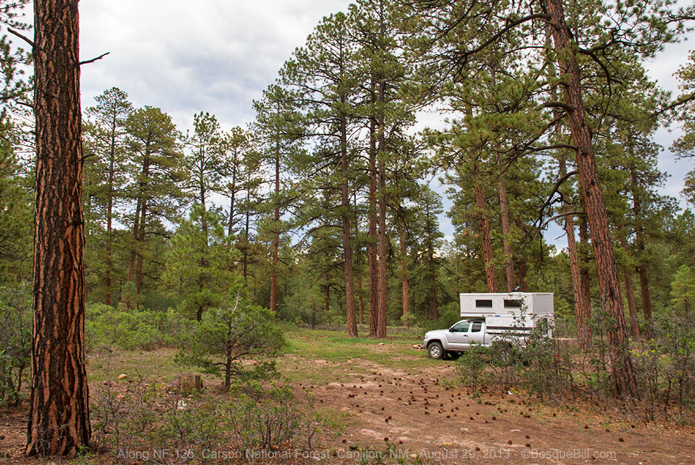
I drove all the way down to the junction with NF-125, a couple of miles in from the main highway, without finding a single passible campsite. I didn't want to go very far up 125 as I could see evidence that it would indeed get bad when wet, and the skies were already darkening and there were rumbles of thunder. I finally found a camping area about halfway to the highway with ground that looked like it wouldn't turn to gumbo in the first rain.

"Emergency" campsite

It was a little closer to the road than I would have preferred and was a bit on the well-worn side, but it was either that or head back home and end up driving late into the night as I didn't know of any camping between there and home. That night as the thunderstorm chased me into the camper and the rain went on and on, I wondered if I'd made the right decision. 

I remembered that I'd actually received a phone call from a friend while I was setting up camp and noticed at the time I had a good connection for data, as well. So, I opened my Wundermap app and checked the RADAR. I was relieved to see most of the storms were well to the south and the rainy area near me would soon pass away. That put my anxiety to rest and I was able to get a good night's sleep.


Friday, August 31, 2013

The morning dawned clear and bright. I had the satisfaction that I'd chosen my "emergency" campsite well, as the ground was wet, but not soggy. I traveled the short distance to US-84 and set off to the south with the goal to be home by early afternoon.

There were open vistas of tree covered hills and as red rock cliffs came into view I wished I'd left my camera set up for a few quick shots through the windshield. That reminded me that Echo Amphitheater was along here somewhere. I'd last been to it when I was still in high school when the youth group I was with stopped here for a picnic lunch on our way farther north for a camping trip. But like my last high school trip to Carlsbad Caverns, I was more interested in the cute girls on the trip than the natural beauty of the landscape - so didn't remember much about it. Plus, that was a lot of years ago.

There it was. Cool. I turned in for a couple of quick pictures, but as I drove up into the parking lot it looked interesting enough for me to pay the very modest fee and walk around.


The piñon and juniper provided an attractive contrast to tall sandstone cliffs in shades of cream and red. The sky was an incredibly deep blue. The chamisa and sunflowers were blooming. It was gorgeous and I took photos like crazy as I walked around, then up to the amphitheater itself.

Looking south along the cliff line toward the Jemez Mountains.

The paved trail up to the base of the amphitheater. Yes, you can hear your echo up there.

As I'd driven into the park area, I'd noticed they had a small campground which I hadn't realized was here. I drove the loop through the ten modest campsites on my way out, wishing I'd known about it the day before as it was much prettier than my previous night's camp. I'll remember next time.

Back on the highway, headed home. I soon reached the familiar area from my previous Jemez Loop trip, just a few weeks before. Though this time, after filling the gas tank in Española, I drove straight home. 

A wonderful journey around northern New Mexico with a short "detour" in Colorado. Thanks for joining me. See you next time!