
Part 3
Crazy Jug Point, Kaibab National Forest
North Rim of Grand Canyon National Park
Tater Ridge, Kaibab National Forest
Saturday, May 20, 2017 (continued)
Remember, you can click on any photo for a larger version.
Fredonia
I stopped briefly in Fredonia at the Forest Service District Office. I suspected they'd be closed on Saturday, but hoped there would be a map to look at and maybe some brochures available. Indeed they were closed, but the lobby was open with a Kaibab NF map on the wall behind glass, plus a large selection of free brochures and a Motor Vehicle Use Map for the district.
I was heading to Crazy Jug Point in the Kaibab National Forest that my friend Bob had recommended; Dawn had camped near there, too. It looked on the NF map that taking FR-22 out of Fredonia would be the most direct way there, however, the National Forest map also seemed to show that 22 didn't go all the way through - there was a discontinuity, so instead I followed Alt-89 to Jacob Lake as the brochure which gave directions to my destination started those direction from the visitor center there.
Kaibab Plateau Visitor Center
When I got to Jacob Lake it turned out that the Kaibab Plateau visitor center was indeed open on Saturday. Apparently this facility, operated both by the National Forest and the Grand Canyon Association is open daily due to the large number of visitors headed to the forest and the North Rim. It closes at 5pm, local time, so I just made it.
I bought the official NF map there (which was $15 rather than the ususal $10, but larger than most other NF maps). I discussed getting to Crazy Jug Point with the nice lady at the counter and pointed out that the map didn't show FR-22 as going all the way through. She was surprised as she knew it did. Turns out that is a error on the map printing. You can drive on 22 all the way from Fredonia to the Grand Canyon highway 67 near the Kaibab Lodge.
Crazy Jug Point, Kaibab Plateau
In any case, I set off from the VC via FR-461 & 462, following the Scenic Viewpoints brochure. I had to lose lots of elevation that I had recently gained on the main highway climbing up onto the plateau, so if coming from the west, FR-22 is the best way in and is actually paved part of the way.
Traveling down 22 you get a sense for just how large the Kaibab NF is - and this is just the northern part. FR-22 is gravel and in very good shape. After turning off 22 onto FR-425 the road is narrower and bumpier, but still in very good conditon. Another junction and the road, FR-292, is smaller, still. Then the last junction, take FR-292B to the point. It helped having a map as there was not a directional sign at every junction.
 |
| Early evening view to the southeast (iPhone photo). |
 |
| From the same location as the previous photo, just pointed a little to the right (iPhone photo). |
At last, Crazy Jug Point, and pretty late in the evening, too. I was glad to get here after a long day of driving, but I wasn't complaining as it had been an interesting drive. There is one dispersed style campsite at the point and I pulled into it. It is in the center of the turn-around loop and is surrounded by piñons.
 |
| Campsite in the middle of the cul-de-sac is big enough for a couple vehicles and tents. |
I was still figuring out where exactly to position my camper, when a soft-top jeep blaring rock music showed up and stopped at the point parking area. This couple with their enormous, free ranging dog were looking for a place to canyoneer. The fellow asked if I was camping there that night. I said "yes." He replied that they'd look elsewhere then, to my great relief. I suggested Monument Point, though I admitted that I knew nothing about it, but had seen the sign coming in. I hoped they'd land far enough away I wouldn't hear their loud music, which thankfully seemed to be the case.
 |
| Looking toward the southeast as the sun sinks. |
 |
| I'm guessing that rock formation in the foreground is the Crazy Jug. |
A couple other vehicles came by in the evening to look at the view. They looked like hunters with their beat-up trucks and full cammo attire. When they finally left I had the place to myself. There were no clouds to augment the sunset, but the colors in the darkening sky were beautiful.
 |
| The sitting sun through the trees. |
 |
| My campsite in the last rays of the sun. |
Sunday, May 21
Crazy Jug Point (continued)
 |
| The canyon was still in shadow, but this piñon at the point was lit by the rising sun. |
I was up at dawn to see if there were good photo opportunities. Not so much at dawn, but as the morning progressed I kept snapping. It was a beautiful morning.
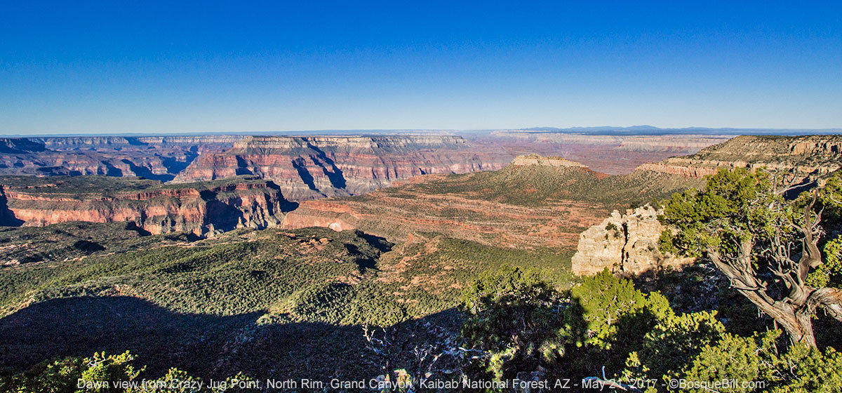 |
| Morning view toward the west. |
 |
| Pretty phlox flowers at my feet. |
 |
| Southwest view framed by the trees. |
You can't see off the rim from the campsite or parking area, so I carried my chair a little ways down the trail to the point so I could sit and admire the view. I also tried to photograph the many birds that were singing and flitting around - with minimal success.
 |
| The best bird photo of the morning - not a great image, but a great memory. |
One of the surprises, is that there was cell service on the point - if I stood in a certain place facing a certain way. Perhaps the tower was on the south side. In any case it allowed me to have a nice conversation with a friend and gloat about my view.
 |
| A nearly 180º panorama toward the west from the trail to the point. |
I broke camp and reversed course back to FR-22. There were smaller roads that looked like they might be more direct, but the first one I saw looked narrow and rough. I stopped to say good morning to a gentleman with a camera standing beside his small expedition vehicle emblazoned with "Switzerland" across the front. He was totally enraptured by the area. He said the national forest was larger than the whole of Switzerland. A statement that is hyperbole, but I understood the feeling. The area feels huge! Looking it up later, North Kaibab NF is just over 1000 square miles. They were headed to Crazy Jug Point.
I stopped to have lunch in a dispersed site before reaching FR-22. FYI, it seems there are dispersed sites sprinkled around the side roads, but none directly beside 22. There are many roads and scenic points to explore around the Kaibab Plateau. Those will wait for another trip as I was headed to the North Rim. FR-22 ends at Highway 67, the Grand Canyon Highway. I turned south on the pavement.
Grand Canyon National Park
I drove to the practical end of the road and found a spot in the parking lot. I stopped in at the visitor center. I wanted to enquire about the road to Point Sublime. I'd heard it was gorgeous, and it was a route in my Arizona 4-Wheel-Drive guide book. The book said you could get a permit to camp there, though everything else I'd read stated in no uncertain terms that there was no dispersed camping anywhere in the the national park.
The young ranger at the counter told me the condition of the road to Point Sublime was "nasty." She said they had not had the opportunity to clear the deadfalls from the road yet (The North Rim had only been open 1 week.) She said the fire crew usually did that task, but they were no longer permanently assigned to the park. She didn't know when the road would be cleared. I asked about camping. She said that the Back Country Office did, in fact, issue camping permits for Point Sublime and gave me the phone number so I could check with them later in the year. Their facility was just back up the road.
 |
| The view from Bright Angel Point. |
 |
| The view looking just to the east side from the point. |
I walked down the paved trail to Bright Angel Point. The North Rim doesn't get anywhere near the number of visitors as the South Rim, but there were still plenty with a constant parade along the trail to the point.
 |
| The point overlook from the rocks just above it. |
 |
| Panoramic view from Bright Angel Point. |
The view from the trail and the point was magnificent, but understand, it's not as spectacular or breathtaking as the views from the South Rim. The canyon is much broader, if that's the right term, on the south side. The Colorado River cannot even be glimpsed from Bright Angel Point. That didn't stop me from taking lots of photos, none of which really capture the space.
 |
| Cape Royal View |
I returned to my truck and drove north to the junction that would take me to the eastern viewpoints of the North Rim. I drove first to Cape Royal and took photos there and at Angels Window. I could at last see a piece of the Colorado River in the distance. I think the views from here are more beautiful than at Bright Angel Point, but maybe that's just me.
 |
| Another Cape Royal view. If you look carefully you can see the river, middle left. |
 |
| Another Cape Royal view. |
 |
| Looking more to the east with the river, middle right. |
 |
| Thor Temple as seen from Cape Royal. |
 |
| Another Cape Royal view. |
 |
| Angels Window at Cape Royal. |
 |
| A 180º panorama from the top of the Angels Window formation. |
I drove back up the road and this time took the turn-off to Point Imperial. This viewpoint looks toward the east. Unfortunately, by this time of the afternoon the clouds that had been building all day really began to negatively affect the light. I guess I'm just not skilled enough to turn those conditions into exciting photos.
 |
| This is probably the best of the photos I attempted at Point Imperial. |
 |
| A panorama from Point Imperial. |
It felt like it was getting late in the day and I needed to find a place to camp for the night. I'd noticed in that same Arizona 4-Wheel-Drive guide book a route that they marked easy* that would lead east from highway 67, up around the north side of the Saddle Mountain Wilderness, then down off the plateau meeting up with the Buffalo Ranch Road. From there I could check out the Buck Farm Overlook along the Colorado River.
*I had learned the hard way that what this book rated "easy" (Orderville Canyon Road) wasn't necessarily so.
I didn't really want to do the whole drive that day (and am so glad I didn't attempt to do so.) The book mentioned a side road that had beautiful dispersed campsites, so that was my plan.
Kaibab National Forest, Tater Ridge
The turn-off of 67 to the gravel road, FR-213, is halfway between milemarkers 601 and 602. A little more than 2 miles along is a right turn onto FR-221. This narrow dirt road has a few bumpy spots and a few pinch points where deadfalls had been cut, but not removed from the full width of the road. There are a few nice dispersed campsites, but continue on.
 |
| My campsite among the Ponderosa pines with a great view. |
I found a wonderful spot with a fabulous view east off the plateau 5 miles from the pavement. There would be room for several campers and the ground was suitable for tents, too. Although I was not far from the ridge line, the tall Ponderosa pines blocked the breeze. The cloud cover and the haze in the distance was not conducive to photography, but I kept trying to capture the canyon of the Colorado River down on the plain.
 |
| View from near my campsite of the southern section of Marble Canyon. I would head that direction the next day. |
Monday, May 22
Kaibab NF (continued)
 |
| One of the aspen groves along FR-213 |
I leisurely broke camp and drove back to FR-213 where I turned right. The road was smooth and passed through Aspen groves. After 4 or 5 miles I came to a small spur at the top of the ridge where one could camp if the wind was not strong, though there were trees, they wouldn't block the wind very much.
Then a very steep section of rocky switchbacks began. Some of the rocks were anchored and quite big. It was necessary to ease slowly over those. In other areas the rocks were baseball sized and loose. As I drove down I was thinking how difficult it would be to be trying to drive up. I didn't pause to measure, but I bet I lost about a thousand feet in elevation (good guess, according to Google Earth).
At the bottom, the road 'T's into FR-220. The guide book said to take a right. Left is a connection to the Buffalo Ranch TR #6 and is rated "moderate." To my chagrin, at the bottom of those switchbacks was a orange-diamond Road Closed sign. It sat to the right of 220, between it and where I'd just come down - a rather ambiguous placement. I wasn't sure if it referred to the tricky stretch I'd just done or the unknown road I was planning to drive, or even how recent it was.
I did not want to drive back up what I'd just descended, so I did what I'd advise anyone else not to do, I took the right turn and drove on. The road was rough and rocky. There were more switchback descents. I was paranoid that I'd get to the bottom of a gully and there would be a washout. On occasion I'd see tire tracks that looked like they might have been left by a road maintenance truck, such as a grader or front loader. My hope was that if indeed this road had been closed, that the truck ahead was clearing the way.
Consequently, I didn't enjoy this section as much as if I'd been assured passage. I knew if worst came to worst, I could reverse course. That would not be fun, but I didn't feel in peril. There was one short section, climbing steeply out of a gully, that looked bad enough that I put the truck in 4-wheel-LOW to climb out. There was only that one small section that required LOW, though I used 4-wheel-drive in many places just for traction, not that I was afraid of getting stuck.
East Side Game Road
 |
| I think that's Tater Ridge behind me (to the left) from whence I came. |
 |
| The canyon that ran next to this section of road. |
After what seemed a long time, and more loss of elevation, I came out on a ridge. The road ran along the side of a canyon. According to my navigation app this road is called the East Side Game Trail. I felt confident enough along this section to finally stop and take a few photos. As I continued, the road descended even farther onto the plain below.
 |
| The last section of road on the ridge before it drops down. I still wasn't 100% sure if the road was open all the way down, but I was feeling better. |
I was very relieved when I reached Buffalo Ranch Road, county 8910, which was wide and looked well traveled. By this time I felt I'd lost another 2000 feet. According to Google Earth (which I consulted while writing this post) I'd camped at 8580 feet; the top of the first switchbacks were about 8300'; and the junction with the county road was at 5565'. So yep, I was now 3000 feet lower than where I woke up that morning. I'd gone from fir & pine, though piñon & juniper, to sagebrush and grasses.
NOTE: the route I just took off the Kaibab Plateau is not for the faint of heart or for those without a high-clearance vehicle and the skills to drive it. That said, the section from the Grand Canyon Highway on 213 and 221 was readily accessible and I highly recommend my camping spot. A vehicle wider than a standard pickup truck would not have been able to drive between the sections of the fallen trees, but presumably later in the season the forest service would have come back and done a better job of clearing those.
That concludes my time on the Kaibab Plateau. My journey continues in Part 4 where I explore the Buck Farm Overlook and then Navajo National Park on my way home.


