Journey begins in
Part 1: Mount Taylor; Little Colorado River Gorge; and Marble Canyon
Part 2
Rock House Valley, AZ
Cottonwood Canyon, UT
Kodachrome State Park, UT
Skutumpah Road, UT
Friday, May 19, 2017 (continued)
Remember, you can click on any photo for a larger version.
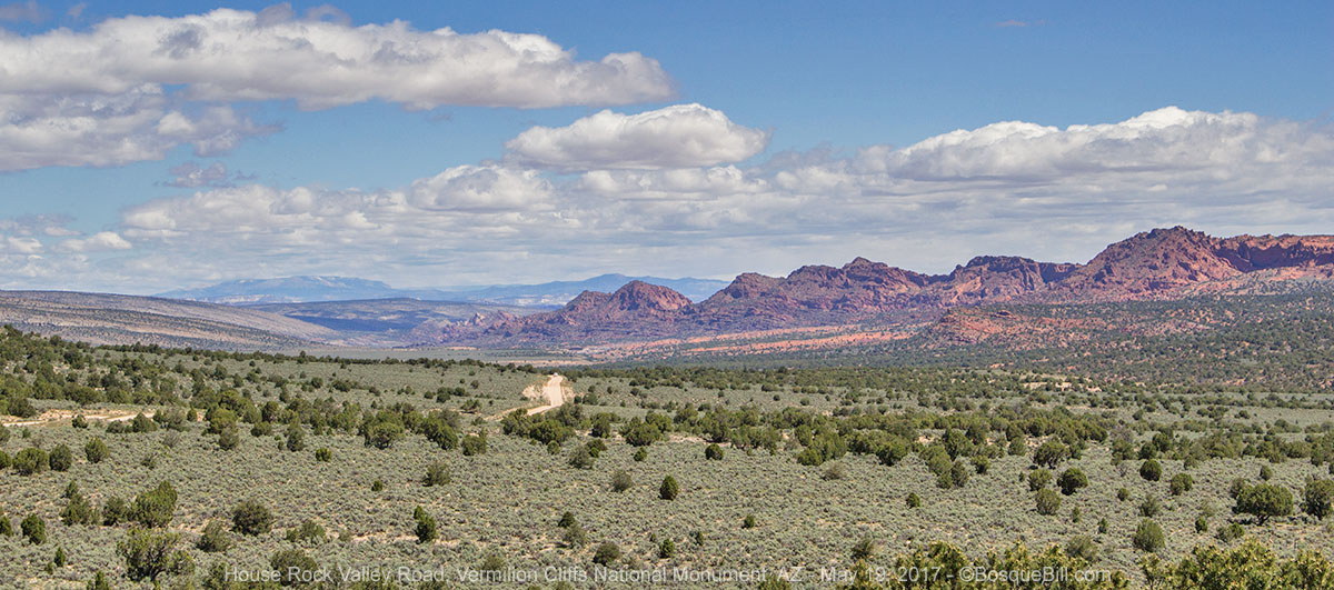
Rock House Valley Road
 |
| Entrance sign |
I turned north on Rock House Valley Road (a.k.a., House Rock Rd.) The road has an entrance sign for Vermilion Cliffs National Monument, though for the most part it runs along the border of the monument. I'd driven past this road before and it always seemed a lonely road. It may look like it's in the middle of nowhere, but there are lots of folks taking advantage of this great area. The road heads north between the Vermilion Cliffs and Kaibab Plateau. There are side roads in both directions and hiking opportunities, including a connection to the Great Western Trail & Arizona Trail.
 |
| Condor Release Viewing Area |
I talked with a fellow lowering the air pressure in his jeep tires. I asked him about it and he said his oversized tires made for a rough road. I continued on for a few miles and the washboard convinced me to follow his lead, especially as I was going to be on dirt/gravel roads for at least a day or two.
Aside from the colorful scenery, there are popular hiking trails and lots of roads to explore for OHVs. Whats the name for a collective of OHVs? The first time a group of 6 - 8 of them blasted past me on the road I thought I'd call them a gaggle like geese. When they all blasted past in clouds of dust the second time in less than a half an hour, I called them names I choose not to put into print.
Also, be advised the road can become impassible when wet. Some hiking trails require an advanced permit, while others require a permit that can be purchased at the trailhead at the time you start out.
I spotted a small boulder hill near the road. I pulled off to check it out and to have lunch. There was a dispersed campside next to the hill, which would be kind of nice if you didn't get too much dust from the road. While I was there only one SUV drove past and they did so slowly. I climbed to the top of the rock to take photos.
 |
| View of the dispersed campsite from atop the rock. |
 |
| View north from the rock. |
 |
| Along the road. |
 |
| Near the state line. |
The terrain becomes more rugged as you approach Utah. My friend Dawn, who had told me about Marble Canyon and sent me the link, also recommended the BLM run State Line Campground. It looked like a pleasant place, but it was way too early for me to stop this day. This
link says there are four campsites. I didn't count at the time, but it looked larger than that to me - maybe I'm misremembering.
Wire Pass
Less than 2 miles from the state line is the trailhead for Wire Pass. My WRT pal, Bob, had recommended hiking down the trail, then up Buckskin Gulch as an interesting slot canyon. Evidently, this spot is wildly popular. The parking area at the trailhead was packed with vehicles and swarming with people. It was like someone kicked an anthill. There was a queue for the permit kiosk and people were yelling to each other across the parking lot. I don't know if that's typical or if a group was meeting up, maybe I'll try the hike another time.
A few miles farther along the road the valley widens out and soon you are at US-89. I turned right, east, headed to Cottonwood Canyon Road. I'd only be on pavement for a few miles so left my tire air pressure low.
Paria Contact Station
I stopped at the Paria Contact Station for information. They had a color handout of day hikes in the Paria area, which will be useful next time; a brochure on "The Toadstools", which I'll also save for another trip; and a handout listing the mileage to various attractions along Cottonwood Road from Hwy 89. I asked if I'd need a permit to disperse camp along Cottonwood Road. They replied that permits were voluntary, but a good way to provide an emergency contact with the agency. I got a permit good for anywhere along Cottonwood Road.
I also asked about an unusual wildflower that I'd first seen on the WRT and saw again near Marble Canyon. Stalks grow out of a cluster of low, round leaves. When the stalks get about a foot high they swell many times in diameter, then a profusion of thin, branching twigs sprout from the tops of the stalks ending in tiny yellow flowers. Neither the ranger nor the lady working the desk knew of the species as I described it. As it happened, I had a photo on my phone which I showed them. I was delighted that the lady then found it in a wildflower book they had. It was a Desert Trumpet (Eriogonum inflatum).
Cottonwood Canyon Road
 |
| The beginning (south end) of the road. |
I passed the Toadstools trailhead and turned north on Cottonwood Road, a.k.a., Cottonwood Valley Road. Dawn and others had cautioned me about how the high-tension power lines and towers that marched up the canyon mared the view. In the lower, basin area, they were fairly easy to ignore. Later, not so much. There was also a profusion of small yellow flowers, blooming close to the ground. This is also a road that can become impassible when wet.
 |
| The road drops into a basin lined with wildflowers. |
 |
| The flowers grew low to the ground in great profusion. |
 |
Just before the road entered the canyon I saw this small herd of cattle with several calves.
The bentonite hills in the background may account for the slickness of the road after rains. |
As the road entered into the narrower canyon it follows the Paria River. From here on the power lines are obtrusive and impossible to ignore. I passed the trailhead to the Paria Box Canyon. The road no longer follows the Paria River, but a tributary, Cottonwood Creek. There are colorful rocks and soils, and the ever present power lines. I passed a couple of trailheads.
 |
| This is near the trailhead for the Paria Box canyon. |
 |
| These cacti were at my feet while to took the photo just above this one. |
Looking at the satellite view of this area now I can see that the canyon is actually part of a long fold in the earth, with very different geologies on either side.
 |
Many different colors and textures can be seen here.
If memory serves, my campsite was just to the left of where the road crests the hill ahead. |
 |
| North Cottonwood Narrows trailhead. |
About 25 miles up the road from US-89 you come to the Cottonwood Canyon Narrows. You can enter this slot canyon from either a south or north trailhead - it's either an out & back hike or you can return via the road. I talked to a couple of young men who were returning to their car via the road, after hiking the narrows. They said it was a great hike, though there were a few scrambles. It would have been nice if there'd been places to camp near either end of the canyon, but there was barely room for people to pull their cars off the road.
 |
| My campsite at the top of the hill. |
However, at the top of the hill just north of the north trailhead I found a wonderful campsite. The circular parking area at the top of the hill was bare, but there were trees and blooming wildflowers on all sides. There were several mini-overlooks where I could admire the views down and up the canyon and up the multi-colored canyon walls. As a bonus this is one of the few stretches of the road where the power lines were on the other side of a ridge.
 |
| View from the campsite. |
 |
| This photo was taken from the same place as the previous one. |
It was a little earlier than I usually stop while traveling, but a great place to relax. Throughout the afternoon and evening I'd move from viewpoint to viewpoint admiring the scenery, taking photos of flowers and trying to take photos of the birds that were singing in the area. Even though the camp was on the very top of a hill, the hill is so much lower than the canyon walls that there was no issue with wind. I suppose if you were unlucky and the wind whistled down the length of the canyon, it would be a different experience.
 |
| Rock formations along the top of the canyon walls in the golden light. |
 |
| A pinnacle to the north (taken with a telephoto lens.) |
 |
| Looking south, in the fading light, along the road from near my campsite. |
Saturday, May 20
Cottonwood Canyon Road (continued)
I took my time breaking camp in the morning so I could continue to enjoy this little campsite.
 |
| A common House Finch posed nicely in the morning light. |
I then continued north along the road. Very soon the terrain opened up with the canyon essentially disappearing.
Grosvenor Arch
 |
| The arches seen from the trail leading from the parking area. |
Within a couple of miles I came to the signed turn-off for Grosvenor Arch. Morning is not the ideal time to photograph this sandstone, double-arch. Had I known, I might have claimed my previous night's campsite, then driven the few miles to photograph the arch, then gone back to set up camp. Consequently, I made extensive use of the highlights/shadows sliders in both Adobe Camera Raw and Photoshop.
 |
| The view from below. |
 |
| About halfway between the arches and the state park, the road drops into Big Dry Valley. |
Kodachrome Basin State Park
 |
| Near the start of the Nature Trail. |
From the arch it was only six or seven miles to the entrance to Kodachrome Basin State Park and pavement. I'd heard positive reviews of this state park, so paid my day-use fee to check it out. It is certainly a popular spot. When I drove in I'd noticed a Campground Full sign. I asked about that at the entrance station (not that I was looking to camp there this day) and she said there were sites available; they'd not changed the sign. I asked if I had come in at 5pm the previous day would there have been a site available; she said "maybe", but there would have probably been room in the overflow area. So, I'd recommend reservations if you have plans to stay here.
 |
| A pinnacle along the Nature Trail. |
I walked the short Nature Trail. It was scenic with rock formations, plants and a few lizards.
 |
| See the repeating pattern? |
 |
| There were three of these "Blue Bellies" on this tree. |
 |
This is the dominant guy, puffed up to intimidate rivals.
I saw him and another wrestling, but the photos came out too blurred to post. |
Then I walked the recommended Angel's Palace Trail. The ideal time to take this trail is probably in the evening, not late morning, as I was doing. The trailhead is not far from the Basin Campground, so this would be a good walk for those camping at that location.
 |
| View from Angel's Palace Trail |
 |
| There were a number of these Sego Lilies before the trail climbed up on the rocks. |
 |
| Along the trail. |
 |
| Along the trail. |
 |
| You can see the Basin Campground (right) and trailhead parking area from this overlook. |
 |
| As I was heading back I took this photo of the trail climbing up. |
I met an interesting couple in the trailhead parking lot. Dan and Ann were touring in their Sportmobile. We had a pleasant chat and I recommended my previous night's camping spot to them.
Before leaving home I'd thought I would loop via the highway around to Zion NP next, but I'd received a text from my friend Bob that the tunnel in the park was closed due to a rockslide. This would have required me to enter and exit from the west and likely would cause the traffic to be even worse than usual. So, I decided to once again skip Zion.
I'd asked at the state park entrance station about Skutumpah Road as an alternative route to Kanab and hense, the North Rim. The ranger said it was a very scenic road and I'd have no problems with it. I passed the junction to that road, but proceeded a few miles farther into town to look for lunch.
Cannonville
I stopped at the nice BLM visitor center in Cannonville. The lady at the desk there didn't think as highly of Skutumpah Road - she thought it was generic, rather than scenic. But she confirmed the road was open. Unlike at the BLM Paria Contact Station she was adamant that permits were absolutely required for dispersed camping in the area. I didn't think I'd camp along there, but got a permit just in case, since she was so vehement.
I had thought I'd stop and have lunch in Cannonville, but there is not much there. The only commercial enterprise seemed to be a motel/gas-station/store, but there was a fellow with a trailer in the parking lot selling BBQ. I bought a pork sandwich that was ok. He seemed to be a local so I sought a third opinion about Skutumpah Road. He agreed that it was scenic, at least the northern parts. He said there were some interesting trails and cautioned me to drive slowly up the steep hills as sometimes there were rocks or holes you didn't want to encounter at speed.
Skutumpah Road, a.k.a., Deer Valley Ranch Road
I backtracked south from town and turned right at the sign for Skutumpah Road. It climbed rapidly out of the basin and I stopped to photograph the lowlands I'd just come through.
 |
| A view from the top of the road above the valley. |
 |
| From several places along the road you can see the Pink Cliffs of Bryce Canyon NP. |
 |
| Averett Canyon has colorful soils and rocks. |
I drove on, not encountering anyone, other than a few cars parked at trailheads. There are three trailheads for slot canyon hikes along the northern portion of the road. You first come come to Willis Creek Narrows, which I've read is rated easy. Next is Bull Valley Gorge. I stopped there as the gorge dramatically passes under the narrow road. It's a long, long ways down. From what I've read since my return, this gorge is a much more challenging hike, though not rated difficult.
 |
| Looking down the gorge from the road. |
 |
| Looking up the gorge from the road. |
 |
| Looking back toward the road crossing from up along the canyon. |
As I looked down I saw folks walking along the bottom. They mentioned a "jeep" stuck in the crevasse below the road. I walked up the gorge and tried to get a photo. My photo was not very successful. A better photo and the story how three men died when their pickup rolled into the gorge in 1954 can be found on the
Utah Adventure Journal page.
 |
| Butterfly and flowers along the edge of the gorge. |
I continued south on the road and finally encountered a vehicle coming the other way. We stopped to say hi. They'd been hiking in the third of the canyons, Lick Wash, which they recommended. It is a deep canyon, I've read, with only a few slot sections. This hike is also rated easy, though you can hike farther if you desire.
The road has opened up by the time you reach Lick Wash. There are views of the cliffs of Bryce Canyon National Park.
 |
| View of Bryce Canyon NP. |
 |
| A view of the Pink Cliffs using a telephoto lens. |
The road rolls through the private lands of Deer Valley Ranch. In less than 10 miles you come to the junction of the paved Johnson Canyon Road. I turned left here after stopping to air up my tires. I have to raise my truck hood to clip the pump leads to the battery. That gives the appearance I'm having mechanical problems and a nice fellow in a jeep stopped to see if I needed help. I said I was "airing up" and thanked him for stopping.
The southern terminus of Johnson Canyon Raad is US-89, where I turned right and drove into Kanab. I filled my gas tank there, then turned south on Alt-89 toward Fredonia and the North Rim.
The journey continues in
Part 3: the North Rim of the Grand Canyon.


No comments:
Post a Comment
Thank you for taking the time to comment. I really appreciate it!