
Comb Wash, South & North Mule Canyons, Edge of the Cedars, Bear's Ears
Monday, October 24 (continued)
This post is a continuation of the journey begun in Part 1.
Remember to click any photo to see a larger version - highly recommended.
Comb Wash
 |
| Comb Ridge seen from eastbound US-163. Interestingly enough, the ridge is red on the west side and white on the east side. |
I'd seen the turn-off to the dirt road up Comb Wash when I'd driven US-163 west of Bluff any number of times. Folks I met near Moab on my last trip recommended it as both a drive and destination. I would drive north from 163 to UT-95, exploring as I went. If the weather forecast was right, I would clear the area before the expected rains came. This might be important as I knew the road crossed several arroyos before it regained the highway.
 |
| Comb Wash Road with Comb Ridge to the east. |
 |
| My curiosity becomes peaked whenever I see a ridge of white stone pushed up in the middle of red sand and stone. |
Though the turn off is not marked, once you are on the dirt road you should see a sign, San Jan County 235. The "comb" cliffs mark the eastern boundary of the wash and the edge of Cedar Mesa, the western border. There is mostly red dirt and sand, but the views are wonderful. A few miles up the road, the route splits. The left, west, fork becomes Snow Flat Road and ascends the mesa - this is the Mormon Emigrant Trail. The right fork crosses the wash and continues north.
 |
| The road below is the folk which becomes Snow Flat Road as it ascends Cedar Mesa |
 |
| Yipes! Stripes! |
There are cottonwoods growing along the wash bottom and as you get closer to UT-95 there are a number of dispersed camping areas - some near the cliffs on the east side of the road, a few others closer to the cottonwoods and the wash. I found one under the trees, with some intersting rock formations to the west, that I want to return to next season.
 |
| On the west side of the road are cottonwoods along the wash and interesting sandstone formations. |
A mile or so south of UT-95 I passed the BLM camping area in which I spent one night last trip. I decided to cross the highway and explore the dirt road farther up the wash. There are a couple of dispersed sites just off the highway, but the road then passes through part of the Ute Indian Reservation and they have No Trespassing signs along the road. Theoretically, the road continues north, but there was a deep-looking river crossing I thought wasn't worth trying, so I turned around and drove back to the highway.
Mule Ruins Interpretive Trail
 |
| Restored kiva at the Mule Canyon Interpretive Trail |
I drove west on 95 to check out the Mule Ruins Interpretive Trail. I found the ruins and interpretive trail, just off the state highway, to be a bit of a disappointment. They would, however, serve as a good introduction for tourists driving through with little time and less experience with ruins in the area. Unless you fit that category, I'd say spend your precious time elsewhere.
Cave (Tower) Ruins
I headed back east on the highway to look for the turn-off to Tower Ruins. You would be wise to pick up one of the hand-drawn maps at the Cedar Mesa Ranger Station if you wish to find these ruins and/or South or North Mule Creek access. Also, be sure to pick up a free copy of the Cedar Mesa/Grand Gulch Trip Planner - a vital reference for hiking and camping in the area.
The road to the tower ruins goes from bad to worse. The first section can be done with any moderately high-clearance vehicle, but I recommend parking in the lot by the first informational kiosk and walking from there. I tried to drive the next part and abandoned the effort about halfway as it was just too rough. Turning around was no picnic, either.
 |
| This tower was close to the head of the canyon. |
There is not much left of the towers. The theory is that they were built to protect the spring and pool at the head of the canyon, but no one living really knows.
 |
| Looking across the head of the canyon at a tower. |
South Mule Canyon Bluffs
To find the road to South Mule Canyon - the actual canyon, not the interpretive site - look for the sign for "Arch Canyon - Texas Flat." The road is on the north side of the highway. There is a permit kiosk a short way in, as this is a fee area, then you drive only a bit farther to the canyon. Generally Mesa-top car camping is free and doesn't require a permit, whereas hiking and back-country camping do require permits. Permits are available at the ranger station and at many trailheads.
Looking at a satellite view before leaving home, it appeared there would likely be dispersed camping sites just beyond the South Mule Canyon trailhead on top of the canyon rim and there were. I did continue down the road just to see what was around and noticed others camped farther along. I turned around shortly after the bridge crosses the wash of North Mule Canyon.
 |
| It is hard to see, but my camping spot is not far from the canyon rim. |
I initially thought once I'd set up camp on the bluff above South Mule Canyon, I would hike from there down to the trail which leads up to the House on Fire ruins. But I could see rain on the horizon and light sprinkles changed my mind. The precipitation was light and intermittent, so I decided just to stay in the area around where I'd camped. I was able explore the canyon rim a bit between showers before dark.
 |
| Slickrock and vegetation near my campsite. |
Tuesday, October 25
Although it didn't rain very much overnight, it was dark and chilly the next morning. Everything was wet and I would be too if I decided to hike. I decided I'd break camp and drive into Blanding as I heard Edge of the Cedars museum there had a great collection of ancient puebloan artifacts and there was a small ruin, too. I could also get gas, have lunch in town, and maybe the skies would clear. My intention was to then return to hike South Mule Canyon with the sun shining.
Edge of the Cedars
To get to the state park/museum you turn off the main street in Blanding and drive several blocks though a residential area. There is a modest fee to enter the museum, and it is well worth it. They have a very diverse collection of artifacts on display. I especially enjoyed the "discovery" displays - be sure to read the discovery stories on the wall posters to learn how ordinary hikers came across these marvelous discoveries. This is their website.
I have a dozen additional images posted on this photo page. I strongly encourage you to view them.
 |
| The Discovery collection. |
 |
| The ruins behind the museum. |
I have a dozen additional images posted on this photo page. I encourage you to view them.
After the museum I had lunch, then retraced my route back to the west.
Butler Wash
I'd seen the sign to the Butler Wash Ruins on UT-95 west of Blanding on my drive in that morning. The trip planner states that it is only a hike of about a mile round trip to see the ruins.
 |
| Looking south from the trail. |
The trail starts on sandy soil though the piñon and juniper, then transitions to slickrock. There are a couple of slightly steep parts, but mostly the trail is easy. There are cairns to follow on the slickrock and most of those have been cemented in place. Your destination is an overlook with the ruins about a hundred yards across the canyon (if my memory is accurate.) You might wish to bring a small pair of binoculars along to view the ruins.
 |
| View of the ruins from the overlook. |
 |
| A closer look at the main section of the ruins. |
I walked back to the parking area, and again drove west on UT-95 to the road to Mule Canyon.
South Mule Canyon
I pulled off the highway, stuffed my two dollars in the permit envelope, and after dropping it in the slot drove down the hill. The trailhead is in the first canyon you come upon, approximately a quarter mile from the highway. You just park alongside the road. The trail drops off the upstream side of the road and winds up the canyon.
I have posted eleven additional photos of South Mule Canyon, including House on Fire Ruins, on this photo page.
 |
| Looking back toward the trailhead, not far from the road. |
 |
| Canyon walls along the trail. |
Much of the trail is alongside the bottom, though you cross over a number of times, and walk up the wash in places, as well. The hike is described as easy-to-moderate by BLM. After about a mile you come to the House on Fire ruins. I gather it is so named because the coloration of the rock can look like flames in the right light.
 |
| House on Fire Ruins |
 |
| From the west side you can see the ruins clustered under the enormous rock cliff. |
There are supposed to be three other ruins farther up the canyon, each about a mile from the other. I hiked up another mile, but didn't spot any other ruins.
 |
| There are beautiful scenes all along the canyon, such as these majestic Ponderosa Pines. |
It is a very pretty hike up the canyon and fairly easy. When I was just about back to the trail head I spotted several Mule Deer grazing along the canyon bottom.
 |
| The canyon is a haven for deer as there is no hunting anywhere on Cedar Mesa. |
I have posted eleven additional photos of South Mule Canyon, including House on Fire Ruins, on this photo page.
North Mule Canyon campsite
After my hike I drove north on the dirt road. North Mule Canyon is about 3/4 of a mile farther along. The previous evening, as I was driving around before settling in my campsite, I had noticed a particularly attractive campsite just past the bridge at North Mule Canyon. There was a large van set up, with solar panels deployed, just above the canyon bottom under a cottonwood. There were pools of water in the creek bed and interesting rock canyon walls. I drove there to see if it was now available and lucked out, the site was empty. I drove down the short access road into the shallow canyon. It was easy to find a level spot. I set up and deployed my solar panel as there was still enough sunshine low in the afternoon sky.
 |
| Lower North Mule Canyon seen from my campsite. |
It is a lovely spot on a wide terrace slightly above the canyon bottom. The canyon here is shallow and I enjoyed just sitting in my camp chair and enjoying the view.
 |
| My campsite as seen from the north canyon rim in the early evening. |
Wednesday, October 26
My initial plan was to take a short hike, perhaps down the canyon, then move on. As I wandered around camp taking photos, the peace and beauty of this place began to seep into me. I realized that I'd subconsciously reached the decision to stay here another day. I had already deployed my solar panel, so now I decided to raise my tarp awning, as well. That would provide shade for the camper, especially the area of the fridge, in case the sun became hot later in the day. I lounged around camp, took a few more photos, then got ready to hike up the canyon.
 |
| Autumn leaves. |
 |
| A Golden Aster thriving in the rock. |
 |
| Such a beautiful and peaceful campsite. I hope to return here again. |
 |
| I haven't been able to determine exactly to which species this little chipmunk belongs. |
North Mule Canyon
Fewer folks hike North Mule Canyon than the South, which has House on Fire ruins and is an easier trail. The trail, here, is a bit more obscure in places and spends much more time at the bottom in the wash area, so is a bit more difficult, but never that hard.
There was an older couple just beginning to hike the canyon at the same time as I. I realized from what they were saying that they were under the mistaken impression they were in South Mule Canyon. I let them know this was the north canyon and House on Fire ruins were in the other canyon. I gave them directions to the other trailhead, they thanked me and turned around.
I have posted all these photos and ten more on this photo page.
 |
| Mind the gap. The trail skirts around to the left. |
 |
| Much of the trail is simply the canyon bottom. |
North canyon is not as large or quite as spectacular as South canyon, but every bit as beautiful. About a mile up the trail under a low rock ledge were two walls, all that remains of a small ruin.
 |
| Only two side walls remain of this small ruin. |
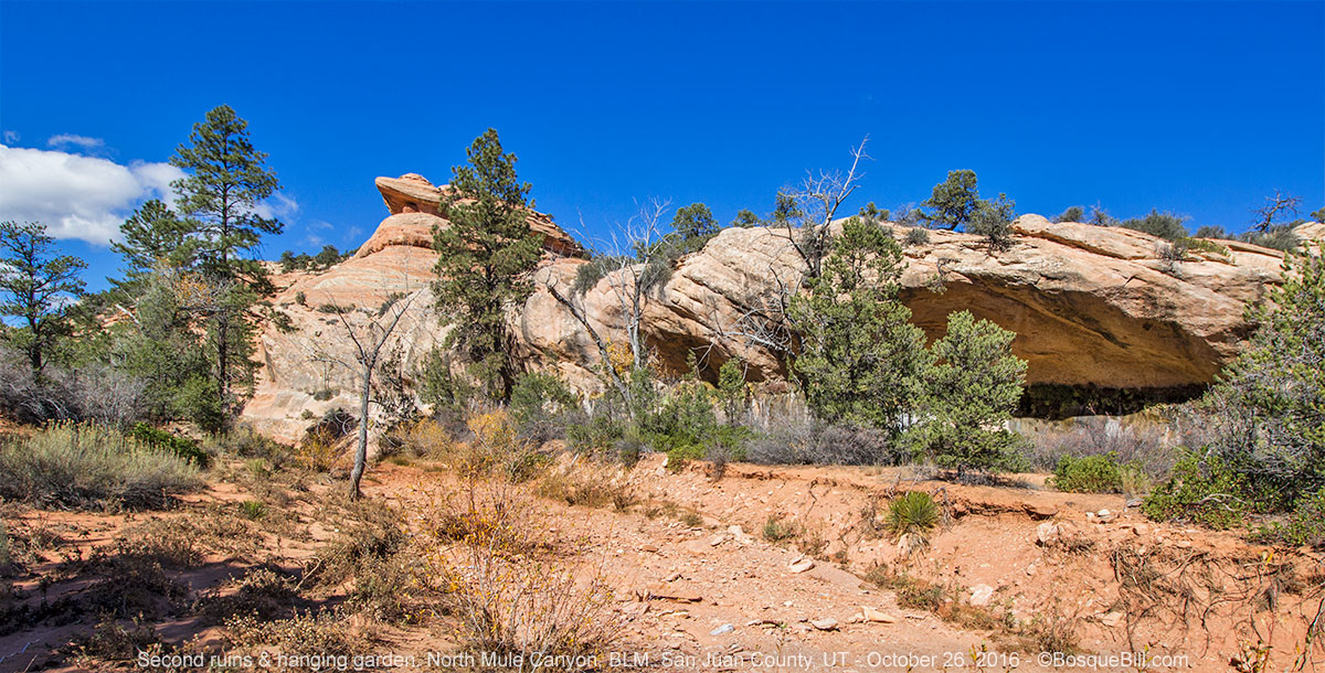
Another mile up canyon is a dramatic promontory marking the area where the canyon forks, though the spur is much smaller than the main canyon. I could see evidence of some sort of ruin near the top of the high rock. It would be a great place for a look-out, though it may have also been just a granary. You might wish to bring a small pair of binoculars along to view the ruins.
 |
| Promontory and hanging garden. |
 |
| A closer view of the promontory and the small ruin tucked into the overhang. |
Below the promontory was a small "hanging garden" under an overhang, the first I'd seen, though I read they are not uncommon in these canyons. They are formed where water seeps out from between the rock layers of a wall face.
 |
| A closer look at the hanging gardens. The dark crescent is simply the shadow of the overhang in difficult lighting conditions. |
A little ways up canyon were the ruins of several rooms along the cliff face, not far from the canyon bottom. It made me realize that although Moon House was a clearly defensible cliff dwelling, the peoples who settled in Mule Canyons had no such fears and built low in the canyons, on terraces just above the level of flood waters.
 |
| Ruins perched on a terrace below the promontary. |
Curiously, I met another couple hiking here who thought they were in South Mule Canyon. I had a hard time convincing them that they were in the north canyon. It seems they had a map from the visitor bureau in Blanding that had the wrong milage listed to the trail head from the highway.
Once I visited the lower ruins, I turned around and made my way back down the canyon to my camp. My right knee wobbled a bit on the way out and I realized I'd put it through much more than usual on this trip.
 |
| One more look at North Mule Canyon. |
I have posted all these photos and ten more on this photo page.
Back in camp, I moved my solar panel to point more directly into the sun. It worked great on this trip. I sat in my chair to relax after my day and to enjoy the scenery around camp. I sat so quietly that a number of deer wandered though. They kept an eye on me, but as long as I didn't move, they didn't bolt. Afternoon turned into a beautiful evening with a colorful sunset.
 |
| Mule deer across the stream from my camp. |
 |
| A beautiful sunset in camp this evening. |
 |
| A contrail cuts through the clouds. |
Thursday, October 27
I would head home today, but wanted to explore a bit of the national forest north of Cedar Mesa. I drove up the road toward Bear's Ears Pass, stopping a couple of times to admire the view south and west.
Bear's Ears and Elk Mountain Road
I realized that, although I had seen and admired Bear's Ears peaks while on Cedar Mesa, I failed to take a photograph. Driving up toward the pass I was too close to remedy that situation.
 |
| View from Elk Mountain Road as it climbs towards Bear's Ears Pass. |
 |
| Natural Bridges National Monument as seen from Elk Mountain Road. |
 |
| The western ear of the bear. |
I stopped at the pass for a few more photos and drove on. After days at lower, dryer elevations I was now in among the pines, spruce, and aspen. I had been cautioned, before I left home, that this road quickly became impassible when wet and I could see evidence of that even two days after only a moderate rain.
 |
| View of the national forest north of Bear's Ears Pass. |
I stopped at the Arch Canyon overlook. The atmosphere was extremely hazy. I was surprised to just be able make out the profile of Ship Rock on the horizon. Can you see it in the image below?
 |
| Hazy view from Arch Canyon Overlook |
 |
| Abajo Mountains with white canyons to their south. |
I continued on Elk Mountain Road which curves east, affording great views of the Abajo Mountains with white sandstone canyons at their feet, then back south to UT-95. From there it was highway all the way home.
Epilog
This was the last camping trip of the season. My camper is now safely tucked inside my garage for the winter months. I didn't get out as many times this year as in past years, but every trip was great fun and filled with wonders. Thanks for following along!
P.S., I came across this interesting website should you be thinking of visiting any of the wonderful areas from this trip.


