Showing posts with label Odonata. Show all posts

Wednesday, September 13, 2023

SE San Juan Mountains, CO & NM: Part 2

Part 2 of 3; Story begins in Part 1

Remember to click on any photo for a larger version.


Wednesday, August 23

East Fork Dispersed Camping Area (continued)

When I got up in the morning I could smell wood smoke. Apparently the wind shifted and the wildfire smoke was drifting this way. I'd thought I'd spend two days in this area, but the situation had changed. I had breakfast, broke camp, and headed back to the highway.


Rio Grande National Forest

I turned north on US-160 and drove up and over Wolf Creek Pass. In looking at the map I'd seen a road I'd not explored that took off east of the highway to Big Meadows Reservoir. There was a USFS campground there, but the road continued on and perhaps there was dispersed camping up there that way.

Big Meadows

I turned off the highway and shortly saw a large sign that stated camping was only allowed in designated campgrounds. That seemed to put the kibosh on dispersed camping. I went ahead to check out the reservoir and campground. Looks like a good place for folks who want to fish for lake trout. I didn't check the regulations, but I suspect they allow small trolling boats, not that I saw any. 

Big Meadows Reservoir

The campground was situated up the slope beside the lake. There were sites with views, but they were generally close together and well populated. I took a couple photos and headed back to the highway. I was asked later if there might have been dispersed camping farther along the road. At the time I thought the sign was all inclusive, but don't really know. If you're interested the District Ranger could tell you.


Eastern San Juans

A few years ago I'd driven up the Conejos River Valley from CO-17. I'd camped in the official dispersed camping area, then continued on to Platoro, then up and over and down Park Creek Road, FS-380. I seemed to recall there were campsites along there. I thought I'd go up that road and around the summits, but skip the Conejos River road as it was miles of miserable washboard. Instead I'd go out by following the Alamosa River which would be new to me.

With this in mind I found and followed Park Creek Road. Sure enough there were camping spots along the river, most of which were occupied. I did find one that was available, but there was a lot of ATV traffic kicking up dust along the road. I kept going and from looking at the satellite maps before my trip knew there were meadows along the river farther up that might provide camping.

Black-tipped Ragwort and Fireweed

One of those meadows was hosting what looked like a jamboree. I passed another that looked promising and backtracked to check it out. There was one large trailer but the double-track appeared to follow the river and I saw no campers there. When I started up the track I found the reason why. The area was blocked off for landscape rehabilitation purposes. Oh, well, onward and upward.

Black-tipped Ragwort, AKA Roadside Senecio, and some stinkweed, too

I checked out a few side roads, but most were pretty gnarly. Another looked sort of OK, but on closer examination the potential campsite was covered in cow patties. Yuck. Another had neither a view or creek access. Since it was still early due to my quick exit from the fire zone, I kept going. When I reached the top there was an interesting spot with a fabulous view, however a chilly wind was kicking up and the site was exposed. I kept going with a Plan B in mind. 

View from the top

A better photo of a Cop Car Moth

Big Red Mountain

On my earlier trip I'd stopped in a small primitive campground near the Stunner mine site to have lunch. That would be my fallback option.


Stunner Campground

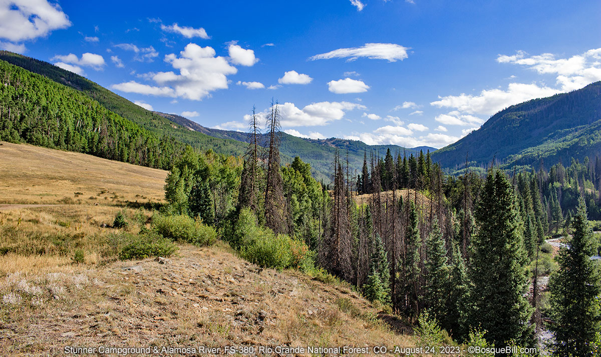
It's good to have a Plan B. As I pulled into the campground I was the only one there. It has a half dozen nice sites with picnic tables and a metal fire rings. There is one vault toilet. It was only around 2pm, but I found a pretty site that was level for the camper and could catch some sun if the clouds would cooperate. I took the site rather than drive until I'd exhausted my options and myself.

My campsite with a view of the meadow and valley

Alamosa River as seen from my campsite

Stunner is named for the mining camp near here established in 1892. According to signage 400 miners, gamblers, and camp followers came to this spot, but many quickly moved on. There is supposed to be remnants of the camp around, but I didn't see any.

I was fascinated by the intense blue of this little Gentian

An "artistic" shot of a little paintbrush

I had a pleasant afternoon. One jeep came in with two older couples who had a picnic for an hour across the way. A forest ranger came by to check on the little wetland there have, which I know as I was out looking for flowers to photograph so was able to speak to them briefly. I'd actually had a lazy day, so after dinner I walked the half mile access road back to the "main" road and took a picture of an old cabin there at the junction. Though not in good shape it is much too new to be part of the old mining camp. It was a nice quiet night.

Old cabin—perhaps a defunct forest guard station


Thursday, August 24

Stunner Campground (continued)

No need to rush out of camp this morning and no reason to stay, either. After breakfast I wandered around and took a couple dozen photo of the birds—none of which were worth saving. Got a good photo of a chipmunk, however, as he charged along the road right at me, until he saw me.

Chipmunk suddenly realized I'm standing here.

A beautiful morning in the Alamosa River valley

Here is a spherical panorama of the area:


I'd drive down the Alamosa River Road, FS-250, and see what was there. The map showed a campground situated along the river near the end of the national forest which I'd check out. But most likely I would proceed back to the highway south of Alamosa and head to my favorite northern New Mexico camping spot on the Rio de los Piños River. That would be a very nice conclusion to my trip.

Alamosa River Road

It was a very pleasant drive on a gravel road in good condition. The river was on my right as I drove through the aspen. I kept my eyes peeled in case there were any turn offs to dispersed campsites along the river, but didn't see any. I found one site on the mountain side by a tiny creek, but it wasn't level.

Just before I got to Jasper. I saw a pond right next to the road. I pulled over to see if there were any dragonflies and sure enough I quickly spotted some flying by. I parked and tried my luck.

Alpine dragonfly pond

I enjoyed about 45 minutes of walking around two sides of the pond trying my hand at capturing whatever critters I could with my camera. The first image here is not very good, but I'm posting it as a reminder to always check my settings before shooting. I had a golden opportunity with a usually fast moving darner hovering still in front of me and my shutter speed was too low. He never cooperated again. I heard at least two Pika calling from the talus on the far side of the pond, but never saw them.

Paddle-tailed Darner at too slow of a shudder speed

Northern Bluet damselfly

A terrible pest, but pretty

Northern Bluets in tandem

A Northern Spreadwing—my first

Enormous dragonfly... or perhaps a juvenile Broad-tailed Hummingbird

Alamosa Campground

Jasper is simply a long strip of private land which extends a mile or so farther downstream where folks have built cabins and summer homes. I saw no businesses. There is a last section of the national forest before more private and state land. The Alamosa Campground sits at the bottom of the forest land and is a very pleasant, free campground on the river. There are a half dozen sites, three on the river itself, and one vault toilet. Two of the river sites seemed to be long-term campers; 4 the other sites were open. I found a spot to rest and have a picnic lunch.

Continuing down FS-250 one quickly leaves the pines and conifers for a drier area of piñon and juniper. The road skirts Terrace Reservoir before being directed into a parallel valley. At that point I changed over to FS-255 which would take me south and east to Capulin over dry and dusty gravel roads though desert like terrain. From there it was a straight shot east to La Jara and US-285.


Conejos County

One of the eBooks I'd brought along turned out to be a short novella rather than a full-length novel, so I wanted more reading material. Once I was back on the grid I tried to use my phone as a hot-spot to access the online library. For some reason this just didn't work. Rats! A couple miles south on the highway is a USFS office I stopped there to see if they had WiFi. They had guest WiFi, but it wasn't working. The young man working there provided directions so I could go back about a mile to the county library to use their WiFi. I did and asked the librarian if a traveler could use their WiFi. She wrote out the password for me. I was able to return the books others where waiting for and check out a hold that was ready for me. Excellent.

I filled up the truck at an unattended, credit card only gas station in Antonito, CO. It also seemed to be the only gas in the village and offered only regular grade. Fortunately it was at a good price. 


Story continues in Part 3


Sunday, September 27, 2015

Southeastern New Mexico - September 2015

After my enjoyable trip to SW New Mexico and the Ode Blitz last month, I was primed to take another trip to look for new dragonfly species in the southeastern part of the state. I hoped to time my trip to attend the Dragonfly Festival at Bitter Lake National Wildlife Refuge, then continue farther south to the Carlsbad area. I wanted to check out Dog Canyon in Guadalupe Mountains National Park, as I'd heard good things about it. Then I'd return home after a quick survey of the Sacramento Mountains where I'd never been.

Remember, to view larger images click on any photo - highly recommended.

Part 1 of 2:

Pecos Basin and the Guadalupe & Sacramento Mountains


Sunday, September 13th


Bitter Lakes National Wildlife Refuge, Roswell


I'd delayed driving down to Roswell for the annual Dragonfly Festival as the weather forecast had been for clouds and rain on Saturday. Odonates depend upon direct sunlight to see, as their vision is tuned for polarized light. Consequently they don't fly, and are therefore hard to find, when it is overcast.

Bitter Lakes NWR

I arrived late morning and was disappointed to find the Visitor Center was closed; I'd hoped to replace my dragonfly mug that fell off my kitchen counter and shattered. The tours were ongoing, but the facility was closed.

Bitter Lakes NWR Visitor Center overlooking one of the lakes.
Bitter Lakes National Wildlife Refuge is popular with birders and hosts migratory water birds in winter, such as Ross & Snow Geese, ducks, and a large Lesser Sandhill Crane population. Though near the Pecos River, much of the water here comes as artesian flows from the mountains far to the east. Of course the many dragonfly species is what generates interest in the annual festival.

Desert Whitetail at Bitter Lakes

My last minute plans precluded me from reserving a place on any of the official festival tours, but I did run into one old friend and caught up, but missed my other buddy. It was hot and I checked a few spots in the refuge for odes on my own, but didn't find much.

One of the highly saline lakes at the south end of the refuge colored by algae.

Lea Lake Outflow Wetlands


Lea Lake Outflow Wetlands with storms building on the horizon

I drove over to the Bottomless Lakes State Park area to check the Lea Lake Outflow Wetlands, which is on BLM land. By the time I got there the wind was picking up and gusting - not good for dragonfly photography. Worse, before long a thunderstorm rolled into the area. This is not what the forecast had promised. Bummer!

Bleached Skimmer at the Outflow Wetlands.

It was way too hot to camp at the state park, so I returned to Roswell and got a motel room. I'd researched motels via Google maps before I'd left home, just in case, and chose the moderately priced one rated 4 stars. The stars didn't lie, it was very clean and comfortable. I was able to relax in the air conditioning and watch baseball on TV.

Monday, September 14th


After breakfast at the motel I drove down to Carlsbad. I stopped at the National Park Service office to check status of Dog Canyon and ask about the roads. Then I stopped at the Lincoln National Forest district ranger station to get the latest info on the areas I hoped to visit and to purchase a map for the northern two districts.

Black River


The Black River as it flows under the county road. Cool dragonflies were found here.

South of Carlsbad I turned onto Black River Village Road to see if I could find a way to access the Black River and look for dragonflies. There were no locations or records that I could find from this area, but it looked promising on Google maps satellite view. About half-way between the US highways the county road dips and crosses the (small) river. I later learned that this spot is called Harkey Crossing. There were places to turn off on the south side of the highway. The river backs up a bit here, enough to form swimming holes and party spots for the locals, who left a lot of trash, unfortunately. But on the positive side, I was able to find several interesting dragonfly species, including two I'd never seen or photographed before, a Swift Setwing and a Flag-tailed Spinyleg that is not often seen in New Mexico.

Swift Setwing along the Black River

Rattlesnake Springs


From there I drove back to US-180 and south to the turn off to Rattlesnake Springs. The artesian pond and adjacent picnic area are administered by Carlsbad Caverns National Park. This location has been known as a birding hotspot for many years and now with the increased popularity of finding and photographing Odonates, a hotspot for us as well.

The artesian pond at Rattlesnake Springs - here be dragons.

As soon as I parked and walked over to the outflow canal from the pond I saw two interesting dragonflies, which I later identified as an Eastern Ringtail and one of my target species for the trip, a Yellow-legged Ringtail. They were more concerned with each other and not me, so was able to sit on the lawn and take lots of photos. One more new species for me.

Less than two weeks before, a Thornbush Dasher dragonfly, a species that had never before been recorded in New Mexico, was seen at this pond, so I began a slow walk around the pond to see if it was still there. About half-way around I spotted it perched on a stick toward the middle of the pond. I took some photos, but it was not very close and was facing the other direction. I continued to walk around the small pond.

Suddenly at my feet were literally dozens of Desert Firetails busily going about the business of insuring future generations. This was a damselfly I'd spent two days looking for last month at the Ode Blitz and only got once brief chance at a photo that entire time. Needless to say, I took many photos.

Desert Firetail at my feet

A bit later, I found the Thornbush Dasher again. This time it was perched perfectly in the sun, posing for my photographic pleasure not too far from the edge of the pond. I took lots and lots of photos of this gorgeous bug with its metallic blue eyes which made me very happy.

The prized Thornbush Dasher at Rattlesnake Springs

  • If you are interested in viewing photographs of all the Odonate species I photographed on this trip, click this link.

Dog Canyon


From there I drove back to Carlsbad for a very late lunch and headed southwest on NM-137 to Dog Canyon. This campground and ranger station is part of Guadalupe Mountains National Park. It is so remote that, although it is in Texas, the only way to drive in is via New Mexico. The last time I'd visited GMNP and hiked McKittrick Canyon, the folks I'd met told me what a beautiful place it was. It is a long drive along the state highway, up onto the plateau of the national forest, down the other side, then south to the very end of the road.

As you drop off the plateau, this magnificent vista of the Guadalupe Mountains opens up.
Dog Canyon sits at the head of this basin. The photo is looking south.

Well, it certainly has the rugged beauty of high desert mountains. The tent sites at the campground are quite nice, nestled in among the trees. The campsites for truck campers and RVs is a grassy parking area in the full sun with no trees. The grass was green and level and there were picnic tables, but if you desire to visit this area, I'd recommend going during the cooler months. Nonetheless, with the elevation and low humidity, it cooled off fairly quickly as the sun dropped below the mountains to the west, so was very comfortable in the evening and for sleeping. There is running water and flush toilets, but no showers.

My campsite at Dog Canyon in the RV parking area.
The tent sites are located under the trees you can see in the background.

The stars were amazing as there was no moon and no lights of civilization for many, many miles. The Milky Way was easily seen and admired. I thought about digging out my tripod for some night sky photos, but noticed there wasn't a moment when there were not at least three commercial airliners, and frequently several more, crossing the sky with their blinking lights. One sky photo with a jet streaking across is interesting, a photo with several a novelty, but I figured having every photo cluttered with streaks was not what I wanted. This remote spot must be under several very busy air traffic corridors.

Tuesday


Dog Canyon continued


I woke up very early in the morning. It was still dark with no hint of dawn. Still, I was wide away, so started the coffee and breakfast. I had intended to hike this morning and an early start, so I could finish before the heat of the day, sounded like a good plan.

The lower section of the Bush Mountain Trail

I started my hike just after dawn with the sun still behind the eastern mountains. I hiked up the Bush Mountain Trail. I'd read the hike up to the overlook and back was a bit under 5 miles and rated moderate.

A little farther along the trail cuts through grasslands.

There were lots of "pointy" things growing along the trail. Those rocks are the trail.

From my observations I'd say this area has suffered drier than normal conditions for several years, although I believe the current year was closer to normal. The Piñon pinecones were bursting with nuts.

View from where I turned around. I don't know if there was a formal overlook, but I'd hiked far enough.

This manzanita tree was just hanging on to life.

There was lots of wind and I was glad I had my hat with a chin strap to keep it on my head. The upper reaches of the trail were very rocky, so I made up a little joke to keep my spirits high - "Why is the trail so rocky?" "To keep it from blowing away." [bada-boom]

A Northern Shrike, a predator, watches over his hunting grounds

A couple of pines straddle a wash across which the trail traverses

A small Short-horned Lizard

A Paintbrush flower in the grasses as I near the campgrounds.

I got back to camp a few minutes before noon. After breaking camp and a quick bite, I headed back up the highway into New Mexico and points north.

Sitting Bull Falls


Picnic shelter built from native stone. Commemorative plaque is dated 1940

I wanted to stop at Sitting Bull Falls, a scenic spot and picnic area administered by Lincoln National Forest. One drives several miles off the state highway down into a small, yet dramatic canyon, to get to the site. I'd tried to visit there a few years before, but it was the off season and the gates were locked. I hiked the short ways to the falls and took a few photos. It was hot!

Sitting Bull Falls

Pool and canyon below the falls.

Fortunately, I didn't need to hike the 3 miles up Lost Canyon to look for Yellow-legged Ringtail dragonflies, as I'd found and photographed one the day before at Rattlesnake Springs. Whew!

From there I took the state highway back to US-285 to Artesia. I stopped there for gas and for (another) late lunch. I had BBQ at Henry's, a place I'd stumbled upon during a previous trip. I love their green chile pulled brisket. From Artesia, I drove due east on US-82 toward the Sacramento Mountains.

Sacramento Mountains


I was very glad I had thought to pick up a map in Carlsbad the previous day, as it was after 5pm when I passed the District Ranger Station in Cloudcroft. I was even happier that a friend had passed along suggestions for camping and site-seeing in the area. Those tips served me well.

Dispersed camping along Benson Ridge Road

I found a beautiful camping spot along Benson Ridge Road, FR-223. There were a number of dispersed camp sites along the road, but I kept driving until I found one I liked with grass, not dirt or mud, and a level place to set up. I also saw several elk along the drive, including a majestic bull with an amazing rack. Unfortunately, I was slow with the camera and only got a photo of elk rump, ha ha. I did get camp set up in time for the amazing sunset. It was delightful to hear the elk bugling during the evening.

As the sun slowly sinks in the west...

...the gorgeous sunset

Wednesday


Sacramento Mountains continued


After breaking camp, I headed back to the Sunspot Highway, NM-6563, and south. I took the turn to Bluff Springs. This is where the spring-fed Rio Peñasco drops off a travertine cliff. It is not much of a waterfall, but in New Mexico we have to revere every little one. There is camping at the springs and farther along the road, but those sites are susceptible to being coated with dust from the road.

Falls and flowers at Bluff Springs

There are also a number of overlooks along the Sunspot Highway where you can view the Tularosa Basin and White Sands. It is quite a view!

The Tularosa Basin and White Sands

The highlight of the day was visiting the observatories on top of Sacramento Peak at Sunspot, NM. This is the location of a major facility of the National Solar Observatory and also of the Astrophysical Research Consortium Apache Point Observatory.

As this may be of limited interest to those not science geeks, I decided to make these photos and the related commentary into a separate blog post, but include one photo here as a sample. Read about it and see the photos here.

Apache Point Observatory

After visiting the observatories I drove a little farther down the highway just to get a flavor of what it is like. I then retreated back to Cloudcroft, then off the mountain down to Tularosa Basin and north, home to Albuquerque.

Thanks for reading along.