Showing posts with label Gunnison NF. Show all posts

Monday, October 27, 2014

Autumn Color: Colorado Part 3

In Search of Autumn Color


A reprise of the map showing my overall journey. Presented as a convenience.

Part 3 of 3: October 7th through the 9th


This is the last installment of the story of my trip to Colorado to find and enjoy colorful fall leaves. In this section I drive south from Leadville, along the Arkansas River, then explore Marshall Pass, and finally take the Silver Thread Byway, CO-149, toward home.

I also ran into a bit more adventure than I'd anticipated, so read on.

Tuesday, October 7th (continued)


I headed back south from Leadville on 24. This pretty valley is the headwaters of the Arkansas River. I was still not sure where I wanted to go from here. The high clouds had continued to build and the weather report at the ranger station noted the increased chance of showers in the following days. I decided not to take Cottonwood Pass back over to Taylor Park, figuring those high country aspen were likely past peak and into bare branches. South of Buena Vista 24 heads east and US-285 comes in from the north; I continued south on 285.

I passed by the dramatic appearing Chalk Cliffs with the thought to explore up that road on another trip when it would be safer to head up into the high country. I found cheap gas in Poncha Springs and asked an old timer there if there wasn't a ranger station just up US-50 from there. He said it was just a ways up on the right, so I headed east in search of local information. Turns out his directions were out of date; the old station had closed. I had to stop at the Chamber of Commerce visitor information to learn a new, modern station had been built just southeast of Salida along 50.

A very nice and knowledgable lady at the Salida Ranger Station answered my questions about various routes and alternatives. I liked her suggestion to take Marshall Pass Road, FR-200, back south on US-285. She said it was one of her favorite drives for fall aspen. She also suggested I might like to camp at O'Haver Lake campground, but cautioned it might be a bit smokey, as there was a prescribed burn nearby.

Marshall Pass


I took that route and looked at the campground. It was pleasant enough, but more of a destination for those who want to spend time lake fishing, and it was very smokey and no aspen. I continued up the road. Higher up there were only a few colorful aspen. I kept my eyes peeled for dispersed campsites, but only saw one and it didn't grab me. It was close to 5pm by the time I got to the top of the road, there were a few side roads here, that might lead to camping, but it was also close to eleven thousand feet, so might be a bit cold.

The obligatory photo of the sign at the pass.

At Marshall Pass, the road changes from FR-200 to FR-243 as it enters Gunnison National Forest. I headed down the road and noted there was more aspen color in this side.
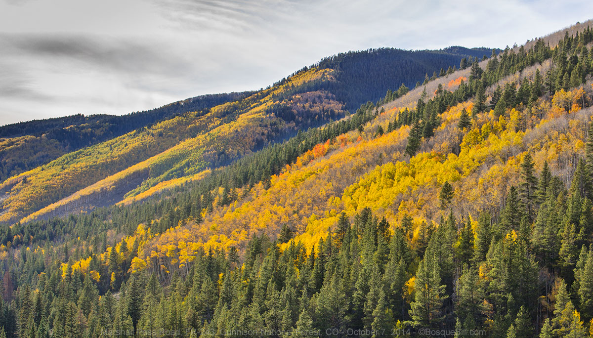
Colorful mountainside 

A patch of brilliant color captured using the telephoto lens.

I obviously like these photos of aspen leaves seen through the white tree trunks.

There were also more deer along here than I'd seen anywhere else on my trip. As the road continued to descend, I passed a few camping areas, but as they were right next to the road, I continued on. The road follows Marshall Creek and then entered into private land. I saw from my map there was a side road heading north, FR-242.2A and tried up that way for camping. There were a couple of nice sites, but they were occupied. There was another far off the road, but not particularly level or pretty, so I continued up the road. There was nothing else and then I hit the boundary line for the Pinnacle Mine, so I turned around and took the one open site I'd seen before. It wasn't as nice as the others I'd had on this trip, but it was getting late and I managed to find a portion of it that was close to level and without too many cow pies.

My campsite off a side road off Marshal Pass Road

Wednesday, October 8th


I still didn't know where I wanted to head from here. I understood that the weather was turning, so generally heading in the direction of home made sense. Marshall Pass Road comes out on US-50, so I could either head east from there to check out the aspen approaching Monarch Pass, then down 285 toward northern NM; or west to either turn south on CO-114 and hence NM: or continue on through Gunnison, then down CO-149 which would take me by Lake City, then south along the Rio Grande. I'd come up 149, named the Silver Thread Byway, earlier in the year and knew it to be a beautiful, scenic drive, plus I thought there might be aspen to view around Lake Cristobal above Lake City. This last idea won the day.

Lake Fork of the Gunnison


I drove through Gunnison, then south on CO-149. The first part of the route is through drier, lower terrain, then it goes up and over and down to along the canyon of the Lake Fork of the Gunnison River. There were some photo opportunities here, mostly cottonwood rather than aspen, but colorful. I noticed a side road dropping down into the canyon and turned around to explore that. It ran next to the river, right up against the canyon wall to the trailhead for Devil's Creek. There was an interesting truss bridge, but I didn't explore farther.

A scenic spot right along the Lake Fork of the Gunnison River near Devil's Creek

Truss bridge across the river just north of the previous photo.

As I was taking photos of the bridge and river I noticed the battery level indicator flashing on my camera. Oops, I hadn't been checking that and I could have easily recharged using my 12v/120v converter the night before. Well, I was almost to Lake City and it was lunchtime, so I would look for a cafe where I could plug in my charger while I had lunch.

Highway to Lake City with Carson Peak in the background

I found the Tic Tock Diner and the nice waitress found an outlet for me to use. I had a Tic Toc burger and by the time I was finished the battery was charged enough to get me through.

The road to Lake San Cristobal, County 30, is a few miles south of Lake City. This is the same road that goes to Cinnamon Pass (closed for the season.) Although slightly augmented by man, Lake San Cristobal was mostly formed by an ancient landslide that blocked off this fork of the Gunnison River.

I pulled in to the north end of the lake for photos. By this time it was between mostly cloudy and overcast, but still very pretty.

Lake San Cristobal and the gathering clouds

I then thought I'd head on up the road to look for more photos and this is where I ran into that adventure I promised.

Predicament


I passed the lake and the wide, dirt road continued along the river. At one point I saw a spot for a photo, but was past it before I could stop. I threw the truck in reverse to back up and get the shot, after checking there was no traffic. I was obviously not careful enough as I ran the two right-side wheels off the road. At that point there was a steep drop of three to four feet to the ground. I put the truck into 4WD and tried to drive out, but that caused me to actually slip father off. I put on the parking break and took a deep breath.

Just then a fellow and his wife came by and stopped in their John Deere ATV. The driver said "Looks like you're in a bit of a predicament." That was an accurate statement! I replied "Do you have any suggestions?" He said that if he'd been in a larger truck he could pull me out. I replied that I had a front hitch that would take a shackle, maybe that would help. His idea then was to pull from the side which might help keep my truck from sliding farther into the ditch. He was concerned that if we messed up my truck would tip over on its side, but I was hopeful this scheme would work. I dug out and installed the shackle mount on the front hitch and found the recovery strap which I'd also had the foresight to carry. We double-doubled up the strap so it would be short enough. He asked if I wanted to take a picture. If he hadn't brought it up I wouldn't have this evidence of my foolishness.

Not a good spot to be in, but at least I had recovery equipment and a good samaritan to help.

The plan was for him to keep tension on the front of my truck at an angle and help pull the front back on the road with the rear following as I eased out in 4WD. It took two failed attempts for me to remember I'd put on the parking brake - do'h. Once I disengaged the brake I was able to easily drive back on the road with the help of the ATV. Whew! Am I ever thankful I'd put on that front hitch earlier this year and bought those very basic recovery accessories. That easily saved me hundreds of dollars and the time and stress of getting a tow truck up there. And thankfully the event did no apparent damage to the tough little Tacoma.

I wasn't going to let that stop me, so took my photo, then drove on up the road for a while longer to see what was there. When I got to the point where clearly there would be no more autumn colors I turned around and drove back to the highway.

Upper Lake Fork of the Gunnison River

Slumgullion Pass – Spring Creek Pass


Continuing southeast on 149 most of the aspen were gone by. I again marveled at the enormous geographical area between Slumgullion Pass and Spring Creek Pass that is utterly decimated by the Spruce Beetle (Dendroctonus rufipennis). There were large groves of aspen in this area, too, whose branches were totally bare of leaves, though I was told later at the ranger station in Creede that the aspen are fine; they had just lost their leaves, probably from a recent wind storm.

The farther south you get from Spring Creek Pass, the less affected the spruce are by the beetles. There are some interesting side roads around the North Clear Creek Falls area, specifically FR-510, 509 and perhaps 532, as well. The views of Bristol Head Peak are magnificent. I do want to come back this way next year and spend a couple of days exploring this area.

Bristol Head seen from the Silver Thread Byway

Creede


I learned the name Bristol Head and about the Spruce Beetle at the ranger station in Creede. I had just driven on by this old mining town on my previous trip up 149 earlier in the year. I drove through downtown this time and saw for the first time the dramatic canyon just north of the village. I asked the nice lady at the station about that, too, and she told me about the scenic loop through the old mining area. She marked it on their vehicle use map, which she gave me, and said the Chamber of Commerce could provide more information ˗ See Bachelor Historic Tour on this page.

You may, or may not, recall that I live near the Rio Grande just outside Albuquerque. The river at home is wide and always muddy, and sometimes barely flows at all. So I enjoy seeing The Rio in its upstream incarnations. Beginning west of Creede, 149 follows the Rio Grande to its end (the route, not the river.) I didn't take photos of Wagon Wheel Gap, where the river and highway, squeeze between the canyon formed by Blue Park and McClelland Mountain, as the light was poor and my photo earlier in the year is still online (scroll down this page if you're interested.)

Palisade of the Rio Grande


Day-use area of Palisade Campground along the Rio Grande

The cliff along the edge of Blue Park is called the Palisade, and on my previous passage, late in the morning, I'd driven through Palisade National Forest campground which is between the highway and the river.

The Palisade for which the campground is named

It was a small, very pretty, wooded campground. I was fascinated that several sites were right next to the clear, rushing Rio Grande and thought at the time that it might be fun to camp there sometime. This would be that time. It was only 4pm, but I'd driven late the day before and if I passed this site there would be no others for many hours.

A campsite along the river, though I ended up choosing another site.

The Rio Grande River seen from my eventual campsite

My campsite seen from where I took the previous image.

There were no other campers, just one family having a picnic gathering, so I had my choice of sites. I chose one, walked around taking photos, them moved to another site with a better view of my river. I felt very lucky for several reasons: the campground was beautiful with views of the Palisades and many cottonwoods and willows in their autumn colors; the campground was indeed still open – it doesn't have a gate, and is low enough in altitude, that I suspect it remains open year around; there were no screaming kids or barking dogs; and as a bonus, the forest service had removed the cash box, so camping was free.

I love vanishing-point photos

An additional “feature” of the campground is a train track running through the middle of it. The first time I saw that I thought, yikes, but as it is only used for the Denver & Rio Grande Scenic Railroad between South Fork and Wagon Wheel Gap, I was not worried about noise. It runs Tuesday through Saturday, but only though October 5th.

An old boxcar used for storage and a maintenance car of some sort.

I was intrigued by the latch on the boxcar door - old school tech.

The tracks leave the campground, headed down river toward the station at South Fork.

I carry a small battery/crank-powered radio which includes the weather radio channels. Most of the time when I'm back in the mountains I cannot pick up a station. As the weather seemed to be closing in, I tried again this evening. I was able to pick up the station for the San Luis Valley to the east. The forecast was for rain tonight and tomorrow with snow at elevations and travel advisories for tomorrow night. So I put aside thoughts of camping in northern New Mexico and planed to head directly for home the next day.

Thursday, October 9th


I woke in the night to the sounds of rain. It was raining in the morning, too, and naturally that was when I ran out of propane in the bottle to which I was connected. The temperature was mild, so I wasn't worried about the furnace, but to be unable to make coffee, that would not do. I waited a few minutes for the rain to lighten up and slipped on my wind breaker, the closest thing I had to a raincoat, and stepped outside to swap the hose to the other bottle. That was the last break in the rain, so I wrapped my cameras up in plastic, gathered everything I needed to move to the cab, and prepared to get wet breaking camp.

Well, the thing about the aluminum camper roof is that it makes a light rain sound like a torrent. I was able to pack up, lower the roof, and hit the road without getting very wet. I knew though that I'd need to raise the camper top at home, when it was dry, to keep mold and mildew from forming on the sides.

South Fork – Homeward Bound


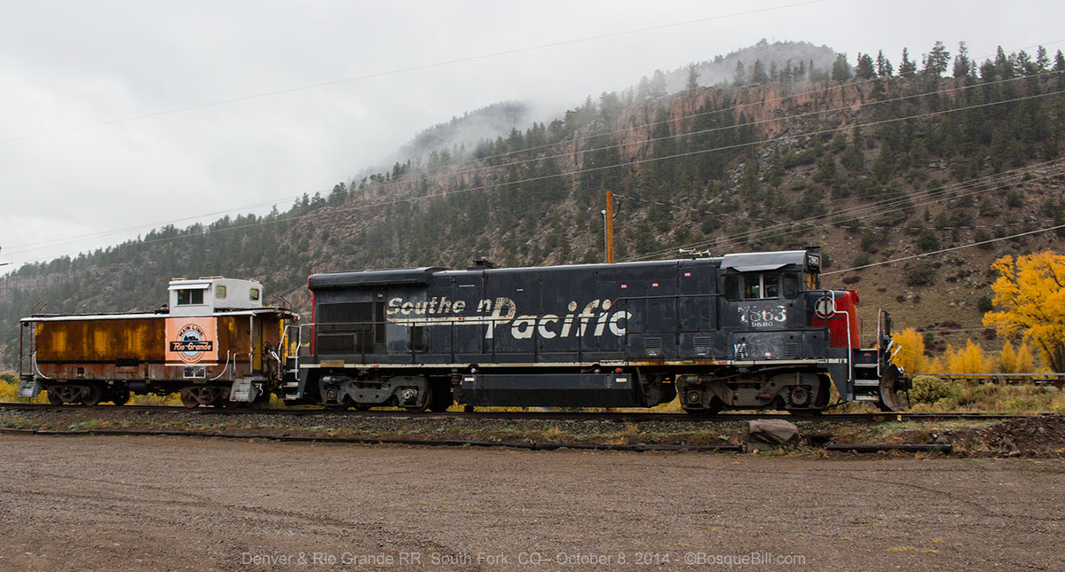
It rained all morning. I stopped briefly in South Fork, the end of the Silver Thread Byway, to take photos out the truck's window of the D&RG RR station to illustrate this blog.

Train station at South Fork

Engine and caboose parked next to the station.

It was still raining in Monte Vista. It was raining on and off by the time I reached Alamosa where I gassed up. It mostly stopped by the time I reached the village of Antonito, where I returned to the Dutch Mill cafe for an early lunch, a.k.a., breakfast.

It was overcast, but mostly dry as I continued south into New Mexico. I looked over to the west to the mountains where I had originally thought to continue camping and it looked like it was pouring down rain there. Turns out that Albuquerque had rain in the area, too, though it was pretty light. When I got home, the driveway was wet, but nothing was falling out of the clouds as I unpacked the truck and camper.

I think this was my most enjoyable camping trip of the year. The scenery was fantastic. The weather was great until the very end. I was lucky in finding good campsites. I had a little adventure that I escaped due to my foresight and even more luck. It's getting late in the season and with other unforeseen events, this might be my last trip for the year. If so, it was a good one. Thanks for coming along after the fact!

In Search of Autumn Color: Colorado

A Narrative in 3 Parts

Colorado, October 2 – 9, 2014


My plan was to head up to SW Colorado on the last Monday in September to look for colorful, fall aspen leaves, but the weather forecast was not good, so I delayed leaving until Thursday.
This turned out to be an excellent decision, as the skies were clear when I arrived in Colorado and there was still photogenic snow at the higher elevations (and some mud and slush, too.) I enjoyed great weather most of the trip, though it got cold at night.

I took lots of photos during this trip, so thought breaking up the narrative and images into three parts made sense for you and for me.

Remember to click on a photo to open them all at a larger size in a viewer window.


Here's my route for the full week, very roughly clockwise in travel - follow the red arrows and colorful legend.

Part 1: October 2nd to the 4th


The first part of my journey took me up though the San Juan Mountains to Owl Creek Pass. From there I headed northwest, passing though Gunnison, to follow a county road along Ohio Creek up to Kebler Pass Road.

Thursday, October 2nd


As I headed northwest through New Mexico, the truck experienced some head winds left over from the storm passing, but luckily they died down after about an hour. I stopped for lunch at Zia Tacqueria in Durango. As I mentioned in earlier blog posts, my neighbors had raved about their fish tacos, which I had indeed found to be delicious. This time I thought I'd try their green chile pork - yummy!

There was some autumn color as I drove into the San Juan Mountains. My destination was Owl Creek Pass. My buddy, Chris, had strongly recommended the area for autumn color. He had shown me his beautiful photos with Chimney Rock, and other interesting formations, as backdrop. As I drove through Silverton I saw that the aspen were far past peak, so I didn't bother checking up Mineral Creek, but continued on.

Approaching Engineer Mountain on US-550. Autumn color is beginning to show.

Owl Creek Pass


I passed through Ouray and Ridgway to turn east on Owl Creek Pass Road on a beautiful, late fall afternoon. I could see Chimney Rock way off to the east. After driving up a wide valley, the route began to climb into the mountains and the road changed from dry & dusty to rocky, and then muddy with patches of snow in those areas that receive lots of shade.

Chimney Rock

Many of the aspen groves were gone by, brown or even leafless, but most were others still green or shifting into yellow. I stopped to take pictures from time to time. The late afternoon light was lovely on Chimney Rock. I drove over the pass and down the other side with the intention of finding a dispersed campsite.

Cold, snowy Owl Creek Pass

I skipped the first road just below the pass, FR-860, as it was too snow covered. This eastern side of the mountain seemed to have more snow, though there were clear stretches, too. As I drove down the mountain I could see colorful aspen west across the valley, but as they were in the shade, I decided to come back this way in the morning.

I checked out one campsite just before the Cimarron River. It was ok, not too muddy, but cold and uninviting. I passed Middle Fork Road, then turned up the East Fork Road. There were folks camped along there and those sites unoccupied were muddy or snow covered. When the road climbed away from the river, I backtracked to Middle Fork Rd. The first site was taken, but the second was not only open, but level and scenic, alongside the river. It was a little muddy, but the ground was at least firm. I set up in the last light of the day with rapidly falling temperatures. (I need to come up with a better mud control protocol for setting up to keep the floor of the camper dry and clean. Perhaps a plastic carpet runner cut to size would do the trick.)

My campsite along the Middle Fork of the Cimarron River with the last rays of sun on the peaks.

Friday, October 3rd


My campsite in the frosty morning

I took a short walk around the area where I'd camped, though the temperature was still cold. It had gotten down to 27Āŗ overnight. It was a nice area and there were a couple of other large dispersed sites just a little farther up the road. After my walk, I drove to the end of Middle Fork Road where there is a trailhead. There was one side road to explore another time, but no other campsites. I turned around at the trailhead.

I then drove back up Owl Creek Pass Road to look at the areas I'd seen the evening before. Such a beautiful area. I also saw the same unpredictable mix of green, yellow, brown and bare aspen groves, many times right next to each other.

FR-860 near Owl Creek Pass

I drove up the road just below the pass in hopes of photographing Chimney Rock from the "morning" side with aspen in the foreground. There were no aspen up this road. I did, however, see my very first moose in the flesh and tried to get a picture as he disappeared into the trees. I turned around where the road goes from unimproved to 4WD only. It was very rocky and my goal this trip was for autumn color, not rough roads.

My very first moose sighting, somewhat out of focus. I was delighted to see this guy!

I took another look at the pass itself, then drove back down. I took a number of photos in the area where FR-858, 861 and 863 converge south of Silver Jack reservoir, though those roads may be numbered differently on different maps. There are many dispersed campsites in these areas.

Owl Creek Pass Road down near the Cimarron River

I then headed north on 858, a.k.a, Big Cimarron Road, named after the river.

At the junction of Owl Creek Pass Road and East Fork Road

Roadside glory

The reservoir and campground was closed, but there were some pretty aspen by the closed, Beaver Lake campground with a little pond farther north - and a gaggle of photographers.

Pond next to Beaver Lake Campground

Such a beautiful scene. I had to include another view.

I decided to continue north along Big Cimarron Road to US-50 rather than staying in the area. As I drove down the road, I passed a number of trucks pulling long, trailers. I bet they were headed for those wide, flat campsites I'd just vacated. Big Cimarron campground was still open, but then the national forest ended in private land.

Ohio Pass


Ranch country along Ohio Creek Road on the way to Ohio Pass in the Anthracite Range.

On reaching US-50, I drove east to Gunnison, then turned north on CO-135. Just a few miles north of town is Ohio Pass Road, to the left, which goes through quite a bit of ranch country, then climbs toward Kebler Pass Road. There were a few photo opportunities along there.

Looking southwest at the West Elk Mountains from near Ohio Pass.

Once I got to Kebler Pass Road, County 12, I took a look at Lake Irwin campground, which I'd missed my last time by here as the road is unmarked. This time I was forewarned, examined the map carefully and found it. A nice forest campground with a pretty lake, but I had aspen on my mind, so moved on.

Lake Irwin, with the campground overlooking the lake. Photo taken crossing the small dam.

Kebler Pass


I headed west, over Kebler Pass, on CO-12. There were a few aspen photo opps and lots of people admiring them. I checked a couple dispersed camping areas, but they were well populated. I didn't want to go too far as I figured the light would be better in the morning for the area I was traveling through. Then I spotted a little, muddy track into an aspen grove with a nice campsite. I set up there in the late afternoon and walked around taking pictures while the light lasted. Luckily the ground in the grove itself wasn't too muddy. It was covered with aspen leaves of all colors.

My campsite in an aspen grove, not far from Anthracite Creek.

A photo using my 300mm lens showing an outcrop of The Dike formation.

Ruby Peak as seen though my 100mm lens.

Saturday, October 4th


I backtracked a few miles to photograph one of the scenes I'd passed last evening.

Anthracite Creek with Ohio Peak in the background.

I continued west on Kebler Pass Road. I enjoyed the scenery much more than my last time when it had been raining and overcast. I took the spur, FR-706, to Lost Lake Campground. I'd hadn't explored that way last time. Another small, pretty campground with a dramatic view of high mountain peaks reflected in the lake. I had a nice chat with a fellow in a VW Westfalia. There were a couple of dispersed sites along the road to the lake close to the main road.

Lost Lake on a glorious morning.

Continuing west on CO-12 there were some spectacular vistas looking across the patchwork color laid upon Snowshoe Mesa with snow covered mountains in the distance. As beautiful as this was to view in person, the photographs were too pedestrian to include here. Hwy 12 drops elevation here and runs along Anthracite Creek (which I later figured out, was the same water as I'd photographed earlier) until it and the creek reach the North Fork of the Gunnison River at CO-133.

The journey continues in the next installment.

Thursday, June 19, 2014

SW Colorado - June 2014 - Part 1


I'm breaking my trip around Southwestern Colorado from June 2nd to June 7th into two parts for easier reading.

Remember you can click on a photo to bring up larger versions of all photos.

SW Colorado Loop (Parts 1 and 2) - Kindly proceed in the counter-clockwise direction.

Monday, June 2, 2014


Fortified with Little Anita's huevos rancheros, I headed north up I-25, took the bypass around Santa Fe, gassed up in EspaƱola and headed north on US-84, left turn at Chama and on to Pagosa Springs.

San Juan River


The San Juan River flows through town and, wow, it was a snow swollen torrent. I stopped at the Forest Service office for maps, brochures, and info. On their recommendation I was going to look for dispersed camping along East Fork Road, which is east of town on US-160.

Through the windshield: San Juan River Valley above Pagosa Springs.

I evidently missed the sign, perhaps distracted by the scene above, as the first place I noticed was the turn for West Fork Road, which I'd noted on the map was farther up the highway than East Fork. I pulled over to check the map and realized I was close to Treasure Falls. The fellow at the ranger station said the trail was steep, but only a quarter mile long. I'd go there first, then decide what to do for camping. Very nice little falls and the trail was as described. You can get right up close to the bottom of the falls if you want to get drenched (which I did not as I didn't think my camera would like that at all.)

Treasure Falls as seen from the highway pull-out.

Closer view of the upper falls.

West Fork of the San Juan River


I turned in on West Fork Road and looked over the official campground. It was nice enough, but I thought I'd check up the road for dispersed opportunities. I found a cool spot right beside the West Fork of the San Juan which was roaring!

My campsite along the West Fork of the San Juan.
Photo taken from the one-lane bridge I crossed to get there.

There were a few mosquitoes, which had me concerned at first, but they turned out not be much of a problem as they were not hungry enough to try and poke through my shirt or pants. There were several other spots for camping past the bridge, FYI, and nice wildflowers in the woods.

Shooting Star Columbine. This species was prevelant almost everywhere I camped this trip.

Tuesday


After leaving my camp and heading back up US-160, I stopped at the scenic overlook.

Looking back (south) toward the West Fork.
The dirt road at the bottom of the photo was the one taken to my campsite.
You may also recognized the rock formation of the first photo above.

I then proceeded up through Wolf Creek Pass and down again. I turned north on CO-149 toward Gunnison at the town of Halfway. The highway along here runs beside the Rio Grande. It is a beautiful area and many folks have built here.

Upper Rio Grande Valley


Looking downstream toward Wagon Wheel Gap

I spotted an interesting forest road climbing a hill, FS 600, so drove up to get a flavor of the land. There were interesting canyon walls and the great views of the valley. I stopped part way up and walked along the ridge.

Looking upstream (westerly) - the Upper Rio Grande Valley.

The highway continues to follow the Rio Grande for quite a ways, then climbs away. This highway is part of the Silver Thread Byway. After crossing a few small passes, I thought I recognized the east side of Red Mountain, between Silverton and Ouray. Sure enough, when I pulled up to the scenic overlook, the signage did in fact identify it as such.

Panorama from the overlook above Lake City

The highway drops down and passes through Lake City which has a "resort" and tourist feel to it. Lake City is also the terminus for two 4WD trails of note, Engineer Pass and Cinnamon Pass. Both connect to the Ouray/Silverton area and are rated "easy" on their east ends and "moderate" to the west.

Following the Lake Fork of the Gunnison River brought me to the long reservoir which is part of the Curecanti NRA. I turned east on US-50 toward Gunnison.

Gunnison Basin


I stopped at the National Forest office and bought a map of the Gunnison Basin area which includes the National Forest and BLM lands there about. The gentleman there didn't have much to add, so I headed over to the BLM office and the young woman there was extremely helpful. She was happy to spend as much time as I needed to explain places to camp, things to see, etc. One of the places I wanted to find was an idyllic campsite up an undeveloped road that I'd found back around 1973 - a gorgeous area with beaver dams and glorious scenery. From my ancient description of the road I thought I'd taken, she gave me her best guess on where I should look, so I headed north on CO-135 to Crested Butte.

Through the windshield: Crested Butte
I passed through the town, which is known for its ski resort, and headed up the road she suggested, 734. It was quickly apparent this was not the area I'd been in before, but the scenery was spectacular and I drove on.

View from Slate River Road

There were a few dispersed campsites way up the road, once you get past the private land. There was also a BLM campground, "Oh Be Joyful". There were a couple of undeveloped roads that turned west, but you needed to ford the Slate River to get to those - not advisable with the river roaring from snow melt. I decided not to camp up there, both as it was still early in the day and at that high elevation, well over 10,000 feet, I bet it would get very cold at night.

Alpine wildflowers

So, I reversed course, passed back through Crested Butte, then took Jack's Cabin Cutoff road to the Taylor River and drove up CO-742 toward Taylor Park. This is a beautiful highway with many campgrounds along the river, but no dispersed camping until you are past the lake.

Taylor Park


Once I was at the Taylor Reservoir I took 55, then 752 to look for dispersed camping. These backroads were slow going and I couldn't find a spot that pleased me. Seems to be an area popular with hunters and the ATV crowd. By the time I wound my way back down and out to the highway I was tired and frustrated and it was getting to be late in the day.

I saw from the map there was a campground at the north end of the lake. I told myself if I didn't find a dispersed spot before I got there I would pay for the campground. I didn't, so I pulled into the USFS River's End Campground. There were only a few people there, so was able to find a spot off to myself and tired as I was, it was nice to have a level spot with no prep needed. It turned out to be a beautiful evening and I took a number of photos.

My campsite with Taylor Reservoir in the background.

My campsite looking at the view in the other direction.
Taylor Reservoir later in the evening.

And again at sunset.

One of the things I'd wanted to try this trip was star photography, so even though I was close to exhaustion, I got out my tripod once it got good and dark. It was windy and very cold. I had some issues with the camera that only another photographer would understand, so won't go into those. Let's say I gave it my best shot and crossed my fingers that when I got home and put the images on the computer, something would turn out. I took a series of 30 second exposures in the hope to stack them to create star trails.

Starry night above the Sawatch Range. One exposure.

My photo sequence didn't come out as well as I hoped, so used Photoshop
and one exposure to create this fun star trails image.
It is post processed, but based upon the actual stars photographed that night.

Wednesday


It felt like it got cold overnight, but when I went to check my wireless indoor/outdoor thermometer I discovered the outdoor transponder's battery had died during the night. When the campground host came around in the morning (the fee deposit slot had been taped shut when I came in) she said it had gotten down to 20 degrees overnight. That explained the ice in my grey water bucket!

Taylor River Valley


After breaking camp I continued north up 742, the Taylor River Road. There are a few residences within the first half mile of the campground, then the road is within the Gunnison National Forest, and in another half mile there is a side road leading toward the river where there is dispersed camping. And then another side road and another. Lots and lots of beautiful campsites, not right on the river as the regulations are that there is no camping within 100' of the river, though at some sites those feet are pretty small.

I started to feel foolish for staying in the campground the night before, but then I realized that I'd gotten my $7 worth (discounted fee) simply in my conversation with the campground host who gave me the weather report, told me about the four moose that had been seen a couple of times in the willows near the junction to Cottonwood Pass, about the herds of elk frequently seen in the valley, and confirmation of road conditions (Spring Creek Rd was closed due to rock slides in two places, so I would not be able to loop back toward Gunnison via that route, but backtrack instead). Plus, I now realize I got lots of photos that I like from that spot, too. A bargain.

Taylor River Valley

The Taylor River Valley is quite lovely and certainly scenic. There is grass and willows along the river, but the valley floor is mostly brush. The conifers march down from the shoulders of the mountains, but stay along the valley margins for the most part. The mountain peaks were still snow covered and provided a grand background to the scene. Those peaks are of the Sawatch Mountain Range and the Continental Divide runs along their crests.

More alpine wildflowers.

As I drove up the valley I was surprised I didn't see anyone fishing in the river. Perhaps it is just too early what with the river swollen with snow melt. There were a couple of "pot hole" lakes up the valley and I spotted one fisherman there.

There are a couple of official campgrounds along the route, for those who want those amenities. I continued up the road until I reached the old Dorchester Cabin - all that's left of the town of Dorchester.

Dorchester Cabin.

I returned the way I came, stopping at the scenic overlook at the lake.

The Sawatch Range reflected in Taylor Reservoir.

I returned to Gunnison. While getting gas I asked a fellow patron where a good place for lunch could be found. She said the Gunny Sack on N. Main Street was her favorite, but you couldn't really go wrong at any of the places in the first two blocks north of Tomichi (US-50.) I tried her favorite and ordered one of their specialty burgers and was very pleased and very full.

After lunch I headed west on US-50 with a destination of the Black Canyon of the Gunnison National Park. A photographer friend of mine said the Black Canyon was a spectacular place, but he'd never found a way to photograph it to do it justice.

Crazy drive that afternoon. Lots of freeze damage to the highway and some trucks carrying humongous tanks that took up two lanes. I thought I'd missed the turn-off to the park, but it is just much closer to Montrose than I'd thought.

Black Canyon of the Gunnison National Park


I checked out the campground at Black Canyon, though it was still too early to camp. It was pretty nice. There is vegetation screening many of the sites from one another, especially in the non-reservation, Loop C. Not a bad place to camp if your itinerary places you there late in the day.

Black Canyon was indeed amazing and these photos don't do it justice.

Looking upstream from near the Visitor Center

Look carefully - you can see the river along the canyon bottom.
The light didn't provide enough contrast to make it easy to understand you're looking
down the canyon, and not simply at the canyon wall on the other side.

Looking downstream toward the end of the canyon and Montrose.

The rock at the bottom of the photo is at my feet.
The rest are way, way down.

Obligatory wildflower photo from along the canyon rim.

End of Part 1 of 2