Showing posts with label The Notch. Show all posts

Friday, June 28, 2019

SW Colorado & SE Utah - June 2019; Part 4

Part 1 of this trip begins here.


Continued from Part 3

Part 4: North Cottonwood Road; Gooseberry Road; Elk Ridge Road; The Notch; Horse Pasture Trail; Cottonwood Road


Don't forget you can click on any photo to see a larger version.

Friday, June 7th (continued)


One of the (many) confusions of nomenclature I'd had with this whole area was there being a Cottonwood Canyon/Road/Creek on both sides of the mountain. I thought for a while this could be explained as both canyons met at a saddle near this junction, but they don't actually, though both roads do almost meet here. Unrelated to this trip, but on the subject of duplicate place names - there's a Butler Wash between Beef Basin and Canyonlands, and a Butler Wash east of Comb Ridge near Bluff - sigh. (I've rewritten the paragraph several times as my understanding continues to evolve. Let me know if you think I've still got it wrong.)

Stevens Canyon


North Cottonwood Road goes all the way through to Bridger Jack Road with that junction being only about 5 miles south of the highway to Canyonlands Needles District, UT-211. I did not plan to go the whole way, but wanted to get an idea of what it was like. I kept my eyes peeled for possible camping spots and found an interesting one not far from a small, nameless pond about two miles north of Causeway Road. It looked pretty good, but I wanted to look around a bit more before settling in for the evening.

A little pond and interesting sandstone formations.

Looking down the side road, FR-97, that leads to the northern Mormon Pasture

Spherical Panorama above FR-0097 (click the Full-screen icon [ ] for best view:


The road dropped out of the Ponderosa zone quickly, passing a spur leading to the north Mormon Pasture and another to the South Mormon Pasture and an airstrip. Then the road wound along the east rim of Stevens Canyon with steep rock walls. I stopped for photos. The road was narrow and there were no dispersed campsites in the portion of the canyon area I drove.

Standing on the rim of Stevens Canyon looking back at those sandstone formations.

Looking the other direction.

Last view looking north along Stevens Canyon.

I turned around and headed back up. I set up camp in the spot I found earlier. It turned out to be even prettier than I'd initially thought as there was a lovely view north, across the meadow, with some interesting sandstone formations in the distance and a number of old Ponderosa pines with character. The evening was very mild, so I sat in my chair relaxing with the view. And although the wind had abated somewhat, my camp was nicely sheltered by evergreens.

My campsite with a very pleasant view.

Saturday, June 8


My plan for the day would be to drive west to Gooseberry Road, then south. I wanted to revisit The Notch that so impressed us when my friend Dan and I had drive through the year before. (That blog post). I wanted to get aerial views. The sky was clear and wind light, so I wanted to get there before those conditions changed. I thought I'd also visit the Little Notch; the lady at the ranger station mentioned the Hammond Canyon Trail might be a good hike for me. Then I'd return north, perhaps exploring Deadman Point and the Horse Pasture Trail. If I found a better campsite I'd grab it, otherwise I'd return to my nice spot off North Cottonwood Road as it was only a couple of miles from Cottonwood Road where I planned to descend toward civilization the next day.

First thing, I had to figure out what bird that was vocalizing almost constantly around my campsite. I knew I'd heard the song before, but couldn't place it. Some kind of vireo? I spent way too much time trying to get a glimpse and capture a diagnostic photo. Finally. Not a great photo by any means, but clearing showing the field marks of a Plumbeous Vireo. Yeah! I also got photos of bugs and flowers this beautiful morning.

There's the little guy - singing his heart out.

Looking back at my campsite. Can you see it? Look just to the right of the big pine.

A field full of Dandelions.

Time for an eye exam? At first I thought these were eggs some exotic critter had laid on the rock.

Bug love

Gooseberry Road


On the drive back to Causeway Road, which some maps call Lime Creek Road along here, I spotted folks camped about a mile from me, up a small hill. Those were the only other campers I saw all weekend and far enough away from my camp I never heard them.

I turned south on Gooseberry Road which was not in bad condition generally, but did have a number of shallow washouts and mud holes. Most of the side roads off Gooseberry were very muddy and seemingly impassible. I wondered about this, then after seeing those areas where sheets of rock were exposed, I realized the soil was not deep and the rock likely prevented water from percolating down and away.

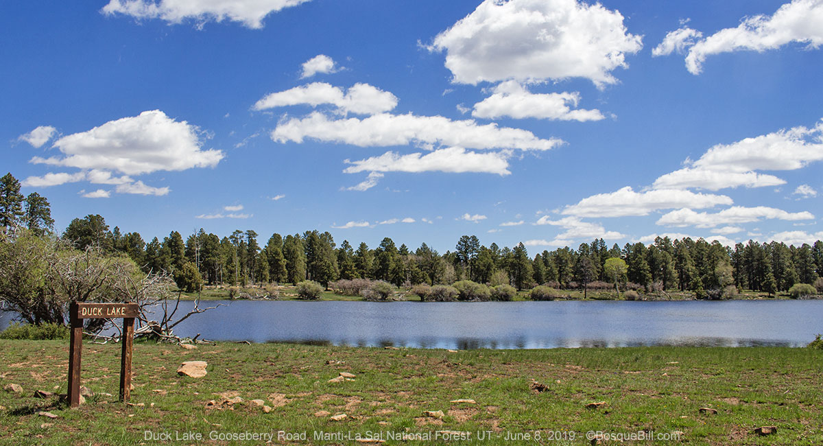
Duck Lake features actual water this year!

Duck Lake certainly had more water in it than last time I'd seen it.

The Notch


There was one long mud puddle before descending into The Notch. I dropped into 4WD just in case. It was a little squirmy, but not bad. I got there around noon and the weather was mostly cooperating. The Notch is a saddle along Gooseberry Road, or perhaps this section is now Elk Ridge Road (it's hard to keep track as signs are few and maps inconsistent.) On the east side is Notch Canyon, below Notch Peak, with a view toward Abajo Peak. On the west side is an arm of Dark Canyon.

The Notch. Notch Canyon with the Blues in the distance.

Spherical Panorama of The Notch and Dark Canyon (click the Full-screen icon [ ] for best view:


As the road climbed south from The Notch I stopped for this photo of Dark Canyon.

Little Notch


I proceeded south to the Little Notch, which is really a part of the road that overlooks Hammond Canyon with the Abajo Peaks in the background. I took some aerial photos to see the portions of the canyon which are hidden by trees near the road.

Aerial view of the Little Notch, Hammond Canyon, and the Abajos.

Spherical Panorama from above the Little Notch showing the Hammond Canyon complex (click the Full-screen icon [ ] for best view:


Hammond Canyon


The road to the Hammond Canyon Trail is less than a mile north of the Little Notch. The trailhead is only a hundred yards or so east of the main road. I also discovered that there was evidence of people camping at the trailhead, but if you follow the road about 50 feet farther there is a great campsite. This site has a view of Hammond Canyon and the Abajos through the trees. I'll come back here another time.

I parked near the trailhead, gathered my lunch, and set off down the trail. The first section of the trail is a gentle downslope through the trees. It looks like an easy route down into the canyon through a wooded side canyon, no telling how technical it gets farther down. It was a lovely day.

Unfortunately, I didn't get very far before experiencing tachycardia - a symptom of my paroxysmal atrial fibrillation. Mine is not serious, or life threatening, and I am under a doctor's care and taking the appropriate meds. However, it probably is not wise to undertake a vigorous hike during an episode. Fortunately, I was at the part of the trail still on the ridge before it drops into the canyon, and there was a very convenient log in the shade overlooking the canyon and mountain peaks. Excellent.

The gorgeous view from my picnic spot.

I sat myself down to enjoy the spectacular view. Don't remember why I pulled my phone out, but found I had a strong cell connection with LTE data, too. So I thought I'd give my best friend in Austin a call. He happened to be at home with no pressing duties and we had a great chat. During the call my heart returned to normal and I was able to enjoy lunch, the view, and ambled back to my truck.

The Notch Reprise 


I turned back north on Gooseberry or Elk Ridge Road, I guess. I stopped again at The Notch to try to capture the scene with light later in the day - the weather was still cooperating. I also stopped a bit farther north where there is a better view of Dark Canyon, but the sun was too far west for that to be ideal.

Aerial View of Notch Canyon

Dark Canyon as seen from Gooseberry Road

Deadman Point and Horse Pasture Trail


I wanted to look at the Horse Pasture trail I'd learned about at the ranger station, so turned at the sign pointing to Deadman Point. Oh, boy! Lots of mud puddles, some pretty soft, so I stayed in 4WD. After a while I came upon the trailhead and parked. It looked like the trail stayed along the rim for a ways, so thought I'd give it a try (remembering to bring my satellite communicator.) The trail did indeed stay on the rim for about three quarters of a mile crossing small meadows and through Aspen and Ponderosa. I'd been monitoring my heart rate via the hiking app on my watch and all was normal and fine. It was a very nice little hike.

I realize now, that although I was carrying my camera gear, I didn't take any photos along the trail. In part because I kept thinking the trees would thin and I'd get a photo of Dark Canyon, but they never did. I thought I saw a cougar print in the mud; I was going to take a picture on my way back, but couldn't find it again. Oh, well, you will just have to use your imagination. For those interested, the trail dropped into the canyon through a wooded side canyon and at least the first section didn't look technical.

On returning to the truck I decided not to try the road farther out to the point, as poor condition as it had been coming this far. On the way back to Gooseberry I thought I'd try an alternate road back that looked higher and drier. That was almost a very bad decision. Yes, for the most part it was drier, but there was one section about 50' long that was extremely muddy - no puddles, just thick, sloppy mud. I should have stopped and gone back the other way, but instead charged ahead. I made it through, but it was a near thing. I got back to the "main" road and headed back to my campsite of the night before.

North Cottonwood Road


Spherical Panorama from above my campsite (click the Full-screen icon [ ] for best view:


And again a beautiful evening at the head of North Cottonwood Road. I was happy and content with my trip despite (or because of) the change in my original plans. I drank a toast to this beautiful land, and  gave a nod to my friend Dan in California - we'd shared a celebratory whiskey on the last night of our joint trip after several great days in Bears Ears NM last year. [Dan, I bought a small silicone ice tray since our trip. Gotta tell you Jack on the rocks is much more civilized than the lukewarm water we had available ;-) ]

A toast to my lovely campsite.

Sunday, June 9


Cottonwood Canyon


I broke camp with alacrity. It was very chilly and windy this morning. A cold front had blown in strongly from the north overnight and I had no interest in lingering.

I mentioned earlier my confusion between the two Cottonwood Roads/Canyons. (In fact I used to believe that what I now know is actually Elk Mountain Road was Cottonwood Road.) Anyhow after talking with the local I'd met on the Causeway Road on Friday, I hoped I was straightened out. I told him the lady at the ranger station didn't like Cottonwood Road. He was puzzled by that as he said it was "the best maintained road" on the mountain. He said it was the road the county used to bring equipment up to maintain all the other county roads in the area. "The county grades all the roads once a year," he said. This year, however, "it snowed twice after they graded Cottonwood Road" and "the bear hunters tore it all up." I was to see that for myself soon.

He also said "Cottonwood Road has 18 water crossings. Yes, I counted." "One time I drove all the way down, but the last crossing was too deep, so had to drive back up and take another road off the mountain." He embellished that story by recounting a Tundra 4x4 had come through before him and the driver said the water came up to his windshield, but he made it. Tall tale? Maybe, but gave me pause.

So, I started down Cottonwood Canyon with some trepidation. The first several miles were unexceptional Ponderosa forest which gave way to piñon then cottonwood as it descended. Miles and miles of the middle section was the "torn up" part. There were deep trenches (tire ruts) running down the middle of the road. The clay had dried and baked into concrete. It took constant attention to drive between the ruts. As deep as the ruts were, putting a wheel in the trench at any speed could well break a wheel or axle. I should have taken a photo, but didn't think of it at the time. I also should have taken a photo of at least one of the water crossings, but was too focused on crossing, not sightseeing. Sorry.

And yes, I started counting the water crossings. The water wasn't deep and the stream bottoms were gravel. After crossing several and noting the water wasn't getting appreciably deeper, I was feeling better. Much of the middle section of the road crosses Mountain Ute tribal lands and is posted "Keep Out." There wasn't much in the way of a view the whole way down - perhaps this is what the lady at the ranger station was referring to. Once I got lower down I tried to find a view looking back the way I'd come.

Looking back up Cottonwood Canyon

Wildflowers along the road.

I came to what by my count was water crossing number 17 and OMG! It was many times wider than all the others. They'd been 3 or 4' wide; this was easily 20 feet or so. It looked deep. Perhaps I should have stopped taken off my boots and checked just how deep, but I guess I thought "what the hell", dropped into 4WD and went for it. There was a moment of "Did I just make a big mistake?" in the middle. (Did you ever see that movie Dante's Peak? Remember the scene where our hero volcanologist and the beautiful town mayor have to drive across the river to try and rescue her kids from the erupting volcano? There was an underwater camera showing the the tires trying to get traction in the rocks on the river bottom. This wasn't that deep, but I heard that same sound of river rocks shifting under my tires.) All I could do at that point was to keep my foot down and power on through. My trusty Tacoma made it!

Nearing the southern end  of Cottonwood Road.

Soon after that Cottonwood Road joined Elk Mountain Road, which is wide and gravel. There was one more water crossing (number 18) before meeting up with the highway west of Blanding.

Looking to the northwest from Elk Mountain Road

Bluff


I drove into Bluff to have lunch at Twin Rocks Cafe at the east edge of town. I had "Bluff's Best Breakfast Burrito." It was huge and delicious. There must have been at least four large scrambled eggs inside, plus all the goodies such as onions and peppers with green chile sauce on top. I had to box up the last half to bring home.

By-pass


For those following along, I found the last leg of the route that would allow me to by-pass Shiprock, Farmington, Bloomfield, and all the awful traffic between. I'd previously established the route that by-passes half of Farmington and Bloomfield. This new section of road is BIA-36 which runs from US-491 south of Shiprock to NM-391 south of Farmington. It is a good quality asphalt highway passing through the Navajo Reservation. There are no services along here, so if you need gas or want a large Slurpee, then stay on US-64. There were native vendors on 371 between 36 and the rest of the by-pass. I almost drove by, but when I saw the hand-painted sign "Roasted Corn" I pulled over. It was sweet and yummy!

As I mentioned previously, to complete the by-pass, go south on NM-371 to NM-302, a.k.a., County 7100, then at the stop sign turn left on 7010 which goes all the way to US-550. It sounds more complicated than it is. If you're contemplating the route to miss all that miserable traffic on 64, check a map to get yourself oriented.

And Home


Thanks for reading along. I hope you enjoyed the trip.

Monday, June 11, 2018

Ruins & Landscapes, UT & CO; Part 1 - May 2018


May 14 - 18, 2018


Part 1: Bears Ears


This May I had the opportunity to meet up with my friend Dan, who was one of the driver/participants in last year's great White Rim Trail expedition. He had little experience on Cedar Mesa and environs, so was interested in exploring. I did some research and planned a route up Bears Ears along Elk Ridge with a visit to Beef Basin, that Cayuse, of Wander the West and WRT fame, recommended. From there we'd loop around, perhaps drive Montezuma Canyon that someone, I forget who, recommended. Hovenweep National Monument was near there, too. From there I wanted to check out two other areas I'd not been to: Canyons of the Ancients National Monument and Dolores Canyon (I'd seen a photograph that made the area seem spectacular.)

I would meet Dan late Monday afternoon at Cedar Mesa. I gave him detailed directions to my favorite dispersed camping spot in the area. He would arrive there on Sunday, try to find a good camp site for us, and do some hiking on Monday and visit Muley Point. He and I both have inReach satellite communicators and he messaged me on Sunday that he was able to grab my favorite camp site and would mark it has occupied while he was away during the day. Excellent.

A few days before I left I got a Camping World sale brochure. I noticed they hade a couple models of propane campfires on sale. I thought that would be handy to have along this trip. On the WRT Cayuse had one and it was almost as much fun as sitting around a real campfire while enjoying a beverage and the telling of tales, and without dodging smoke and without the worries of making sure the fire was dead-out at the end of the evening. I bought the Little Red Campfire™ (and tested it before setting out).

Don't forget to click on any photo for a larger version (strongly recommended.)

Monday, May 14


I set off Monday morning, not too early, headed up US-550 toward the Four Corners. I stopped for lunch at El Bruno's (recommended) in Cuba, NM. It is only about 6 hours driving time from home to Cedar Mesa, so I arranged it so I'd have a little time to stop at Teec Nos Pos Trading Post in Arizona. I wanted to find a little Navajo rug on which to display some of my NM pueblo pottery. I also wanted to stop at Blanding both for gas and to check the visitor center there for info on Beef Basin.

Teec Nos Pos


I did stop at the trading post, but they didn't have any of the sizes I was looking for - a size they call "runners" which would fit the tops of the chests where my pottery was on display. Well, they did have one, but it had a purple color that I could not abide. I did purchase one small rug with a pleasing, colorful design that I thought was not too "busy" as to distract from my pottery. (As it turns out, once I got it home I decided it was much to pretty to cover up with pottery, so simply have it on display now.)

Beautiful little rug purchased at Teec Not Pos Trading Post

I'd driven from Shiprock on US-64 which joins US-160 at Teec Nos Pos. I continued on 160 to Red Mesa where I turned north toward Utah on IR-35. This route is more direct and, I think, more interesting than the more trafficked highways. It's easy to find from the south at the junction just west of the Four Corners Regional Health Center; it's tricker to find from Montezuma Creek - you must follow Center Street past the Post Office, cross the San Juan River, then take a left on the unmarked Red Mesa Road. The road passes on the left side of the hill then turns south.

Blanding


I had called the Blanding Visitor Center the week before to ask if they had info on Beef Basin and they assured me they did. The reality was a bit different. The map the man I'd talked to said was the best, didn't really cover the area, and the lady there on this day did not have any ideas on the area beyond some 7.5 minute topo maps they had. There was only one of those in stock and it only covered part of the basin, but bought it anyway. I got gas at the "unattended" station near the visitor center and set out for Cedar Mesa via UT-95.

North Mule Canyon


"Twins" set up in one of my favorite campsites of all time.

It was a good moment spotting Dan's ATC and Tacoma at the camp site. I backed in next to his rig. As it got toward evening I got out my new propane campfire and set it up. I also set up a camera to take a time lapse sequence of the night sky - it was close to the new moon so should be dark enough to see the Milky Way. I'd researched times and directions using the Photo Pills phone app (recommended), and brought along an intervalometer as my camera did not have those functions built in.

The Little Red Campfire was a success. We sat around it catching up and admiring the dazzling star filled sky. One regret was that I never thought to set up a shot of us and the little campfire - that would have been a nice addition to the blog illustrating one of the pleasant moments of the trip.

Star Time Lapse


I took a couple test shots of the sky, set a delayed start up in the intervalometer and pushed go. Later Dan asked how many shots the camera would take and I suddenly realized I had not changed that parameter after testing the device! Thank goodness for his question or the night would have been a bust with only 5 images. I set the counter for 399, the maximum, but didn't really know how long the battery would last.

The result:


Use this link if you wish to view on YouTube in 1080p:
Night Sky over Cedar Mesa, UT

Tuesday, May 15


Cedar Mesa (continued)


I delayed checking my camera until after breakfast and my first cup of coffee. No need to rush if it was bad news :-) Turns out it was not bad news. Yes, the battery had died somewhere between 200 and 300 images, but using my Hoodman loop the photos looked OK. I don't usually bring my laptop on trips a week or shorter, but did this time so I could download and examine the photos, if I wanted.

Morning at the campsite.

Dan and I broke camp and headed west on UT-95 toward Natural Bridges. Elk Ridge Road, that leads up between the two Bears Ears peaks is the first right after the turn off to the national monument. We stopped part way up to photograph some of the great views.

Looking off toward Natural Bridges. Note also the ripples in the mudstone in the foreground.

Bears Ears


[Warning: The entire length of the route described below, up to the junction of Beef Basin Road is impassible in wet weather. You can see the solidified ruts of folks who were up to their axles in clay along the road.]

We also stopped at the pull-out at Bears Ears pass for more photos. There we met a couple on electric mountain bikes, of all things. On the way up we passed from piñon/juniper forest to pines. Once over the top, at this higher elevation, there were spruce, fir, and aspen.

Looking in a southerly direction from Bears Ears Pass

Looking toward the north from Bears Ears Pass

Looking back at the Bears Ears from a couple miles north.

South Elk Ridge


We proceded along Elk Ridge and stopped at Arch Canyon overlook, but the haze combined with looking into the morning sun rendered the view less than spectacular.

Arch Canyon Overlook. That little bump on the horizon (right) is Ship Rock.

We turned up FR-088 to the north. I had come this far on a previous trip, on that trip I kept going straight which took me to the Cottonwood Access Road on UT-95 not far from Blanding. We continued though the forest, but shortly came to an area called "Little Notch", which overlooked Hammond Canyon, and we stopped for photos.

View toward Abajo Peak across the Little Notch

Before driving on I looked again at my forest service map. Areas of the Dark Canyon Wilderness were on our left. A couple years ago I had asked at the FSDO about the road conditions driving down FR-89 into the canyon. They asked what I was driving and in response they said, "Well, you can drive down..." with the implication, that I wouldn't be able to drive back out. We wouldn't be attempting such a thing today. I saw some side roads on the map ahead where we might find a good lunch spot. I also saw a map feature called "The Notch." Something to look forward to seeing.

The Notch


[Caution: there are warning signs to discourage bringing trailers or large vehicles in this stretch of the road. A high-clearance vehicle is not necessary for skilled drivers, but recommended.]

There was a long, straight descent along the northern side of the mountain with dramatic views of the sandstone canyons, the eastern-most reach of Dark Canyon. Then we came to The Notch where Dark Canyon nearly meets Notch Canyon on the east. (There is also a Notch Peak north of The Notch - a bit confusing.) Wow! Great views. Great photo op, though nothing compares to looking out across the landscape with ones own eyes.

Looking back (south) at The Notch and the road descending to the pass.

Looking toward the west and Dark Canyon from The Notch area.

Looking easterly across the notch at Abajo Peak.

Looking back at the road where it climbs up from The Notch on the north side.

Photo stop where we took photos, such as the one just below.

Looking west into Dark Canyon.

Shortly after climbing back out of The Notch we turned on a side road to find a place for a picnic lunch. At first I wanted to find a spot with a view of Dark Canyon, but as the road quickly deteriorated, we "settled" for a lovely little meadow for our repast. I should have taken a photo, but forgot to do so.

North Elk Ridge


Somewhere along here the forest road name changes to Gooseberry Road. We stopped briefly at the closed access road to Gooseberry Guard Station to look at the info kiosk there and to use the vault toilet.

A few miles farther along, although still at a high elevation, the amount of vegetation drops significantly - lower amounts of rain and snow, I speculate - and the red-rock sides of the mountains become more pronounced. And an additional few miles brought us to the junction of FR-93 that drops down into Beef Basin.

Beef Basin Road


Beef Basin Road begins innocently enough. We stopped at a hairpin curve where there was room to pull over and wide open views to the north and east. Not far past here you leave Manti-La Sal NF and enter BLM lands (with a few sections administered by the state of Utah.)

View of the La Sal Mountains, east of Moab, from the hairpin curve.

Looking roughly toward Beef Basin from the hairpin curve.

Here we are, preparing to explore Beef Basin

[Warning: proceed beyond this point only with high-clearance, four wheel drive vehicles. 4LO is not required, but helped with traction in a few places.] 

Past the hairpin curve, the road begins dropping and the surface includes large rocks to navigate around or over interspersed with fairly level gravel road. On the second, longer descent stretch, down into the basin, we did stop a couple times to scout our path, not that the road was too technical, but from inside the truck it was impossible to see how much drop there was on the far side of some of those rocks and ledges. We made it down with a few mud flap drags and nothing worse.

Part of the way down to the basin we stopped to scout the road and take a photo or two.

Beef Basin


Once down in the basin we came upon a junction and had to stop to figure out where we were and where we wanted to go. As I may have mentioned, detailed information on the roads in the basin was sparse. The national forest map does show some of this area, but not in detail. I couldn't figure out how to apply the 7.5 min topo map I'd purchased in Blanding as it had no road names or numbers. I'd copied a number of maps from the BLM website and put them on my iPad - they were the most detailed for roads, marking those that were "maintained", but I couldn't exactly place us on those either.

This photo is out of sequence - taken on our way out, but illustrates the junction.
You'd think that information board would contain a "You are here" map, but it doesn't.

[Note: Google Maps solves this conundrum by labelling every road in Big Basin as "Big Basin Road" - not the most helpful, IMHO. Now that I'm home and have driven the big loop, the 7.5 min Topo map makes much more sense.]

The resource that 'saved the day' was my Avenza Maps iPhone app (also available for Android phones)  and the USGS topo map Quads I'd downloaded into the app before leaving home. Yea, foresight! This free app displays GPS-enabled maps, shows you which of the maps you've downloaded you are on, and then shows you precisely (within the accuracy of your phone GPS) where you are on that map. As soon as I remembered to open that app, we were able to see exactly where we were and figure out which way we wanted to go. USGS Quads, many USFS and some NPS maps are free to download. There are many commercial and other governmental maps available for purchase. Cheapskate that I am, I only have the free maps, plus I prefer USFS paper maps - though I have to admit the GPS-enabled function is mighty handy.

This was my first time in Beef Basin and mostly I knew that Bob thought this area was beautiful and interesting with many ruins. Perhaps I should have asked more questions about where to go. A few of the maps had "ruins" marked in ambiguous locations, but nothing obvious. Anyway, I thought a good first survey of the basin would be to take what I'm calling the 'big loop' to orient ourselves for a future trip when we had more time to explore. It looked like the southern leg might have dispersed camping spots as it was closer to the edge of the basin. Dan was willing to follow my lead.

We turned left at that first "major" junction toward Stanley Spring. The road to the right (north) leads to Ruin Park and the back way into the Needles District via Scotty's Hole (suitable only for modified 4WD and rock-climber vehicles) and to other back areas.

After another descent, we turned right to start around the big loop, counter-clockwise. Very quickly we came upon a fork in the road. Bear right for the big loop; left for what I'm going to call Beef Basin Spring Road which leads to the intersection of the return loop and Ruin Canyon Road (although I didn't know that at the time). We took the right fork. The northern, and especially western, legs of the loop were a little bumpy with expansive, yet unremarkable views and little opportunity to pull over - so no photos. No good dispersed camping spots on the north or west, either.

When we reached a junction at the southwest corner of the loop (the loop is sort of rectangular, thus corners) I stopped and looked at the topo map. Left would continue the loop, right went for some ways before ending who-knows-where, and ahead looked like a short spur that might offer a camping spot.

South Springs Camping Area


Looking at the campsite from near the campfire/lounge area

Indeed, the short road lead to a very nice dispersed camping area and ended. There was room for our two campers, and maybe one or two more had they been along, among the piñons. We did have to jockey a bit to find close to level. There was also a fire ring/seating area with a very pleasant view of the basin. "Behind" the camp area was a small rock ridge. This ridge is part of the rim of South Canyon that runs southeast from about this spot. On the topo maps this area is called South Spring, though we saw no evidence of a spring. Looking at the topo map from home I see South Spring is down in the verdant canyon.

Before we settled down for the evening we took a short walk along the road not taken toward the west.

Looking back toward our camp from the road to no where.

A blooming cactus along the way.

Milky Way Time Lapse


Before it got dark, I set up my camera and tripod on the ridge behind camp. I found a position that would hopefully place the profile of an artsy dead tree in the scene. I weighed it down with a gallon water bottle in case the wind came up during the night and set the intervalometer.

Looking up South Canyon from about where I set up my tripod.

A view of our camp, and the basin beyond, from atop the little rock ridge.

We enjoyed another night of spectacular, star-filled sky, sitting round the Little Red Campfire.

A still from the time lapse sequence.

The result:


Or you can use this link to view in 1080p on YouTube:
Milky Way rising over Beef Basin, UT

Wednesday, May 16


Beef Basin (continued)


Wild flowers near our camp.

After breakfast, Dan and I walked up the ridge to photograph placement of my time lapse rig, and to admire the view of the canyon. I wanted the photo for historical purposes and this blog. I peeked at the photos in the camera and couldn't see a thing. I had lengthened the open shutter period from 15 seconds to 20, thinking the exposures at Cedar Mesa had been too dark. But when I put the Hoodman loop on the display the sky opened revealing the Milky Way in its glory. Wow, maybe the images would be OK after all. But again this new battery had also died before completing the series.

My time lapse set up. You can see the dead piñon tree that I used for foreground in the video. The intervalometer is attached to a tripod leg with gaffer tape.
You can also see the gallon water jug I used to weigh down the tripod in case of wind.

Morning view of South Canyon. South Springs should be just below according to the topo map.

We started out driving east along the southern stretch of the loop. We passed a couple areas that looked like good dispersed camping. This part of the road was in much better condition and prettier, in my opinion, as it runs along the basin rim. We stopped at an unmarked, four road junction to orient ourselves. I also realized I wanted to make sure my airbags were sufficiently inflated before driving back out of the basin. Yep, one side had dropped 10 psi.

Dan's rig stopped on the road we were driving out on, facing the intersection below.

Beef Basin Springs road is the left turn. Straight ahead is the continuation of Beef Basin Road loop.

This is the road that leads south from the intersection down Ruin Canyon.

I figured the road ahead was the continuation of the loop, soon to turn north. The road on the left was what we'd been calling the "short cut" and I now believe is named Beef Basin Spring Road - we'd seen the start of it just after beginning the northern part of the loop. The road on the right, examining it now from home, looks like it follows Ruin Canyon for a while, then climbs a ridge before ending. We proceeded ahead after I added 10psi to one of my airbags.

This next shorter section of road was very sandy, including stretches along wash bottoms. I suspect the Beef Basin Springs road might have less sand. We passed a couple of side roads and a small herd of cattle (probably at Stanley Springs), then came upon our route from the day before. We stopped for a few photos of the junction and sign, including the one I placed higher up in this section. We then headed up and out.

A look back at Beef Basin after the first, mild climb.

Beef Basin Road at a relatively level spot.

A view off to the northeast from Beef Basin Road.

Climbing out of the basin was made somewhat easier by virtue of being able to see the rocks and holes better from below. We dropped into 4LO a few times simply for the better traction.

Dan nearing the top of the middle ascent.

Another view from Beef Basin Road.

Interesting rock formations along Beef Basin Road.

We again pulled over at the hairpin curve to take photos in a different light and to catch our breath. A trail bike passed us heading downhill - the first vehicle we'd seen since turning onto Beef Basin Road the day before.

A tighter crop of the La Sal Mountains seen from the hairpin curve.

I was somewhat dazed (and confused) during my first visit to Beef Basin. Upon reflection I'm looking forward to visiting the area again. I believe next time I'd take Beef Basin Spring Road, then maybe explore down Ruin Canyon Road (although it is not marked as "maintained" on the BLM maps, so may have to keep a look out for that.) There were a couple nice dispersed camp areas on the south stretch of the big loop. Looking at Ruin Road via Google Satellite view I can see some dispersed camp areas and even spotted a couple obvious ruins. Ruin Road is marked as "maintained" as far as Bobby's Hole.

Bridger Jack Road


At the junction where we turned in yesterday, we took the other choice, heading northerly toward UT-211 - the paved highway that leads to the Needles District of Canyonlands from US-191. It was getting along toward lunch time, so I kept an eye out for a picnic spot, specifically one with a view of the canyonlands I knew were toward the west. We lost elevation as we left (again) the national forest.

Can you see the road on the mesa to the left of the butte?
Boundary Butte sits near the National Forest/BLM boundary.

Finally I spotted a track leading from the road toward the canyon edge. It was a deluxe dispersed campsite with a view overlooking the East Fork of Salt Creek and Canyonlands NM. I should have marked the exact spot with my GPS, but didn't think of it at the time (Using Google Earth & Maps: 37.939049, -109.727871.) Dan and I walked about thirty feet down to a ledge with an unobstructed view of the sandstone marvel below us. Dan brought down his chair and I used a convenient log. A picnic site with a spectacular view indeed. I remembered to photograph our lunch spot and took a number of exposures of the forms and features of the canyon below our feet.

Dan at our deluxe lunch spot with Canyonlands NP off in the distance.

This was my view while eating lunch. Wow... just wow!

I had to take a few more photos using a longer lens so you could better see what we were seeing.

I tried to figure out which prominent butte is there near the horizon. Should have noted the bearing at the time.
I believe that's Island in the Sky on the horizon, left, and Canyon Rims Recreation Area on the right.

Shortly after we left our fantastic lunch spot we passed an informal parking area on the canyon side where there were 6 or 8 cars parked. I wondered if there is a rock-climbing hot spot there. I know there are a couple on the highway to the Needles District. After a little research at home, I believe this is the trailhead for Wedding Ring Arch, a.k.a., Salt Creek Trailhead.

We descended into a dryer area and stopped for photos as the awesome Bridger Jack Mesa came into view.

I had to composite two photographs to get the full sweep of Bridger Jack Mesa.
Click here to see a larger version.

Looking back at the road as it skirted the east prominence of the mesa.

As we continued on into what I believe is North Cottonwood Creek Canyon with the tall mesa on our left and tall bluffs across on the right. Both Dan and I noted similarities between this landscape and that along the White Rim Trail in Canyonlands' Island in the Sky. Anyone who perhaps doesn't have the time or the vehicle for the WRT could drive up this gravel road from UT-211 and get just a teeny, tiny, itsy-bitsy taste of that same flavor.

The road runs north between the cliffs and the sandstone ledge.

A slightly different view of the scene above, but showing the road where we stopped for photos.

North Cottonwood Creek Canyon.

A closer view of the cliffs and domes on the east side of the canyon.

We continued down the canyon stopping a couple more times for photos before finding blacktop. At the highway we turned right, toward the east and civilization.

These needle-like bluff tops remind us that the Needles District of Canyonlands NP lie just beyond.

Here is where we stopped for the photo above. It's only about a mile to the highway from here.

The journey continues in Part 2.