Colorado and New Mexico - September and October 2019
September 29 - October 4, 2019
I'd been wanting to return to Colorado to get more photos and video of historic mine structures, but the weather wasn't cooperating - rain, rain, and more rain. Good for the trees, not for photography. By the time a favorable forecast appeared it was getting close to when the aspen would change color. I try to catch that elusive event every year, but it is hard to predict. I had a plan for traveling through the mining districts and that would likely take me through aspen groves as well, but my focus was on the old mines.
As the forecast was only favorable for Monday through Thursday, I would start out on Sunday afternoon. I would plan to camp in northern New Mexico that night and drive into Creede to arrive when the Photographers Ephemeris predicted sun would shine on the Commodore Mine ore house there, one of the largest standing structures.
Part 1 of 4 - follow the links at the bottom for the next installment.
Sunday, Sept 29
Note: If you click on a photo you can see a larger version - highly recommended.
Northern New Mexico
It was a nice change to start my trip in the afternoon rather than rush to leave in the morning as I usually did. I had a pleasant drive up to Santa Fe, Española, and then through the piñon forest along US-285. I had it in mind to camp at a place I'd seen a couple of times while driving FS-87 north of Tres Piedras on my way to Rio de los Piños. The site had a glorious view across the Taos Plateau, Rio Grande del Norte National Monument. (see
2013 post or
2014 post)
However, by the time I turned off US-285 south of San Antonio Mountain the wind was fierce. This would put paid to my plans as the site I had in mind was along a ridge line. I went ahead and took the spur once the forest road climbed the ridge and even though there was a second site partially shielded by evergreens, it was still much too windy, as I expected. I've included a photo of the view from that site; it shows San Antonio Mountain, the two small peaks of Los Cerritos de la Cruz, and in the distance the Sangre de Christo range behind Taos.
 |
| View from campsite on the ridge |
I figured I would be able to find a site on the leeward side of the ridge to camp so moved on. I checked out a few prospective sites. There were many dispersed sites along the road. However a few were already taken by hunters and a few were a bit worn and not appealing. I turned off on spur about 4 miles farther along marked as 87T. Wound my way down past a couple camping in a trailer to almost the end of the spur near where there were empty corrals.
Oso Spring - Bear Glen
Learned later this area is called "Cañada de Oso" translated roughly as Bear Glen or Ravine. I found a level site surrounded by grass and aspen. It was shielded from the wind and quite peaceful. I was far enough from my neighbors so I never heard them. I spent a pleasant evening there.
 |
| My campsite |
Monday, Sept 30
New Mexico (continued)
It was a lovely morning - very chilly, but with clear blue skies. I hung out in the camper until it warmed up a bit before breaking camp.
 |
| My campsite in the morning light. |
I back-tracked toward the highway where I'd head north into Colorado. However, instead of following FS-87 all the way to the pavement, I decided to take FS-118 that passes to the north of San Antonio Mountain. Well, let me suggest for you to not take that particular road if you're coming from the north, even though it would appear to cut the distance traveled in half. It wasn't a terrible road, and I'm glad to have seen a bit of new scenery, but though half the distance it took at least twice the time to traverse.
 |
| FS-118 where it reaches the highway. I won't take this road again. |
By the time I crossed the state line it was getting close to lunch. I stopped at the Old Dutch Mill cafe in Antonito. My recollection was that I'd had a pretty good lunch there years ago. It was certainly a popular spot with the locals this time, too, but only as it's the only cafe in town. Not a bad meal exactly, but I can't really recommend it to you. I will probably will find a cafe in Alamosa next time.
Creede
As I drove on toward Creed along US-160 I was chagrinned that the wind was blowing strongly out of the south. As my main purpose this afternoon was to capture aerial photos and video of the old mining structures outside Creede, gusty wind did not bode well for my flight. At South Fork I turned onto CO-149, The Silver Thread Highway. This is always a beautiful drive - one of my favorites - and the aspen were turning yellow and gold.
I had hoped to get an aerial of the interesting main street of Creede with the dramatic rock mountains behind it. But I was slightly behind schedule and needed to get to the Commodore Mine before it disappeared into shadow. I thought I would visit the mine then return to town.
As I'd feared, it was windy and gusty at the mine, though I'd nailed the time of day for good light. It was disappointing to wait for a forecast of no rain and plan the time of day, then drive up here for it to be too windy to fly. After weighing the risks, I launched my Mavic 2 Pro UAV a.k.a., drone. I didn't get a high-wind warning right away, so tried to get photos and video of the structures. It was difficult to see and the wind seemed to be pushing the aircraft around. I didn't dare get too close to the canyon walls even though I wasn't getting as wide of a field of view as I'd hoped in order to get the large structure fully within frame. I didn't stay up very long and was frustrated that I wasn't able to get the scenes I'd envisioned.
 |
| Commodore Mine Ore House |
 |
| A new perspective showing the interesting details of how the ore cars enter the building. |
(Once home I was very surprised how well the video and photos turned out, as you can see above. Despite the wind the video was rock solid and the photos were crisp. I can never tell until I get the images up on my big computer screen. My laptop is too old and underpowered to play 4K video and the lower res cached versions on the phone never look as good as on the bigger screen. Though what I captured was good, there were not too many scenes well framed.)
Before leaving the site I did get to meet some interesting people. I met a federal judge from Denver and his wife. Each year they bring his clerks up to the area to view the fall colors. I helped take photos of the group with his phone and we had a fun discussion.
I drove up the road to the next set of mine structures, but by this time the shadows were getting longer and the wind was still nasty. I didn't even stop, but decided I'd drive around the loop road, called Bachelor Loop by the Creede Visitor Bureau to see if there was autumn color. There were indeed some aspen changing and I took some photos.
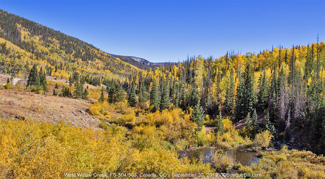 |
| This is where the Bachelor Loop "loops." |
The best vistas were toward the end of the return loop as views across the Rio Grande valley came into sight. The photos aren't great as the camera had to look into the afternoon sun.
As I was coming down the mountain I did notice a road with a number of trailers/RVs disperse camped. If someone wanted a free site very close to Creede this might be a viable option. They were camped along FS-504.1C as Google Maps names it.
 |
Looking south at the mountains across the Rio Grande.
If you view the larger image you can just make out the campers along the road in the middle distance. |
Links for more information on
historic Creede and the
Bachelor Loop.
As I was leaving Creede I stopped at The Clay Mine. It was still a little windy, but not quite as strong as it had been in the narrow canyon, plus this was a much more open area. So I took to the air for photos and video.
 |
| The Clay Mine - No, not named after anyone named Clay, they mined clay here. |
North Clear Creek
As I continued up The Silver Thread Highway the percentage of aspen showing bright autumn colors increased. I turned off onto FS-510 which is a gravel road that passes a couple USFS campgrounds and comes out near the North Clear Creek Falls observation point. I knew from past trips there were a number of dispersed campsites all along this road. This time of year the official campgrounds were already closed, but I nearly always prefer a dispersed site. I drove the road, and a short ways along FS-509, looking for a good campsite and taking photos of the aspen and of Bristol Head mountain.
 |
| Bristol Head |
I met a nice lady from Arkansas who was photographing the aspen reflected in a beaver pond. She said she'd been up here many years ago and the pond was much larger. I helped her with her camera which she had accidentally set to delayed shutter and couldn't figure how to turn that feature off.
At my favorite observation point for Bristol Head I met a photographer from Oklahoma. He had his tripod setup ready for when the evening light shown on rock face across the valley. We had a good chat. I didn't wait around for that golden light as I still needed to find a campsite.
 |
| Bristol Head from the overlook just east of the falls access road. |
I drove a short ways back down the hill to a side road that I had hoped would lead to a nice campsite. Sure enough I found a pleasant site to camp. It was in the middle of an aspen grove.
 |
| Campsite in among the golden aspen. |
The wind had finally died down a bit, so I launched from my site straight up into the sky to take a few photos in the "golden hour."
 |
| Looking northeast from above my campsite toward the location of the falls |
Tuesday, Oct 1
North Clear Creek (continued)
Another chilly morning, but the sun was up shining through the aspen leaves of my campsite. I launched the drone up through the canopy as I had the evening before. The light was obviously from a different direction. It lit up the aspen all around. It was glorious.
 |
| The aspen around my campsite |
 |
| Can you see my camper? |
 |
| 6 exposure panorama |
North Clear Creek Falls
I had hoped I could catch the sun shining on North Clear Creek Falls. I got there about 10 and the light was great. I got some good video and photos, but I could have framed the scene better. The wind had kicked up again and I was reluctant to fly too far or stay up too long.
 |
| North Clear Creek Falls |
Weminuche Overlook
From the falls overlook I drove the short distance to the highway and turned back toward Creede. There is a scenic turnout just down the highway that overlooks Brown Lakes with the Weminuche Wilderness far in the background. I thought I recalled lots of aspen in that area and my memory was correct.
 |
| View from highway overlook |
 |
| Same view, but from above. |
Here is a spherical panorama taken from above the overlook. You can see the beautiful autumn colors in every direction:
I headed back north on CO-149 across Spring Creek Pass and up toward Slumgullion Pass. For several years they have been harvesting the thousands of trees along the road that had been killed by the Spruce Beetle. That work is almost completely done and that stretch looks so much better. There are many little evergreens growing now, and aspen, of course.
 |
Westerly view from Slumgullion Pass.
The mountains in the background are those around Silverton and Ouray - the direction I'm headed. |
The USFS campground at Slumgullion Pass is not yet reopened, but it is no longer cordoned off, so you could camp there if you choose.
 |
| A vast aspen grove as seen from the Windy Point scenic overlook. |
I pulled over at the Lake San Cristobal overlook located at a curve just before the highway drops down into the river valley. I walked up the path to where there was a great view of the lake and the aspen on the surrounding hills.
 |
| View of San Cristobal Lake from the highway overlook. |
Lake City
Just to be on the safe side, I topped off my gas tank in town. The
station also has a kitchen I and enjoyed a BBQ chicken sandwich to top off my belly.
Lake San Cristobal
I took more photos around the lake, but the light wasn't brilliant. Here's the only one worth your time.
 |
| View down the length of Lake San Cristobal |
I continued up the road toward the pass.
 |
| The road will thread its way up the canyon. |
 |
| Cinnamon Pass Road where it is still passenger car friendly. |
Sherman
I took County Road 35 south toward the historic townsite of Sherman. I saw the sign; didn't see the town. The first mile or so of the road is through private land with summer cabins. Once you enter national forest there is a very small, free, primitive campground (with vault toilet), half on one side of the road, half on the other. From Google Maps it looked like the road would go quite a ways with a number of prospective dispersed sites along the valley. However, not far past the campground the road narrowed and headed up steeply. It looked quite rocky and since I was headed for the pass, I didn't go any farther. I stopped at the toilet before continuing and a couple ATVs came past from up the road. I asked the lead driver about the condition of the road and he said it wasn't bad, that my truck could do it. Of course his definition of "bad" and mine might differ.
There was a couple in a SUV that came in from the "main" road. I said hi and asked if they'd found the ghost town as I hadn't. They said yes, but it wasn't much, just two small buildings that were mostly
fallen to nothing. Here's a photo of one.
 |
| Sherman Townsite |
This trip continues in Part 2