This post continues and concludes my trip. See the first part, here.
Remember to click any photo to view larger versions - highly recommended.
Part Two: Beyond the Rio Grande and Back
Thursday, October 1st (continued)
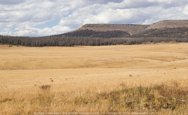
North Clear Creek Area
 |
| Aspen along the forest road. |
Back at CO-149 I turned left to drive northwest to check out an area I spied last year and wanted to explore, North Clear Creek. I turned off onto FS-510, which is marked for Bristol Head Campground. Bristol Head is a tall mountain with a spectacular cliff face, perhaps you saw the
photo of it from my post last autumn. I drove down 510 to explore. (Note: on both the current MVUM and my old Rio Grande NF maps, it looks like 510 does not go through from one end to the other, being blocked by private land. That is simply not the case - the road goes though, you just are restricted to staying on the road while on private land.)
When I came to the junction with FS-509 I kept to the left as the sign seemed to indicate there was only private land to the right. As the road climbed the view opened up. Near the top was a pull-out above a rock-bound canyon which afforded an amazing view down the valley to Bristol Head. I stopped there and had lunch admiring the view.
 |
| Looking down the valley at Bristol Head from my lunch spot. |
 |
I've just updated my blog's header image to this one.
I include it here in case you come across this post after I've changed to header to another photo. |
After lunch I continued up the road and almost immediately came to North Clear Creek Falls. Sorry, New Mexico, but this is a real waterfall. The falls parking area is actually less than a mile from CO-149 via an asphalt road, so if you are just passing though on the highway look for the turn off, and then remember there's a great view of Bristol Head only about a quarter of a mile farther along on the gravel road.
 |
| Note how thin the layer of top soil is above the rock base. |
Instead of heading straight to the highway I turned around and went back down 510. From my lunch spot I'd seen a road to explore - the branch I hadn't taken before, FS-509. You can only go about 3 miles along this road before it dead-ends at private land, but there were nice views and a number of places that looked like access for dispersed camping. I also saw a moose cross the road.
 |
| Bristol Head just peeking above the ridgeline. |
 |
A poor quality photo of a moose taken through my truck windshield,
but since it is only my second moose photo ever, I've included it here. |
I turned around and then turned left onto 510 to head back to where I entered from the highway. Before I got back on the pavement I explored a short ways down a two track signed as FS-556. It was rough in places and didn't get anywhere before there was a mud pit I decided not to try and cross. It wasn't scenic enough for photos either.
Back on CO-149 I turned north toward Lake City. I'd seen a road on the map marked FS-532 and wanted to explore along it, hoping for nice views. It leads along the top of a broad ridge and eventually climbs the backside of Bristol Head, though I was told the last miles were extremely rough. This road turned out not to be very interesting. It climbs, but without affording much of a view. There were very few opportunities for camping. Once on top, you are in a grassland area, which I suppose could be of interest other times of year, but there were no aspen at this elevation. I turned around and returned to the highway.
 |
| The grass will grow green next year, but those fir trees were killed by beetles. |
Passing across Spring Creek and Slumgullion Passes
The forest service is removing many of the dead trees along both sides of the highway in the Slumgullion Pass area. These beetle killed trees were an eyesore and curiously the most severe infestation seems to have been 100 yards either side of the highway. The tree removal is rather ugly now, but a few years growth will make a world of difference.
I stopped, as per usual, at the Windy Point Overlook. The clouds had been building, so the views were not as great as on previous trips, but lots of aspen were showing. At the bottom of the mountain I took the road that leads past Lake San Cristobal and toward Cinnamon Pass. Last year I got nice aspen photos along the lake, this year there didn't seem to be as much color and waves on the lake prevented any reflections of the trees.
Cinnamon Pass Road
I had considered crossing Cinnamon Pass, but in the end decided not to this trip. I did drive up the road as far as the Silver Creek and Grizzly Gulch trail heads, but then turned around. The road was rocky and bumpy, but easily passible - and not as bad as I recall the road up to Animas Forks was, on the other side.
All this area is BLM land. Next time I want to explore the spur road that passes through the Sherman townsite. It follows Cottonwood Creek for several miles and might be interesting.
 |
It is a shelf road along this stretch, but there was one scenic spot to pull over and take this photo.
I believe that's the Lake Fork of the Gunnison River seen in the bottom left corner of the photo. |
 |
| An old cabin near the trail heads. |
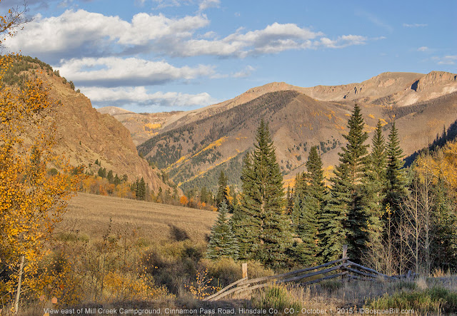 |
| View east from Mill Creek BLM Campground |
I decided to stay at the BLM Mill Creek Campground which was nice enough, but not as pretty as the previous night's site. The NFS Williams Creek Campground was closed for the season and there is a lot of private land along the road.
 |
| My campsite |
I did meet a fellow who gave me a tip on a nice dispersed camping area close by. He was pulling a trailer this trip, so was staying in the campground.
Friday, October 2nd
The morning brought the sound of wind blown aspen leaves clattering against the camper. The low was only 44º. I drove back down toward Lake City after taking a short walk and a few photos. Once back on the road I did find the dispersed camping area the fellow in the campground told me about - it is quite close to the Mill Creek CG and not easily seen driving by. I'm not going to publicize it here, but email me if you want directions.
 |
| Another view from the campground. |
 |
| Same mountain as the photo above, but this time with running water. |
In Lake City I put gas in the truck and headed up Engineer Pass Road. I didn't intend to go over the pass - I felt the weather closing in - but to survey the territory.
Engineer Pass Road
Leaving town the road closely follows the creek through a canyon with towering, solid-rock cliffs. It is a patchwork of private and BLM lands. On the public lands are a few dispersed campsites, most no more than a pull-off from the road.
 |
| The road just outside Lake City passes through a narrow canyon |
 |
| The road follows Henson Creek |
 |
| Another photo showing the steep canyon walls. |
 |
| Finally the land opens into this valley. |
I stopped at what used to be Capitol City and now is two abandoned, wooden buildings. I turned around here as there didn't seem to be many aspen up ahead. I stopped at one of the pull-outs to have lunch.
 |
| Here lies Capitol City |
 |
| Spectacular views from the Capitol City site. |
 |
| Yes, beautiful views and rapidly darkening clouds. |
 |
| Headed back toward Lake City. I think that is Lake Mountain in the distance. |
 |
| One last photo of the canyon walls. Thanks for your indulgence. |
The wind was really whipping as I was driving back to Lake City. Dark clouds were building to the west. That convinced me not to go north and around to Owl Creek Pass and points west. Instead I'd head back east and south to the areas I'd visited earlier in this trip. Perhaps I could get better photos with better light. There were also a couple of roads leading into valleys south of the rio which might hold colorful aspen.
In Full Retreat
As I crossed Slumgullion Pass, then Clear Creek Pass, I realized this modified plan, too, was forlorn, as the clouds were rapidly moving eastward and bringing light rain. So I kept going. Perhaps I would check out Wolf Creek Pass and the areas south of there, then east across the Conejos District. But as I got to South Fork I could see the rain pouring over Wolf Creek Pass. Consequently, I continued east to Alamosa, then south. Maybe Conejos area was clear from the east. If not, then perhaps northern NM was drier and with autumn colors.
Those hopes were dashed, too, as rain could be seen nearly everywhere. I thought about heading into the canyon of Rio de los Piños, one of my favorite northern NM spots, but the idea of sitting in my camper with the wind howling down the canyon and slamming into my rig, persuaded me to keep driving.
US-285 passes San Antonio Mountain, a free-standing volcanic peak in Rio Arriba County, New Mexico. With an elevation of 10,908 feet, San Antonio Mountain is the highest peak within the Taos Plateau volcanic field, the largest volcanic field within the Rio Grande Rift valley.
 |
| San Antonio Mountain, covered in aspen, shows its colors in a brief patch of sunshine. |
My consolation prize was a plate of NM style flat enchiladas at Angelina's in Española - yummy! It was pouring rain over Santa Fe, but the relief route around to the west was dry. As I turned south on the freeway there were only a few patches of light rain and and an amazing sunset. I mentally crossed my fingers that the idiots driving way too fast for conditions wouldn't crash and block traffic. Luck was in my favor in that, at least, and I made it home safe in the last light of the day.
Thanks for reading along. I hope you enjoyed the photos.


