Showing posts with label Canyon de Chelly. Show all posts

Sunday, May 29, 2016

Spring 2016 Shakedown, AZ and NM: Part 3

Part 3 of 3

Hubbell Trading Post, Canyon de Chelly, Window Rock, Zuni Mountains

Continued from Part 2 - Began in Part 1

May 4, 2016 (continued)

Remember to click any photo for a larger version - highly recommended.
In many cases I have posted only a few site photos in the blog. Look for links to full photo albums.

Hubbell Trading Post National Historic Site


From Petrified Forest, I drove east on I-40 for a little over 20 miles where I exited onto north US-191 for the drive to Ganado, AZ, location of the Hubbell Trading Post (NPS site.)

This site is the oldest continually operating trading post in the Navajo Nation. Some visitors leave unimpressed, but I find it fascinating. Don't forget, if you visit this area in summer, Arizona does not observe daylight savings time, but the Navajo Nation does.

Main Entrance

General Store; first room inside entrance.

Basket Room

Blanket Room

Another view of the Blanket Room

View my full Hubbell Trading Post photo album.


Canyon de Chelly National Monument


I was returning to Canyon de Chelly primarily to take photos of Spider Rock in better light than I found on my last visit late last year. From Hubbell I continued on 191, stopping only for gas in Chinle, then directly to the Spider Rock overlook. The sky was full with small, medium, and large puffy clouds. That was beautiful to see, but a challenge to photography. I'll show you two photo versions, one with clouds and one where the entire canyon was covered in cloud.

Spider Rock - Cloudy Version with strong Orton effect.

Spider Rock - Contrast Version with mild Orton effect.

After I left Spider Rock I camped in the native-owned Cottonwood Campground with lots of other folks. Although cars and RVs were lined up to enter and it took a while to advance to the entrance station, there were plenty of sites for everyone. The weather was mild, but the campground should be pleasant even in warmer times due to all the cottonwood trees. This early in the season the leafy canopy is not fully developed. There is no dispersed camping anywhere nearby; there is one other private campground near the end of the south rim road.

Cottonwood Campground located off the highway near the park entrance.

I saw my friends from the night before come in and camp. I also struck up an interesting conversation with some folks I'd seen at Spider Rock. They were from Washington state and were visiting sites in Indian country that had been featured in the famous mystery novels of Tony Hillerman. As I am also a fan of those Navajo detective stories, we had lots to talk about.

May 5th

Canyon de Chelly (continued)

Antelope House


I intended to visit the sites along the north rim that I didn’t get to last fall. My first stop was the Antelope House overlook. At the visitor center they recommend the north rim for mornings and the south rim for afternoon, but I discovered you can be too early for good photos on the north rim. I arrived at the first stop at 9am, but had to hang around until 10am before the full ruin was in the sun. Not that hanging around that spectacular scenery on a beautiful morning was much of an imposition.

Beautiful view of Canyon del Muerto from the NE overlook at the Antelope House site.

Antelope House is named for the beautiful pictographs painted on the cliff face above the ruin. (Though it should really be named Pronghorn House, as this native artiodactyl mammal is not an antelope.) The ruin is dated at 1300 A.D. the illustrations are attributed to a Navajo artist in the 1800s.

Antelope House at the foot of a sheer cliff

Antelope House Pictographs. They are just above the ruin and to the left.

While waiting for the canyon shadow to recede, I met an interesting amateur photographer from Hamburg. Achim was driving around the southwest for the entire month of May visiting as many parks and scenic areas as he could, as far north as Grand Tetons and Yellowstone, before returning to Phoenix for the flight home. We had a fun discussion about southwestern scenery and photography, and our conversations have continued via email ever since.

Note the colorful chin on this lizard.

Mummy Cave Ruin and Yucca Cave Ruin


These two ruins are close to one another and the northern most in the park. Mummy Cave Ruin is one of the largest in the canyon and the details can be more easily seen than with others due to the contrast between the light walls and dark rock floor. Yucca Cave Ruin is one of the few located near the rim of the canyon.

Mummy Cave ruin is midway up the cliff at left.

Composite telephoto panorama of the Mummy Cave ruin.

I spotted this Peregrine Falcon fly up to this perch. The falcon never moved where I could get a better photo.

Yucca Cave ruin high above the canyon floor - probably accessed from above.

View my full Canyon de Chelly photo album.

From the last overlook I continued north on the rim road, Indian Route 64, to IR-12 and down to Window Rock.

Window Rock, AZ


While looking for the "Navajo Inn" to have lunch in a Hillerman novel, I found the actual Window Rock. I photographed it and the Code Talker statue. There was a Quality Inn with its Diné Restaurant. I'm guessing that was the place, but with the name changed in the book. I stopped in for a late lunch and had their Navajo Taco. I thought it was a bit expensive, but I had a pleasant table with a nice view of the courtyard and fountain, so was happy. The restaurant seems to be popular with the locals.
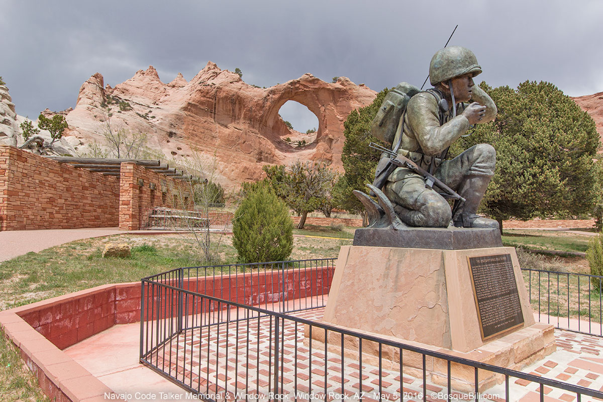
Window Rock and the Navajo Code Talker Memorial

Zuni Mountains, Cibola National Forest, NM


From Window Rock I drove to Gallup, NM and got on eastbound I-40. After just a few miles I turned south on NM-400 at Wingate. My intention was to drive through the Zuni Mountains on FR-50. This small mountain range is located south of I-40 roughly between Gallup and Grants. I had never been in this exact piece of New Mexico and was curious what was here.

You lookin' at me?

The two forest service campgrounds in the McGaffey vicinity were both closed, not that I had intended to stop, just a FYI. The asphalt road turned to gravel. The road was very good for a number of miles passing through meadows and grasslands, and I saw a herd of elk cross the road ahead. I was following FR-50 which looks like a good, through road on the map. At a junction by a large ranch there was a sign: “Primitive Road - Not Suitable for Passenger Vehicles.”

That didn't concern me too much at first, but over the next several miles, slowly following the route, I decided the road was barely suitable for high-clearance 4-wheel drive vehicles. Yikes! It would have been impassable just a few days before due to rain in the area. The mostly hardened ruts were extremely deep and there were many tricky places where I held my breath. For all the effort, the scenery was that of your basic Ponderosa forest - nothing extraordinary, nothing to call for a repeat visit.

A view of Mt. Taylor as I came down out of Zuni Mountains.

I finally came to FR-480 which was in much better shape. I followed it to FR-178, though remnants of wildfire, to FR-180 (a.k.a., Zuni Canyon Road), to Grants. If you ever pick up a brochure for the Zuni Mountain Historic Auto Tour (for railroad buffs) ask a knowledgable local about road conditions before you start out. The last sites, north on 50, would not have been accessible to a passenger vehicle and I saw no sign at that end of the road warning of the primitive conditions.

Pretty roadside wildflower.

On the way home.


I rejoined I-40 and drove home, arriving at dusk. That last section in the Zuni Mountains notwithstanding, this was an extremely enjoyable trip with lots of great scenery and camping. It was one of those rare trips where all the pieces fell into place.

Thanks for reading along.

Tuesday, January 12, 2016

Four Corners: November 2015 - Part 2

A Loop along the Ancient Way though the Navajo Nation
November 8 - 13, 2015

This tale begins in Part 1, where you can also find a road map of my journey.

Part 2 of 2 - Navajo Redlands

Wednesday, November 11th (continued)


After leaving the Hovenweep area the storm began in earnest with torrential rain and gusty winds. The westerly route toward Bluff was narrow and not easy to follow as it was poorly marked, but I did find my way (though I had to backtrack at one unmarked intersection). At US-191 I turned south toward Bluff. This small town seems to have shrunk even more since the last time I was through there, perhaps more places were closed simply due to it being November and not the thick of tourist season. From the highway I could see the storm structure centered over the Monument Valley area appearing as a wall cloud indicating severe weather, though the rain had let up where I was. West of Bluff I drove straight at the junction where 191 heads south; I was now on US-163 which leads to Mexican Hat though I didn't go that far this day.

I thought I'd check out Goosenecks State Park as I'd driven by the turnoff a number of times. You take UT-261, then turn south a few miles along. I didn't know if I wanted to camp there or not. Though there is no attendant this time of year, the state certainly emphasizes the need to pay a fee to enter and/or camp. The camping area is basically a flat area with an occasional picnic table; there is one vault toilet in the day use area. The wind was fierce at this edge of the canyon of the San Juan River, resulting in a wind chill of "too damn cold." I hurriedly took a few photos, retreated to my truck, and exited the park.

Remember to click on any photo to see larger versions in a lightbox type presentation.

View of the San Juan River from the canyon rim at Goosenecks State Park

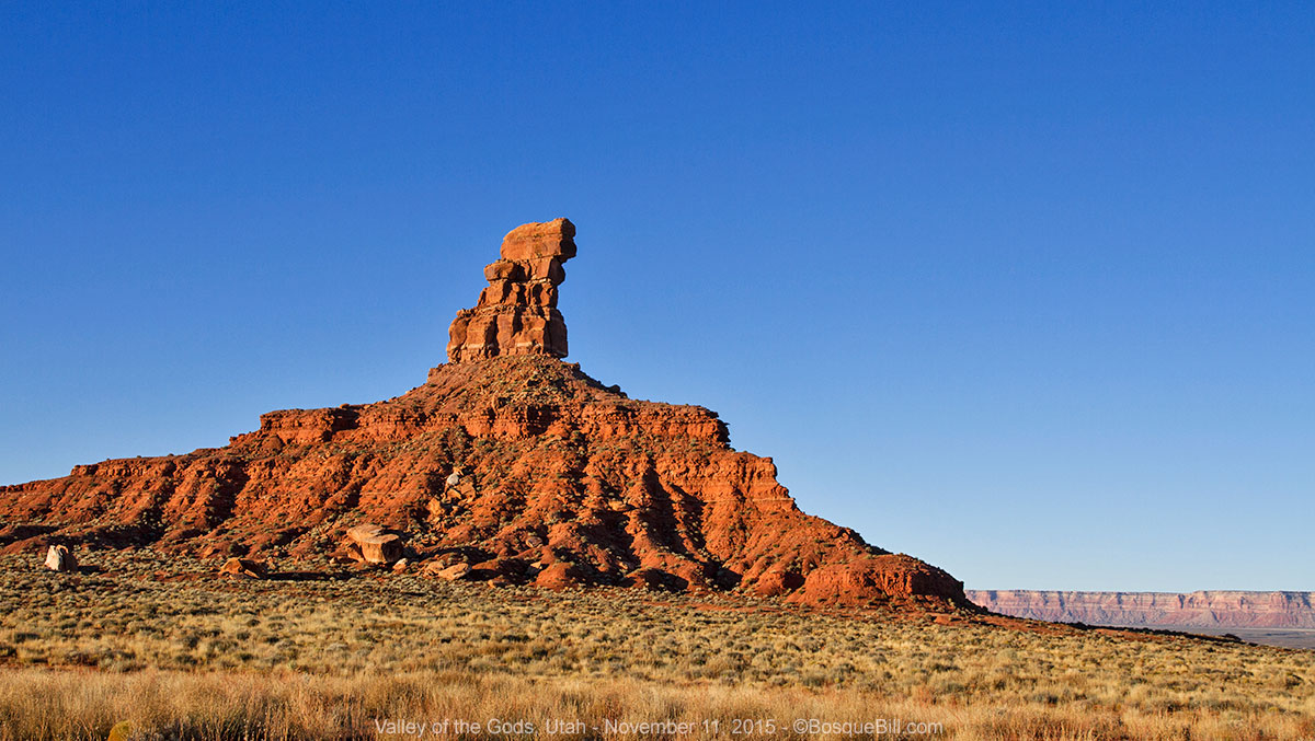
Valley of the Gods


I returned to the Valley of the Gods area and entered via the east entrance from US-163. I viewed with some trepidation the warning sign that the road was impassible when wet, especially as there is a creek crossing as soon as you drive in, and the clouds were still threatening more rain. Nonetheless, the road was in excellent condition even after the afternoon rains. I drove in looking for spots to camp, taking note of likely sites. Most sites are in the open which afford wonderful views of the landscape, but there were one or two more sheltered that might be appropriate this stormy evening. Despite the heavy clouds, there was much rugged beauty in the area and I took photos in the low light, hoping, but not expecting, them to turn out.

Stormy evening vista of Valley of the Gods

The wind began picking up, I could see more rain approaching, and I knew it would soon be getting dark. I turned around and drove like the dickens back the way I'd come with the intention of finding the campsite I'd spied earlier that seemed to be sheltered from the wind on a couple of sides by small hills. Luckily the site was flat enough I didn't have to level the camper and got set up in record time, barely beating the rain and dark.

I turned around here and scurried back to what shelter I could find.

It's hard to judge rain intensity in the camper with its large aluminum roof area, so was relieved when it let up, though had no idea what condition the road would be the next morning. Not that I had a pressing schedule to keep.

Wednesday, November 11th


As I awoke with dawn approaching, I peeked out the window and the sky appeared cloudy, so I didn't rush my morning routine. As I was making coffee and breakfast I heard a vehicle. Looking out I saw a small sedan driving by from the direction of the east entrance, so the road was ok that direction apparently. I was surprised though to see there were only a few clouds along the eastern horizon, but most of the sky was in fact clear.

Just before sunrise looking east from my campsite.

This stirred me to grab my camera and tripod to get some dawn photos from next to the campsite - I wasn't even fully dressed at that point, but the light wasn't waiting for me. It was a glorious dawn. I'd take photos then go back into the camper to dress and finish breakfast, rush out for more photos in the changing light, go back to the camper to start breaking camp, out for more photos, etc.

My campsite, sheltered from the worst of the previous night's winds, is lit by the rising sun.

Gorgeous view just as the sun lights the scenery. Monument Valley is along the horizon.

I got underway and drove deeper into the valley stopping frequently for photos.

Looking across the valley basin in a southeasterly direction. Muley Point is on those cliffs.

This bluff and tower stands alone.

Another view across the basin with Monument Valley in the background.

Following the road deep into the formation of Valley of the Gods.

Towers along the way.

The square rock block along the road is about the size of a large truck.

Lots of amazing views all along the road.

Looking back as I drive out of the area of the most formations.

After driving through the valley, I exited onto UT-261, turned south back to US-163, headed toward Monument Valley. FYI, if you are wandering in this area, it seems that Mexican Hat is probably the best place to get gasoline. The Shell station is nicer than anything in Bluff and the prices were lower than there or in Kayenta, at least this trip.

View just off the highway of the north side of Monument Valley

Monument Valley


Note: though I have included a number of photos in this post, there are more in my Google Photos Collection, many I think are quite nice and I bet you will enjoy seeing.

There have been some changes to this Navajo Nation park since my last visit 10+ years ago. The visitor center is a new complex right next to the US highway, you join the jeep tours there (if not at Blandings.) Also, back in the day you could drive to the hotel complex and get fabulous photos of The Mittens from their overlook for free. Nowadays, you pay your $20 (1 to 4 persons/car) long before you get to the hotel complex. Your entry receipt is good for four days, I was told.

I did indeed stop at the hotel complex. Their overlook is one of the best views of the valley.

View from the deck outside the gift shop.

They are putting this new income to good use. The main (dirt) road into the valley has been widened and is kept graded; plus, they are installing culverts at the major wash-out places. Smart, as this will keep the park accessible even after a gully-washer rain. Another change is the great increase in the number of "jeep" tours on the road. I put the vehicle in quotes as there are no Jeeps (and I saw no "people movers" either); they all seem to be variations on heavy duty pickups with the bed converted to hold about a dozen visitors in the open air - and man, were those tourists ever shivering this November morning as I drove in.

I drove around the loop road, stopping often for photos. Some of the features were in good light, some would be better later in the day, and others would have been better earlier in the morning. So I hoped to stay somewhere in the area to get photos the next morning. The main tribal park campground was closed for the season, but their "primitive" site was open. It is a small area with picnic tables and ramadas, located about halfway between the US highway and the hotel complex, not the most scenic spot. The lady at the entrance station said it cost $20 per night.

When I pulled into the overlook called Artists Point, I noticed an old VW bus camper (along with the spectacular view.) This brought back fond memories of my '68 VW Campmobile (tm) and I strolled over to share this with the owner of the bus. Jerry, a TV producer from L.A., had only recently acquired said VW after a long search for one. This friendly fellow was interested in my tale and we spent an enjoyable time swapping stories.

Afternoon view from Artists Point.

One of the things he mentioned was being in Monument Valley during the worst of the previous day's storm, and it soon became apparent that he had camped within the valley that night, which caught my attention. When asked about this, he told me who to talk to at one of the horse tour corrals, which I did.

The primitive campsite is down one to the roads closed to all except guided jeep tours, so my host drove in with me following behind though a complex of "roads." Wow! The spot was literally at the foot of Thunderbird Mesa with a view of the Sleeping Dragon. I set up the camper at the base of the enormous sandstone formation and walked out to try and capture the scene with my camera.

Campsite at the foot of Thunderbird Mesa

My host, who'd stuck around to make sure I got settled, saw me taking pictures and asked if I'd like to see the Totem Pole? He cleared off the front seat of his aging Chevy 4x4 pickup truck and off we went. The truck only had 1st and 3rd gears, bald tires, and you had to throw yourself at the door to get it to open (but at least it wouldn't accidentally fly open as we went blasting along these "roads.")

The Totem Pole

My personal tour guide was having fun showing me the sights and I did not have to pretend to be amazed by the beauty of the scenery. The day was well into the "golden hour", or even a bit late, so photography was a challenge, especially as I'd not brought my tripod.

The finale was a view of the icons of the valley as seen through the "periscope" on top of Submarine Hill.

Looking through the periscope.

I was returned safely to the campsite as it was starting to get dark, and my host took off to return to the corral and watch over the horses as they have a talent for getting themselves into trouble, he said.

As I fell asleep that night I tried not to think of the huge sandstone cliff looming over me.

Thursday, November 12th


Monument Valley (continued)


I got a reasonably early start in the morning. The light was very nice and I got lots of photos of features that were in shadows the previous afternoon.

View from Ford's Point, looking northerly.

When I felt like I'd done it all, I headed out of the park and toward Kayenta on the US highway, where I picked up provisions at Basha's market and filled the gas tank. My intention was to visit Canyon de Chelly as I worked my way toward home. I drove east on US-160 for a few miles before turning south on Indian Route 59. Going this way cuts a number of miles off the route. It's a two-lane highway in very good condition with interesting scenery.

Agatha Peak, a volcanic diatreme between Monument Valley and Kayenta.

Canyon de Chelly


Note: There are several more of my photos collected on this Google photo page that I hope you will find interesting and/or scenic.

View from the Tsegi Overlook

I arrived at the national monument shortly after lunch, picking up a map at the visitor center. I checked out the private campground just inside the park. It looked very nice with lots of trees and grass, though only one loop was open this time of year. I didn't know if I'd stay the night or not at this point, but didn't have to decide then as my plan was to drive the south rim, which is an out-and-back route.

White House ruin, in situ. For a closer look, visit the photo collection.

I stopped at all the overlooks on my drive east along the rim and took lots of photos. I paused at one and ate the turkey sandwich I'd bought earlier at Basha's. This late in the season the shadows were long and the days are short, so I didn't take the trail down near the White House ruins. One doesn't need a guide for this trail, whereas you need a guide, or to take a tour, to explore the canyon bottom at all other locations. Next time.

I realized I'd made a mistake once I got to the effective end of the road to view Spider Rock, as the shadows had already started climbing the rock. I would have gotten much better photos if I'd driven to the end of the road first for those photos, then worked my way back. Oh, well. I told myself that I'd just have to come back sooner rather than later. With that last understanding, I decided not to camp at the park and drive the north rim in the morning. I'd head for home and save all that for another trip.

Spider Rock (with the shadows cropped out.)

I drove out of the park and south on US-191 all the way to eastbound I-40. I stopped for cheap gas in western Gallup and it was soon dark. I topped up my belly with a green chile cheeseburger at the Lotaburger in Grants. The drive on the dark freeway was thankfully uneventful and I made it home safe.

Thanks for reading along.