Wednesday, September 13, 2023

SE San Juan Mountains, CO & NM: Part 3

Part 3 of 3: Begins with Part 1; Part 2

Remember to click any photo for a larger version.


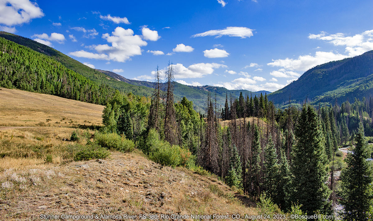
Thursday, August 24 (continued)


New Mexico

Rio de los Piños

The route to my favorite spot in northern New Mexico is not marked or obvious. If you come in via forest roads south of San Antonio Mountain you can easily follow the Carson National Forest map or a good atlas, such as the Benchmark series. From the north, you need to begin in Colorado. Just south of Antonito, CO I turned right off of US-285 onto County Road 12.5. This is immediately past the Cumbres & Toltec Railroad tracks. One follows the pavement until it makes a sharp bend to the left; there you continue straight on gravel.

Several years ago I was talking to someone who was familiar with this area and they asked if I knew about the Mennonite Colony around there. I did not and had not seen any indications previous years. This time as I was driving in I came across a horse drawn carriage with six young people in appropriate dress coming the other way. I slowed down and waved as they passed. The kids turned around to stare at the strange apparition they'd just seen. Lest I forget to tell you, on my way out, just across the state line in San Antonio I drove past a bearded Elder on his bicycle returning to the colony (I assume) and he gave me a wave.

It's a pleasant drive along the Rio de los Piños next to the bosque. There is a state wildlife refuge along the way which is a popular trout fishing area. They also have vault toilets at a few access points, which was appreciated as the gas station in Antonito had no facilities.

Road coming into the campground

I was hoping I would find a good camping site. I was coming in fairly early on a Thursday afternoon, so thought my prospects were good. The little meadow along the river where I'd camped a couple times before was available. It was a bit on the hot side this day, but could be a Plan B, if needed. But in fact the first official site was open and looked great, so I pulled in there. 

Campsite along the river

It had been a couple of years since I'd been back here and it looked like the forest service had cleared away quite a bit of the underbrush and low hanging trees that had made the campground just a little claustrophobic before. They'd also brought in gravel to fill the many mud puddles that plagued the road in the past. On my walk the next day I confirmed they'd similarly cleared the other sites and added gravel to the road. 

I was able to set up the camper so the solar panels got sun and I set up my comfy chair in the shade to watch the river. There was a momma Western Wood-Peewee teaching her two young how to catch flies over the river. At some point I should mention this is a New Mexico mountain river, what those from wetter climes would call a stream or a brook. But you'll figure that out from the photos, I guess.

Juvenile Western Wood-Peewees

I'd never seen Water Striders rafting before

The view from my camp chair

I didn't notice right away that my concrete picnic table had a mural. Pretty cool. I photoshopped off some graffiti, but didn't try to fix the damage due to moisture wicking up from the ground and peeling off the paint.

I had the coolest table in all the campground

It was a quiet evening after a quiet afternoon. Just before dusk a motorcyclist rode past. Looked like he was set up for back country touring/camping.


Friday, August 25

Rio de los Piños (continued)


Yellow flowers along the river

It was a beautiful morning and I enjoyed my coffee in my chair beside the river. About 9am I decided to walk up the road with my cameras. I took a few "landscape" photos, but as I've posted many, many before I concentrated on photographing the critters—not that they cooperated. I've had to really (over) process some of these so you can see what the backlit birds even look like. 

Hairy Woodpecker

Maybe the best bird photo of the trip—a House Wren


I kept hearing jay-like calls from many birds that flew high from one side of the canyon to the other, but evaded my eyeballs. Some were up beyond this rock formation.

Lots of bird activity up on the side of the canyon

Spotted Sandpiper vacationing in New Mexico

I counted the camping spots and picnic tables as I walked. There were 6 tables at nice campsites. There were a few other sites where one could camp without a table. There was another vault toilet near the 6th official site. I guess that was the end of the campground per sé.

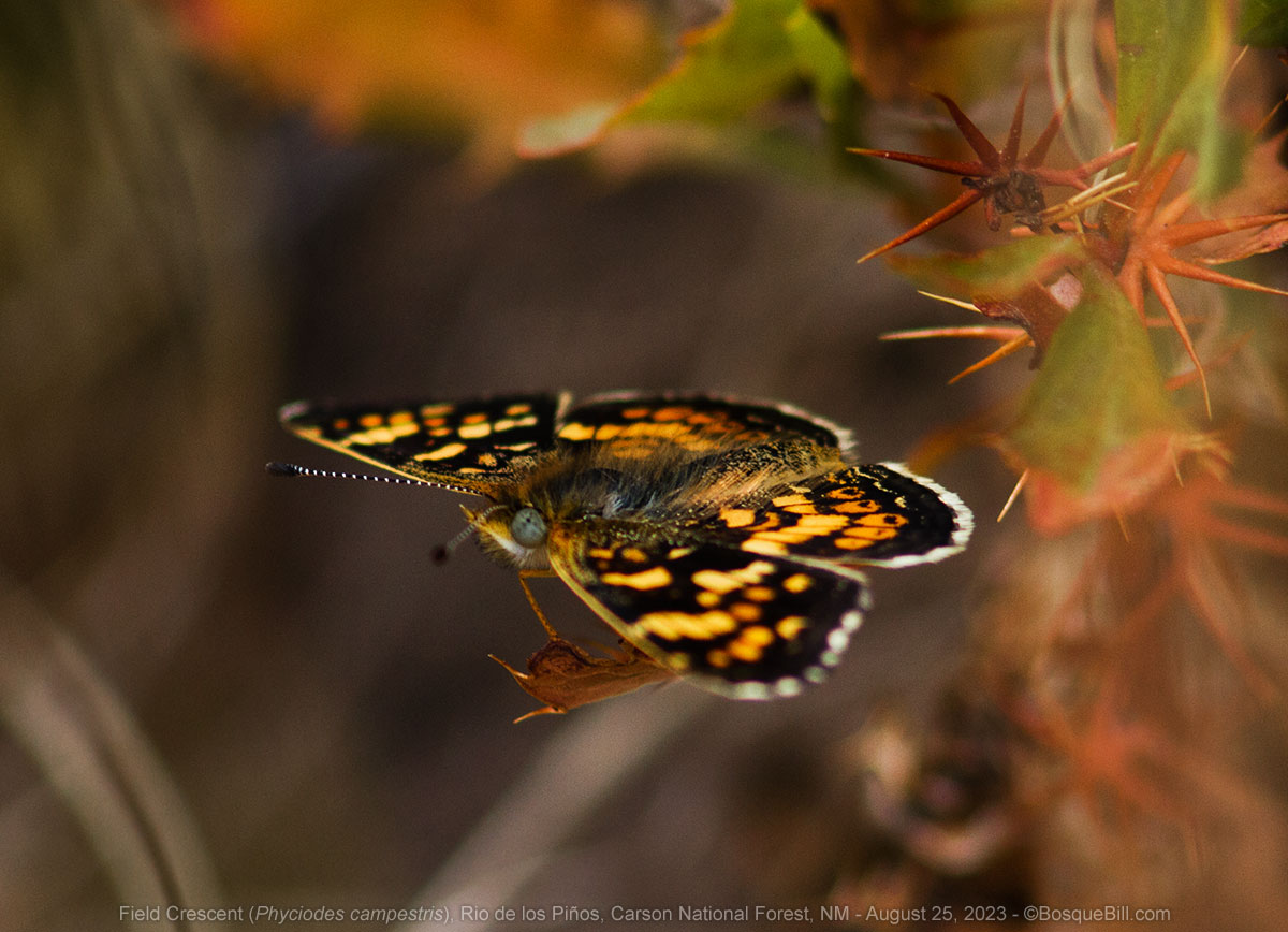
A Field Crescent previewing the autumn colors soon to come

The motorcyclist was the only person I saw camping this morning, though I didn't walk as far as Cañon Atencio, so may have missed surveying a couple of sites. I spoke briefly with the man who was doing a little maintenance on his motorcycle. He was following a dirt roads backcountry route up from the southern border of New Mexico up into Colorado. I didn't bother him with a photo request.

Such a beautiful little canyon

Plenty of relaxing in the shade by the river that afternoon. I did manage to see and get a photo of one of those raucous birds. Turns out they were Clark's Nutcrackers. A fairly uncommon species (at least anywhere else) that I'd only seen once before. Cool.

Clark's Nutcracker finally revealed

There was some traffic driving through the campground in the afternoon and evening. Actually more than I would have expected especially as you would have to know this out of the way campground was even here. Glad I got a campsite on a Thursday. I enjoyed a pleasant evening.

About 7pm I started hearing thunder. Once I felt a few drops, I began stowing my chair, side table, etc. It was getting dark in any case. I got inside and the heavens opened up. It's easy to over estimate rainfall when in a camper with an aluminum roof, but it did pour and for quite a while, too. It was good as all the green growing things could use a good drink.


Saturday, August 26

Rio de los Piños (continued)


Morning coffee

I again enjoyed my coffee by the river. I walked around hoping for better luck with my bird photography, but it was not to be. I'd decided I'd head back to civilization today, as and the forecast I'd requested the day before using my inReach satellite communicator was for rain all day. Nonetheless, I took my time breaking camp.


On the road

I left via the northern route as it's 45 minutes to the highway rather than a couple of hours, which is a wonderful drive in good weather, but would not be that fun if in the rain. I stopped to photograph some roadside sunflowers. I think the flowers are in New Mexico and the ridge is part of Colorado. If leaving via the north route, but going south, you can take the first right after crossing the ridge. This is Road C and goes straight to the highway.

Roadside sunflowers and a portent on the horizon

I also pulled over at the state line for photos. I'd had to cross back into Colorado to get to US-285. There was a nice view of San Antonio Mountain. You can also see the clouds rapidly building over the mountains I'd just left.

San Antonio Mountain seen from the state line

A view back toward where I'd been camped and the clouds rapidly building

No drama on the drive home. A short delay for some highway resurfacing, but otherwise a smooth trip back down through Española, Santa Fe, then the freeway to the North Valley and home where it was almost muggy due recent rain.


Thanks for reading and following along.


SE San Juan Mountains, CO & NM: Part 2

Part 2 of 3; Story begins in Part 1

Remember to click on any photo for a larger version.


Wednesday, August 23

East Fork Dispersed Camping Area (continued)

When I got up in the morning I could smell wood smoke. Apparently the wind shifted and the wildfire smoke was drifting this way. I'd thought I'd spend two days in this area, but the situation had changed. I had breakfast, broke camp, and headed back to the highway.


Rio Grande National Forest

I turned north on US-160 and drove up and over Wolf Creek Pass. In looking at the map I'd seen a road I'd not explored that took off east of the highway to Big Meadows Reservoir. There was a USFS campground there, but the road continued on and perhaps there was dispersed camping up there that way.

Big Meadows

I turned off the highway and shortly saw a large sign that stated camping was only allowed in designated campgrounds. That seemed to put the kibosh on dispersed camping. I went ahead to check out the reservoir and campground. Looks like a good place for folks who want to fish for lake trout. I didn't check the regulations, but I suspect they allow small trolling boats, not that I saw any. 

Big Meadows Reservoir

The campground was situated up the slope beside the lake. There were sites with views, but they were generally close together and well populated. I took a couple photos and headed back to the highway. I was asked later if there might have been dispersed camping farther along the road. At the time I thought the sign was all inclusive, but don't really know. If you're interested the District Ranger could tell you.


Eastern San Juans

A few years ago I'd driven up the Conejos River Valley from CO-17. I'd camped in the official dispersed camping area, then continued on to Platoro, then up and over and down Park Creek Road, FS-380. I seemed to recall there were campsites along there. I thought I'd go up that road and around the summits, but skip the Conejos River road as it was miles of miserable washboard. Instead I'd go out by following the Alamosa River which would be new to me.

With this in mind I found and followed Park Creek Road. Sure enough there were camping spots along the river, most of which were occupied. I did find one that was available, but there was a lot of ATV traffic kicking up dust along the road. I kept going and from looking at the satellite maps before my trip knew there were meadows along the river farther up that might provide camping.

Black-tipped Ragwort and Fireweed

One of those meadows was hosting what looked like a jamboree. I passed another that looked promising and backtracked to check it out. There was one large trailer but the double-track appeared to follow the river and I saw no campers there. When I started up the track I found the reason why. The area was blocked off for landscape rehabilitation purposes. Oh, well, onward and upward.

Black-tipped Ragwort, AKA Roadside Senecio, and some stinkweed, too

I checked out a few side roads, but most were pretty gnarly. Another looked sort of OK, but on closer examination the potential campsite was covered in cow patties. Yuck. Another had neither a view or creek access. Since it was still early due to my quick exit from the fire zone, I kept going. When I reached the top there was an interesting spot with a fabulous view, however a chilly wind was kicking up and the site was exposed. I kept going with a Plan B in mind. 

View from the top

A better photo of a Cop Car Moth

Big Red Mountain

On my earlier trip I'd stopped in a small primitive campground near the Stunner mine site to have lunch. That would be my fallback option.


Stunner Campground

It's good to have a Plan B. As I pulled into the campground I was the only one there. It has a half dozen nice sites with picnic tables and a metal fire rings. There is one vault toilet. It was only around 2pm, but I found a pretty site that was level for the camper and could catch some sun if the clouds would cooperate. I took the site rather than drive until I'd exhausted my options and myself.

My campsite with a view of the meadow and valley

Alamosa River as seen from my campsite

Stunner is named for the mining camp near here established in 1892. According to signage 400 miners, gamblers, and camp followers came to this spot, but many quickly moved on. There is supposed to be remnants of the camp around, but I didn't see any.

I was fascinated by the intense blue of this little Gentian

An "artistic" shot of a little paintbrush

I had a pleasant afternoon. One jeep came in with two older couples who had a picnic for an hour across the way. A forest ranger came by to check on the little wetland there have, which I know as I was out looking for flowers to photograph so was able to speak to them briefly. I'd actually had a lazy day, so after dinner I walked the half mile access road back to the "main" road and took a picture of an old cabin there at the junction. Though not in good shape it is much too new to be part of the old mining camp. It was a nice quiet night.

Old cabin—perhaps a defunct forest guard station


Thursday, August 24

Stunner Campground (continued)

No need to rush out of camp this morning and no reason to stay, either. After breakfast I wandered around and took a couple dozen photo of the birds—none of which were worth saving. Got a good photo of a chipmunk, however, as he charged along the road right at me, until he saw me.

Chipmunk suddenly realized I'm standing here.

A beautiful morning in the Alamosa River valley

Here is a spherical panorama of the area:


I'd drive down the Alamosa River Road, FS-250, and see what was there. The map showed a campground situated along the river near the end of the national forest which I'd check out. But most likely I would proceed back to the highway south of Alamosa and head to my favorite northern New Mexico camping spot on the Rio de los Piños River. That would be a very nice conclusion to my trip.

Alamosa River Road

It was a very pleasant drive on a gravel road in good condition. The river was on my right as I drove through the aspen. I kept my eyes peeled in case there were any turn offs to dispersed campsites along the river, but didn't see any. I found one site on the mountain side by a tiny creek, but it wasn't level.

Just before I got to Jasper. I saw a pond right next to the road. I pulled over to see if there were any dragonflies and sure enough I quickly spotted some flying by. I parked and tried my luck.

Alpine dragonfly pond

I enjoyed about 45 minutes of walking around two sides of the pond trying my hand at capturing whatever critters I could with my camera. The first image here is not very good, but I'm posting it as a reminder to always check my settings before shooting. I had a golden opportunity with a usually fast moving darner hovering still in front of me and my shutter speed was too low. He never cooperated again. I heard at least two Pika calling from the talus on the far side of the pond, but never saw them.

Paddle-tailed Darner at too slow of a shudder speed

Northern Bluet damselfly

A terrible pest, but pretty

Northern Bluets in tandem

A Northern Spreadwing—my first

Enormous dragonfly... or perhaps a juvenile Broad-tailed Hummingbird

Alamosa Campground

Jasper is simply a long strip of private land which extends a mile or so farther downstream where folks have built cabins and summer homes. I saw no businesses. There is a last section of the national forest before more private and state land. The Alamosa Campground sits at the bottom of the forest land and is a very pleasant, free campground on the river. There are a half dozen sites, three on the river itself, and one vault toilet. Two of the river sites seemed to be long-term campers; 4 the other sites were open. I found a spot to rest and have a picnic lunch.

Continuing down FS-250 one quickly leaves the pines and conifers for a drier area of piñon and juniper. The road skirts Terrace Reservoir before being directed into a parallel valley. At that point I changed over to FS-255 which would take me south and east to Capulin over dry and dusty gravel roads though desert like terrain. From there it was a straight shot east to La Jara and US-285.


Conejos County

One of the eBooks I'd brought along turned out to be a short novella rather than a full-length novel, so I wanted more reading material. Once I was back on the grid I tried to use my phone as a hot-spot to access the online library. For some reason this just didn't work. Rats! A couple miles south on the highway is a USFS office I stopped there to see if they had WiFi. They had guest WiFi, but it wasn't working. The young man working there provided directions so I could go back about a mile to the county library to use their WiFi. I did and asked the librarian if a traveler could use their WiFi. She wrote out the password for me. I was able to return the books others where waiting for and check out a hold that was ready for me. Excellent.

I filled up the truck at an unattended, credit card only gas station in Antonito, CO. It also seemed to be the only gas in the village and offered only regular grade. Fortunately it was at a good price. 


Story continues in Part 3


SE San Juan Mountains, CO & NM: Part 1

Part 1 of 3

August 20-26, 2023

It had been an unusually hot and dry summer in the middle Rio Grande Valley that I call  home. I needed a break, perhaps in the cool Colorado mountains. However, I seen myself in previous years that many, many others will have had the same plan. I thought if I visited lesser known locales I might find respite. I'd camped along the East Fork of the San Juan River, east of Pagosa Springs, twice before. It has many dispersed campsites along the scenic river. In search of additional options in the same general area I began a thorough search using online satellite imagery. 

I found two excellent prospects both west and east of Pagosa; Hunter Piedra and Quartz creek. I also thought I'd go back up into an area I'd briefly passed through—the Summit area on the other side of the Continental Divide. OK, I had a rough plan.

Remember to click a photo for a larger version which opens a screen you may arrow through


Sunday, August 20

I finished loading my truck and camper and drove north on I-25 from the Albuquerque area. Took the Santa Fe by-pass and stopped briefly in Española for tacos. The day was quickly heating up. The drove to Pagosa Springs on US-84 where I filled the gas tank. I drove west from Pagosa on US-160 to First Fork Road that parallels the east side of the Piedra River.


Hunter Piedra Campground

Twelve miles up the good, gravel road is a small, primitive campground which I had found in the satellite view and confirmed via the San Juan National Forest map. As I drove in I was passed twice by trucks pulling medium-small camping trailers (and also a big truck pulling a long stock-trailer). I was hoping they were on their way home and there would be sites available for me. I was also expecting the temperature to drop with elevation, but it didn't seem to.

There is deluxe concrete bridge that leads to the First Fork Trailhead. Before the bridge you can turn right, upstream, and the road leads you to a stock-trailer parking area and a loop with a vault toilet. There appeared to be a group camped there with a number of tents and vehicles.

Piedra River

If you turn left before the bridge a track takes you to several dispersed campsite with views of the river. There was only one truck in the area with two men preparing to fly fish in the Piedra River. No one was camped so I had my choice. I went all the way to the downstream end to set up. It was close to 90º, not the cool mountain air I'd been hoping for, so after setting up I found a nice piece of shade for my chair and watched the river flow.

My campsite at Hunter Piedra dispersed campground

Yellow flowers along the river bank

I saw lots of butterflies on some yellow flowers next to the river. While trying to get a photo a young woman walked up the river in shorts and water shoes. I said hello and we spoke for a few minutes. She lives in Pagosa and comes up to this area regularly for day hikes and to enjoy the river, including kayaking when there is enough water. I mentioned the butterflies and she said that actually they were "Cop Car" moths (as they are black & white.) She knew the scientific name, but that didn't stick in my brain. I wasn't able to get an in-focus photo of one of the moths this afternoon, however.

A fuzzy bee is gathering dinner

The truck and stock-trailer was a regular commuter heading out, then about a hour or so later driving back in. I finally figured out that the trailhead up by the bridge was the terminus of guided horseback rides. Folks would ride from the other end of the trail, finish here then the wranglers would load up the horses and clients to drive back down the mountain. That kept up until dusk, but fortunately wasn't too disruptive.

A bit of color in the evening sky

It cooled off some in the evening. There wasn't much of a sunset, but there was a photogenic sliver of moon.

A hand-held photo of the moon using my wildlife lens


Monday, August 21

Hunter Piedra Campground (continued)


My campsite at the downstream end of the camping area

It was a beautiful morning. There were three wild turkeys grazing in the meadow next to my camper, but of course they fled when I tried to get a photo. I enjoyed a relaxing morning watching the chipmunks feeding on the chokecherries and other berries along the river. There were birds feeding, too, but they didn't pose for photos. I got an insight into nature when I noticed the critters didn't just grab a fruit, but would carefully examine each bunch and only pick the ripe ones. This is why the bunches look so picked over—because they are!

The chipmunk would forage in the bushes then return to this boulder to eat

Chokecherries thinned out by the squirrels and birds

Finally a half-way decent photo of a Cop Car Moth (and a couple of bees)

Here is a spherical panorama of the area:


It warmed up quickly, but was about ten degrees cooler than the day before. Still, it was too hot to hike and I quickly abandoned my walk up the road past the bridge and returned to camp. I enjoyed more relaxing in the shade and a good book I'd brought along. I had the campground to myself most of the day. Late in the afternoon an occasional car would park next to the bridge and a family would splash around in the river for a while.

An aerial view of my campsite along the Piedra River

Early that evening I heard thunder and dark clouds were building. It cooled off then. While preparing dinner it rained a little bit. After which I noticed a double-rainbow which I attempted to photograph.

Double-rainbow = two pots of gold or simply a delightful sight


Tuesday, August 22

Hunter Piedra Campground (continued)

The previous day I'd learned the camping area was shaded by the ridge to the east until around noontime. Consequently I was unable to fully charge my batteries. I thought I'd return to the highway and head to the Quartz Creek camping area I'd also selected via online maps. I hit the road about 9:30am, stopping briefly to take a photo back up the valley.

Looking up the valley on my drive out

When I was a mile or two from the highway I noticed several dispersed campsites along the river. They were not as nice as Hunter Prieta, but would still be nice, especially for those traveling though. I also took a slight detour to explore the USFS Lower Piedra developed campground. It's about a mile off the highway on the west site of the river. It looked very nice and about half the sites were next to the river. There were a few folks camped there.

Pagosa Springs

I stopped at City Market in west Pagosa Springs for a few fresh provisions (and lunch) on my way back to the east. Then drove through town and north on US-160 to East Fork Road.


East Fork Road

Readers who frequent backroads in the west are familiar with the staging areas provided for visitors who bring their ATVs up on a trailer. The staging area up East Fork Road was filled with many and various wildfire fighting trucks and personnel. I hadn't heard of any fires in the area and there was no evidence of smoke. Puzzling. I'd not seen this before. As I continued up the road I had to pull over for a red FIRE tank truck spraying water on the road and a bit later a red FIRE grader resurfacing the road. Stranger yet. Something else I'd never seen.

A few miles in just after the road crosses the river is a popular dispersed camping area. First time I'd driven by with no one camped there. A dispersed camping area that I've used a couple of times begins when the road again crosses the East Fork of the San Juan. At the first large site I saw multiple FIRE trucks and young adults in their uniforms of yellow long-sleeved shirts and green pants. The fire fighters were standing around the river bank and waved as I drove by. There was a day-glo red sign which read FIRE CAMP. I'd not seen this before either, but realized the various Hot Shot teams from around the west would need camps to stay between fires or when rotated off the fireline.

I noticed a few of the other dispersed sites I drove by were similarly occupied. Though this area is very scenic and I've camped here twice before, this trip I was going several miles farther up the road to an area I'd never been along Quartz Creek which feeds the river. The road farther up has some very rough sections, but nothing technical.

I'd thought also of stopping at the Silver Falls trailhead as I'd read that was a pretty spot. However as Silver Creek ran across the road I noted there was very little water. There were more FIRE trucks and horse trailers at the trailhead so I decided to explore the falls on a later trip, perhaps early summer when the creek would have more water.

I few miles farther up the road forks. A 4WD road, which I heard is suitable only for ATVs, climbs up to Elwood Pass at the Continental Divide and to the right a gravel road follows Quartz Creek for a couple miles to a meadow where I'd hoped to camp. There was, however, a FIRE brush truck parked at the junction. I asked about the road and was told the road to Quartz Meadows was closed due to wildfire, not that I could see any evidence. I turned around and drove back down the rough road.

Unfortunately, I never thought to stop and take photos of any of the FIRE trucks or fire fighters. I'm sure no one would have minded and it would have made a nice addition to this post.

East Fork Dispersed Camping Area

I didn't like the selection of open campsites in the usual area and considered continuing on out to go somewhere else. I stopped and looked at my map. I also thought about my admitted weakness for searching for the perfect spot which sometimes causes me to spend too much time and effort driving around and rarely results in finding the ideal. So I returned to the established dispersed camping area and found a "nice enough" spot next to the river. It was actually a pretty location. I was concerned as there were several other sites situated very close by, so hoped if I got neighbors they would be quiet and well behaved. The other issue was that these sites were within the trees and didn't get much direct sun for my solar panels. 

A nice spot to sit and enjoy the river and the trees

I got out my deployable 100W panel and placed it in the sun (and moved it the shade moved.) It was at least easy to find a shaded spot for my camp chair. I relaxed and read. I tried to photograph a few birds that came through. Only one other camper came to the area, a fellow with a hard side, slide-in camper, but he took a site as far away as he could. I like minded soul, I guess. 

An Evening Grosbeak checks me out as I take his picture

A little color in the evening sky before the rains move in

After dinner I could hear thunder. I took a few photos of the clouds, then retreated inside when the rain started. It rained until dark, but not heavily.

Continued in Part 2