
First Post-pandemic Trip
New Mexico to Utah through Arizona to Utah and back
Part 2 (Continued from Part 1)
Thursday, May 6 (continued)
Grand Staircase/Escalante National Monument (continued) Escalante
I drove through Escalante to the Interagency Visitor Center on the west edge of town to get help in planning the next stage of my trip - exploring some new areas of Grand Staircase/Escalante National Monument. The parking lot was busy, but surprisingly it wasn't crowded at the information desk. I'd been there in the past when there were several long queues.
I asked about the condition of Hole in the Rock Road and if it was possible to go all the way through to US-89. I didn't think I wanted to go over the 4WD portion all the way to the rock, but had heard there were interesting canyons and such to explore. Last time I was in the area it was raining hard and many of the roads were impassible. The ranger said "Oh, you don't want to go that way the washboard is terrible." He suggested following Smokey Mountain Road, BLM-300, all the way from Escalante to Big Water and showed me on the map, pointing out the junctions to watch for, though he said they should be well marked. I was also shown a stretch that probably had scenic dispersed camping sites. That sounded just what I was looking for. The sign as I was leaving Escalante said the distance to Big Water was 70 miles.
Smokey Mountain Road
I've found in my years of exploring backroads that sometimes you get excellent advice from the various visitor centers and sometimes you get poor advice. Spoilers: this time the advice was both. I filled my gas tank and easily found the road south near the western edge of Escalante. Though marked as Smokey Mountain Road in town, the northern portion is named Alvey Wash Road as it goes right up Alvey Wash, literally at times. The road surface was not bad, though it was only comfortable at 15 mph due to the large gravel, a.k.a., rocks.
 |
| Alvey Wash Road south of Escalante |
The canyon was not the red rock or white sandstone as is found farther east, but kind of a dirty-looking heavily textured rock. Most of the terrain I encountered on the route I wouldn't have thought of as "typical", but that's due to my ignorance rather than the area being atypical. I've downloaded "Geology of Grand Staircase-Escalante National Monument, Utah" so I'll be better prepared for next time.
Simplistically, there are three main geological areas in the monument: the Grand Staircase section (Brice Canyon), Kaiparowits Basin section (Smokey Mountain Road), and Escalante Canyons section (Wolverine Loop and Hole in the Rock roads.) This was my first time through the Kaiparowits section.
 |
| Close to where Alvey Wash Road becomes Smokey Mountain Road |
Driving out of the wash I came to a large area of Piñon/Juniper forest with the road alternating between flat valleys and hills where it was steep and twisty. This went on for quite some time. I saw one truck that looked like a rancher with a water tank on the back of his flatbed. That was the only other motor vehicle for the entire length of Smokey Mountain Road.
 |
| This is what much of the middle section of the route looked like |
Finally I made the turn into the section where the ranger had suggested I'd find dispersed camping. The temperature had been slowly climbing the whole afternoon. The forecast I'd reviewed before the trip had me expecting it to be in the 70s, but it was in the high 80s. The road went from slow gravel to very slow sandstone.
I didn't see much in the way of dispersed campsites, though looking at the satellite map now I probably missed a few minor side roads. I did pull off on one spur to see if it would lead to a good spot. I supposed in cooler weather it wouldn't be bad, there was a bit of a view of a canyon below, but the fine dust on the ground was inches deep, the trees provided no shade, and it felt hot. No thanks. I kept driving, but all too soon left the suggested stretch.
I'd been seeing bicycle tracks for some time in the road, believe it or not. The road dropped steeply down into what I later learned is called Last Chance Creek where there was a shallow water crossing. Under a solitary cottonwood sat a couple resting in the little shade with their bikes. I stopped to talk a minute and make sure they had plenty of water on this hot day. They said they were fine. When I asked about their route they said they were riding down Smokey Mountain Road then back up Cottonwood Road. Wow, what an endurance feat. This spot was probably about halfway to the end of the road.
And the road got much worse. The next 10 miles were some of the most uncomfortable road I've ever driven. Not dangerous, not technical, just long, steep, twisting, uneven, interminable stretches of sandstone partially carved by bulldozer blade. Did I mention steep? By the time it came out on top of the plateau my brain was well scrambled. I realized I might not be able to find a campsite before Big Water. There were side roads down that way leading toward Lake Powell along its north shore according to the map, but as hot as it was here I thought it was likely much hotter down there. And there would certainly be no campsites from Big Water on. Would I have to breakdown and stop at a motel? Yikes.
There were a few side roads along the straight plateau section, but nothing looked in the least inviting. I pulled out the map and saw a point-of-interest labeled Kelly Grade Overlook (Smokey Mountain Overlook on Google Maps) where I cross-my-fingers hoped there would be a last chance to find a camping spot. Unfortunately, my shaken-but-not-stirred brain missed the POI for the burning coal seams (for which the mountain is named) on a side road just off the "main" road. I'd seen an Explore Southwest channel video on it and had hoped to look if I was ever in the area. I later read you can't really see the smoke unless it's a cold day. Still not likely I'll be that way again any time soon.
When I got to what appeared to be the "overlook" there was a small circle off to the side of the road where folks had camped previously. It would be an adequate emergency campsite. After all there would be no traffic to disturb me. However, on the other side of the road I saw a double track heading off in an interesting direction. The track roughly paralleled the edge of the plateau and was easily passible. I followed it and saw a couple of decent sites, but keep going a bit more to the end of the track and found an awesome site. Perhaps a reward for all those lousy miles?
Following is a 180º panorama of my campsite. I put it on Kuula and embedded it here so you can drag it around for easier viewing. It will not show up in the blogger enhanced photo viewer.
The view was fantastic. On one side I could see all the way to (a barely visible strip of) Lake Powell and Page, AZ; the other way I could see what I would later figure out to be Navajo Mountain south of Lake Powell and the edge of 50 Mile Bench in Utah. The top of the plateau was a giant sheet of rock that had deeply fissured over the eons. It was late enough in the day that the temperatures were starting to drop, as well. Awesome!
 |
| View of my campsite featuring one of the many parallel fissures in the cap rock |
There were no trees to speak of and the site was very exposed on two sides, so I placed my screw-jacks under the truck frame just in case of high winds and crossed my fingers. I remembered one night at Muley Point where it felt the wind would blow the camper top right off, though it did not.
 |
| Late afternoon sun shining on 50 Mile Bench and Navajo Mountain |
After raising the camper top and setting up camp I wandered around taking photos and even flew briefly to get a few aerial shots.
The only fly in the ointment was that my compressor refrigerator would not stop running. It seemed to be cool inside the box, but it kept running. I turned it off, then back on, and it then seemed to run properly the rest of the evening. A result of the long, hot day, I supposed.
 |
| Glorious sunset |
As the sun went down there was even a beautiful sunset thanks to a rain cloud far to the west and some high clouds even farther out. The sunset lasted a long time, though it didn't appreciably change so I've included only one photo.
Friday, May 7
Smokey Mountain Road (continued)
It was a beautiful morning. The wind had picked up once in the night briefly and not very strong, so I was thankful for that. There was a cloud bank far on the eastern horizon so there were no traditional sunrise photo ops. I did fly to get aerial views.
 |
| Not exactly a sunrise photo, but interesting, nonetheless |
I also wandered around taking photos of this amazing spot with its rugged terrain, spectacular vistas, and deep fissures. From the edge I could see the road descending steeply to the south.
 |
| Kelly Grade Road dropping off the mountain |
 |
| View toward Lake Powell and Page, AZ from roughly the same spot as above photo |
 |
| Aerial photo of the same view as the above photo |
 |
| Overhead view of the fissures |
I was headed south toward Big Water. That was a given. Did I want to side track along Lake Powell to Alstrom Point - that looked interesting in the travel video I'd watched. But it was shaping up to be another hot day for early May. Driving with the A/C on in the truck was OK, but the camper is not comfortable in the heat. So I quickly decided to instead head back to the main highway then drive through Page and cut across to Kayenta, north through Mexican Hat, up Moki Dugway to cross Cedar Mesa and climb up between the Bears Ears to find cooler temperatures at altitude. Maybe I'd even see if the dispersed campsite I'd found on my previous trip (but not stayed at) was available.
I broke camp, headed back to Smokey Mountain Road and began the descent of Kelly Grade. I've since learned the road was named for the bulldozer operator that pushed the road down slope to allow better access to coal trucks. The road down was interesting. It looked like it had been graded not that long ago, so was for the most part smooth. It was very steep and narrow, so I still had to go very slowly. I stopped a few times for photos of the drop off and/or the colorful soils. One last very steep grade and I was at the bottom.
 |
| View partway down Kelly Grade. You can see the road farther down, middle right. |
 |
| Colorful soils as I near the bottom. Final descent, middle left. |
 |
| At the bottom, now looking back from whence I came |
 |
| From here on I'm in Glen Canyon National Recreation Area. |
The terrain opened up and it wasn't until I exited the monument before I began seeing other vehicles headed up toward the north side of Lake Powell. The next stretch leading to Big Water passed between colorful bentonite hills sadly marred by lots and lots of ATV tracks. I didn't have the heart to take photos of the defaced landscape. A last water crossing and I was at Big Water which seemed to be mostly large boat storage buildings. From there I hopped on US-89 and headed toward Page on a fast, divided highway.
I wished I'd paid better attention to times and milages so I could report them to you here. I believe I saw a sign near the overlook that said Big Water was 30 miles. I think it took me between 2 and 2-1/2 hours to make the drive down. I suspect it would take a little longer to go up. If you wanted to visit the amazing overlook, I would strongly recommend coming in from the south.
Lake Powell
I'd never been to Lake Powell before and probably can't claim I've been yet as a photo stop at the Glen Canyon Dam hardly qualifies.
 |
| Damn Glen Canyon Dam |
I passed through Page and filled my gas tank. I took route 98 that connects to US-160 and headed to Kayenta. The day was very warm and windy. I snacked on supplies I'd brought along. From there, as I had intended, I made my way north up to South Elk Ridge into the Manti-La Sal National Forest. You can find photos of all these areas in any number of my previous posts - click on a location in the column to the right to find whatever location you wish to search for.
Manti-La Sal National Forest
 |
| Arch Canyon as seen from South Elk Ridge |
Hammond Canyon
The dispersed site I'd found on a previous trip was at the end the road to the Hammond Canyon Trailhead. Actually, there are two (or three if you're friendly) sites that are close enough to the canyon to have partial views through the pines.
 |
| Partial canyon view and my viewing chair |
 |
| My dispersed campsite |
I was not happy to find my fridge running continuously, but at least it was keeping my perishables cool. Resetting it this time didn't have much affect. My battery bank was only at about half capacity even after a day of full sun; much like the day before. But I was very happy to have found my desired campsite available and especially the cooler temperatures. I spent much of the remaining daylight sitting in the shade on my comfy chair enjoying the view and the much cooler weather. At dusk a larger pickup with a hard-sided camper drove in to the adjacent site. I was relieved that they were fairly quiet.
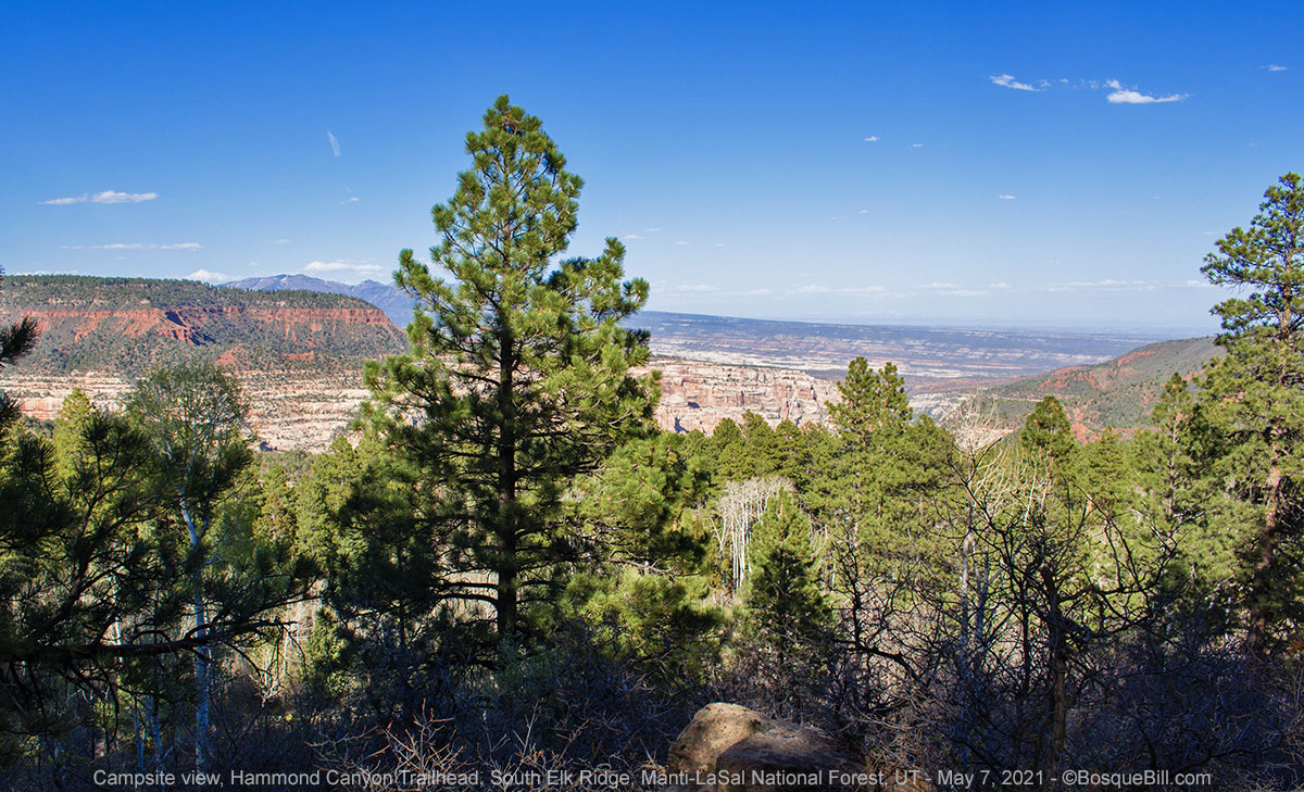 |
| Campsite view |
Saturday, May 8
South Elk Ridge (continued)
I had decided the night before I'd stay on at this lovely site today, so I set up my deployable solar panel. The campsite was deep in the trees so the roof panels would only get partial sun for part of the day. By moving the deployable panel around I could manually track the sun and hopefully replenish my batteries. This goal was somewhat hampered by clouds that moved in later in the day. Clouds really cut down on the insolation and reduce the ability to charge batteries.
 |
| Solar panel deployed |
I met my neighbors late the following morning as they were making their way to Hammond Trail to hike down and along the bottom. The trail is 6 miles long to the junction with two other trails up out of the canyon to the north and south. There had been two cars parked at the trailhead yesterday that were still there, so obviously some hikers do multiday trips. My neighbors, a nice couple from Telluride, were going down and coming back up before nightfall.
 |
| View of Hammond Canyon from above my campsite |
I took a leisurely hike down the trail only about a mile. Not far enough to get to the really steep part, still up in the trees. This early in the season (or late in my life) I was not in shape to go much farther.
 |
| The trail first drops down to cross a bench before reaching the canyon |
 |
| View of the canyon from the trail |
 |
| Mountain Goldbanner along the trail |
I enjoyed the late afternoon in camp, though the temperatures were dropping and a breeze was picking up. I know, I know - complain about the heat, then complain about the cold. I laughed at myself, but was concerned with the increasing clouds and what that would bode for my plans.
Sunday, May 9
South Elk Ridge (continued)
With my compressor fridge continuing to not operate properly and consuming too much charge, I was thinking of either heading home or spending just one more day in the Abajo Mountains by going north then taking Causeway Road across to the east. It was a very scenic drive, but the only time I'd gone that way there were lots of high clouds and what I refer to as a "dirty" sky - not good for photography.
The sky seemed clear first thing in the morning so I broke camp and prepared to go north. As I left the Little Notch area I came over a rise and could see a mass of clouds headed this way. No, next time, I thought and turned around to point the truck toward home.
Elk Mountain Road
I took the most direct way east though forested Elk Ridge then down into more open terrain along Elk Mountain Road, stopping a few times for photos.
 |
| The Abajo Mountains seen from Elk Mountain Road. |
 |
| Roadside lupines |
 |
| The spring-green cottonwoods make quite the contrast to the darker junipers |
The gravel road drops into Cottonwood Wash in Mountain Ute Trust lands, then turns south to meet up with UT-95. I headed toward Blanding. At US-191 I turned south toward Bluff, then took the unmarked bypass that is shown on the map as county road 216 to UT-162. From Montezuma Creek I returned home via the same route I'd driven out on.
I rate my first trip in over a year as a qualified success. I had had to change my (very loose) plans mid-way though due to unexpected high temperatures and shortened the trip due to power issues. I ended up with very long drives on a couple of days, but had also seen some beautiful scenery and explored some new territory. It was very good to get back out on the backroads.
In the time I've been home I was able to run some diagnostics and feel pretty sure the fridge is the root of my issues. I've been searching for replacement or service and a local RV service company, recommended by a friend, will look at it next week. I also took the opportunity to upgrade my solar charger/controller from the original PWM device to a Victron Energy SmartSolar MPPT 100/20 device with built-in bluetooth. MPPT is much more efficient in converting photovoltaic panel (PV) voltage into charge for the batteries. I will also be able to monitor voltages, power, current, etc via their phone app either in camp or on the road. That will be handy.
Thanks for coming along for the written portion of the trip.


