
First Post-pandemic Trip
New Mexico to Utah through Arizona to Utah and back: May 4 - May 9, 2021
You cannot believe how much I was looking forward to this trip - or maybe you can. I didn't even roll the camper out of the garage last year opting to stay home due to the pandemic. This wasn't all bad as I have a lovely yard near the Rio Grande and was able to enjoy my screened-in back porch. But still.
Click any photo to enter the enhanced photo-viewing mode with larger images.
Tuesday, May 4th
I didn't quite get it all together to make a shakedown cruise in April, so had the idea that my first night camping should be close enough to civilization that I could stop at a store the next morning for any critical supplies I'd forgotten and needed.
Angel Peak Senic Area
 |
| Edge of the cliffs with Angel Peak middle left. |
 |
| My campsite |
 |
| Angel Peak in the last of the day's sunlight |
There was cell & data service at Angel Peak, as it's in line of sight of Bloomfield.
 |
| Campsite from the air |
It was a very pleasant evening with only a mild breeze. I was able to enjoy the change in the colors of the formations as the sun sank in the sky.
Wednesday, May 5th
Angel Peak Senic Area (continued)
I did get this spherical panorama from the air that is quite interesting. Click the full page view icon in the upper right corner for the best experience.
 |
| I photographed Castle Rock as I drove out |
I stopped to take a photo of Ship Rock along the way.
 |
| Ship Rock |
The bypass drops me at the western edge of Shiprock and I only had to go one extra block to stop at That's-A-Burger (as popularized in the Hillerman novels under an assumed name.) Only their drive-thru was open, which suited me. I got a green chile cheese burger - yum! One day I need to try their fry-bread burger.
I took my usual route west on US-60 past Tec Nos Pos, then turning north at Red Mesa on the Navajo route that leads to Montezuma Creek. North from there on the backroads to the town of White Mesa which was under quarantine lockdown, but the automated pumps were open at the gas station there.
My goal this day was Arch Canyon north of Cedar Mesa. I'd camped there exactly two years ago and was blown away by how spectacular it was. View the Arch Canyon post with photos. I wanted to return to get a few more scenes to fill out a prospective video of the canyon that I felt was a bit light when I'd worked on editing it last year.
Unfortunately, the one prime camping spot at the canyon was very much taken. The other spot is just a place to pull off the road and not near to the view. There were several trucks parked at the turn around, too. Must have been lots of hikers. Nonetheless, I launched to try and get those scenes I'd missed before. I hope I got what I needed as it's hard to judge while on site.
I did get this spherical panorama from above the canyon that is quite spectacular. Click the full page view icon in the upper right corner for the best experience.
I drove back toward the highway with the hopes that my favorite campsite at North Mule Canyon was still available, but to my disappointment it was taken. It was still fairly early in the afternoon and the weather was clear and very warm. I decided I would not camp in a less ideal spot, but would continue on my way.
I didn't even bother to check the map as I knew roughly where I wanted to go. I'd always looked south at the Henry Mountains when driving UT-95 to or from Hanksville and wondered about them, though they looked desolate and dry. A few folks I'd met on my travels mentioned pleasant camping there and interesting scenery, so this was the trip I'd check it out.
At one of the places the highway passes near White Canyon below Natural Bridges National Monument I stopped for photos and got a nice one with the Bears Ears in the background.
 |
| The Bears Ears on the horizon behind White Canyon |
 |
| Cheesebox Butte a bit farther west |
As I zoomed past the turn-off to Fry Canyon I wondered if there is anything interesting to explore down that way. Do you know? The afternoon was getting warmer and the highway seemed to be stretching longer. I was glad when I finally crossed the Colorado River near Hite as I knew the turn off to Bullfrog and the Henry Mountains was just beyond there (well, a ways beyond there.)
 |
| Another landscape along the highway. |
I turned south and was happy to be driving into unexplored territory for me. As I passed a junction with a sign for the scenic byway I decided I'd better finally look at a map, so pulled off the highway and pulled out my Benchmark Atlas. The scenic byway looked like it could be long and rough, but there was a BLM campground in the foothills of Mt Hillers, Starr Springs. That sounded like a worthy goal and if I didn't like the campground I could explore the nearby roads for dispersed camping.
As I was driving toward the side road that would take me to Starr Springs I noticed how the foothills of Mt Holmes to my left were softly rounded sandstone while the peak was sharply angled.
 |
| Love how the foothills of angular Mt Holmes are wind-worn sandstone |
Starr Springs Campground
I also noticed, when I looked west toward where I thought the campground might be located, there was a patch of emerald green amid the sere landscape. "I bet that's the spring," I said to myself. The gravel road leading up the mountain was well marked and relatively smooth. Sure enough when I got close to the campground it was green, green, green. The campground is enveloped in a stand of oak trees and was very inviting. The BLM charges $10 per night; half off for pass holders.
I made one circle of the twelve sites, then backed into one I liked next to a VW camper van with Alaska plates - nice folks originally from SLC.

Besides the welcome shade and well groomed sites, the campground has fresh spring water, too. There are a couple hiking trails. Recommended if you're in the area.
Thursday, May 6th
Starr Springs Campground (continued)
 |
| Starr Springs Group Campsite |
 |
| Fremont Barberry can be found all around southern Utah |
 |
| Mt Hillers seen from the Starr Creek Campground |
Clay Point Road begins not too far south of the campground. My atlas shows it as an unpaved road, as opposed to a high-clearance 4WD road, so I thought I'd give it a go. There was a turn off to a dispersed campsite about a mile from the junction. It had a fantastic view, though it is totally exposed to wind and sun. I didn't include a photo as the view to the east put the sun directly into the camera lens and the view to the west is much like the photo below.
 |
| Junction of Clay Point Road (left) and Starr Springs CG Road |
The road was well maintained and scenic, if you lean toward the desert esthetic. I stopped a number of times for photos, and saw one pickup truck, in the hour and 45 minute drive to Burr Trail Road. The name changes from Clay Point Rd to Saleratus Wash Rd at some point, but the main route is clear, if not marked.
 |
| Coal Bed Mesa seen from Clay Point Road as I top the rise |
 |
| Dials Knob to the north |
 |
| Saleratus Wash Road crossing Bullfrog Creek |
 |
| Glimpse of the Water Pocket Fold facade from Saleratus Road |
Capitol Reef National Park
I was back on a route I'd done once years before, but was glad to pass that way again as it is so gorgeous. I took many more photos including some views of the famous switchbacks that are probably the same as I featured in that earlier blog post.
 |
| Western facade of Water Pocket Fold near Headquarters Canyon (3 photo pano) |
 |
| This is where the Burr Trail Switchbacks climb up and out |
 |
| The red slope is where the switchback are dug in |
 |
| Looking back down the grade |
 |
| View from the top of the fold with the Henry Mountains in the background |
A reminder to fellow travelers, there is no dispersed camping in Capitol Reef National Park. It is allowed in Grand Staircase/Escalante National Monument, however you are supposed to get a free permit first. Permit forms may be found at some of the kiosks located where side roads leave the highway. Or you can get them at the information centers. You don't have to specify the exact camping spot, the rangers will allow a general area. I was told a few years ago that if a ranger comes upon you camping without a permit, they will issue you... a permit.
Grand Staircase/Escalante National Monument
When Burr Trail Road leaves the national park it becomes (controversially) paved. I'd like to explore the Wolverine Loop Road, south of the main route, sometime with a hike of Wolverine Canyon and the adjacent petrified wood area. Another time and in cool weather.
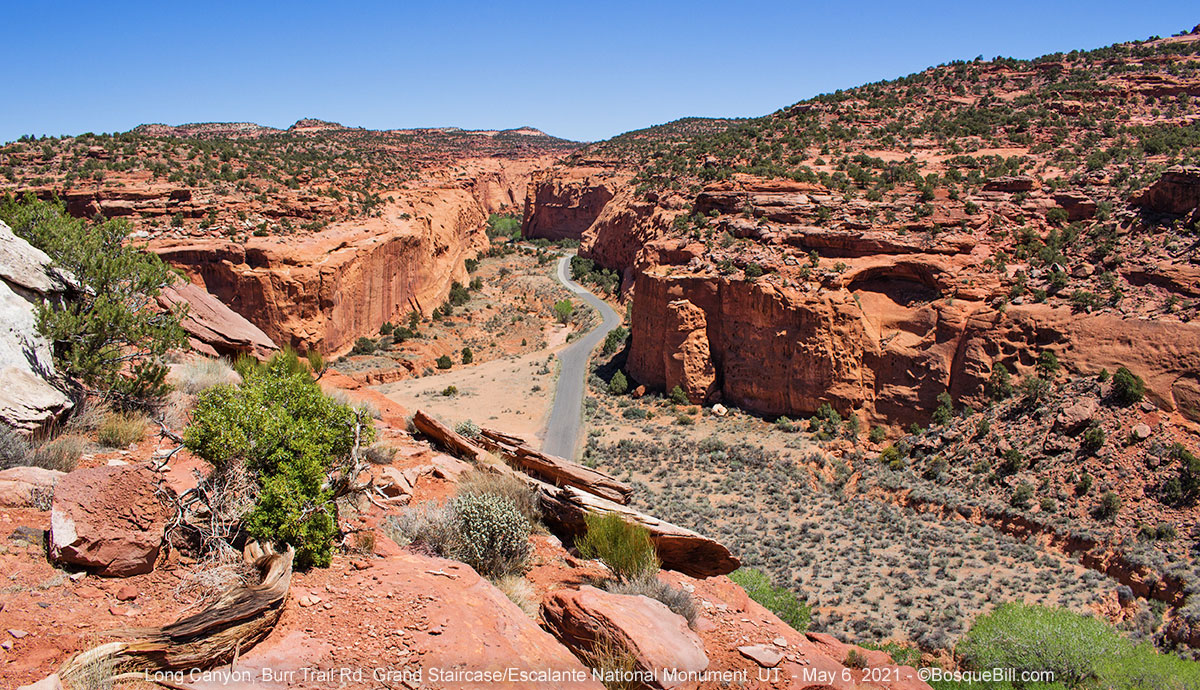
The paved road, after crossing the flats, drops down and proceeds though Long Canyon. Curiously, it didn't feel as long this trip.
 |
| North end of Long Canyon |
 |
| Fracturing that can lead to arches |
 |
| There are very few pull-offs along the canyon |
 |
| Looking back after climbing out |
Back on the highway, through the town of Boulder then south on UT-12, I stopped to get aerial views of the dramatic Hogback.
 |
| Hogback on UT-12 south of Boulder |
 |
| Calf Creek Canyon as seen from the location above. |
Please join me in part 2 where I explore new territory in Grand Staircase/Escalante National Monument.
I had a nice drive down Burr Trail Rd this spring for my first trip to Utah in 35 years. I’ve got a lot more to see so I will return, hopefully as soon as it cools off. Utah is a lot more crowded than it was 35 years ago, it was kind of shocking. Not sure if that is a pandemic thing or a boomer thing. We will find out.
ReplyDeleteCharles, thanks for commenting. Yes, all the backroads are much more trafficked these days. And some camping areas that were lonely years ago are too full to even find a space nowadays. I think it's mostly due to increases in population in the western US. On the other hand, National Parks are full of visitors from afar.
ReplyDeleteMein Gott!! Your photos are SPECTACULAR!
ReplyDeleteSo then I went to the Mavic2 Pro website and my esteem shot up ANOTHER degree of magnitude when I saw it has a Hassleblad camera.
Holy Cats...and congratulations!