continued from Part 1
Part 2 of 4
Tuesday, September 18 (continued)
South Spring Creek
 |
| Brown Lakes State Wildlife Area |
From Middle Creeks, I drove northwest on CO-149 and took South Spring Creek Road, FR-515, toward Brown Lakes State Wildlife Area. About a mile in from the highway a view of the valley opens up. The western slopes were very pretty with aspen and rock cliff faces. I pulled into a fishing access parking lot to look around and take photos. As I was walking back to my truck I just happened to notice a shimmering in a cleft in the cliff a few hundred feet north of the road.
 |
| Waterfall on Porcupine Creek |
I found a double-track that led that way and sure enough found a little waterfall - actually it was more like a steeply slanted rock face the stream was flowing down. I had to clamber up a narrow trail to get photos.
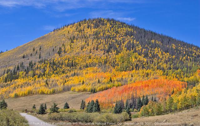 |
| Near the junction of Trouble Hill Road |
 |
| A closer look at that blaze of aspen at the foot of Trouble Hill |
A few miles down the valley the road is closed to the public, but there is a junction to FR-516 that heads up hill just before the gate. There was an amazing red/orange grove of aspen at that point. After taking a few photos I drove up 516, which I later learned is called Trouble Hill. A fertile imagination can picture various reasons for the name - none of them much fun for those folks.
 |
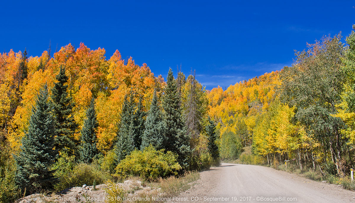
| Trouble Hill Road |
The road then skirted the edge of a large park. Recall that wide valleys/meadows are called "parks" in Colorado. I spotted a couple of sideroads that probably lead to dispersed camping, but kept driving. A sign earlier had warned of logging trucks and I began to see evidence of logging. Apparently the spruce beetle had hit this area hard some years ago.
FR-516 ends at a gate to a private residential area along a lake. Lots of trucks with trailers were parked at a lot just before the gate. This is apparently one end of ATV route to Lake City. I explored up a side road to look for future camping areas, but it wasn't a very pretty area.
I drove back on FR-516 and took one of the side roads I'd seen before along the upper edge of the park. I crossed Mason Creek that was barely a trickle and found a nice spot for a picnic with a view.
 |
| View from my picnic spot next to Mason Creek |
 |
| View as I drove back down Trouble Hill Road |
 |
| Cliff face next to Brown Lakes |
I drove back to highway and turned north. In a couple miles I turn off onto a roadside overlook. Other times I'd driven by it was too hazy or the light was poor, but this time the view was spectacular.
 |
| View from overlook of Brown Lakes and Weminuche Wilderness |
Information signs at the overlook:
 |
| Another view, a bit wider, from the overlook |
North Clear Creek Fall
I continued northwest on the highway and took the short paved side road east to the North Clear Creek Waterfall. I'd gotten nice pictures of it before, but wanted to admire it again.
 |
| North Clear Creek Falls. Those mountains in the background are near my next stop. |
 |
| This Vesper Sparrow was hanging around the picnic table next to the parking area. |
 |
| A gif made from a Live Photo |
North Clear Creek Road
From there it is a very short jog on the highway until the turn off west for FR-513, North Clear Creek Road. The road crosses an open prairie, passes through a nearly derelict guest ranch and then forks.
 |
| The road to the Continental Reservoir. |
First I took the left hand road that leads to the Continental Reservoir, FR-513.1A, that follows North Clear Creek to the reservoir. It was gorgeous with colorful aspen along the valley slope. There was a dirt track that lead down to the creek where you could likely camp, as it is all national forest along here. Just before the road climbs up the dam was a cabin that is not open to the public, something to do with the dam perhaps, but made an interesting photo.
 |
| Cabin at the foot of the dam |
Up on the dam the wind was really howling. You can see the affect it had on the lake surface. There is a small parking area with a clean vault toilet, but that's about it. The water level was very low. I turned back down the road to check out the other fork.
 |
| Continental Reservoir |
Rito Hondo Reservoir
This lead to Rito Hondo Reservoir. There were quite a number of folks fishing here. There is a large, open dispersed camping area, as well, but no one was camped there - perhaps as it has no trees, so is exposed to the wind. Probably used more frequently other times of the year. There is a 4WD trail that leads north though wooded areas. I didn't explore up that way, but suspect there may be nice dispersed camping up that way, assuming the road doesn't get too rough.
 |
| Rito Hondo Reservoir |
All the times I'd seen people fishing on my trip I'd stop and ask them if they were having any luck. So far none were. But here I saw a couple of men walking back to their trucks with an impressive catch of large trout. I asked if I could take their photo with the fish for my travel blog and they agreed.
 |
| What a catch! |
Forest Service Road 788
Back to highway, I drove over Spring Pass, then Slumgullion Pass, and turned off onto FR-788. The Slumgullion Pass Campground is located at that junction, but it has been closed to the public for a few years as it has been used for the headquarters of the logging project to clear the many square miles of spruce beetle destroyed trees in this area.
The road travels north though a shallow valley formed by Mill Creek, then narrows. Other small creeks merge into the valley that soon becomes a canyon with steep, rock cliffs. I came upon two cowboys herding a bull down the road.
 |
| Keep right except to pass! |
 |
| Looking down/ahead FR-788. |
 |
| There were interesting rock formations along the road. |
There are a few small dispersed areas and a few small campgrounds that were closed. One that was open, was the Hidden Valley Tent Campground down a short, side road. It is a lovely dispersed tent campground next to the stream with grass, cliff view, picnic table, fire ring and vault toilet. There is a parking area for 3 or 4 vehicles, with campsites on the other side of the stream accessed via a foot bridge. It would not be ideal for a pop-up camper, but could work and is pretty. I believe there is no fee for camping here.
 |
| Access road to Hidden Valley CG; one campsite; foot bridge to another site. |
 |
| Cebolla Creek seen from foot bridge at Hidden Valley Campground. |
 |
| Tent site and parking area seen from foot bridge at Hidden Valley Campground |
When I continued down the canyon I came upon a large herd of cattle being driven down road. There was really no place else for them to walk, so we had to wait it out until we could ease through. I passed another small campground, situated next to the stream, and there were a number of campers.
 |
| Heavy traffic ahead; proceed with caution! |
 |
| Road narrows. |
 |
| More scenery along the road. |
There were more dramatic cliffs, then an open valley of range land, part of a private ranch. There was a little more public land, then a junction at Cathedral Creek. Initially I had thought I'd go north here up the county road through BLM land and meet back up with CO-149, but at the last minute I decided to keep on FR-788 and head up toward Los Pino Pass. The sign indicated that it was 29 miles to CO-114, which which would then lead to Gunnison. Cool.
Los Pino Pass Road
FR-788 from the junction lead down a valley, but then you need to turn uphill to avoid private land. A sign reads “4 Miles of Narrow, Winding Road.” The road climbed up about 2 miles then made a wide bend to the right. Just after making the bend I noticed tracks leading off north behind me. I did a K turn and found the tracks.
 |
| My campsite just off Los Pino Pass Road. |
In only about 100 feet they led down to a beautiful grassy area, a dell out of the wind. The grass was very dense, like carpeting, there were no cattle, no wind, nearby interesting rock formations, and nice views so decided to camp here. According to the map, this was BLM land, so no problem.
I set up camp then sat outside, I took a few photos, and enjoyed the warm late afternoon sun. Once it moved behind the mountain, it got chilly, which drove me in.
I thought at 9300 feet it wouldn’t be as cold as night before.
Wednesday, September 20
Boy was I wrong, morning temperature was 16º! Still my camp was situated to get early morning sun and it soon warmed up.
 |
| Morning at my campsite. |
 |
| View through the gap next to my campsite. |
 |
| View from my campsite looking toward the pass. |
I drove up FR-788 toward Los Pino Pass. Part way up the view back to the west was so spectacular I actually exclaimed “Wow!” out loud. I pulled over and took photos.
 |
| Westerly view from the road. |
 |
| Looking southwest from the road. |
 |
| Almost the same view as above. |
 |
| Here's the view with my rig - as close as I get to a selfie on this blog. |
The road was pretty good, but with rocky patches. Up at the pass, which is back in national forest lands, there were lots of hunters in large trailers camped in the meadow on top. Down the east side there were large stacks of logs - spruce beetle casualties awaiting transport.
 |
| The road entering ranch country. |
 |
| A female Mountain Bluebird was hunting from this perch along the road. |
There were side roads along this stretch and lots of opportunities for future explorations. As the road dropped the land opened up into ranching country, location of the Old Agency Ranch. From here the wide, gravel road skirts the basin and joins the highway, CO-114. I turned north.
 |
| Cochetopa Canyon |
Highway 114 quickly dove into Cochetopa Canyon. This small, twisty, narrow canyon was very scenic and as I was stuck behind a diesel-fume belching RV, I pulled over for a photo. After a few miles the canyon opened into a valley and in about 15 more miles reached US-50, which I followed west to Gunnison.


No comments:
Post a Comment
Thank you for taking the time to comment. I really appreciate it!