
Note: If you click on a photo you can see a larger version - highly recommended.
Wednesday, October 2 (continued)
I drove straight north though Ridgway and Montrose. I stopped for gas in Delta where I took CO-92 to the east. The highway passes to the south of Grand Mesa and I could see yellow aspen high on its flanks. I took the left fork for CO-133 at Hotchkiss. The turn-off to Kebler Pass Road (County 12) is just before Paonia State Park, not to be confused with Paonia River Park. The junction was poorly marked and I almost missed it.
Kebler Pass Road
Though I'd driven by it a number of times, I just noticed the Erickson Springs Campground at the sharp bend before the road begins to climb. I didn't stop, but it looks like a pretty, small USFS site with great views situated right on Anthracite Creek.
 |
| Ragged Mountain was beautiful with its skirts of autumn color. This photo was taken from the road only a short way up the mountain side. |
 |
| Another view of Ragged Mountain, and of Ragged Peak (to the left.) This photo was taken from the overlook where the road reaches the top. |
It was nearly 4:30 by the time I started climbing the road into the Elk Range and Gunnison National Forest. The views were gorgeous and I stopped many times for photos. The oaks were already brown, but the aspen groves ranged from 30% to 60% golden.
 |
| There were great vistas to the south of the road of the Beckwith Mountains. |
 |
| Farther east along the road, Marcella Mountain shines on the north side of the road. |
Lost Lake
I took the side road, FS-706, toward Lost Lake. If I remembered my previous visit, the sun would be behind the mountain on the far side of the lake, so the light might be poor for photos, but I wanted to look. There's a small campground at the lake and if I could get a good spot I'd camp there and be ready for the morning sun on the lake and surrounding peaks.
 |
| The road to Lost Lake |
As I drove up I took note of many dispersed campsites along the road. Some were right next to the road and would be very dusty, but others were farther back. If there was no room at the campground, or I didn't find a site I liked, I would return to one of these.
As I expected the sun was behind the mountain, but there were aspen in the sun and their reflections in the lake.
 |
| Lost Lake |
There was one site available in the campground, a pull-through right next to the road. It was not to my liking so I drove out and back down the road. I found a great site well off the road in a thick grove of spruce. But the trees were so densely packed that they blocked off the satellite radio signal. I couldn't camp there and listen to the baseball playoff game that night, so continued back down the road.
 |
| The road leading away from Lost Lake |
It was almost 7pm by the time I found a more compatible site and got set up. I missed the first couple of innings, but the site was quite nice and far enough from the road to be out of the dust.
 |
| My campsite along Lost Lake Road. |
 |
| Colorful leaves next to my campsite |
Thursday, October 3
Wow, it was extremely cold in the morning, 17ºF as I recall, so I wasn't eager to get out. I read a bit and drank coffee until it at least got above freezing. I broke camp and headed back toward the lake at about 10am.
Lost Lake
The sun was shining on the Beckwith Mountains and I got a pretty photo. The wind had already disturbed the surface of the lake, so no reflections.
 |
| Lost Lake with the Beckwith Mountains in the background. |
Kebler Pass Road
I drove back to the main road and headed east. I stopped several times for photos, both from the ground and from the air. There were quite a few cars and trucks on the road with lots of folks also stopping for pictures of the colorful foliage.
 |
| Aspen grove |
 |
| East Beckwith Mountain |
Even just looking at the view from the UAV camera on the phone screen showed amazing vistas and when home and on the big computer screen they were amazing. I especially like those that show the uneven terrain and Ruby Anthracite Creek.
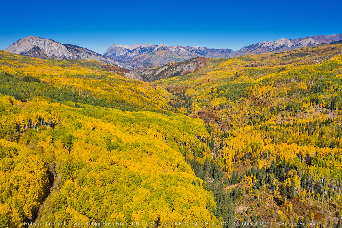 |
| Ruby Anthracite Creek valley |
At one point I pulled off into a large aspen grove. I was hoping to find the spot I camped several years ago and get some aerial images from there.
 |
| Looking down into an aspen grove |
 |
| Ruby Peak as seen from Kebler Pass Road |
 |
| Striking red foliage below a rocky ridge of Ruby Peak |
I took spherical panoramas from a couple of locations, but have only posted this one.
I stopped for a picnic lunch at Horse Ranch Park where there were a number of 5th wheels and travel trailers camping. This was also a popular place for photography due to the view from near Ruby Anthracite Creek. After a few more photos and a short flight, I continued east.
 |
| East Beckwith Mountain |
 |
| Ruby Peak from above Horse Ranch Park |
There are a few nice views from a couple miles east of Horse Ranch Park, but go much farther and you get out of the aspen groves. Should I double back or go on? In years past I remembered wonderful aspen in Gothic Valley north of Crested Butte, maybe I should check out that area. Also, though the skies remained clear, the forecast was for clouds and rain the next day. Perhaps it would be better to head toward Taylor Park so I could escape over Cottonwood Pass, that was now paved, if the weather turned bad. It was a straight shot from there toward home. Besides, I felt I'd gotten great photos of all the major areas along Kebler Pass Road. Onward and upward!
Crested Butte and Gothic Valley
 |
| Crested Butte: mountain and town |
So I kept going east to Crested Butte, then drove north though the resort village of Mount Crested Butte to Gothic Valley. Once in the valley it didn't take long to realize the aspen were well past prime in this area. I drove past the research station hoping there might be good color farther up, but stopped after crossing the creek. There was a little color there so took a few photos for good measure, then turned around and headed south.
 |
| White Rock Mountain and the East River in Gothic Valley |
 |
| Washington Gulch |
Journey continues in Part 4.
No comments:
Post a Comment
Thank you for taking the time to comment. I really appreciate it!