Continued from Part 2
Fry Canyon Ruins - Moss Back Road - Red Canyon
October 14th (continued)
Fry Canyon Ruins
Those who read the blog post for my May trip earlier this year may recall I spotted a sign for Fry Canyon Rd which Google called Fry Canyon Ruins road. I did not explore it at the time. I decided to check it out this trip since I was going to be nearby. The road sign is gone. This short road crosses an old airstrip (which looks like it would be a disaster zone if any pilot had to use it.) There are a couple of dispersed sites along the road, one which was occupied by two trailers while the campers were apparently off exploring. The road deteriorates before the end and high clearance is necessary. You can pull off before that point as it's not that much farther to walk.
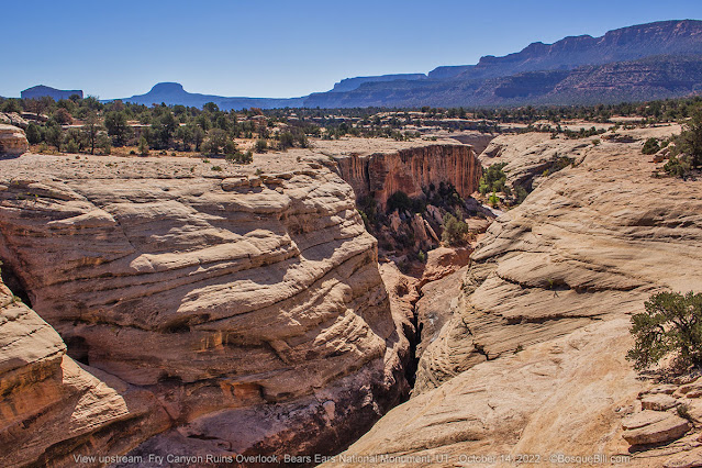 |
| The view up Fry Canyon from the overlook. |
 |
| The view down canyon. The ledge mid-way down on the far side leads to the ruins. |
The ruins, cliff dwellings, are clearly visible from the rim of the narrow canyon, but were in shadow. I tried to compensate for this during photo post-processing. I saw no way down into the canyon from this side of the canyon.
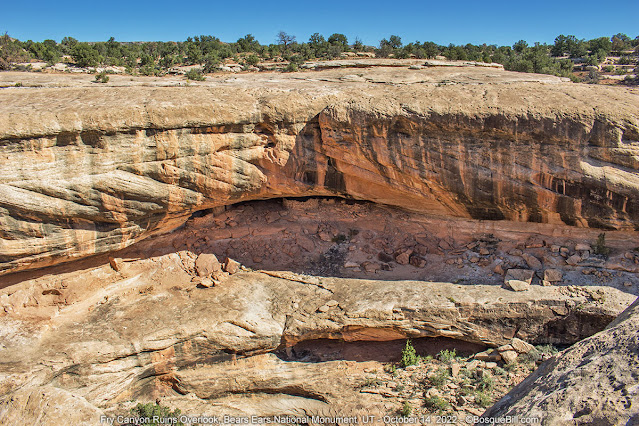 |
| Fry Canyon Ruins. |
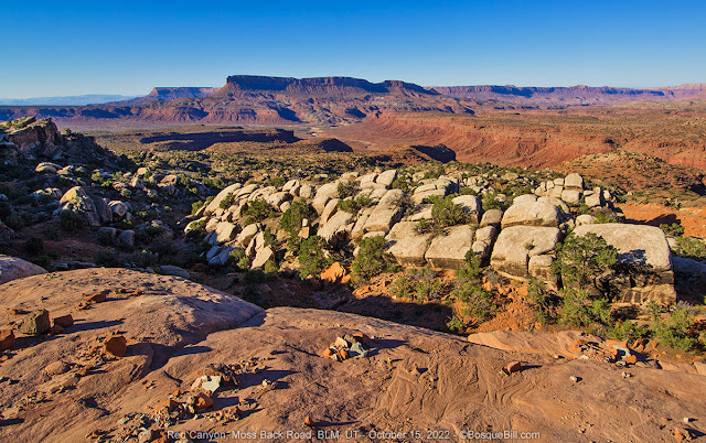
Moss Back Road
Back on the highway I took the turn south on Radium King Road. The road had been washed out in several places in the recent past, but the county had come through and made complete repairs. For a more detailed description of the road, with photos, see my earlier post. I turned onto Moss Back Road. Though this road had not washed out, there were many, many places where flood waters had washed over the road - not enough to block travel, but I had to slow the truck to a near standstill multiple times to cross without impact.
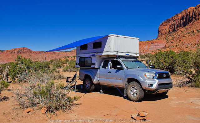
I really liked my previous campsite, but wanted to try another location. I drove for a couple of miles, creeping over the washes. I found an interesting site off the road, a little ways from the rim. I figured out a level spot with the side of my camper where the fridge is mounted on the north side as the sun was hot even with mild temperatures.
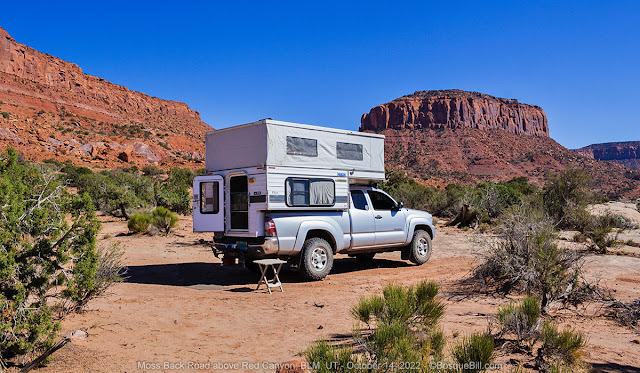 |
| My campsite. |
One of the nice features of my campsite was a nearby ancient juniper. There was plenty of room underneath in the shade to set up my chair - a rare treasure indeed to find in arid Utah. I sat in my chair, enjoyed a cool drink, and gazed out over Red Canyon.
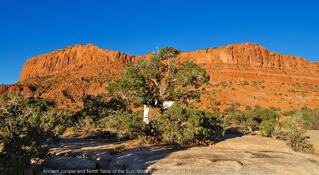 |
| This juniper was the largest I saw anywhere around. |
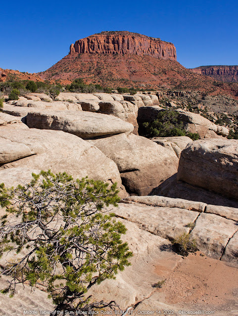 |
| Looking along the rim of Red Canyon toward Tables of the Sun Middle. |
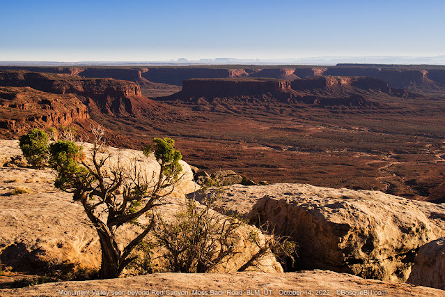 |
| Red Canyon looking toward Monument Valley. |
 |
| Another photo of the edge of Red Canyon. |
As the day moved into the golden hour, I wandered about taking a few photos. There were no clouds, so not much sunset photo potential.
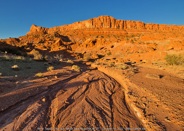 |
| Looking up a recent rain wash toward North Tables of the Sun. |
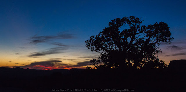
 |
| No traditional sunset, but I loved the look of the ancient juniper against the darkening sky. |
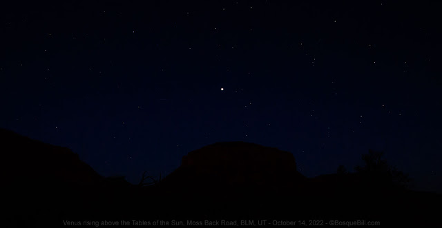
I suddenly realized I should try to shoot the sky when it got truly dark. I got out my tripod and my camera for which I had a remote shutter release. I set that up and remembered I needed to set focus on infinity while there was still light enough to see. Venus was up by that time and I tried a couple of exposures. With a little tweaking in Photoshop one of those turned out pretty well. (Photographers, I was able to use Live View with magnification to dial in my exposure; then gaffer tape to hold it for night shots.)
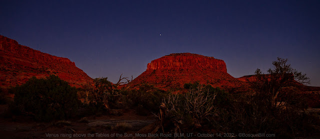 |
| Venus rising over Middle Tables of the Sun butte. |
 |
| You may need to click the photo to enter the lightbox viewer to see the stars. |
I was disappointed when I looked at the photos to discover the Milky Way was simply too faint for my 10 year old camera sensor to capture. Maybe I should have tried a wider aperture and might have the following night except for (spoilers) there were clouds, so I didn't even try. I did try my hand a light painting using a bright red LED flashlight.
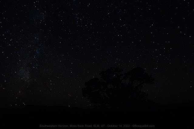 |
| The Milky Way faintly shows on the left side of the photo. |
 |
| My first ever attempt with the "light painting" technique. |
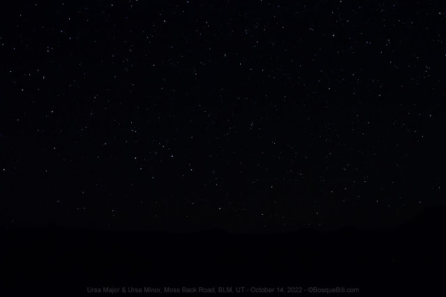 |
| The Big Dipper (bottom center) and the Little Dipper with North Star. |
October 15
Moss Back Road (continued)
 |
| Early dawn at the campsite. |
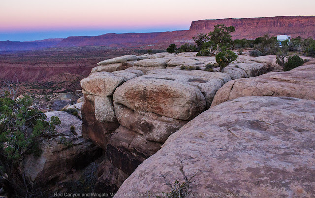 |
| Looking east along the rim as the sun begins to lighten Wingate Mesa. |
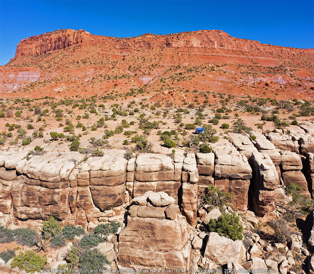
A gorgeous early morning. I took a few photos, then later walked north along the road.
 |
Here an entire section of the rock bench subsided into Red Canyon.
You can also see patterns in the foreground where water flowed over the edge in the storm. |
 |
| Red Canyon. Sure are a lot of photos of rocks in this post. |
One thing I noticed was that the heavy rains seemed to have severely damaged the cryptobiotic soils washing away much, or sometimes most, of the protective crust. My hope is that the microorganisms are still present in the soil and will be able to recover before more erosion of the soils can occur. I took a photo to show you, but perhaps unsurprisingly it just looks like a picture of dirt.
Though I loved this new campsite and enjoyed gazing at the view for hours, I don't think it's quite as photogenic as my earlier site. So I again encourage you to view my previous blog post on this area.
After lunch I "raised" my home-made awning. It is not nearly as convenient as the permanently mounted awnings, but it has one big advantage. I attach it at the roofline so it shades the entire side of the camper - all the mounted units I've seen on pop-ups are at the top of the hard side, so the soft sides and windows still get full sun. My awning shades the entire camper keeping it cool enough inside for an afternoon nap! Of course in a situation like here there is not enough soil for staking the pole guy lines, so had to use either conveniently placed dwarf trees and large rocks. But those worked very well as a substitute.
 |
| My cheap home-made awning with guy lines anchored with rocks. |
I took my drone up in the afternoon to capture a panorama and some images of my campsite. The spherical panorama was not nearly as good as the image set I got last spring which show the colors much better. I encourage you to view that panorama and pan around at the scene. I did get a more traditional stitched panorama of the mesas and buttes, and a shot showing my campsite.
 |
| Wish I'd panned down a bit more, but you get the idea. |
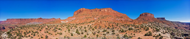 |
| Multi-exposure horizontal panorama. Click for larger view. |
High clouds started moving in during the late afternoon. Looked like the weather forecast was going to be accurate. At least, I thought, there would be clouds for a spectacular sunset.
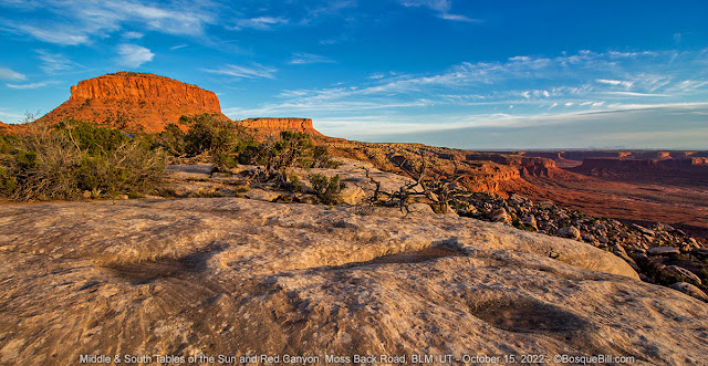 |
| Middle & South Tables of the Sun and Red Canyon as the sun goes down. |
 |
| The clouds didn't really cooperate, so this is the best I could do. |
October 16
Moss Back Road (continued)
No photos today. It was breezy and cloudy when I got up per the forecast, so simply packed and broke camp. On the way out I saw two "campsites" close to Radium King Road were occupied. I was surprised they camped there rather than driving just a little farther and getting the full view. Both had vehicles that could have easily driven the road. Whatever.
Homeward Bound
I made my way down to the highway and turned east. One benefit of the cloudy morning was that I didn't have to stare into the sun as I drove.
I took the "northern" route across the top of Cedar Mesa, crossing Comb and Butler Washes to the highway south of Blanding. Red Mesa had relatively inexpensive gasoline, and my gauge was nudging E, so I filled up. I took my usual short cuts down through Montezuma Springs and Red Mesa Road. I was feeling hungry by the time I made New Mexico so stopped at the little C store in Beclabito. They have a hot cabinet full of locally made burritos, chimichangas, corndogs, etc. I got one red and one green chili baked burrito. Hit the spot.
My usual route from there. Looked like it had been raining in Albuquerque and I drove through a light storm once I got close. Made it home safe, but had to unpack in light rain and coldest temperatures of the entire week. No worries, I was home safe after a great trip, and looking forward to a hot shower.
Thanks for coming along on my fall trip to Utah.


30 secs at 3200 ISO on a relatively new camera, then pulling it out in Photoshop, will get you something. Or less, even if bright stars and peak Milky Way. Summer, Rocky, Milky Way and astronomy: https://photos.google.com/share/AF1QipNoqQBOKCC5IY3uGaWoNcsg22LuwcsnOaaOWTM0H9FsyHk0EoJSBml3ct7vaTDSsw?key=dl9ucDVGajFnY013SVdoRmROMUNtY0VkTkVtWXZ3 Stars only, no Milky Way, this summer, Bisti: https://photos.app.goo.gl/fGTov6SytVfQQQVg7 Less than that works if it's brighter stars and not the Milky Way: https://photos.google.com/share/AF1QipMdvI8LObs91HUQfJMNKyxklocC8s_phHfkxtA469DKfmZBNqWX7fiYShx1MO-uvg?key=bldsSWNOdkJ1cTFEM1NSV05FVkp4dUdLNTNyNmFR
ReplyDeleteThanks, Gadfly. My sensor is just too noisy at 3200 unlike new cameras. I keep thinking I'll build a motorized equatorial mount, but haven't got 'round to it yet. Thanks for sharing your photos!
DeleteBill, thanks so much for your trip reports! They are among the best, and I look forward to seeing the next one. Well done, Sir!
ReplyDeleteThanks! I was just made aware that I wasn't getting notified when folks left comments, so am going back through plus adjusting my settings.
DeleteBill!
ReplyDeleteThis is a great post! I'm a few miles south of Camp Verde in Arizona heading for Utah and this is EXACTLY what I was looking for.
It seems as if everywhere has gotten crowded so I can't bring myself to disclose the occasional spots I find, but I appreciate your clear directions and descriptions of road conditions. And, of course, most of all, your great photos!
How're you doing? Are you oot & aboot (out & about)?
Thanks! I was just made aware that I wasn't getting notified when folks left comments, so am going back through plus adjusting my settings.
ReplyDelete