You can see a larger version of any photo by clicking on it. Then you may use
the arrows to move from one photo to another.
September 14 - 20, 2022
After my wonderful Utah expedition in April of this year I was eager for my
next trip. Life, however, intervened. It was just one thing after another
and I'll spare you the gritty details. My schedule was clear to hit the
road after Labor Day and I began preparations for camping in the San Juan
Mountains of Colorado. Then I had to delay my departure by several days to let
rain storms clear out. OK, now let's go...
Wednesday, September 14th
Angel Peak Scenic Area
My goal for this trip was Alta Lakes, south of Telluride, Colorado. The forecast
indicated that one more day was needed for the rain to fully clear out, so I
took off late in the afternoon with Angel Peak in northern New Mexico as my
destination for the night. It's only about a 2-1/2 hour drive NW on US-550.
There were thunderstorms nearby my route and I got to see a double rainbow as
I was coming into Cuba. I arrived at Angel Peak near dark and set up at my
favorite spot. This is my fourth and shortest stay. Click "Angel Peak Scenic
Area" in the location column to the right if you want more story and many more
photos.
Thursday, September 15th
I didn't waste any time in the morning. I snapped my obligatory campsite photo
and hit the road.

|
|
Angel Peak campsite
|
I took my usual shortcut across the Navajo agricultural lands to skip the
traffic in Bloomfield and Farmington. Email if you want the route details.
Ship Rock
It was a sunny morning and the atmosphere was particularly clear due to
yesterday's rains. It was a good morning to photograph Ship Rock, so when I
came out on the highway formerly known as 666 I turned south instead of toward
Colorado. I took the side road that leads to the air strip, stopping a couple
of times on the narrow shoulder for photos. I think this one turned out particularly fine.

|
|
Ship Rock on the Navajo Nation
|
I turned around, headed to Shiprock and filled my gas tank. I drove north into
Colorado stopping for tacos in Cortez before heading to Dolores and the San
Juans. As I drove up the east fork of the Dolores River it was cloudy and
dark, but no rain. I didn't stop for photos as there are plenty from earlier
posts if you're interested.
Alta Lakes
I turned off onto Alta Lakes Road (Closed winters). It's nowhere near the
worst road I've bumped over, and it's not technical at all, but it's a slow,
tiring 45 minute drive. Not suitable for trailers and high clearance is a good
idea, though a careful driver would be able to negotiate the road in a
passenger car.
At the campground I wasn't surprised my favorite site was already taken, as
was the site I considered #2. In looking around for an alternative I couldn't
help but notice that a number of the sites had a large mud puddle in the
middle of where you'd park your vehicle. Evidence of all the rain in the last
several days. I found a site with a dry, level spot for my camper. It was a
little closer to the chemical toilets than I'd have preferred, but otherwise
wasn't bad and not too awfully far from the lake.

|
|
My first night's campsite - you can just see the lake through the trees |
After setting up I wandered a bit, took a few photos, then scurried for the
camper when a light shower came through. Later I walked through the campground
and stopped to talk to the two couples who were camped in my favorite spot.
Very nice folks. I asked how long they were staying, if they didn't mind my
asking. "We're leaving in the morning," they replied. I expressed a desire to
move to their site when they left, which they were fine with, and they told me
they'd probably leave around 9:30 in the morning. I asked if anyone else had
enquired and metaphorically called "dibs."

|
|
Lower Alta Lake with Palmyra Peak in the background
|
There were wonderful sunset colors on Palmyra Peak and reflected in the lake.

|
|
Beautiful color near sundown
|
The campground was very busy on this Thursday night with lots of folks looking
for sites. I think a few people stretched the rules a bit on where it was
legit to camp. I certainly ended up with a lot of neighbors and some were not
exactly quiet. I learned many campers were here for the Telluride Blues & Brews festival.
Friday, September 16th.
In last year's Alta Lakes post, I go into much more detail, so read that post, as well, if you are interested in coming to
this spectacular location.

|
|
Male first year Red Crossbill molting into adult plumage - getting a drink in a puddle |
I was able to move my camp to my favorite spot. I love this campsite. It has a
commanding view of the lower lake, the surrounding forest, and the dramatic
surrounding mountains -- the best view of any of the sites. It is also fairly
level and I can park where the sun shines on my rooftop solar panels for much
of the day, yet there is shade around the site and trees to enjoy. Sitting in
my comfortable chair I can bask in the beautiful view for hours letting all
cares of civilization slip away.
The photo below is not from my campsite, but from one of my wanders along the
lake.

|
|
I loved the tranquil beauty of the shoreline.
|
That afternoon another FWC pop-up camper, a Hawk model, pulled into the site
just past mine. That evening I saw they were building a campfire so I brought
them the few pieces of wood that had been left at my site. K & J are from
Fresno, and although they have had their camper for a little while, they were
on their longest camping trip so far and were stopping at all their
bucket-list locations. We had a pleasant conversation about camping and our
campers as we enjoyed the campfire.
Saturday, September 17th

|
|
Dawn clouds reflecting in the lake
|

|
|
Looking up at my campsite from the lakeshore
|
Mostly cloudy again this morning, but no rain at least. I spent the morning
enjoying the view and jumping up, from time to time, to try (mostly
unsuccessfully) to photograph various of the wild birds that were flitting all
around.

|
|
This little chipmunk paused to allow a photograph
|

|
|
A ubiquitous Junco posed for a moment
|

|
|
Once it warmed up the damselflies came out to bask in the sun.
|
In the afternoon I hiked up to and around what's called the upper lake, but is
really the middle lake. I didn't even realize it was there last year until I
saw the spherical panaroma taken by my drone. It was an easy hike, though if
you are unacclimated to higher elevations, you might want to take it easy.
Alta Lakes is at 11,300 feet elevation. The road to the upper lake is only for
residents of the few summer homes and The Observatory lodge (which was
apparently rented out to a wedding party this weekend).

|
|
The upper (middle) lake
|

|
|
A view of my campsite from across the lower lake (at 70mm)
|
That evening I met C & B, an interesting young couple from Denver, tent
camping from their Jeep in the next site. They'd moved from Maryland within
the last two years to be closer to all the wonderful outdoors opportunities we
enjoy in the west. We had a delightful conversation about camping sites and
scenic locations.
Sunday, September 18th
There was a little color in the dawn sky today.

|
|
Early morning light
|
I tried my hand at more wildlife photography around the campsite with better
success than yesterday.

|
| Northern Flicker |

|
| Mountain Chickadee |

|
|
Pine Siskin - there was a whole flock flitting around a tree that had
fallen over into the lake
|

|
|
Gray Jays (aka Whiskey Jack) are not shy, but difficult for me to
photograph
|

|
|
A Paddle-tailed Darner in an extremely rare moment of repose
|
I took my M2P up for a short aerial photography session. I took a spherical
panorama, but the one I took last year is a bit better, so I'll link it here
instead of the new one.
Alta Townsite
In the afternoon I hiked down to the Alta Townsite. (The road to the lake
goes right through the townsite, but a hike is much more pleasant endeavor.)
I'd seen on my map there is an official trail from the campground to the
townsite. I'd also noticed small trails leading off the ridge behind my
campsite that I thought might meet up with the actual trail. I walked down
one of those and thought I was doing good as it turned in the right
direction once off the slope, but then it disappeared. I kept going in the
same direction, overland, and after a bit came to the real trail. I
recommend you take the official trail all the way.

|
|
First glimpse of the townsite from the trail
|
It is a lovely trail alongside a bit of a running brook. It comes out on the
old Boomerang Road (now closed to motor vehicles) just north of the
township. I wandered around the ghost town taking photos and admiring the
view. Apparently there was not mine here, rather this was where the workers
at the Gold King Mine lived. More info just below.

|
The magnificent view of Sunshine Mountain from Alta Townsite
Lizard
Head is on the left; Wilson Peak on the right
|

|
| Alta Townsite |
The hike back up the trail to the campground was again beautiful and I
confess to stopping a number of times to catch my breath. The terminus of
the trail is just before where the road turns off into the campground. There
are a few other trails in the area; the Boomerang trail is suitable for
hiking or biking and leads to trails in the Telluride Ski Area.

|
|
The trail from the townsite back to the campground
|

|
|
Farther up the trail almost to the campground
|
Alta Lakes
There were nice colors on the surrounding peaks this evening.

|
|
Sunset colors - a two photo composite to give you an extra-wide view
|
Monday, Sept 19th
I wish I could say I didn't take a bunch of photos of the lake this morning,
but I'll spare you all but one of those. I attempted more bird photos, but
none of those are worth sharing, either.
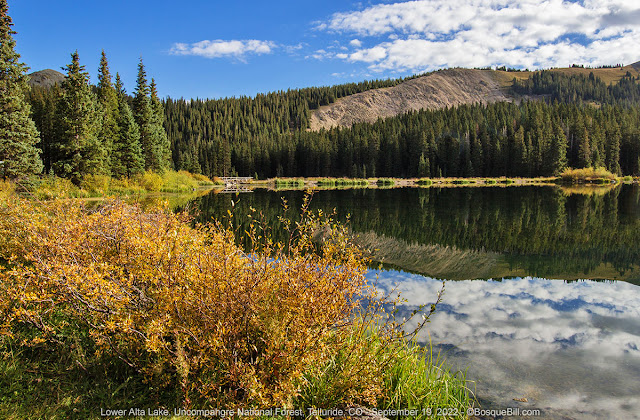
|
|
A view of the lower lake looking toward the dam
|
I was in no rush to pack up, even though I was leaving today. Yesterday I'd
requested a weather forecast via my inReach satellite communicator, and it
indicated that rain was going to move into the mountains, maybe tonight, but
certainly by tomorrow. I thought I'd move to one of the sites I'd planned as
an alternate for the trip. Either up on the ridge between the two forks of
the Dolores River, or down in the valley of the west fork.
On the drive down I noticed a spur road I had neither seen last time nor on
my drive up this time. The acute angle of the junction is such that it is
difficult to see while driving up the road. It looked like it was open and
not marked private. In looking at Google Maps satellite view at home I can
see a pond labelled Wild Boy Lake. There is evidence of vehicle wear and
likely dispersed camping. In searching if there was camping allowed there I
came across this
NFS Alta Lakes Recreation Area Master Plan
document.
Published in December 2018, some of the suggested changes have been
implemented, such as the Phase I modifications to Lower Alta Lakes camping
area, but I'm unsure about the progress of the other changes. I suspect many
will not see implementation any time soon. It does imply that dispersed
camping is available around Wild Boy Lake. It may be restricted in future,
though not eliminated.
It also confirmed my observation of last year that there are a few dispersed
camping spots in Gold King Basin. Those are accessible via a side road that takes off
Alta Lakes Road less that a thousand feet before the entrance to the
campground. My impression from the Master Plan is that they may formalize
the campsites in Gold King Basin at some point. If you are interested in
visiting the area the document is informative.
Dunton Road
I turned south on CO-145, then took the switchbacks up Dunton Road, about 5
miles south of Lizard Head Pass. I turned south on Eagle Creek Road that
runs along the top of the ridge. I checked the dispersed campsites along
there, most were taken by hunting camps, though one was open. I thought I'd
check the sites lower, closer to the river, before making a decision on
where to camp.
I stopped at the Calico Trailhead parking area to use the vault toilet. I
also flew my M2P up a few hundred feet to take photos and a panorama. What
with the clouds the lighting was not good for photos. The panorama is mildly
interesting and does give a good sense of the geography. That's Mount Wilson
and you can just see Lizard Head to the right.
I returned to Dunton Road and continued west. I paused to briefly chat with
a couple hunters camped right by the road. It is elk season, but they were
unsuccessful so far.

|
|
Mount Wilson north of Dunton Road
|
The short stretch of road between the Navajo Lake trailhead and the bridge
across the West Dolores River is where I'd seen potential campsites during
previous trips along the road. One site was definitely taken by hunters. The
other good location had a car parked there, but no evidence of tents or
camping gear.
I continued down to the the NFS Burro Bridge Campground. It is a clean,
pleasant developed campground well above the river (no river access). Vault
toilets and water are available. There are many corrals, as well. I saw
three trucks with large camping trailers pull out as I pulled in. No one
else was in the campground. Fee is $22 (half off with annual or senior
pass.)
I decided instead to drive back up to look at the site where there had been
a car parked. Luckily enough it was now gone. I drove off the road and up
onto the meadow. I saw double-tracks that led farther up and around a corner
where I discovered a very nice little site amidst the aspens. It looked like
it would work out best if I backed in and stopped where I'd get some late
afternoon sun on my solar panels, so I turned around and did exactly
that.

|
|
A pleasant afternoon in my campsite off Dunton Road.
|
I was now at around 9000' and the temperatures were in the mid 70s. I sat my
chair under the trees and enjoyed the scenery while reading my book. The
view was not spectacular like at Alta Lakes, but very verdant and easy on
the eyes. Later I walked around and explored a bit. I was close enough to
hear the road, but far enough back not to be able to see it. Very few
vehicles drove by.
Tuesday, September 20th
I fully expected to wake up to clouds or even rain, but was greeted to clear
blue sky and sun. After breakfast I packed up and headed south, down Dunton
Road, stopping once or twice for photos. I quickly realized that the slopes
of this entire upper valley were carpeted with aspen and made a note to
myself to return here for a future autumn foliage trip. Nearly all the aspen
were thick with green leaves, but a few gave a hint they were at least
thinking of changing sometime soon.
There is another dispersed camping area off Dunton Road next to the river,
just before you get to the Cold Creek Road junction north of Dunton. I
hadn't checked it yesterday as I fully expected it to be full of hunters,
but no one was there when I drove by.

|
|
Dunton Road - you can just see the road to the camping area described
above
|
By the time I reached the lower valley and the pavement, high clouds were
moving in. When I climbed out of Dolores and looked to the west I could see
rain moving in. I was doing well to get out of the mountains when I did.
The rest of the trip was thankfully uneventful as I returned home via the
same route as I had driven out on. I was most of the way home when a
thunderstorm gave me a free car wash. And of course it was hot and dry once
I pulled in my driveway.
Thanks for reading my blog and as a public service I'd like to remind
everyone not to believe every datum you see in every map. Sometimes the
map makers introduce "errors" to catch copyright thieves, sometimes they
get it wrong, and probably more often the road has been closed or the
campground has moved. Always check a local source if your route or
destination is critical.


Bill, a great trip report, and superb photography! Thanks, I needed a pick-me-up today.
ReplyDeleteHad to read this again! I so enjoy your trip reports!
ReplyDelete