Continued from Part 2. To begin this post, jump to Part 1.
Saturday, September 25th (continued)
Telluride, Placerville, Ridgway
The landscape was beautiful as I drove north back on the highway toward Telluride. I should have stopped the photograph the mountainsides around the town, but there wasn't a safe place with a view to pull off with the truck traffic. I bypassed Telluride and headed down the San Miguel River valley. Just past Placerville I turned northeast on CO-62 toward Ridgway.
Though there were few aspen along this highway, the oaks and other vegetation were showing their autumn colors. I stopped at the scenic overlook to photograph the foothills of range of mountains north of Telluride and west of Ouray, Mount Sneffels Wilderness. The light was very poor, with the camera pointing into the sun, but I did the best I could and took a 3 image panorama, but the left-most exposure was almost directly into the sun, so I only processed two of the shots.

|
| At the scenic overlook west of Ridgway. Click to see a larger version. |
Ouray and South on the "Million Dollar Highway"
Fall had not yet come to the village of Ouray. As the highway climbed up and south very few trees showed color. It wasn't until the switchbacks about 5 miles south of town that the aspen began to change, and dramatically, too! Once up on Ironton Park the color was brilliant.

|
| A grove on the west side of the highway at the south end of the park |
I was dazzled by the bright yellows and oranges, especially as I had not expected them this early in the season. There were large groves that had not begun to change, but it was still fantastic.

|
| Hayden Trail |
From here, until the highway climbed above the aspen zone at Red Mountain Pass, the color was amazing and the photographers were out in force! I stopped a couple of times, including at Crystal Lake at the Hayden Trailhead to take photos.

|
| Looking north across Crystal Lake at Red Mountain |

|
| The southwest corner of Crystal Lake |
I also sent the drone up for a spherical panorama and stills.

|
| An aerial look south. US-550 pointed toward Red Mountain Pass. Crystal Lake on the right. |
I strongly recommend clicking the full-screen icon in the upper right corner!
I stopped at the Red Mountain Mining District scenic overlook hoping I could point my camera back down the valley with the sun at my back. The overlook is very overgrown these days and most of the view is of the trees right in front of your face. I walked around gave it a try best I could.

|
| I managed to find a small window of a view from the overlook. |

|
| This is one of the old mining buildings adjacent to the overlook. |
Silverton and Environs
I didn't turn off on South Mineral Road this time. I'd read where the campground and much of the road had been closed due to the 2020 Ice Fire. As I'm writing this post I have now found the area had been partially opened beginning September 15, 2021. Usage of the area has grown so much the last 5 or 10 years that it is very difficult to find camping spots and the traffic on the road kicks up lots of dust. Perhaps I should have tried it; perhaps the crowds would have thought it still closed as I had. Oh, well, my recollection is the aspen up the road generally were a week or two behind the rest of the region anyway.
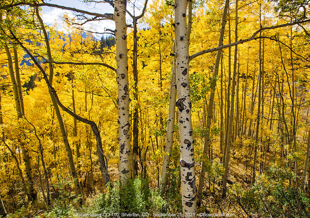
I drove through Silverton. It was slow going with all the vehicles (maybe South Mineral would have been crowded, after all.) I turned up the road toward the ski lift and the Gladstone mine site. There were fantastic views of the town of Silverton amidst the aspen.

|
| Silverton as seen from CO-110 just north of town. |
I had hoped to find a dispersed campsite up the road, but it was surprisingly wide and very, very dusty. Maybe I should have remembered about the Gold King Mine spillage of 2015 and that the EPA had established a remediation facility at Gladstone. The only campsite I found featured a prominent view of that facility and was, therefore, less than desirable.

|
| About the only thing left of Gladstone mine. I believe this is the mill foundation. |

|
| On the way back to Silverton, this great perspective of Kendall Peak |

|
| I'm often dazzled by the sun shining through the aspen, but usually disappointed by the resulting photograph - this time turned out better than most attempts. |
I drove up one of the steep, rocky alpine roads for a ways until I realized it would likely never lead to a suitable campsite. Only thing to do was turn around. I thought I'd check out the forest road that goes south from Silverton, FS-33, as it had possibilities looking at the map. When I got there, however, it seemed to be way too popular with trail bikes and ATVs, plus it seemed to cling to the side of the mountain and was not likely to have campsites.

|
| A view of Silverton and surrounding hills from near the Animas River. |
If anyone knows of good places for dispersed camping in the Silverton area I'd appreciate hearing from you. Thanks.
My Plan B was to proceed on down US-550 toward Durango while the light was still good for autumn color (though heavy clouds were moving in) and drive on into New Mexico and camp at Angel Peak Scenic Area south of Bloomfield. If the BLM primitive campground was full, there were a number of picnic areas along the road where camping was allowed.
Highway to Durango
The views from the highway were wonderful. I stopped a number of times to take photos.

|
| The increasingly heavy clouds were becoming a problem for photography. However, in looking at this shot after the fact, I thought the dark cloud shadow was quite striking. |

|
|
Kendall Peak from near Molas Pass. I think the road I see across the way is the aforementioned FS-33 from Silverton - looks steep! |
As I was driving south I came around and down a horseshoe curve and saw a lone photographer with her tripod precariously set up between the highway and a steep drop-off. The view she'd found was amazing, so I stopped as soon as was safe. I ran across to her and asked if I could poach her perspective. She acquiesced and offered to move her tripod. I replied "No, thanks. That's not necessary." ( For the web, handheld photos are perfectly fine.) I was able to return her favor - she asked if I knew the time for sunset, as her phone had died. I was able to look this up for her. This may be my favorite image from the day.

|
| West Needle Mountain from along US-550 |

|
| I stopped a little farther down the highway to get a closer shot of just this grove. |
The hillsides around Durango were bronze with oaks. It was quite pretty, but it didn't present a photo opportunity.
New Mexico
When I crossed the state line someone turned the wind velocity knob all the way up. There were also a number of rain storms off across the landscape. I guess the storms the forecast had predicted had hit. I started having second (and third) thoughts about my plan to camp at Angel Peak. It's right on the edge of a drop-off and exposed to the weather. Somehow lying in bed, trying to sleep with the wind rattling the soft sides of the pop-up and the whole camper rocking in the gusts, didn't sound particularly enticing. It was, after all, only a few more hours drive to get home.
Time to implement Plan C - C as in Cuba, NM. I'd stop at my favorite restaurant in Cuba, El Bruno's, and order one of their delicious green chile cheeseburgers. I'd sit in my truck while it was being prepared and do my evening meditation to recharge body and soul. I would eat dinner in the parking lot, then drive the rest of the way home. This worked out very well. As expected the burger was so big I was only able to eat half (but the second half was almost as good the next day.)
I drove through stretches of highway that had been rained on, but they were not slick and I didn't experience any rain directly. It was well past dark by the time I got home. I unloaded only the essentials and collapsed thankfully into my bed.
What an enjoyable trip with the beautiful surprise of autumn color! Glad you could come along via my blog.


