
May 1 - 6, 2019
Remember to click on any photo for a larger version.
Part 1 of 3
On my last trip of the season last year I drove up Lower Butler Wash Road all the way to highway UT-95. That was my first time up that road and I saw many areas that looked interesting enough to explore in future trips. Over the winter I did some research on-line and with friends to identify the first spots I wanted to check out - the Wolfman Petroglyphs and the Monarch Cave ruins. This is where I would start for 2019 and add on such favorites as Valley of the Gods, Cedar Mesa, and maybe explore a new area.
Wednesday, May 1st
After some delays I was able to get the travel/camping season started on May Day. I drove up toward the Four Corners after stopping for lunch at El Bruno's in Cuba. US-64 between Bloomfield and Shiprock is a dreadful stretch, lots of traffic, and cheap commercial development. I'd previously found a county road that bypassed Bloomfield itself, but this day there was an added "bonus" of road construction between there and Farmington. Filled my gas tank at Beclabito, NM and drove up US-191 across the San Juan River. A left on US-163 and at just less than a mile, a right on Lower Butler Wash Road, Co-262.
Wolfman Petroglyphs
The turn-off to the trailhead leading to the Wolfman Petroglyphs is one mile north of the highway on Lower Butler Wash Road. Turn west just before the fence and the parking area is 500' farther. It's about a quarter mile to the petroglyphs down the dirt trail, across the slickrock, then toward the south, down into the wash.
 |
| The trail crosses this slickrock. Follow the cairns southwest. |
 |
| The pinch point is between the boulder and the rock face. The trail in the wash leads to the ruins. |
Hiking sites rate the trail as easy, but it's quite a bit more challenging if you are mobility limited and/or dislike drop-offs. I was able to squeeze through the pinch point without issue, but immediately after is a rock to scramble down to the ledge that leads down into the wash. My knees said "No Way! Look at that drop off if you stumble", so I slid down on my behind (note to self: in future remove wallet from back pocket before sliding down a rock (at least I got a chance later to use the needle and thread I've had in my camper for years.))
 |
| Slide down that red sandstone, then walk down the ramp. |
It's also a bit tricky once you get to the cliff face where the rock art is to be found. I suggest moving down once you encounter the chain BLM has installed and viewing from below.
NOTE: The panel has been damaged with bullet holes, as have many petroglyphs in Utah. In the two detail photos that follow, I chose to remove those holes in post-processing so you (and I) can enjoy their beauty without our blood pressure spiking because there are people with so little respect or appreciation of this art that they would intentionally vandalize it.
 |
| Left (north) panel. The smaller of the two. |
 |
| Main, Wolfman panel. |
 |
| Complete Wolfman Petroglyph panel. |
 |
| Looking up the wash. You can see the ramp up the cliff face middle right. |
 |
| The ramp up. You can get a better perspective of the slope in this photo. |
There are small ruins up the wash. I didn't visit as I was told the terrain might be a bit tough for me to handle, and the adobe ruins are very small. Turns out you can seem them easily from the rim of the canyon north of where the trail drops down.
 |
| The ruins above the Wolfman Petroglyphs as seen from the slickrock along the edge of the wash. |
 |
| Looking north up Butler Wash from near where the photo above was taken. |
 |
| There was still snow on the Abajo Mountains. |
Butler Wash
 |
| Driving north along Lower Butler Wash Road |
I drove on up the road to look for a campsite. Just by coincidence I turned down the same side road looking for a site among the cottonwoods as I had last fall. This time there was a Tacoma with a simple shell in the site I'd used last year, but the road T's and the other direction was a very nice site at the end. There were enough trees and vegetation that each site was fairly private.
 |
| My campsite. |
I did walk over and introduce myself to my neighbor. The young man was a professional musician from Wyoming and very congenial. I also asked to make sure he would be OK with my flying my Mavic 2 to acquire some aerial photos. He thanked me for asking and said it would be "all good."
 |
| Aerial view of my campsite with Comb Ridge to the west. |
 |
| Looking north along Lower Butler Wash Road. |
 |
| Looking south along the road. |
Thursday, May 2nd
I took a few photos from around my campsite before packing up and heading north the next morning.
 |
| View of Comb Ridge and my campsite from across the road. |
 |
| I scrambled up the small cliff across the road to get this southern view with boulders in the foreground. |
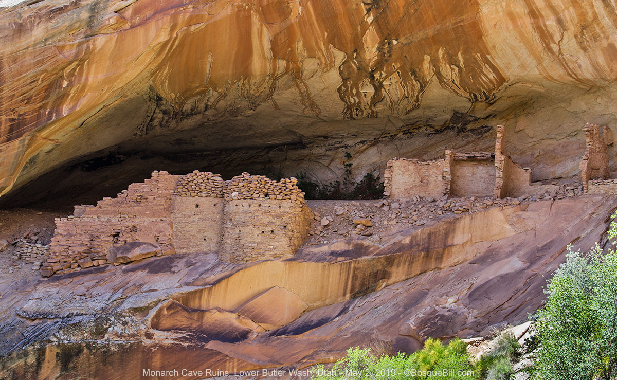
Monarch Cave ruins
My destination was the cliff dwellings in Monarch Cave. There are no directional signs along Lower or upper Butler Wash Road to inform you where any of the trailheads can be found, so it pays to do your homework. Using Google Maps I had found and entered the coordinates for the trailhead into my Garmin Navigator app, so was able to easily find the parking area. It would have been tricky otherwise as there are many side roads leading toward the wash and ridge in the area. An online search also turned up a few hiking websites with directions on finding and following the trail, its length (1 mile each way), and rating (easy), along with some photos.
There was a post marking the trailhead. The trail dipped down into and across the wash before following the canyon west. Other than the first small slickrock section, the trail mostly stayed in the canyon bottom until approaching the end. Here is a sequence of photos illustrating the trail.
 |
| Parking area and trailhead. |
 |
| The trail quickly cuts down into the wash. |
 |
| After crossing through the cottonwoods in the wash, and walking over a short section of slickrock, you continue up the bottom of the canyon. |
 |
| The end of the canyon is in sight. The ruins are at the end, beyond those trees. |
You climb out of the canyon onto a wide terrace which narrows to a ledge leading to the ruins. There are great views of the dwellings, as well as back down the canyon. If you are agile (and fearless) you could work your way along the steeply sloped slickrock and walk among the ruins. I chose not to do that, but had brought along a camera lens that allowed a closer view.
 |
| First view of the ruins. The area with the metates and pictographs is on the right. |
 |
| Closer view of the ruins thanks to a 70mm lens. |
 |
| Here you can see the steep slickrock you'd have to traverse if you wanted to walk among the ruins. |
Along the ledge that is easily accessible are places where the inhabitants ground corn, and holes in the cliff that likely helped anchor wood structures for this living space. There are hand prints and other figures painted on the cliff walls, as well.
 |
| Examples of the pictographs found along the the walls of the smaller cave. |
 |
| Trough and Basin Matates. |
I met a number of interesting folks at the ruins and along the trail. They told me about the Processional Petroglyph Panel that is located about a half-mile, or so, south of where we were. They all said it was amazing. Another time.
 |
| This is the view the inhabitants saw, looking down their canyon. |
 |
| Many of the cacti were beginning to bloom. |
The journey continues in Part 2
FOR SOME REASON GOOGLE/BLOGGER IS NOT LETTING ME REPLY TO YOUR COMMENTS ON MY BLOG. Hopefully this will be fixed sometime, but meanwhile, thanks I appreciate you taking the time to comment. If you have specific questions, email me at the address above. - Bill
Another swell multi-day excursion to country most of us will never see. Your drone photography adds a very special perspective, and makes me wonder if the Navajos allow drones in the Canyon de Chelly. Some of your shots resemble that area.
ReplyDeleteThanks, Bill...
Thank you Bill a great trip story.
ReplyDeleteBoy the southwest sure is pretty.
The desert varnish is really dark in some spots.
Really enjoyed your trip.
Frank
Hey, Bill. I'm the guy from Wyoming. Thanks for coming to say hello. Enjoying your photos! Thanks.
ReplyDelete