
September 17 through September 23, 2017
The last couple of times that I drove north into Colorado to view the autumn foliage I was was a little late and missed "peak" color. This year I thought to go a bit earlier and the weather forecast looked good for most of the week (there was a possibility of rain toward the end of the week.) This trip would be a combination of new and previously traveled areas.
Spoilers: There were beautiful areas of yellow aspen, but for most areas I was well ahead of peak color.
Part 1 of 4
Sunday, September 17
I drove north from Albuquerque, taking the Santa Fe relief route. I stopped briefly in Espanola for a burrito and gas (no irony intended). It began to cloud up and rain as I headed up US-85, to my surprise. It was off and on all the way to Chama where I turned north on Highway 17.
As I drove over Combres Pass and started down the other side I noticed large areas of dead trees that I didn't remember seeing a few years ago. Had the spruce bark beetle since struck the area? Light rain continued to fall and the wide vistas usually seen along the route were mostly obscured by mist and clouds.
 |
| View of Conejos River Valley from Highway 17. Rain in the distance. |
I intended to explore up the Conejos River valley toward Platoro, then continue on through to US-160 north of Wolf Pass. This would all be new territory for me. I'd driven a few miles up this way a few years ago on a recommendation from some folks camping along Rio de los Pinos. The washboard was so severe on the road, and my time was limited, that I turned around after only a couple of miles thinking I'd return later - this was that later.
Conejos River
I turned off 17 onto the forest road, FR-250, and lowered the air pressure in my tires to mitigate some of the washboard affects. My left turn signal exhibited an abnormal rhythm when I turned and I verified that my front turn light (which is also the daylight driving lamp) was burned out.
There was a large NFS information sign which seemed to indicate all of the established forest campgrounds up the valley were closed. I was a bit surprised to see this in September, but not too concerned as I'd intended to disperse camp in any case. However, when I then saw the notice that the area behind this sign was a Restricted Camping Area (only camping in official campgrounds and designated areas) I became a little more concerned that the closures might affect me.
The light rain and low clouds continued to obscure much of the scenery. I would get a misty glimpse from time to time, enough to conclude I was probably driving though a beautiful valley. I was also very glad I had aired down. The road had areas of rough washboard, then sections of bumpy rock, then smoother areas with deep pot holes.
I passed a number of pull-outs intended as parking areas for river fishing access, but there were not many folks fishing in the wet weather. I also passed a couple closed campgrounds and a commercial lodge. I then drove though the Pinnacles area, and tried a photo.
 |
| Pinnacles during a break in the clouds. This is also an example of "blown highs" as the sun behind the clouds was too bright for the sensor as the camera was trying to properly expose the cliff face. |
The Lower South Fork Trailhead parking area was full of vehicles, including many large capacity horse trailers. Not too much further up the road was a gravel road toward the river marked as the trailhead tent camping area. I had seen this area on the satellite map view when I was planning my trip. I turned off to check it out as a possible camping site. The camping area was primarily a loop of gravel road and a vault toilet. This was on a bluff well above and away from the river. I guess you're supposed to park along the loop and carry your tent onto the adjacent meadow. It looked exposed and uninviting to me. There was a short road beyond the loop - don't know if it was sanctioned - which lead downhill to a small camping spot surrounded by trees. There was already someone there with a pop-up tent trailer and the trees were dripping in the rain. I turned around, drove back up to the main road, and continued up the valley.
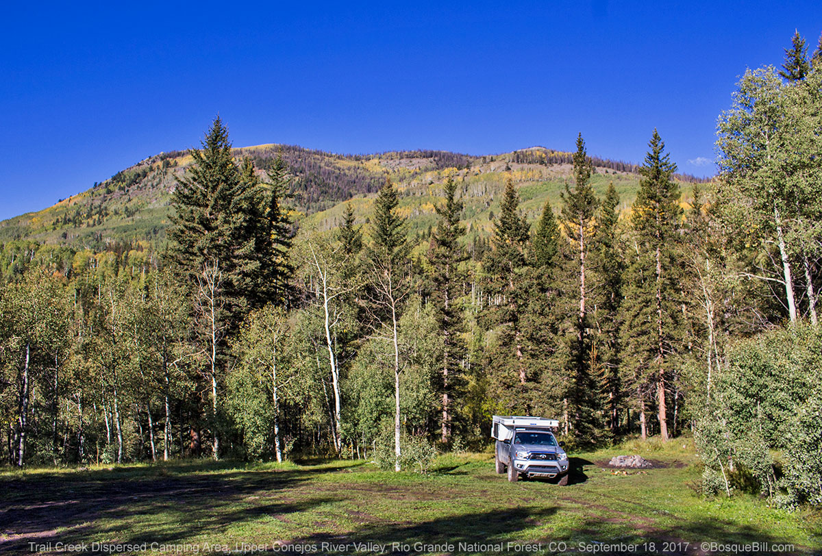
Trail Creek Dispersed Camping area
About 3 miles farther along the road I came to the officially-marked Trail Creek Dispersed Camping area. The road into the area is not well maintained, but not too bad - not requiring a high-clearance vehicle exactly, but not suitable for a low slung car, either. The road wanders through a couple large meadows and splits a time or two. There was a travel trailer near the main road and a hunters camp, with horses, on the margin of a large meadow, but no one else. There were large puddles in the road, but the bottoms were firm.
I drove down a moderately steep section that lead to the very end of the road. It was a pretty spot, but a little mushy. I found where I could place my camper that would be level enough, avoid most of the mud (though I had to put a few pieces of firewood under one rear tire), and still leave the loop open for folks to turn around if they drove down. I was able to set up the camper during a short hiatus in the rain.
 |
| My campsite during a break in the rain. |
There was a trail leading steeply down to the river, but my knee wasn't feeling good enough for me to attempt that, even had the weather been favorable. After a while, a couple fishermen parked in loop and walked down to try their luck. I asked upon their return, but they didn't catch anything.
 |
| I walked back up the road from the campsite to a bluff where I could see the river. |
When the rain let up again, I walked back up the road a bit and took a few photos. Then more rain and I crossed my fingers that it would clear up tomorrow.
 |
| There were three little juncos who hung out at my campsite hunting for seeds in the grass. |
Monday, September 18
 |
| Wet campsite under clear sky |
It was a very chilly 30 degrees in the morning. Everything was wet and soggy, but the sky was clear. My plan was to pack up, then backtrack maybe 4 or 5 miles to take photos of scenery I'd missed in the rain yesterday.
 |
| View of part of the dispersed camping area as seen from the road. |
 |
| Tent camping area. |
When I drove back down the road I discovered the tent site had the most amazing, breathtaking view. I almost wished I'd camped there so I could wake up to the astounding sight of the surrounding mountains in the clear air and blue sky. I was happy to see a VW bus with a pop-top camped along the parking area. It was similar to the one I owned back in the 70s.
The sun was exactly in the wrong place to get good photos of the Pinnacles, so I was able to only attempt to capture the northern end.
 |
| Pinnacles - the sky was blue, but the sun in the wrong direction. |
 |
| Heading back north again. |
After taking a few pics, I turned around and resumed my trek up the Conejos River. There were more folks fishing this morning with the nicer weather.
 |
| Conejos River |
 |
| Conejos River farther up the road. |
 |
| Conejos River below Platoro |
 |
| Conejos River road below Platoro. |
Platoro Area
I drove past the summer-home/vacation community of Platoro. It was originally a mining community, but faded in the early 20th century. I turned off on the road to the Mix Lake Campground, thinking that was the road to the reservoir. The campground was closed and the road a dead end. I drove back to the main road and continued up some switchbacks before coming to FR-247, the access to the reservoir.
 |
| Mix Lake |
There is a natural looking lake, Mix Lake, just before you get to Platoro Reservoir. There was an older couple fishing there when I stopped to look it over. They were not catching any fish, but it was less windy here than on the reservoir. I commented that it was a pretty spot, but the lady lamented all the dead trees - looked like the spruce bug had hit hard. She said she and here husband were here just over a year ago and all the trees were healthy.
 |
| Mix Lake looking north. |
I continued along the road above the reservoir, FR-247. There was a sign informing this area was not in the restricted camping zone. There were a few campsites perched above the lake, but they were just open areas filled with hunters or fishers. The water was low and most of the upper reservoir area was mud flats. The lake was not picturesque, so I haven't included any photos other than the one below. The road ended at a wilderness trailhead, though there was another forest road that climbed west up the mountain a few miles before that which I didn't explore.
 |
| Aspen along the road. Just a glimpse of Platoro Reservoir on the left. |
Stunner
 |
| Stunner Pass |
 |
| Lookout Mountain, Little Red Mountain, and Big Red Mountain. |
 |
| Placard along Stunner Pass Road. |
I returned to FR-250 and continued, crossing through Stunner Pass to the junction with FR-380, which I took. 250 turns east and follows the Alamosa River toward the old mining town of Jasper. There was a dispersed campsite (or perhaps two, I didn't really investigate) next to the bridge across the river.
 |
| Alamos River. Looking back toward Stunner Pass. |
I was surprised to find that the Stunner Campground was open, as I thought the sign I'd seen the day before said they were all closed. Likely I didn't notice that Stunner was not referenced on the sign. I stopped briefly and talked to an older couple from South Fork who drive up to view the aspen and have a "wienie roast" every year. I asked if there was an auto parts store in South Fork, explaining my burned out turn signal lamp. They said "no" the nearest was in Del Norte, but I should check Rainbow Grocery as they might carry one.
Continuing on 380, there were a few areas that might afford dispersed camping, but not all that much. I passed the turn off to Elwood Pass. It is possible to take that 4WD only trail over the pass and down into the East Fork of the San Juan River area. The ranger I spoke with in Glendwood Springs before my trip said the road was open, but rough and slow-going, so I skipped it.
Summitville
I continued west, then north, on FR-380. I decided to take a short detour up FR-330 to the old mining town of Summitville (and current Superfund toxic waste clean-up site.)
As I made the turn I stopped to check a rattle and discovered to my shock that my side window/emergency exit was undone; the tilt of truck as I was stopped had the bottom edge a couple inches open. OMG! How did this happen? It is held closed by two strong latches, yet both were somehow open. I crawled inside and it wasn't easy to reclose those latches. I have the rollover-couch camper layout and store lots of stuff between the back of the couch and the wall/window. Luckily I'd placed a piece of stiff closed-cell foam (part of a cheap sleeping mat) against the wall/window as insulation. That was the only thing that kept my gear from being scattered along the road for who-knows how many miles. I could have lost my pillow, a sleeping bag, portable table, tray, survival kit, hats, gloves, parka, and more. Once I got the latches closed, I put gaffer tape over them to keep them closed, though I still have no clue as to what could have popped them in the first place. I will periodically check in future that both are latched, and if you have a camper I suggest you do the same. I've had the camper for 4 years, driven over lots of much rougher roads than on this trip, and this is the first time the latches have come open.
 |
| Approaching Summitville. That hill in the middle of the photo is comprised of mine tailings. |
 |
| Summitville with the Superfund site in the background. |
 |
| Summitville. |
 |
| Superfund site; legacy of the Summitville mine. |
The Superfund structures dominate the site. The remaining buildings were not all that interesting. If one were to continue on 330 you'd come to the Del Norte Ranger District - I may have to explore that area on a future trip
I returned to FR-380 and continued northwest. There were a number of dispersed campsites along the way, though nearly all were full of hunter camps (large tents, ATVs, trailers, etc.) The road follows Park Creek and the scenery is very nice. There are a number of 4WD trails branching off, which may explain its popularity with hunters, and a couple forest roads. As I got closer to US-160 there were a few small, dispersed campsites near the creek that would be quite nice, and were open, though I intended to travel farther this day. In retrospect I'm not sure why I didn't take any photos along this stretch - it was pretty, but I guess there were no big vistas that made me want to stop for pictures.
Just before the junction with US-160 I aired-up to highway pressure.
South Fork
I turned toward South Fork on the highway. I filled the gas tank in town and checked the attached c-store for my burned out bulb. They had a few, but the clerk suggested I check "upstairs" at the nearby grocery store. Rainbow Grocery looks like a single-story building from the outside, but just in the main entrance is a staircase to a low-ceilinged upper floor. The floor is jam packed with all sorts of things you'd expect in a general store - hardware supplies, items for kitchen and cooking, camping & fishing supplies, and much more. They also refill propane bottles. I found the automotive bulbs and then found a match for the one I needed - two for $6.99. I replaced the bulb there in the parking lot and was relieved to have working turn signals and driving lights again.I headed northwest on CO-149, "Silver Thread Scenic and Historic Byway." It's one of my favorite highways in southern Colorado - it runs along the Rio Grande (and an historic narrow-gauge railway) for much of its length; through a beautiful canyon with palisade cliffs; squeezing through the narrow Wagon Wheel Gap into a verdant open valley; it touches the southern tip of the old mining town of Creede. I didn't take photos along this stretch as I felt there are many from previous journeys.
Middle Creeks
In my pre-trip planning, I had identified an area southwest of Creede I wanted to explore for camping and hopefully autumn color. I turned off the highway onto Middle Creek Road, FR-523, just before the second crossing of the Rio Grande. This road takes one past a residential area before following Middle Creek. On a whim, as I didn't really have a specific destination, I took the left fork onto FR-528. After crossing some grasslands it turns into foothills. There's a junction for Spar City up a canyon, but that's a private road.
 |
| Middle Creeks area |
At the next junction I took the lower road following a sign for the Ivy Creek Campground. I later figured out this is FR-526. I passed another side road, but keep following the signs to the campground. I was primarily looking for dispersed camping, but wanted to check it out.
The road toward Ivy Creek essentially follows Mountain Creek along the edge of a wide valley surrounded by peaks that comprise the Continental Divide. There was a cool dispersed campsite by the road above the creek, but it was totally exposed to the increasingly gusty winds so I continued up the road.
 |
| Looking back north from the road. |
I turned off on the side road for the Ivy Creek Trailhead and campground. The tiny campground would be suitable for one or two cars with tent campers, there was no level spot for even a small pop-up camper such as mine. It was even a bit of a challenge to turn around. I returned to the road. Only about a hundred feet farther the road crossed a small bridge across Mountain Creek. There was a nice little campsite on the far side with lots of green grass and even a picnic table, however there was also a small herd of cattle with their eyes on that grass.
I continued up the road, but it effectively ended at a closed gate for the Mountain Creek Ranch. I turned around, drove down the road and tried the first road uphill, FR-527. Tall trees lined the road and there were no opportunities for camping, though I did pass a side road. I gave up after a mile or so, turned around and tried the little side road. It was even worse, so I drove back down to 526.
Lime Creek Road
I took the next junction which turned out to actually be the continuation of FR-528, following Lime Creek up the valley. It ran across a steep, wooded slope along private land below. After a couple miles the road descended into a narrow valley with the stream crossings. I noticed there were a couple places to pull over which would afford space to camp if all else failed, though I'd be right next to the road. Watching the map I could see switchbacks ahead that would climb steeply. I found a nice place to pull about 20 feet off the road opposite the stream before the switchbacks. I was able to get fairly level and set up camp.
 |
| My campsite just off Lime Creek Road. |
This turned out to be a nice enough spot and there was little wind and no sign of cattle. It was quiet; only one vehicle passed the entire evening.
Tuesday, September 18
It was 23 degrees when I got up in the morning. I looked over my maps and tried to lay out my plans for the day. Once it warmed up a bit and the sun came out from behind the mountain. I walked around and took a few photos.
 |
| My campsite in the morning light. |
 |
| Lime Creek runs down the valley to the left. |
I drove back down the mountain and took the right that would lead back to the highway. The previous afternoon I'd spotted a double track that headed steeply up a hill on the west side of the road. The top looked very exposed to wind so didn't check it out then for camping. I tried it now to see if there was a view up there. Wow! A glorious vista opened up before me. I could see nearly 360º around. There were tall peaks forming the Continental Divide on one side, the Rio Grande, Hogback Hill, Bristol Head, and the mountains west of Creede on the other side. I took a bunch of photos, including a phone panorama, but the view was just too vast to capture. I've included the best of one wide-angle lens exposure here.
 |
| View from the hill |
From here I knew I wanted to explore a couple forest roads I'd driven by many times as I sped by on the highway - South Spring Creek Road and North Spring Creek Road. I'd look for future campsites and check out the scenery. This was about as far as my pre-trip planning had taken me. That morning I'd seen FR-788 on the Gunnison Basin Public Lands map; it ran from near Slumgullion Pass northeast and connected back to CO-149 farther north. I called District Ranger Office in Gunnison, once I was back in cell phone range, to check if the road was OK. The person I talked to was not familiar with the road, but assured me there were no reports of problems for its length.
Continued in Part 2
Fresh air for the eyes, especially during the nasty winter of 2017.
ReplyDeleteThanks!
Thanks, Chris!
Delete