Continued from Part 2 -
Starts with Part 1
Colorado
Part 3 of 3
Remember, click on any photo to open larger versions of all images.
Friday, August 25th, continued
At Dinosaur, CO, I turned off Brontosaurus Blvd (US-40) onto Stegosaurus Fwy (CO-64) which passes through some oil/gas fields near the town of Rangely, where I turned south on CO-139.
This road runs though a few miles of dry, washboard hills which I later discovered is part of the Canyon Pintado National Historic District. Apparently there are hundreds of archaeological sites, pictographs and petroglyphs, but I was not able to find very much detailed information about the area online. I had noticed cars parked at a few trailheads while driving through. The highway ascends the 8300' Douglas Pass before dropping back down and reaching I-70 near Lorna, CO. Just south of the pass I did notice a dirt road that might have dispersed camping. It would be a cool spot surrounded by dry desert if one needed a stop and it is BLM land.
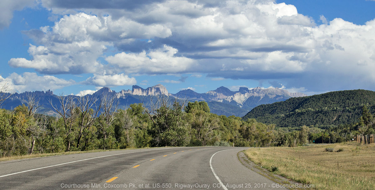
I took the interstate to Grand Junction where I turned south on US-50. I passed Delta with Grand Mesa on my left and the Uncompahgre Plateau on my right - I was back in familiar territory. I'd never noticed Olathe before, but that's where much of the sweet corn we have been getting lately in NM is grown. At Montrose US-550 begins and leads to Ouray, "The Switzerland of the Rockies."
 |
| South of Montrose I could see the mountains near Owl Pass, east of Rigway |
The skies were blue and the atmosphere clear showing off the dramatic mountains. I was so happy to see them again as I'd spent my camping time last year mostly in Utah and northern Arizona.
 |
| Looking toward Ouray as I drove south on US-550 |
 |
| Red Mountain south of Ouray, north of Silverton |
South Mineral Creek
I wanted to visit one of my favorite places even though it seems to have been "discovered" the last few years (and I was coming in on a Friday.) I first camped up South Mineral Creek in 1972 in my VW Campmobile (tm) with a pop top. It, and similar Colorado treasures, had been one of the things that had encouraged me to get my current truck and pop-up camper.
The last time I tried to camp along South Mineral Creek it was so crowded that I abandoned the plan and drove over Ophir Pass instead and camped near Telluride. This time it was pretty crowded, too, though maybe not quite as bad. As I was driving up the road I saw cars pulled to the side and people looking at something with their binoculars. I turned my head to see what held their interest. There were two moose with full racks browsing in the willows on the other side of the creek. I took a few photos, and although the brush hid most of these big mammals, they are nonetheless the best photos I've yet gotten of moose.
 |
| Moose! |
 |
| Just look at that rack! |
Camping along the road is informal, but restricted primarily to designated areas, most of which were very full. I did find what I thought was an isolated spot away from the creek, but after I got all set up and sat down to enjoy the evening, someone's dog nearby began to bark and bark and bark and bark. I just don't understand people who either let their dogs bark incessantly or leave them alone to do so. It was getting late, and the dog had not stopped in 15 minutes, so I had to decide right away: hope the barking stopped or move camp.
I dropped the top, battened down, and left. There two sites that I'd passed up before as they were little more than spaces where the road widened - not bad for tent campers who could walk down to closer to the creek, but no so great for a truck camper. Both of those were now taken, so I returned to the first camping area closest to the highway.
 |
| Lovely evening along South Mineral Creek. Looks nice and peaceful, doesn't it? |
 |
| Evening view of South Mineral Creek. See the crescent moon? |
This is a fairly large area covered with round cobbles; a flood zone in spring I conjecture. There are sections screened by trees and others more like a parking lot. Only one of the "parking lots" had space. I backed between a 5th wheel trailer and a giant Class A mobilehome. At least I was near the creek. It was fairly quiet until the behemoth next door fired up their diesel generator. The noise wasn't too bad, and I was listening to a baseball game on satellite radio, but the darn thing literally made my camper vibrate. Fortunately, they were not bad neighbors and cut it off about 9:15pm. The campground was quiet after that and I could once again fall asleep to the sound of water running over rocks.
Saturday, August 26
 |
| A wider angle photo of my campsite and neighbors, but with gorgeous mountains on all sides. |
Actually, that first camping area on South Mineral Creek is useful. I got there earlier in the day a couple years ago and was able to park in a moderately isolated space right next to the creek. It is also not bad if you come late in the day and want to spend another night or two in the area - simply find an acceptable site the first night, then drive up the road the next morning to find and claim a nicer site.
 |
| The road up South Mineral Creek. |
 |
| More beautiful scenery |
 |
| I caught a reflection in this beaver pond |
 |
| This little Pine Siskin was foraging along the creek |
I knew I was only 5 or 6 hours from home, so chose to spend the morning in this beautiful area. I drove up South Mineral Creek road, stopping a couple of times to walk along the creek and take photos of the striking mountain peaks. I kept an eye out, but saw no moose this morning. There was also a jeep trail I'd been daring myself to try for years. Would I be brave enough to try it this time?
 |
Here's another animated gif for your viewing pleasure.
Let me know in the comments of you love, or hate, these gifs in my blog. |
Clear Lake
I got up the nerve and started up Clear Lake Road. It is not marked as 4-wheel drive only, so I was hopefull it would not be too rough. At the first switchback there were a number of cars parked. I later learned this is a trailhead to Ice and Fuller Lakes. I stopped to chat with a gentleman and his son who were descending the road in their Jeep. I asked about the road condition. He said it was fine, I'd have no problems. I was encouraged.
 |
| View up South Mineral Creek valley from Clear Lake Road |
 |
| A similar view, wider as I'm farther up the road at this point. |
As the road climbed the views were spectacular, especially toward the valley in which South Mineral Creek descends. I could see the road that parallels the creek. I'd driven up that way a few years ago and man, it was so rocky - large rocks that you had to slowly lurch over. The Bandaras Mine ruins are up there and if you ford the creek you come to a wide meadow with space to disperse camp. I didn't camp up there that time as it was cold and at a very high elevation.
 |
| Outflow from Clear Lake forms this cascading waterfall. |
About 3/4ths the way to the lake there is a tall waterfall with space to park at a switchback. I also got a pretty good photo of a marmot there.
 |
| This good sized marmot was following the creek down along, then below the waterfall |
 |
| This Golden-mantled Ground Squirrel ran across the road right in front of me, so I took his picture. |
 |
| It didn't bother him that I was so close as I drove by him, so I snapped this one. |
The road gets a little rougher for that last stretch, but not that bad. I made it to Clear Lake. A beautiful spot at 12000' elevation. The lake is surrounded on three sides by mountain peaks. You could camp there if you didn't mind a parade of visitors all day and the cold temperatures of that elevation at night - still the view is terrific.
 |
| Clear Lake |
 |
| A phone panorama - I had to do a little cloning near the mountain peak, so it might not be totally accurate |
I walked around taking photos and a panorama with my phone. As I was leaving the lake I took photos of the wildflowers. About halfway down I stopped where there was a small site at at switchback, and made a picnic lunch. I drove back out South Mineral Road, past Silverton, and south on 550.
 |
| A field of yellow wildflowers below Clear Lake. |
 |
| The road as it approaches Clear Lake |
 |
| A view of the lake from the same vantage as the previous photo |
 |
| A close-up of the wildflowers - Mule's Ears |
 |
| A last view of the lake from the shoreline |
 |
| A close-up of colorful Fireweed. |
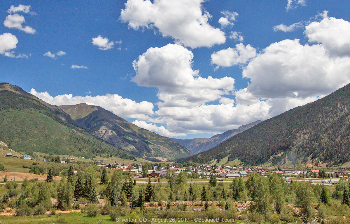
After leaving the South Mineral Creek valley, I passed Silverton.
 |
| Silverton, Colorado |
 |
| This small peak is just to the left (north) of Silverton. Photo taken from the same spot as the shot above. |
I checked out a few side roads for dispersed camping possibilities for a future trip, including the no-fee campground at Little Molas Lake. I relished the views and cool air as I drove down the mountain.
 |
| View from the Molas Pass overlook |
The Highway Home
As I'd already had lunch, I didn't stop at
Zia's Taqueria in Durango, even though they have the most delicious fish tacos.
Soon I was back in New Mexico and followed US-550 home.
It was a great trip, even with the smokey skies. I made it to three states I'd never visited before. I witnessed a total solar eclipse for the first time. Saw an old friend and met new friends. Thanks for coming along via my blog.


You had a fantastic trip,thanks for taking us along.
ReplyDeleteFrank
Thank, Frank, for coming along, and for leaving your comment.
DeleteBill, you covered a lot of territory in only a few days and enjoyed a total solar eclipse! Thanks for letting us come along via your narrative and photos. A very fine trip!
ReplyDeleteSki, I appreciate you stopping by and taking the time to comment - as you always do!!!
DeleteVery enjoyable read. I loved vicariously experiencing the eclipse and the ride through such beautiful country, well depicted in your beautiful pictures.
ReplyDeleteMark, thanks for the comment and for your help with editing.
DeleteI always enjoy your stuff Bill! This was no exception. Great video of the eclipse. Maybe we can shoot 2024 together :)
ReplyDeleteThanks - I appreciate you stopping by and leaving such a nice comment.
DeleteNice again, Bill; sorry we missed it, but the 'other commitments' went well. But then, when a guy from NM tolerates traffic jams to get away from the heat--it just might have been a bit too hot for us northerners. And you sure had to bait me once again for the San Juans mineral belt, didn't you...
ReplyDeleteI have some neat observations from Craters, I'll send them separately. But you wouldn't catch me there in August either, don't blame you for bypassing it.
I was escaping the dust more than the heat, not that that changes your observation much ;-)
ReplyDeleteI just got back from a week in the San Juan Mountains looking for autumn colors. Stay tuned for a blog post.