
June 13, 2013
I departed my camp along South Mineral Creek and headed north on US-550, the Million Dollar Highway. There are theories on the name, but I like to think it is because of the million dollar views from the twisting highway as it works its way up and over Red Mountain Pass. Again no photos as I have both hands on the wheel and there is sheer drop-off at the edge of the pavement with no place to pull off for photos.
My mission was to drive the "Red Mountain Mining Area" trail in the Colorado Backroads guide by Wells and Peterson.
I found the starting point as much by luck as anything. Not the authors' fault, but the junction was poorly marked. I carefully followed their directions, crossing a couple small bridges and drove by the Cora Bell Mine.
 |
| The Cora Bell Mine |
I continued along the windy, narrow road. I honked my horn before going around a couple blind curves as the sight-lines were very restricted. I came around a bend and the famous Yankee Girl Mine and its "often photographed shaft house" was in sight.


From this area I could look west back across the valley and see the Idarado Mine.
 |
| View of the Idarado Mine along US-550. |
The road climbs a few switchbacks and I'm carefully following the guidebook so I don't get on one of the many wrong roads. I then arrive as the Genessee Mine.
 |
| This photo actually taken from a scenic overlook on US-550 using a telephoto lens on my way to Ouray. |
 |
| Another photo from the scenic overlook on US-550 with the Idarado Mine in the foreground. Look just above the left end of the trestle and you can see the Yankee Girl Mine across the valley. |
From the Genessee Mine I got lost. I don't know if the road has changed since they wrote the book or their directions were poor or I didn't follow the directions properly. After a couple of dead-ends I did stumble upon the right route, but the road took a nasty dip and my hitch-receiver mounted steps got whacked.
However, I did find my way to the National Bell Mine - or what little is left of it. I had to ask a couple amateur geologists if that pile of rocks was that mine, which was important as the book uses that mine as a landmark to make a turn. The book also directs you to cross a bridge, which apparently no longer exists, but I did manage to get on the right path and made it to the Longfellow Mine.
 |
| Longfellow Mine |
 |
| Still some equipment surviving at the Longfellow Mine. |
From here you are almost back to US-550 where you turn left, then quickly left again back off the highway to begin the next leg of this trail.
The road along this high ridge, what the book calls the U.S. Basin road, is truly breath-taking. The top of the long ridge is above 12,000 feet in elevation. You can look across the deep valley and see the trails to Ophir Pass and Black Bear Pass (Telluride.)
This road leading up to the high ridge begins innocently enough, through lovely forest and meadows.
 |
| Lower section before the real climbing begins. |
Then the road gets quite steep and narrow. I was fortunate the only truck I met on that stretch was at a switchback with barely room for two. Once it got up high, it widened out a bit... at least in sometimes.
 |
| I stopped here to take photos. |
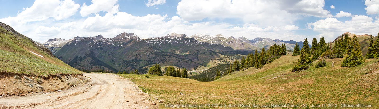 |
| This panorama shows the road and view to the west from the POV of the photo above. Click here for larger version. |
Then more climbing up the narrow road.
 |
| Climbing above the tree line, now. |
 | |
| A 180 degree view from the high ridge - the road is straight at this point, so use your imagination to unbend the five wide-angle images from which this panorama was created. Click here for a larger image. |
 |
| Getting near the top. The view is in a northerly direction toward Red Mountain Pass. |
 |
| Panorama at the crest of the road looking in a southerly direction. Click here for larger version. |
The road dives steeply from here on, though the heavily forested Browns Gulch, and returns to US-550.
I turned north on the highway, retracing my track from earlier in the day. I stopped at a scenic overlook by the Idarado Mine and took the photos you saw earlier in this post.
The scenery coming into Ouray is very dramatic, but I didn't get any photos worth sharing. I need to return to this spectacular area on another trip. By the time I got to Ouray proper, it was hot, at least compared to what I was used to feeling. The town was filled to overflowing with tourists, so I drove on through. It was too hot to even think about camping in the area, so I quickly changed plans. I continued to Ridgeway where I turned west and headed for the Last Dollar Road - the subject of my next post.
Thanks for reading.
Sorry...that is not the Cora Bell...Guston-Robinson Mine
ReplyDeleteJay, you may be right (in which case the mine is mislabeled in my video, as well.) However, I see almost as many references to this site as Cora Bell. Doing a Google image search, there are only a few more returns for Guston Robinson, as Cora Bell, for the same buildings.
ReplyDelete