Sunday, November 10, 2019

Colorado Autumn - October 2019; Part 4

Continued from Part 3. Journey begins in Part 1 - you should start there if you didn't already.

Note: If you click on a photo you can see a larger version - highly recommended.

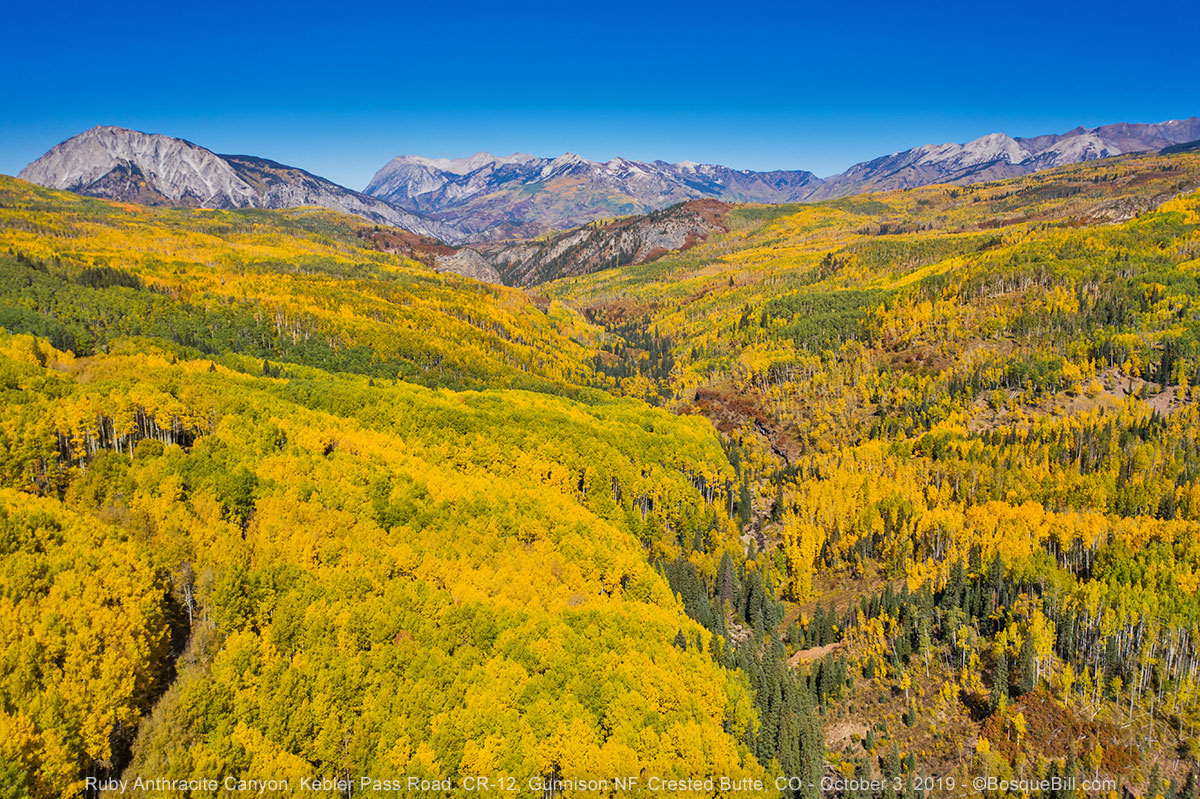
Thursday, October 3 (continued)


Spring Creek Road


At Altmont I turned off CO-135 onto 742 toward Taylor Park. I recalled Spring Creek Road I'd driven a few years ago was very scenic. I could drive as far as the reservoir, then get to Taylor Park from there.

I headed up FS-744 through the narrow valley. However, I saw no aspen anywhere along this route. I expected some along Spring Creek Reservoir, but other than one gone-by patch at the far end, there were none there either. FS-748 over to Taylor Park was no better. (Looking back at my 2017 trip, once home, there were photos of aspen groves along the road and at the reservoir. I guess that's why I expected more this time.)

Spring Creek Reservoir with a few folks fishing and little autumn color.

Taylor Park


Even more disappointing, there were practically no aspen in Taylor Park. Maybe I should have stayed one more day along Kebler Pass Road. Coming down the road into the park, I did spot one good sized grove of aspen northeast of where I'd join Taylor Park Road, FS-742. I turned to find it. Maybe there would be a side road that would get me there.

As I got near I could see the grove was quite a ways off the road. I did find a side road, but it quickly ended long before getting to the grove. Well, I should be able to get photos from up in the air, right? So I launched my M2P. Yes, there they were, though not particularly close. I didn't want to risk flying too far in the wind, so took exposures to stitch together once home.

Panorama of the only patch of aspen I found in Taylor Park

I turned around and headed south. Just past the north end of Taylor Park Reservoir I turned east on Cottonwood Pass Road. FYI, it's FS-209 at this end, but as you go over the pass you enter San Isabel NF and it changes to FS-306.

Cottonwood Pass Road


When I first decided to head toward Taylor Park, I'd really thought I'd find an area with lots of autumn color and camp there. As that didn't happen I'd look for a campsite along Cottonwood Pass Road. I was still expecting rain the next day, so didn't want to turn back west. The one time I'd driven this road it was still dirt, but I remembered a meadow along the way that I was sure would have dispersed campsites around it. I just didn't remember how far up the pass it was and I didn't want to drive too far up in elevation - remembering how cold it had been the night before.

The highway was very nice - smooth and wide. It looked like they followed the old road for the most part. I kept a lookout for side roads that might have campsites. I passed a small road on the left and turned around to check it out. It lead up a rise and over to a small open area where people had camped before. It wasn't a perfect spot, a bit close to the highway, but one of my faults is trying to find the perfect campsite. That quest often wastes time and by the time I find that spot (if I do) it may be too late in the day to really enjoy it. So, I'd camp here. I got set up in plenty of time to sit outside in the warm, low sun for a little while to relax and I didn't miss the first pitch of the baseball game, either.

Campsite just off Cottonwood Pass Road

Friday, Oct 4


Early in the morning I heard light rain on the roof, though only briefly. At dawn, sure enough, it was cloudy as forecast. But it was only partly cloudy, I didn't want to turn tail without reason. I dug out my maps to look for areas to visit on the east side of the mountain range. That way if the weather was bad, I would be headed in the general direction of home; and if it improved I could cut back west on US-160 and either go over Wolf Pass or head up to the area north of Platoro where I'd seen aspen a previous year.

Cottonwood Lake was only a few miles south of Cottonwood Pass Road, so I'd check it out. There was also a paved road headed west from south of Buena Vista that looked interesting. A few seasons ago I'd stopped at the ranger station in Salida for suggestions for aspen farther south. She suggested Marshall Pass Road, which I did later that day. I also asked about the sign I'd seen along the highway for Chalk Cliffs. She said they were worth a visit, as well as the old mining town of St. Elmo. I didn't visit then as I didn't want to backtrack, but that wouldn't be far from where I'd be today. OK, a plan.

Cottonwood Pass


I headed up the highway, admiring the new pavement... and the views. They did an excellent job not disturbing the area except for a couple small areas. One of those, unfortunately, destroyed a natural rock slide area where I'd photographed a marmot back when I traveled this road before.

Looking back (west) toward Taylor Park Reservoir

I stopped at the pass and took a few photos despite the clouds.

Cottonwood Pass - the Continental Divide (12,126')

View to the east from Cottonwood Pass

On the way down the east side there were a few small areas of aspen. I also noticed there were a number of opportunities for dispersed camping along the road. The largest area being along the creek across from, and on either side of, the Avalanche Trailhead.

Cottonwood Lake


I took FS-344 south from the highway. It begins as a wide gravel road through private land, summer cabins and resorts. Cottonwood Lake is a little over three miles in. The old campground is now day use only; the new campground is a little over a half mile farther. There were a few aspen on the slopes behind the lake, but I missed the beautiful, clear blue skies of the previous days.

Cottonwood Lake

There is no dispersed camping allowed along the road from the highway until about two miles past the USFS campground. Then there are quite a number of nice sites along the road which follows the creek. After a mile or so the road cuts uphill, becomes much narrower, and there is a sign advising there were no good dispersed campsite farther up the road. I didn't proceed farther to verify the assertion.

Farther up South Cottonwood Creek canyon

I returned to the highway and headed toward the town of Buena Vista. I could see from my maps that if I drove south on County Road 321 before the main part of town it would be much shorter to the Chalk Cliffs than going into town and taking US-285.

Chalk Cliffs


The county road was a good decision. Up to the very end it was straight and fast. Just past the first big bend was a great view of the Chalk Cliffs. I lucked out as the clouds parted just then to allow the sun to shine on the chalk.

The entrance to Chalk Creek Canyon and the Chalk Cliffs

Mt. Princeton Hot Springs


The country road then descends into the valley where Mt. Princeton Hot Springs Resort is located. There is not a town here, per se', but many homes are located in the area. I turned off 321 and drove west on County Road 162 (which is what you'd take from US-285 if coming in from the main highway.) There were plenty of private campgrounds and vacation cabins along the road, but those were soon less obtrusive as the road continued along side Chalk Creek.

View along the drive

It is a beautiful area and I stopped along the road several times for photos. The clouds and constantly changing light conditions were frustrating. Camping is restricted to developed campgrounds only; there are two USFS campgrounds close to the Chalk Cliffs and one near St. Elmo, the Iron City Campground. My understanding is that dispersed camping is allowed above the townsite of St. Elmo on Country Road 267, Tincup Pass Road, but I didn't go that direction.

There was autumn color up the canyon.

St. Elmo Township


Pedestrian street at the far end of town.

This historic old mining town of St. Elmo was a pleasant surprise. Generally I do some research from home when planning my trips. If not a detailed itinerary, then at least ideas and options. But this side excursion was impromptu and unplanned. The town is privately owned and much of the main street restored (or at least their facades are preserved).

Log cabin

These folks asked if I wanted them to move out of the picture. I said, "No, if you don't mind appearing in my blog."

There were quite a few tourists on this Friday morning in early October. I expect it gets quite crowded on weekends and in summer. There was parking along Main Street and an auxiliary lot outside town. The General Store is open for business, as is the guest house across the street.

General Store was open

Guesthouse

Another surprise was "The Woodpile" which is located across the street from the general store. At first I didn't know what was going on. Families were sitting on these planks laughing, then I noticed it was swarming with chipmunks. Hands holding sunflower seeds were held out and the chipmunks were climbing up to eat (actually stuff their cheek pouches). I talked to a lady and her daughter who where there. She said her friend's family used to come up here thirty years ago and it was just like this. So many, many generations of chipmunks have been getting a free lunch and delighting visitors.

Just look at those cheek pouches!

The Woodpile (though my bad timing shows only one chipmunk in the photo.)

Buildings at the east end of town.

As I had miles to go, I didn't explore much around the area. Tincup Pass Road is rated as a moderate difficulty 4x4 road as is Hancock Pass Road (though rated easy as far as Hancock Townsite.) I would expect these roads to be very rocky and bumpy, however. There are a couple other 4x4 trails leaving the St. Elmo site that are rated difficult. Judging by the empty ATV trailers a number of folks were trying out all these routes.

Aerial panorama of the Chalk Cliffs

I headed out of the valley. I stopped near the Chalk Cliffs to take aerial photos and video, then drove to US-285 and headed south. South of Poncha Springs I kept watch toward the mountains between South Fork and Pagosa Springs. There was a strong wind and it seemed like more clouds were heading into the area. I decided to call the trip a success and head home.

New Mexico


After crossing into New Mexico a giant, dark storm cloud loomed on the horizon. I found a wide spot to pull over and tried to get a photo that would give you some idea of what I was seeing. The photo doesn't do it justice. Luckily, by the time I would get under it, the worst was over.

Storm clouds when entering New Mexico

My navigation app showed that if I didn't stop I'd end up driving the freeway between Santa Fe and Albuquerque in the worst part of the commute. I therefore decided to pause in Española for dinner. I usually eat at Angelina's, but had been disappointed the last couple of times so wanted to try somewhere new. I saw Dandy Burger, which appeared to be a home grown burger haven and there were lots of cars parked outside. I ordered a green chile cheeseburger & fries which should have been delicious, but was only good. The NM franchise Blake's Lotaburger is better.

Camel Rock


I also stopped at Camel Rock north of Santa Fe. I remembered it from when I was a kid and we'd drive by or maybe stop for a picnic. Like too many of our natural treasures, no one stepped up to protect it from vandalism. Decades ago the large flat rocks that represented humps on the camel's back were levered off to slide down the hill. The light was from behind the camel, so I found a place down the road to launch and fly behind to get a better exposure.

Camel Rock

My plan did work and traffic had subsided by the time I hit the freeway, so had a smooth cruise home. That did force me to unpack as it was getting dark, but that was so much better that the crazy commute traffic that can be very scary the way people drive.


Thanks for reading. I had a great time this trip, saw beautiful sights and even met some interesting fellow travelers. I hope you enjoyed following along.

Colorado Autumn - October 2019; Part 3

Continued from Part 2

Note: If you click on a photo you can see a larger version - highly recommended.

Wednesday, October 2 (continued)


I drove straight north though Ridgway and Montrose. I stopped for gas in Delta where I took CO-92 to the east. The highway passes to the south of Grand Mesa and I could see yellow aspen high on its flanks. I took the left fork for CO-133 at Hotchkiss. The turn-off to Kebler Pass Road (County 12) is just before Paonia State Park, not to be confused with Paonia River Park. The junction was poorly marked and I almost missed it.

Kebler Pass Road


Though I'd driven by it a number of times, I just noticed the Erickson Springs Campground at the sharp bend before the road begins to climb. I didn't stop, but it looks like a pretty, small USFS site with great views situated right on Anthracite Creek.

Ragged Mountain was beautiful with its skirts of autumn color.
This photo was taken from the road only a short way up the mountain side.

Another view of Ragged Mountain, and of Ragged Peak (to the left.)
This photo was taken from the overlook where the road reaches the top.

It was nearly 4:30 by the time I started climbing the road into the Elk Range and Gunnison National Forest. The views were gorgeous and I stopped many times for photos. The oaks were already brown, but the aspen groves ranged from 30% to 60% golden.

There were great vistas to the south of the road of the Beckwith Mountains.

Farther east along the road, Marcella Mountain shines on the north side of the road.

Lost Lake


I took the side road, FS-706, toward Lost Lake. If I remembered my previous visit, the sun would be behind the mountain on the far side of the lake, so the light might be poor for photos, but I wanted to look. There's a small campground at the lake and if I could get a good spot I'd camp there and be ready for the morning sun on the lake and surrounding peaks.

The road to Lost Lake

As I drove up I took note of many dispersed campsites along the road. Some were right next to the road and would be very dusty, but others were farther back. If there was no room at the campground, or I didn't find a site I liked, I would return to one of these.

As I expected the sun was behind the mountain, but there were aspen in the sun and their reflections in the lake.

Lost Lake

There was one site available in the campground, a pull-through right next to the road. It was not to my liking so I drove out and back down the road. I found a great site well off the road in a thick grove of spruce. But the trees were so densely packed that they blocked off the satellite radio signal. I couldn't camp there and listen to the baseball playoff game that night, so continued back down the road.

The road leading away from Lost Lake

It was almost 7pm by the time I found a more compatible site and got set up. I missed the first couple of innings, but the site was quite nice and far enough from the road to be out of the dust.

My campsite along Lost Lake Road.

Colorful leaves next to my campsite

Thursday, October 3


Wow, it was extremely cold in the morning, 17ºF as I recall, so I wasn't eager to get out. I read a bit and drank coffee until it at least got above freezing. I broke camp and headed back toward the lake at about 10am.

Lost Lake


The sun was shining on the Beckwith Mountains and I got a pretty photo. The wind had already disturbed the surface of the lake, so no reflections.

Lost Lake with the Beckwith Mountains in the background.

Kebler Pass Road


I drove back to the main road and headed east. I stopped several times for photos, both from the ground and from the air. There were quite a few cars and trucks on the road with lots of folks also stopping for pictures of the colorful foliage.

Aspen grove

East Beckwith Mountain

Even just looking at the view from the UAV camera on the phone screen showed amazing vistas and when home and on the big computer screen they were amazing. I especially like those that show the uneven terrain and Ruby Anthracite Creek.

Ruby Anthracite Creek valley

At one point I pulled off into a large aspen grove. I was hoping to find the spot I camped several years ago and get some aerial images from there.

Looking down into an aspen grove

Ruby Peak as seen from Kebler Pass Road

Striking red foliage below a rocky ridge of Ruby Peak

I took spherical panoramas from a couple of locations, but have only posted this one.


I stopped for a picnic lunch at Horse Ranch Park where there were a number of 5th wheels and travel trailers camping. This was also a popular place for photography due to the view from near Ruby Anthracite Creek. After a few more photos and a short flight, I continued east.

East Beckwith Mountain

Ruby Peak from above Horse Ranch Park

There are a few nice views from a couple miles east of Horse Ranch Park, but go much farther and you get out of the aspen groves. Should I double back or go on? In years past I remembered wonderful aspen in Gothic Valley north of Crested Butte, maybe I should check out that area. Also, though the skies remained clear, the forecast was for clouds and rain the next day. Perhaps it would be better to head toward Taylor Park so I could escape over Cottonwood Pass, that was now paved, if the weather turned bad. It was a straight shot from there toward home. Besides, I felt I'd gotten great photos of all the major areas along Kebler Pass Road. Onward and upward!

Crested Butte and Gothic Valley


Crested Butte: mountain and town

So I kept going east to Crested Butte, then drove north though the resort village of Mount Crested Butte to Gothic Valley. Once in the valley it didn't take long to realize the aspen were well past prime in this area. I drove past the research station hoping there might be good color farther up, but stopped after crossing the creek. There was a little color there so took a few photos for good measure, then turned around and headed south.

White Rock Mountain and the East River in Gothic Valley
I'd seen a colorful mountainside on my drive north, so turned onto Washington Gulch Road to get a photo.

Washington Gulch


Journey continues in Part 4.


Colorado Autumn - October 2019; Part 2

Continued from Part 1

Tuesday, October 1 (continued)


Note: If you click on a photo you can see a larger version - highly recommended.

Cinnamon Pass


I'd driven the lower section of Cinnamon Pass Road a few years ago as far as Grizzly Gulch. It is very narrow and clings to the side of a steep slope. I remembered it was very bumpy, so had aired down my tires before leaving Sherman. I also had recently mounted a new set of tires, so had sturdy rubber tread.

Barely over a mile from the Sherman junction, the road traverses a steep, narrow canyon.

The road is alternately rocky & bumpy and smooth & flat as it passed through the "parks."

Small, colorful aspen grove next to the road.

The road will go left of that conical rock prominence before climbing up to the pass.

The scenery was dramatic with the surrounding alpine peaks. For the most part the road, though rough, wasn't too technical - at least until the fork to American Basin. At that point there is a sign on the pass road warning 4WD vehicles only. (As an aside, I've heard from a couple sources that American Basin is great for summer wildflowers. One fellow I talked to later in the trip recommended late July.)

I had been noticing there were long poles attached to the many steel posts delineating the edge of the road the whole length - see photo below. At one point I passed a pickup truck with the emblem of the county road department - the two man crew were the ones attaching or re-attaching those poles. I assume that's to help find the road in deep snow, though I doubt they plow this section and know they do close the road in winter.

Looking back (and ahead) after a very steep, narrow section of switchbacks.

This next stretch of road up to the pass had some "interesting" sections - sharp switchbacks, rocky humps, and super narrow shelf roads. I met three trucks coming down, thankfully up nearer the top where there was room for them to pull over and let me by. This section is a bit "technical" and not for the faint of heart (or those with a fear of heights.)

I found the landscape to be stark and beautiful. I know the pass is named for Cinnamon Mountain due to it mineral color, but I thought it was interesting the ground cover was also cinnamon in color this autumn.

I paused at the pass, took a few photos and tried to keep my feet in the gusty wind.

Cinnamon Pass (12,640')

The view back from whence I came.

The view west where I am yet to go.

One of this group of riders was not having a good day. His bike was laying off the road.

View back up to the pass.

The road leading down from the pass to the west looked less challenging and that proved to be the case. Although the last mile or so before Animas Forks was unpleasantly bumpy even with low tire pressure and required me to slowly creep along. This area in the San Juans seems to have rocky roads that are no fun to drive, IMHO.

Animas Forks


Animas Forks townsite, mines, and mills.

As I came down from the pass I stopped in the middle of road, as there was nowhere to pull off, to take a couple photos of the old mining town and surrounding structures. Animas Forks gets it name as this is where the Animas River forks into the West Fork and North Fork.

Animas Forks townsite

I was disappointed that the light this late in the day seemed to be coming from the wrong direction for the best exposures, however. There was some wind, but I did fly a mission to try and get aerial photos of the town.

Animas Forks. Aerial photo 'shopped to minimize the back lighting.

Another aerial photo of the townsite.

A gentleman, and his wife, came over to talk to me about my drone. He was fascinated and I had fun talking to him about it. They live in Durango and run a travel coupon business.

I thought if I could find a camping spot not far away I'd try for photos again in the morning. Camping is not permitted in the Animas Forks area within 800' of any historic structure and that pretty much meant there was only one site in the area and it was already taken. I decided to drive up the road along the West Fork of the Animas River to look for camping. I only drove a couple miles, but could see there would be not be even anyway to pull off the awful road.

Aerial photo of the Frisco Mill structure

On the way back down I did stop for photos at one old structure that Google Map labels Frisco Mill at Bagley Tunnel. I was able to get on its west side where there was still good light. Most of the mines in the Silverton area are tunnel mines, there are a few exceptions such as Yankee Girl that have vertical shafts.

Frisco Mill structure

I abandoned my effort to find camping anywhere near Animas Forks and started down the road toward Silverton hoping to find a camp site farther down. Little more than a mile down from Animas Forks there was the remnant of the avalanche that had blocked the road until August. Though they managed to carve a path for the road, it is still about 15' at the tallest point and about 40' wide.

Road to Silverton

A more modern mine across the canyon seen on the drive down.

I stopped briefly at Eureka Gulch to check out the campground there. It's a private facility that is closed for the season. I talked to a group of men who'd been camping there and they said it was open to the public for free camping at this point. There was a lot of downed timber and the wind was whipping down the canyon. I found one mostly sheltered spot, but there were lots of flies. So I continued down the road.

Minnie Gulch


A little more than a mile farther down I spotted a forest service road with a sign, Minnie Gulch. I drove up the road as it climbed up a few switchbacks then along a steep slope. It crossed a small creek about a mile along and then I saw mine ruins on the left and an old building next to the road. About a quarter mile farther I saw a short spur where I could pull a ways off the road. It was close to level and there was a fire ring, so had been used as a campsite before. As it was getting late, close to 6pm, I set up there. It was next to tall trees that sheltered me from the wind, another plus.

My campsite. Photo was taken the next morning when there was better light.

Turned out to be a nice, impromptu site, and though close to the road, no one came by the whole time I was there. The creek happily bubbled and babbled through the night, keeping me company.

Wednesday, Oct 2


Minnie Gulch (continued)


At some point from the last evening to this morning I decided to change my plans. While at home I'd created an itinerary though the mining district high above Silverton, but two things were on my mind. First, the fall colors were bursting out with abandon which is a short lived event; and second, I was already tired of being jolted by the rocky roads on these mountains. I would head down to Silverton, check South Mineral Creek Road to see if there were autumn colors that way, then head over to Ouray on the way up to Delta and the back road to Kebler Pass Road east of Crested Butte. A total gamble regarding the timing, but I knew there were miles of aspen groves along there. OK, new plan in place.

Aerial view of my campsite

My map showed a mine site farther up the road, but I'd have to climb a ways to get there and had no information if it was a cool site or not. So after I let it warm up a bit, I took some photos from the ground and air.

Aerial view down the canyon

I headed back down pausing at the mine ruins just below.

I'm thinking this was a miners dormitory for the mine just below.

Mill foundation located just below the photo above.

It was a beautiful drive down the gulch this brilliant morning.

Just before descending the switchback I found this view, looking down toward Siverton.

Eureka Gulch


The Eureka site was only a mile back up the road so I headed that way first. The buildings of the Sunnyside Mill are long gone, but it has an extensive foundation that stair-steps up the mountain side. Seemed like an opportunity for someone with a flying camera.

Sunnyside Mill 

Aerial photo of mill foundation

I then drove down to Silverton where I stopped at the grocery store and bought a deli sandwich to take with me.

South Mineral Creek


I didn't drive all the way to the end of the gravel road. There were groves of aspen on the north side, but not the south. I took some aerial photos and video from a couple of places.

Aerial panorama looking up the canyon

Aerial panorama looking down the canyon toward Silverton

I also discovered waterfalls I didn't know existed. They're on a small stream that feeds into South Mineral Creek. They're located on the north side of the road. I flew over to them to capture the detail below. (If you expand the image above, you can see them in situ near the left edge of the photo.)

Waterfalls on the north side of the canyon.

Million Dollar Highway


Before leaving South Mineral Road I refilled my tires with highway pressure. The drive to Ouray was beautiful. Not all the aspen had turned, but the colors combined with the natural minerals of Red Mountain created a lovely palette.

View of Red Mountain from US-550 between Silverton and Ouray.

Journey continues in Part 3.