Continued from Part 1
Part 2 of 3
Idaho and a bit of Utah
Remember, click on any photo to open larger versions of all images.
Wednesday, August 22nd, continued
Big Hole River
As I passed through Butte, Montana, I stopped at the last freeway exit for gas. I then took I-15 south as I had seen that State Route 43 cut from the freeway over to US-93 roughly 35 miles north of Salmon, ID. This was in the national forest and looked like there would be camping opportunities. The eastern half of that route was very pretty, following the Big Hole River where there were lots of fly fishermen.
I thought about finding a dispersed site near Chief Joseph Pass off 43, but kept on, turning south on US-93 toward Salmon. I was in Idaho now and it was again smokey.
Twin Creek Campground
About 8 or 9 miles south of the 43/93 junction is the turn off for Twin Creek CG. The campground looked pretty nice, there were only 2 or 3 other campers, but I continued up the forest road to look for a dispersed site. The mountains here have very steep slopes. I didn't find a suitable camping spot within a couple of miles so returned to the NF campground.
 |
| Twin Creek Campground |
I found a spot at the end of one loop that was fairly private. The camping fee was only $5 with my Senior Access Pass and the campground had the cleanest vault toilet that I had ever seen, plus drinking water hydrants near most of the sites. There was a creek below me judging from the pleasant sounds. It was down a steep bank and through some thick growth, so I contented myself with hearing, but not seeing.
 |
| A small sprig of Oregon Grape created a colorful bunch of blue berries |
Wednesday, August 23
I'd been puzzled the night before, and again this morning, why I needed to catch my breath walking back to camp from the toilet. The elevation was only about 5200' and I my house is at that elevation, so I should be totally acclimated to that altitude. Once I started back south on the highway and saw how the mountains were behind a veil of smake, I figured I was being affected. By the time I reached North Fork I was feeling a tightness in my chest - from then on I ran the airconditioner in my truck in recirculation mode, and was very glad I had recently replaced the cabin air filter with one featuring activated charcoal. I had no more breathing issues and my chest cleared up, but I realized I needed to keep going until I was out of the smoke.
I checked out a couple of side roads on my way south to scout for future dispersed camping. Both looked interesting, but I did not go very far and there were summer homes along both for the first couple of miles.
North Fork
My maps showed what looked like a paved road heading west at North Fork. This is Salmon River Road and follows the main branch of the river west. I drove about half a mile and spotted a picnic area on the left. It was a lovely spot right next to the river, which of course attracted me. I pulled into the Newland Picnic Area and discovered that it was also an informal, no-fee camping area with a couple metal fire rings and a vault toilet. I took a couple photos, then headed back toward 93.
 |
| Beautiful picnic/camping area beside the Salmon River |
Just before reaching the highway there was a driveway up the hill to the district ranger station. I stopped there and had a great conversation with a couple ladies who worked there. They were very friendly and were from the area and had much local knowledge. They told me about Salmon River Road and how it was 43 miles long with no access other than some forest roads. I mentioned the picnic/camping area I'd seen, and they said there were more along the road and they were even prettier. I asked about the smoke, if this had been a bad fire year. "No," they responded, this was normal for this time of year. They suggested I return earlier in the season. As beautiful as the area was, even in the haze, I decided I would indeed return, maybe even early season next year.
I told them I intended to drive down to Stanley, as that was supposed to be a beautiful area. Without actually contradicting me, the subtly let me know that one drives "up" to Stanley. Once again my experience of rivers mostly flowing north to south got me oriented backwards.
Salmon
It was a nice, though hazy, drive up the river to the town of Salmon. I stopped at the public lands visitor center there and another super friendly lady helped me. They'd been out of maps of the area in North Fork, but Salmon had just received new ones. I purchased one and picked up a number of free brochures that might come in helpful for my next trip to this area.
I should mention that all along US-93 there were frequent historical markers for the Louis and Clark Expedition. That was pretty cool. In Salmon I picked up a historical map/brochure published by the BLM, but have only glanced at it so far.
 |
| I don't remember exactly where this was taken - somewhere between Salmon and Challis, I think. |
 |
| This was the other bank of the Salmon where the previous photo was taken. |
Challis
I continued on US-93, admiring what I could see of the view, up the river to Challis. I had lunch there at the Village Inn. The service wasn't real fast, but that gave me time to spread my maps and atlas on the table to try and come up with a plan for the rest of the day. I needed to get out of the smoke, but making it all the way to south Idaho would be a very long slog. South of Stanley was Ketchum, just beyond the boundary of the national forest. There wouldn't be any camping past there, except maybe along the desert road at Craters of the Moon National Monument. It was very warm here, I figured it would be hot down there. Well, I'd play it by ear.
When my Mushroom Swiss Burger came it was delicious and the plate was full of yummy fries, Idaho pototoes. I gave them 4 stars on Yelp.
South of Challis, I turn off 93 onto ID-75 to continue up the Salmon River, toward Stanley. This was a drier terrain with dramatic cliffs up from the river, but still smokey. I couple times I saw interesting dirt roads with possible campsites on the far side of the river, but didn't see how one got there. There were other side roads. The first section is BLM, then the highway moved into National Forest, so there must be camping opportunities along here to be found.
Stanley
 |
| Sawtooth Range south of Stanley. Photo heavily processed with the de-haze presets. |
When I got near Stanley, the dramatic Sawtooth Mountains hove into view, but again shrouded by smoke and haze. There was a notice at the ranger station that Stanley Lake and the campground was closed due to wildfires, but as I wasn't heading up ID-21, I didn't bother getting details. Instead I stayed on 75 which continues to follow the Salmon River toward its headwaters.
 |
| Marker for the Salmon River. |
 |
| Looking back at the ascending highway from Stanley |
I stopped at an overlook as the highway begins to climb away from the river and took a hazy photo of the headwaters basin. Once the highway crested the pass at Galena Summit, I was relieved to discover the smoke was much thinner on this side of that barrier. I was hopeful of finding a dispersed campsite as my Benchmark atlas showed a number of forest roads in the Galena area. The most promising looking was Owl Creek Road, but when I finally found it, it was unmarked, I discovered the road was totally washed out at the creek. It must have been that way for some time as it was very overgrown.
Spring Creek Road
Luckily right across the highway was Spring Creek Road. I drove up and found two dispersed campsites. The most level one was already occupied by one of those hard-sided, pop-up camp trailers. The road continued on but became very rough and not promising for other sites. I turned around and tried King Creek Road just south of there, but that turned out to be an ATV only road unsuitable for a full size vehicle. I returned to Spring Creek and by using nearly all my leveling blocks managed to get my camper level enough.
 |
| Beautiful campsite, though not exactly level. |
 |
| View of my campsite and Spring Creek |
This was a beautiful campsite surrounded by evergreens and next to a grassy meadow down which a narrow creek rushed. There were scenic, mountain views looking both up and down the canyon - the smoke was thin enough to allow this view. The creek though small had a voice loud enough to make a pleasant babble. I sat out and enjoyed the evening.
 |
| Looking down the road toward the highway |
 |
| Looking up the valley from near my campsite |
 |
| There were lots of these beautiful wildflowers that I later learned are considered invasive weeds forcing out native plants in many areas. |
Thursday, August 24
I walked around a bit, taking pictures of the scenery and flowers, before hitting the road. I proceded down ID-75 and through the village of Ketchum, where McMansions were growing like mushrooms after a rain. Soon I was out of the mountains and into grasslands.
Craters of the Moon
I was curious about Craters of the Moon National Monument, so turned east on US-20, then at Carey joined US-26. Turns out the national monument is part of an enormous lava field. Near the visitor center are several cinder cone volcanos. I asked a ranger at the VC if the lava was from the volcanos, but she said no, the volcanos and the lava were both caused by a rift opening along there. The monument was swamped with visitors, and as it was also hot and windy I continued on my journey toward home. I have spent time in the past at El Malpais National Monument in New Mexico, which is also a large lava field, so this one was not novel to me. There is a small campground near the visitor center, but I'm told fills early during busy times.
 |
| Lava field and cinder cones at Craters of the Moon National Monument |
Arco
I stopped for lunch in the community of Arco at the Golden West Cafe, "Where the locals eat." I ordered the open-face, hot beef sandwich. It was huge and delicious, the tender roast beef was sliced thick, the potatoes were freshly mashed, and both covered in rich brown gravy. It came with a crisp, side salad. I awarded another 4 star rating on Yelp.
Arco called itself "the Atomic City." I later read Wikipedia: Arco was the first community in the world ever to be lit by electricity generated solely by nuclear power. This occurred for about an hour on July 17, 1955, powered by Argonne National Laboratory’s BORAX-III reactor at the nearby National Reactor Testing Station (NRTS), which eventually became the site of the Idaho National Energy Laboratory, a predecessor of the current Idaho National Laboratory.
https://en.wikipedia.org/wiki/Arco,_Idaho
I continued on US-26 to Blackfoot, ID, where I joined South I-15 again. I got gasoline at Pocatello and followed the freeway south though a dramatic valley. At Ogden, UT I took I-84 to I-80 to UT-32 to Francis, UT. From there I took UT-35, which follows the South Fork of the Provo River east up into the Uinta National Forest.
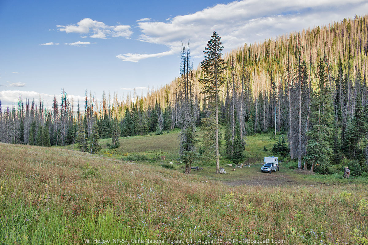
Mill Hollow, Utah
Why had I decided to come this way? Somewhere back along the road, when I'd looked at my maps, I searched out national forests that were high enough to have cool temperatures, might afford dispersed camping, and were roughly along a route that would take me back home. I used my Garmin navigation app to input various destinations and would check the travel time to see what would work and what would not. Thus I came up with this forest that had a few side roads which hopefully held campsites.
The first such road was FR-054, a wide gravel road. It climbed south from the highway. The first couple of dispersed sites were occupied by small trailers. I drove through the NFS Campground, which was adjacent and above the Mill Hollow Reservoir, but found it a bit claustrophobic so continued up the forest road. I passed a couple more occupied dispersed sites and finally decided to turn around and check the other roads. But on my way back down, I espied a site I'd not noticed on my way up, perhaps as the access road ran right by an occupied site.
 |
| My campsite along Mill Hollow Creek |
 |
| Another view of my campsite |
 |
| Baneberries - don't eat these. |
I set up camp on this site next to a creek that I'm going to assume is Mill Hollow Creek, though I never actually determined its official name. This site is about 4 miles from the highway. It was a nice campsite and I was happy to be there, but it also gave the impression of being over used, a bit worn down, perhaps you know what I mean. Though to the credit of those who came before, the site was free of trash and debris. There was also some sort of leafy groundcover that kept it from being too muddy after a brief rainstorm that moved through.
 |
| The little creek next to my camp |
I also noticed, especially when processing my campsite photos, that there are many dead trees in this area. I'm guessing the bark beetle has been active here for years. That might explain the signs on the road warning of logging trucks.
Friday, August 25
 |
| Wildflowers along the road |
On my way back down the mountain to the highway I noticed a traditional, mobile shepherd hut, then later on the highway, driving over the pass, there were sheep on both sides of the highway. If you drive through there, exercise caution.
 |
| Sheep were on both sides of the highway |
I descended into a green valley. I'd noticed the whole trip that Utah and other mountain states do big business in growing grass as fodder. At Duchesne, I turned east on US-40/191. I had driven from there to Vernal on my way up to the eclipse site, so my trip was more of a figure-8 now, than a loop.
From Vernal I continued east on US-40 toward Dinosaur National Monument. It was too hot to stop for a visit, however.
Trip continues in Part 3