
Before & After the April 2017 White Rim Trail Trip
Note: This post contains 0% White Rim Trail. If you want WRT start at Day 1.
Featuring:
Sand Flat Recreation Area, Moab
Canyonlands NP - Island in the Sky District
Little Round Top - BLM campsite outside Canyonlands
The San Rafael Swell - Swasey Cabin, Head of Sinbad, the Wedge & more.
March 31, April 1 and April 6 & 7, 2017
This blog entry covers the travel and camping on my way to my recent White Rim Trail adventure, and the travel and camping after I left the WRT.
Friday, March 31st
I left for Utah a day early, Friday, as I wanted to explore a bit first and take photos of the WRT from the overlooks on Island of the Sky district of Canyonlands National Park. The weather forecast included the possibility of light rain Friday, but then clearing for the rest of the week. This forecast proved to be inadequate.
I traveled up US-550 toward the Four Corners, stopping at El Bruno's in Cuba for a delicious lunch. About the time I crossed the Continental Divide, it began to snow. It was light at first and the air and ground temperatures were well above freezing. The farther I drove, however, the heavier the snow and the colder it got. The ground was being covered now, but the highway was fortunately only wet, not icy.
The snow turned to light rain around Farmington, I turned north at Shiprock and it began again to snow at Cortez. I snowed heavily along stretch between Cortez and Monticello. A few miles before Monticello slush began to accumulate on the highway. I stopped in town to grab dinner to go and headed north toward Moab. It was snowing heavily with poor visibility, but the highway was only wet. Most everyone was smart enough to drive slowly and carefully.
Sand Flats Recreation Area
I hadn't decided where I wanted to camp that night, but with the inclement weather I decided to try the Sand Flats Recreation Area just east of Moab. This is a popular spot for the off road enthusiasts. There are trails for modified 4x4s and some only for extreme vehicles. The famous Slickrock Bicycle Trail is there, too. Their website said they had 120 first-come-first-serve campsites, so I was chagrinned when I got there and the sign said "Campground Full".
I pulled into the parking area just inside the entrance and asked a fellow with a souped up & lifted pickup truck if the park was serious about the campgrounds being full. "No way," he said with authority, "There are plenty of sites left, just drive around to find one. That's what I did." Well, the sign was a bit more accurate than he was. Yes, I did find two pretty poor sites that were open, and with the continuing rain everything was getting muddy.
I spotted a sign for Walk-In Tent camping, and when I found nothing else I drove back to that spot. It had the advantage of a gravel, not mud, parking area and it was large enough that I could park there and there was still plenty of parking places for tent campers. There was one tent set up when I got there.
Naturally, about the time I got into bed additional tent campers drove in and unloaded their cars noisily. But the most "fun" was the middle-eastern fellow who was intent on serenading his woman accompanying himself on guitar. Oh, my!
Saturday, April 1st
 |
| Here is where I camped at Sand Flat |
Before leaving Sand Hill I drove farther along the road to the next camping area. Whereas those closer to the entrance were full of folks with modified 4x4's and rock climbers with toy haulers, this camping area seemed to be mostly mountain bike folks there for the Slickrock Trail.
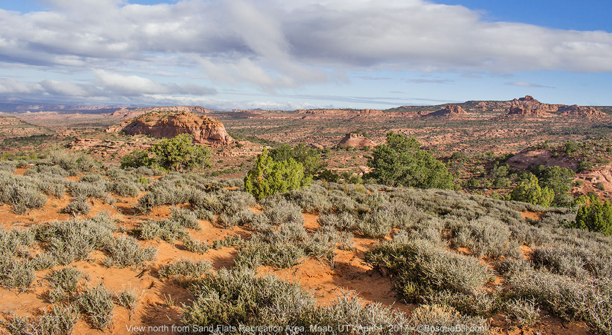 |
| A view of the Sand Flat Area. |
Moab
The road continues for miles farther, but I headed into Moab for breakfast, info and gas. I had breakfast at the Jailhouse Cafe, 101 N. Main St. I chose the Chorizo Eggs Benedict with their original spicy hollandaise and it was excellent. Good coffee, too. Recommended.
I stopped at the multi-agency visitor center, talked to a nice lady about dispersed camping and such, and bought a map for an area I want to explore on a later trip. Traffic getting out of Moab was horrible. It was backed up for miles behind the stretch that goes from 4 lanes down to two.
Canyonlands National Park
Driving into Canyonlands Island in the Sky the weather had not cleared up and the line at the entrance station was lengthy. I don't think I'm exaggerating to say it took half an hour to get to the pay station and show my pass. I commented on the number of folks and the ranger said it was spring break for Utah. Ah, that may have explained the large numbers at Sand Flat, too.
I wanted to visit Mesa Arch, that I had somehow missed when I visited the park two years ago. I also wanted to go to the overlooks where I could see the White Rim Trail below. Mesa Arch was crawling with tourists. I should have schlepped my tripod up the trail and tried that technique of taking 20 or so exposures then having Photoshop average them, making the people disappear as if by magic. Instead I took one with people, just so you know what you are getting if you go there, and a couple "close up" working around the other visitors.
 |
| Your typical view of Mesa Arch |
 |
| A tourist-free view of Mesa Arch and the White Rim area below the mesa |
I was going to hike out to Grandview Point, as I had not done that last time either, but I was concerned with the large number of people in the area for spring break. I was afraid the dispersed spot I'd talked my friends into using for a rendezvous might get taken if I got there late in the afternoon, assuming it wasn't occupied already!
Little Round Top
I had recommended we meet at a spot I'd stumbled upon two years ago. A lovely site at the foot of a large Navajo Sandstone dune. I subsequently named it Little Round Top. I was very relieved to discover there was no one there. So I set up and relaxed until my friends showed up.
Everyone was happy with the campsite and we got to know one another and enjoyed the evening. A short, but long lasting rainbow appeared north over the plain.
 |
| We enjoyed this rainbow from our camp. It lasted a long time for a rainbow. |
Sunday, April 2
 |
| Our camp at Little Round Top in the morning sun. |
The next morning we broke camp to meet at the Island in the Sky Visitor Center to begin our trip along the White Rim Trail. Read the first installment of that journey here, if you haven't already.
Thursday, April 6th
After completing the White Rim Trail, Dan and John headed home. Bob and I, each in our trucks & campers, headed up the highway toward the town of Green River. I was low on gas, so stopped at the extremely expensive gas station at I-70. I only bought 2 gallons, enough to get me to Green River without running out along the freeway.
San Rafael Swell
I met Bob at the gas station, then we drove in to town far enough to find the grocery store for fresh provisions. From there we headed west on I-70 to the San Rafael Swell area of the state. We took Exit 131, then stopped and aired down. There was a sign on the "main" road pointing us toward Swasey Cabin, our destination, but that was the last sign of any signs.
From our maps, it looked like the most direct road was through Earl's Draw, but we came to a place that was simply too narrow for our big trucks. We back-tracked and chose a more heavily traveled route.
 |
| A field of small wildflowers along the road. |
We stopped at the Lone Warrior pictograph.
 |
| Lone Warrior pictograph. So named, I assume, as it is the only rock art here. |
Swasey Cabin
We found Swasey Cabin - there was a sign here. I talked to an older gentleman driving an OHV who was very familiar with the area. I asked about Eagle Arch Canyon, as that was an area Bob and I had thought about visiting. He advised us our trucks would not be able to negotiate the road. I had seen on the county website that they referred to the road as a horse trail. I guess if we had OHVs like just about everyone else, we could have done it.
 |
| Bob, Swasey Cabin, and the rock pillar that tourists think is the Head of Sinbad. |
There is an interesting rock formation behind the cabin. I've seen many photos online with this sandstone tower labelled The Head of Sinbad, and with only a little imagination you can see his head and face. I asked the old timer about that and he replied that some folks did call it that, but I could tell from his intonation that the locals probably did not.
 |
| Canyon area behind (west) of Swasey Cabin. |
 |
| Swasey Cabin. In the background is the area in which we would camp that evening. |
Bob said that the whole area was called Sinbad, so we guessed the northern most part of Sinbad was his head - not necessarily that particular rock. I looked into this once I returned home and discovered the type of limestone that forms the hills and cliffs in this area is called Sinbad Formation. The article does not advance a theory as to why the name "Sinbad." Perhaps that was in use by the locals and the geologists simply borrowed the name for the unique rock formation.
Instead we looked for a dispersed campsite down a side road we'd spotted between the Lone Warrior and the cabin. At the end of that double-track we found a deluxe campsite. It was too windy for a campfire, so we turned in early.
 |
| Our campsite in the Sinbad Formation. |
 |
| Bob prepares dinner - chipotle sausages! |
 |
| Bob explored a little ways down the canyon behind camp. |
Friday, April 7th.
Dutchman Arch
Clouds had come in overnight, so we started off with overcast that was to last the rest of the day. We backtracked to the turn off for one of the 4WD underpasses to cross I-70. Bob navigated us through a maze of tracks to Dutchman Arch.
 |
| Dutchman Arch with the torso of Bob on top. |
Head of Sinbad Pictograph
Then he found the way to the Head of Sinbad Pictograph site.
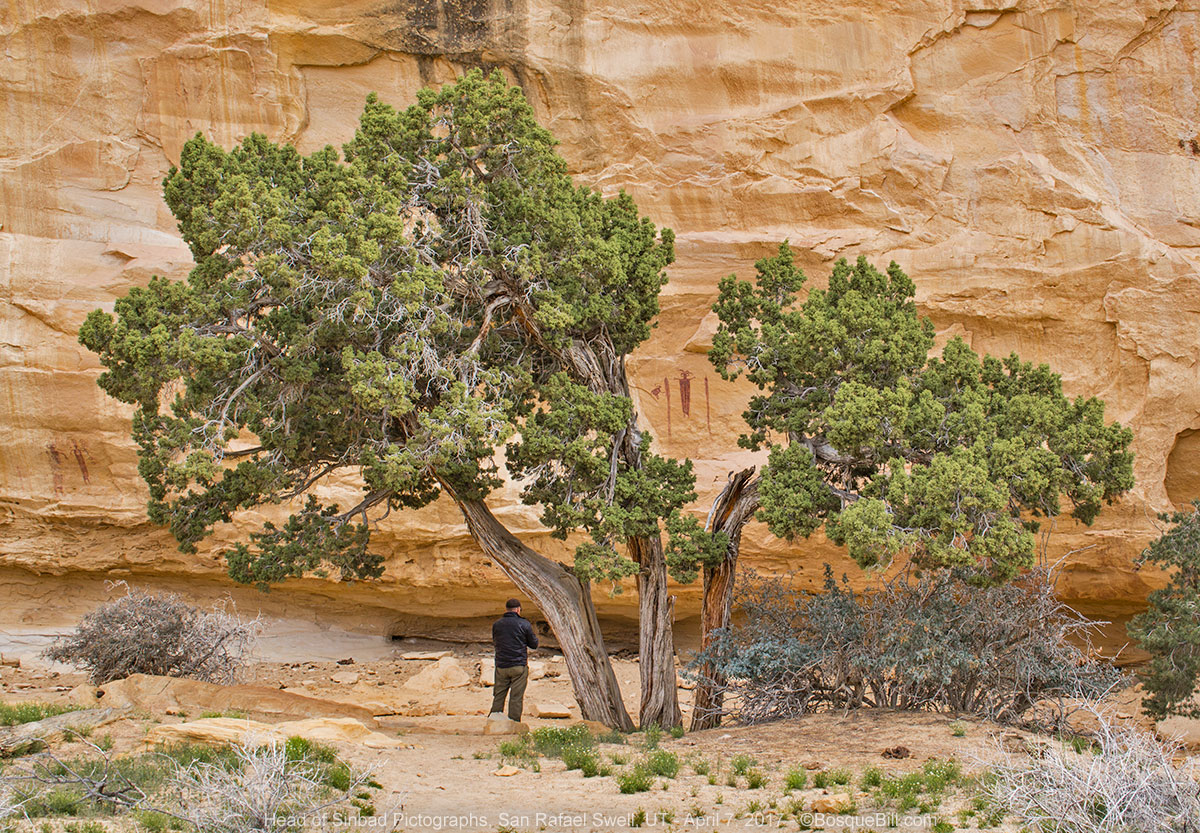 |
| Bob and the pictographs - one "in" the tree, the other to the left. |
 |
| Shaman and critter? |
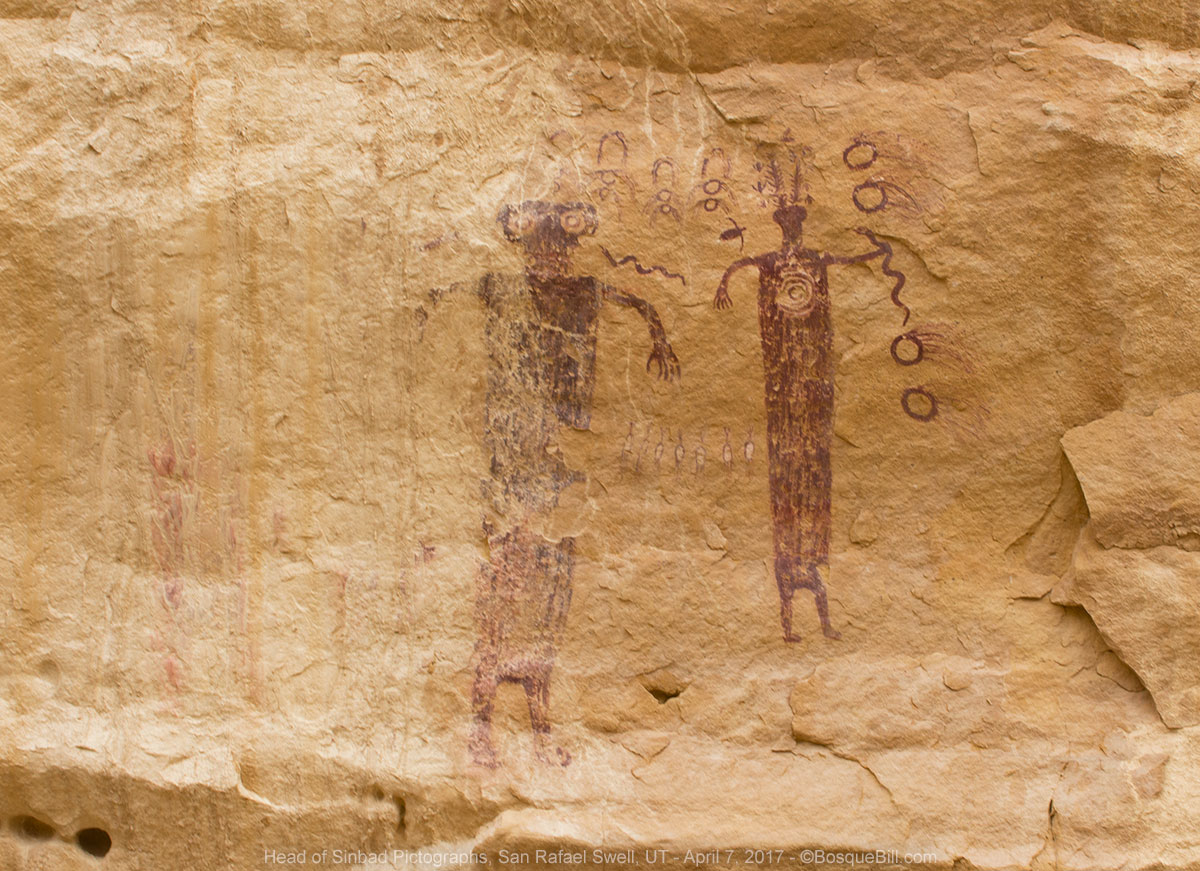 |
| Two mystical figures, one has nearly eroded away. |
 |
| Expansive view south from the pictograph site. I kept wishing for a shaft of sun to illuminate the limestone. Yes, that is I-70 cutting across the landscape. You can also see the road to Swasey Cabin, upper mid-left. |
Bob had wanted to explore up a road to the north, but it was marked as extremely difficult, so we crossed under the freeway at another 4WD underpass, where I came up against a rock and got a mud flap torn off. I retrieved the part and have since reattached it after a bit of a repair job.
 |
| Bob explores the left fork on foot. We went right toward the freeway. |
Buckhorn Wash
We drove north on Cottonwood Road to the San Rafael River where the old swinging bridge can be explored on foot. There are two fee campgrounds, one on either side of the river.
 |
| The famous old swinging bridge across the San Rafael River. |
From there we drove north on Buckhorn Wash Road to the Buckhorn Wash Pictographs where we paused for photos. I'm just including one pictograph photo here. You can see more here.
 |
| Just one of the pictographs in this large panel. |
Wedge Overlook
We continued north up to the Wedge Overlook, there were lots of folks disperse camped along here. This famous spot provides a vantage up and down the San Rafael River Canyon, a.k.a., the Little Grand Canyon. There are lots of free BLM campsites in this area and lots of folks enjoying them during Utah's spring break.
 |
| Panorama of the "Little Grand Canyon" as seen from the Wedge Overlook. |
I was not feeling very well, myself, so headed toward home by backtracking to I-70. From there I took UT-24 south to Hanksville where I filled the tank. I then followed UT-95 to the southeast.
North Mule Canyon, Cedar Mesa
I had it in mind to camp in Cedar Mesa and hoped my favorite spot in North Mule Canyon would be available. I was prepared for disappointment as there were lots of people disperse camped in the area, but I lucked out and no one was in "my" spot!
 |
| My favorite campsite in North Mule Canyon. |
OMG, were the frogs ever singing that night! They were loud! Good thing I love the sound from when I was young and there were chorus frogs where I grew up.
Saturday, April 8th.
I had a little breakfast, made coffee, and hit the road. I took 95 east to US-191 where I turned south. I took the back way to Montezuma Creek via UT-262. On trips past I tried to find Red Mesa Road that heads south into Arizona, but had failed as it's not marked. This time I had prepared myself and knew I had to make a left turn after crossing the San Juan River. I was happy to finally find it and as I'd hoped it was a much more interesting route than the way I'd gone in the past.
At Red Mesa I turned east on US-160. I stopped at Teec Nos Pos for gas at the trading post. Read about the interesting murals I saw there on this post.
From there I took US-64 into Shiprock, NM. I stopped again at That's A Burger, which is locally owned and operated. Really nice folks and good food with a Navajo/New Mexico accent.
If you've read this blog before you probably know the way home as well as I do. From Shiprock to Farmington, take Country Road 5500 around the traffic in Bloomfield, then US-550 back to the Albuquerque area.
And as ever, thanks for reading.
No comments:
Post a Comment
Thank you for taking the time to comment. I really appreciate it!