
Part 3 of 3
Hubbell Trading Post, Canyon de Chelly, Window Rock, Zuni Mountains
Continued from Part 2 - Began in Part 1May 4, 2016 (continued)
Remember to click any photo for a larger version - highly recommended.In many cases I have posted only a few site photos in the blog. Look for links to full photo albums.
Hubbell Trading Post National Historic Site
From Petrified Forest, I drove east on I-40 for a little over 20 miles where I exited onto north US-191 for the drive to Ganado, AZ, location of the Hubbell Trading Post (NPS site.)
This site is the oldest continually operating trading post in the Navajo Nation. Some visitors leave unimpressed, but I find it fascinating. Don't forget, if you visit this area in summer, Arizona does not observe daylight savings time, but the Navajo Nation does.
 |
| Main Entrance |
 |
| General Store; first room inside entrance. |
 |
| Basket Room |
 |
| Blanket Room |
 |
| Another view of the Blanket Room |
View my full Hubbell Trading Post photo album.
Canyon de Chelly National Monument
I was returning to Canyon de Chelly primarily to take photos of Spider Rock in better light than I found on my last visit late last year. From Hubbell I continued on 191, stopping only for gas in Chinle, then directly to the Spider Rock overlook. The sky was full with small, medium, and large puffy clouds. That was beautiful to see, but a challenge to photography. I'll show you two photo versions, one with clouds and one where the entire canyon was covered in cloud.
 |
| Spider Rock - Cloudy Version with strong Orton effect. |
 |
| Spider Rock - Contrast Version with mild Orton effect. |
After I left Spider Rock I camped in the native-owned Cottonwood Campground with lots of other folks. Although cars and RVs were lined up to enter and it took a while to advance to the entrance station, there were plenty of sites for everyone. The weather was mild, but the campground should be pleasant even in warmer times due to all the cottonwood trees. This early in the season the leafy canopy is not fully developed. There is no dispersed camping anywhere nearby; there is one other private campground near the end of the south rim road.
 |
| Cottonwood Campground located off the highway near the park entrance. |
I saw my friends from the night before come in and camp. I also struck up an interesting conversation with some folks I'd seen at Spider Rock. They were from Washington state and were visiting sites in Indian country that had been featured in the famous mystery novels of Tony Hillerman. As I am also a fan of those Navajo detective stories, we had lots to talk about.
May 5th
Canyon de Chelly (continued)Antelope House
I intended to visit the sites along the north rim that I didn’t get to last fall. My first stop was the Antelope House overlook. At the visitor center they recommend the north rim for mornings and the south rim for afternoon, but I discovered you can be too early for good photos on the north rim. I arrived at the first stop at 9am, but had to hang around until 10am before the full ruin was in the sun. Not that hanging around that spectacular scenery on a beautiful morning was much of an imposition.
 |
| Beautiful view of Canyon del Muerto from the NE overlook at the Antelope House site. |
Antelope House is named for the beautiful pictographs painted on the cliff face above the ruin. (Though it should really be named Pronghorn House, as this native artiodactyl mammal is not an antelope.) The ruin is dated at 1300 A.D. the illustrations are attributed to a Navajo artist in the 1800s.
 |
| Antelope House at the foot of a sheer cliff |
 |
| Antelope House Pictographs. They are just above the ruin and to the left. |
While waiting for the canyon shadow to recede, I met an interesting amateur photographer from Hamburg. Achim was driving around the southwest for the entire month of May visiting as many parks and scenic areas as he could, as far north as Grand Tetons and Yellowstone, before returning to Phoenix for the flight home. We had a fun discussion about southwestern scenery and photography, and our conversations have continued via email ever since.
 |
| Note the colorful chin on this lizard. |
Mummy Cave Ruin and Yucca Cave Ruin
These two ruins are close to one another and the northern most in the park. Mummy Cave Ruin is one of the largest in the canyon and the details can be more easily seen than with others due to the contrast between the light walls and dark rock floor. Yucca Cave Ruin is one of the few located near the rim of the canyon.
 |
| Mummy Cave ruin is midway up the cliff at left. |
 |
| Composite telephoto panorama of the Mummy Cave ruin. |
 |
| I spotted this Peregrine Falcon fly up to this perch. The falcon never moved where I could get a better photo. |
 |
| Yucca Cave ruin high above the canyon floor - probably accessed from above. |
View my full Canyon de Chelly photo album.
From the last overlook I continued north on the rim road, Indian Route 64, to IR-12 and down to Window Rock.
Window Rock, AZ
While looking for the "Navajo Inn" to have lunch in a Hillerman novel, I found the actual Window Rock. I photographed it and the Code Talker statue. There was a Quality Inn with its Diné Restaurant. I'm guessing that was the place, but with the name changed in the book. I stopped in for a late lunch and had their Navajo Taco. I thought it was a bit expensive, but I had a pleasant table with a nice view of the courtyard and fountain, so was happy. The restaurant seems to be popular with the locals.
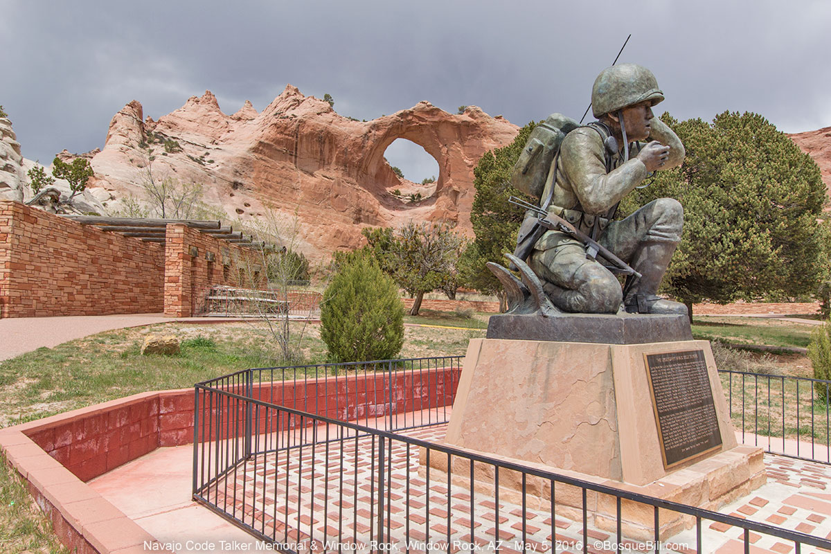 |
| Window Rock and the Navajo Code Talker Memorial |
Zuni Mountains, Cibola National Forest, NM
From Window Rock I drove to Gallup, NM and got on eastbound I-40. After just a few miles I turned south on NM-400 at Wingate. My intention was to drive through the Zuni Mountains on FR-50. This small mountain range is located south of I-40 roughly between Gallup and Grants. I had never been in this exact piece of New Mexico and was curious what was here.
 |
| You lookin' at me? |
The two forest service campgrounds in the McGaffey vicinity were both closed, not that I had intended to stop, just a FYI. The asphalt road turned to gravel. The road was very good for a number of miles passing through meadows and grasslands, and I saw a herd of elk cross the road ahead. I was following FR-50 which looks like a good, through road on the map. At a junction by a large ranch there was a sign: “Primitive Road - Not Suitable for Passenger Vehicles.”
That didn't concern me too much at first, but over the next several miles, slowly following the route, I decided the road was barely suitable for high-clearance 4-wheel drive vehicles. Yikes! It would have been impassable just a few days before due to rain in the area. The mostly hardened ruts were extremely deep and there were many tricky places where I held my breath. For all the effort, the scenery was that of your basic Ponderosa forest - nothing extraordinary, nothing to call for a repeat visit.
 |
| A view of Mt. Taylor as I came down out of Zuni Mountains. |
I finally came to FR-480 which was in much better shape. I followed it to FR-178, though remnants of wildfire, to FR-180 (a.k.a., Zuni Canyon Road), to Grants. If you ever pick up a brochure for the Zuni Mountain Historic Auto Tour (for railroad buffs) ask a knowledgable local about road conditions before you start out. The last sites, north on 50, would not have been accessible to a passenger vehicle and I saw no sign at that end of the road warning of the primitive conditions.
 |
| Pretty roadside wildflower. |
On the way home.
I rejoined I-40 and drove home, arriving at dusk. That last section in the Zuni Mountains notwithstanding, this was an extremely enjoyable trip with lots of great scenery and camping. It was one of those rare trips where all the pieces fell into place.
Thanks for reading along.
Loved the photo of the Peregrine! Good obs!
ReplyDeleteI waited and waited for the bird to move out onto the rock perch that would give me an unobstructed view, but no luck. Still, I got most of him/her, and it's my only wild Peregrine photo!
DeleteThanks for your comments!
Looks like spring is treating you well, Bill, with a trip to and through such classic southwest places! These are places I visited as a kid with my parents, wonderful memories from many many years ago. Your photos and stories have taken me back. Thank you for reminding the urge to return!
ReplyDeleteSki, thanks for your thoughtful comment. I apparently remembered nothing about the Petrified Forest - of course that was about 55 years ago :-O
DeleteThe photos are stunning, Bill. Truly stunning. With all three years I've been in Iowa, the landscape and even the wildlife looks almost surreal to me. I particularly love the narrative, too. I feel like I've had a glimpse of being an adventurer without leaving the familiarity of my home. Thanks for sharing all of this!
ReplyDeleteThanks, brother. I'm happy you like the photos and I do try to give a bit of story without being tedious in the mundane details. You guys should really plan a sabbatical and get back out this way to see for yourselves.
DeleteSounds like an excellent idea!
Delete