
First Trip of the Season
I wanted a four or five day trip to "shake down" to start the year. As it was early in the season, a southern venture sounded best. I had made a few trips down to the Chiricahua Mountains, in SE Arizona, in years past to bird and stayed at the lodge in Portal. I'd noticed great camping areas those times, so wanted to try those out, and enjoy the scenery.
I had only been to the Gila once as a small boy, fishing with my dad, but had heard great things about it. I also wanted to check out the Gila Cliff Dwellings.
I would also test out my newly purchased inReach satellite communicator. I bought it primarily to provide emergency communications in the outback where cell phones don't work. However, even their basic, Safety, plan allows sending unlimited free pre-set texts. I planned to use those as "breadcrumbs" to let friends and family know where I'm driving, hiking and camped. The basic plan also gives you 10 free-form texts per month with additional only 50 cents - from anywhere on the globe!
I also wanted to try out my Garmin StreetPilot® Onboard for iPhone North America navigation app for the first time. it's a one-time purchase on the AppStore. You chose which version by map coverage. I chose North America which includes Canada and Alaska in case I want to wander up that way sometime. All the maps and POIs are stored on the phone, after you download them, so you don't need a data connection while traveling or have to worry about the size of your data plan.
Monday, April 14
Albuquerque to Portal, Arizona
For once I started out a road trip with the wind literally at my back. I was able to fly down I-25, which is good as it is not a very interesting drive. By the time I needed to cut west the wind had died down. Excellent. Lots of RADAR traps just west of Hatch, NM, if you're taking the NM-26 shortcut between I-10 at Deming and I-25 at Hatch.
The Garmin navigation app worked very well, though the first time I connected, the prompts wouldn't play through my truck's audio system. After stopping for gas at Lordsburg, it miraculously began to speak. It is not an inexpensive app, but a fraction of the cost of a stand-alone unit, plus I got it half-off on Black Friday last Thanksgiving!
I bought one of those phone holders that mount in the CD slot on your dashboard. That worked pretty darn well, too. It makes it easy to see the phone display without blocking the view through the windshield, though may not be as stable as a permanent mount on a rough road.
 |
| The Portal to Cave Creek Canyon and the Chiricahua Mountains. The road goes right up through the gap in the center of the photo. |
Camping at Sunny Flat
It is always a delight to drive up that desert road to Portal, then make the turn toward Cave Creek Canyon and see the gorgeous mountains and all the greenery stretched out ahead. Once in the canyon, I looked over both the Stewart and Sunny Flat campgrounds and chose a secluded spot at Sunny Flat. The sites with the best views were already taken, but there were still several sites available in both CGs, and I assume Idlewild CG, as well.
I hadn't been back to the area since the terrible fire two years ago and I wasn't sure what I'd find, so stayed in the campground rather than try to find a dispersed site. Plus, my site was very close to the areas I'd planned to hike and explore. It worked out well, especially as most of the folks in the CG were older birders and very quiet - no families with screaming kids.
 |
| Not so sunny campsite at Sunny Flat Campground |
Walking up South Fork
I had arrived in time to take a walk up South Fork after reserving my campsite and before parking the truck to raise the roof. It was a beautiful late afternoon, the canyon was already in deep shadow, but there wasn't a whole lot of bird activity. I did enjoy the antics of a pair of Painted Redstarts, but with the low light and their high activity the photos didn't turn out well.
 |
| Fern along South Fork Canyon |
Back in the campground that evening one of my fellow campers pointed out where an Elf Owl was peeking from his nest hole in a sycamore tree.
 |
| Elf Owl drowsily peeking out of its sycamore nest hole |
Tuesday, April 15
Birding in the Campground
I decided to bird the campground before driving to the trailhead this morning as I heard plenty of birdsong while making breakfast. There was quite a bit of bird activity in camp and especially at the site where the campers had set up 3 hummingbird feeders, a seed feeder, a water drip, scattered seed on the ground and placed a half-dozen orange halves on tree branches!
 |
| Scott's Oriole |
 |
| Lincoln's Sparrow |
 |
| Blue-throated Hummingbird photo bombing an Acorn Woodpecker - "Hey! That's my feeder, ya bum!" |
 |
| Bridled Titmouse giving me the stink eye |
Walking up South Fork
It was a beautiful morning, though relatively quiet bird-wise. Still, I met a number of other birders and exchanged notes. I'd run into those same friendly folks later in the day at various locations. "Hi, Vinny!"
The scenery is quite dramatic along South Fork. There is a lovely little stream, surrounded by junipers, sycamores, pines and various other trees. There are all manner of plants, ferns and flowers along the stream and trail. Looking above the tree canopy you can see the dramatic canyon walls of various colors of rock - reds and creams, with green and yellow lichens and plants.
 |
| Looking up at the top of the canyon through the Arizona Sycamore |
 |
| A single blossom of one of the many Seep Monkeyflowers near the creek |
 |
| Yellow Columbine also grows well in my yard in Albuquerque |
 |
| I'm always fascinated by the mix of mountain trees and desert plants in the canyon |
Relaxing at SWRS
After my walk up the canyon, I stopped back at my campsite for lunch under the trees, then drove the short way to the Southwestern Research Station of the American Museum of Natural History.
Beside the researchers and students, SWRS allows visitors onto the grounds to look for birds or to sit on one of the benches and watch the hummingbird feeders they keep for that purpose. This is generally a good place to spot the Magnificent, Violet-throated, and Black-chinned Hummingbirds. Later in the season you might find rare, tropical species there, as well. Acorn Woodpeckers love to visit the feeders, too, for a treat of sugar water.
I ran into a nice couple from Alabama I'd met up South Fork. They invited me to share their bench and we swapped stories and watched the birds companionably.
There is a small spring feed stream that runs through their grounds. Although I didn't find any exotic birds along the stream this time, I did find and photograph a Red Rock Skimmer dragonfly and Springwater Dancer damselfly.
 |
| Red Rock Skimmer |
Herb Martyr Rd, then up to Onion Saddle, Barfoot Junction, and Rustler Park
After leaving the station I decided to drive around the area and up FR42 to the top - to look for birds and landscapes to photograph, but also to determine the extent of the wildfire of two years ago. Happily, I hadn't seen much evidence of that along Cave Creek.
I first drove Herb Martyr Road to the end, noticing there was no one in the "dispersed" (as Coronado N.F. calls it) campground at the end. It looked like one could park a pickup camper there in a pinch. I stopped along Cave Creek on my way back down the road to check for dragonflies. I found another Red Rock Skimmer and this lizard.
 |
| Fence Lizard - I was not able to determine exactly which species |
I then drove on up 42. I noticed a couple of dispersed camping areas - one was full of trailers and tents. As the road winds up the hill I admired the views and the wildflowers along the way. I passed the turn off to Paradise and continued up the mountain. As I got closer to the top, I started to enter areas that had been burned, though only in pockets, albeit, some of those pockets were quite large.
 |
| Coulter's Lupine |
On arriving at Onion Saddle, the whole west side of the mountain that I could see was heavily burned, much worse than the east side. I guess the Pinery camping area would be essentially gone.
I turned up the road toward Rustler Park. A road sign upon entering Cave Creek announced that it was closed, but the road was open. Again a mosaic of burned and unburned areas. I took the turn toward Barfoot Park and drove in less than a mile, that part was unburned, but I suspect farther west I would have hit the burn area.
 |
| High in the Chiricahua Mountains - a happy camper! |
 |
| More lupines along the road |
I then drove up to Rustler Park. You could drive right up to the closed gate at the entrance and the view of the park proper was heartbreaking. The area was totally devastated - all those gorgeous, tall trees gone.
 |
| View of the Chiricahua high country |
I drove back down the mountain to my campsite where I experienced a quiet evening.
Wednesday, April 16
Birding Paradise Rd
Before I left PortaI wanted to check the spot where on my last visit to this area I saw a Montezuma Quail. This species has a very cool, almost geometric pattern on its head and I've only ever seen them once. The drive up the road from Portal toward Paradise is unlike those roads farther up the mountain. This area is much drier with scrub, though with cottonwoods along the canyon bottom.
I admit I was not "up and at 'em" very early, so didn't see much on the road. I did find the little turn-off I'd stumbled upon last time and parked in the shade of a cottonwood. I spent some time walking up the dry creek bed. I heard and got a glimpse of a large covey of Gambel's Quail, heard then saw a pair of Pyrrhuloxia, but no Montezuma Quail.
Should have taken photos. Oops.
Portal to Silver City to the Gila Mountains
I reversed course, headed back through Portal, then up to the freeway, stopping for gas and to check email at McD's in Lordsburg. I took NM-90 north east from there over the Burro Mountains, past the edge of the Tyrone open-pit copper mine to Silver City. This historic mining town with its art community is a destination for some, but not for me today. From Silver city I took NM-15 north, through the hamlet of Pinos Altos. This is a beautiful drive, assuming you enjoy a narrow winding highway through pine forest and rocky cliffs. It goes way up, with a view of the Gila Wilderness, then way down.
After passing the junction of NM-35 the highway begins to climb again, through some interesting mineral soils up along a long ridge. Then eventually back down where it crosses the Gila River. Just before the bridge, however, is the turn-off to the Grapevine campground which was my destination for the day.
The Gila River
I chose to camp here for two reasons. It afforded campsites right next to the east fork of the Gila River, and it is the location where a rare dragonfly was spotted last summer. Though it was early in the season, maybe I'd lucky.
 |
| Gila River (photo from tomorrow, if anyone cares) |
There were folks already in two of the most attractive sites, but one group looked like they were there just to let their grandkids play in the river. So, I parked in the shade, put on my water sandals and shorts, and headed for the Gila River to look for dragonflies. I didn't see a single one, but it was a beautiful afternoon to wade in the cool water and enjoy the gorgeous view. I also spotted this pretty water flower.
 |
| Only the blossom of this white Crowfoot is above water |
Grapevine Campground
As hoped, shortly after I returned to my truck the grandparents drove off with their kids and I claimed their campsite with its "private" beach on the river. The campground is named for an enormous, old grapevine. I took a photo, but as it is still dormant from the winter, it just looked like an old dead tree, so I didn't include the image here.
 |
| Campsite next to the east fork of the Gila River. Note my chair overlooking "my" beach. |
I set up my camp chair in the shade, as it was a warm afternoon, facing the stream. There were Turkey Vultures soaring on the thermals above the canyon walls and I got out my binoculars to take a look. I was delighted to quickly spot a Zone-tailed Hawk in the flock. For those who don't know, this hawk species has evolved to look and behave remarkably like the Turkey Vulture. This adaptation allows it to hunt "under cover" of the vultures and therefore its prey on the ground dismisses the flock as harmless scavengers, not predators.
 |
| Zone-tailed Hawk pretending to be a Turkey Vulture |
Always a pleasure to fall asleep listening to the murmurs of a river or stream.
 |
| Beautiful sunset at my campsite. Speaking of Turkey Vultures, there are several roosting in the tree, top center; see the dark blobs? |
Thursday, April 17
Morning in Camp
As I went through my morning routine of percolating coffee and having breakfast, I could hear warblers in the trees outside. I grabbed my camera to walk up the creek and around the campground. One of the problems with warblers is that they are usually in the high tree tops hopping from leafy branch to leafy branch. I lucked out though when I found a Yellow Warbler near the top of a tree that not only wasn't too tall, but had not leafed out yet. Looks like he was trying to attract a mate.
 |
| Yellow Warbler singing his little heart out |
 |
| Walking back to my campsite along the Gila east fork. See my camper on the left? |
Gila Cliff Dwellings
I packed up the camper and headed on up the highway for my first ever visit to the Gila Cliff Dwellings National Monument. I stopped at the visitor center, but as usual didn't have the patience to sit through the video presentation (why do they always keep those small rooms so warm?) I did enjoy the exhibits. The best feature of the visitor center for campers is a free trailer dump station, if you need to clean out your porta-potty, and a hydrant of potable water. Important, as most of the national forest campgrounds in this area don't have water. I was in good shape, though I hadn't filled my camper's water tank, yet, in concern of possible overnight freezing.
I'm not going to go into detail here on the cliff dwellings other than to say they were very, very interesting and well worth the trip for those passing through the area. I've posted sixteen photographs on my New Mexico Bosque Bill website. I encourage you to click over to follow my journey up the canyon and through the dwellings. Here is a teaser:
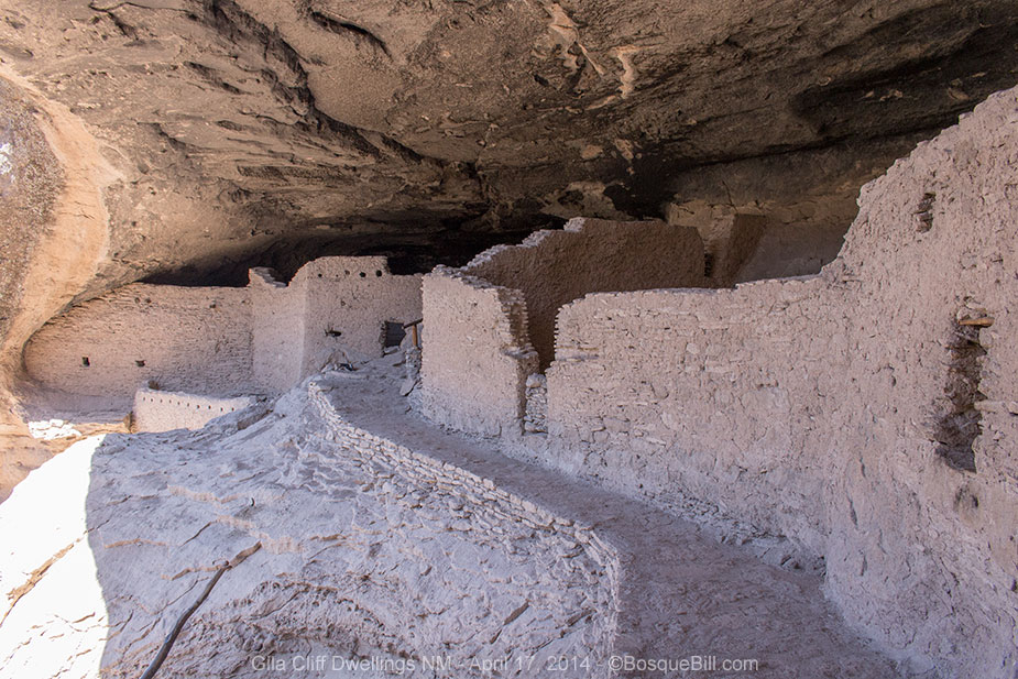 |
| One of the Gila Cliff Dwellings. Click URL above for more. |
Gila River Redux
I returned to the Grapevine CG to park in the shade of a tree to have lunch, and then to head back to the river to see if there were any dragonflies out mid-day. And this time I remembered to bring my walking stick to help me keep my footing while wading in the water.
 |
| Gila River, looking downstream at the highway bridge and flood debris |
There were a couple of dragonflies, but neither landed for a photo. I think one was a Pale-faced Clubskimmer, but all I could see of the other was that it seemed brick-red.
Driving out on NM-15 and NM-35
NM-15 ends at the cliff dwellings, the highway is strictly an up-and-back affair. It is a vehicular peninsula poking up into the Gila Wilderness, providing access to the national monument, Gila Hot Springs, the river, trailheads and campgrounds.
Again it struck me that the Gila is a very dry forest area, naturally and climatically so. Although experiencing drought, like much of the west, it has always been fairly arid, so is not suffering too much. The trees are, by necessity, not close together as to not compete for moisture. In the canyons, however, the landscape provides for concentration of what little rainfall there is and the trees are taller and closer together. Many of the deciduous trees in my photos are not dead, it's just too early in the season for many of them to have leafed out.
As I was intending to head east again, I took NM-35 at the junction. This highway is not as narrow and twisting as NM-15 was, up from Silver City. Not as pretty either, but still very pleasant. I passed Lake Roberts and its campgrounds, but didn't stop. From my glimpse from the highway, it looked low. I also noticed they seem to be building a new concrete dam.
I passed through the tiny village of Mimbres, then took NM-152 east toward the mountains where I planned to camp for the night.
Campgrounds along NM152
The drive up into the mountains is a climb and also dramatic. I had seen from my map that there were four campgrounds along the highway, all on the west side of Emory Pass. I thought I'd check each of them as I got to them, then camp when I found a congenial spot.
 |
| Eastbound NM-152 just past the turn-off to Lower Gallinas campground |
First was Lower Gallinas which they state is not recommended for trailers, as there is a sharp drop into the canyon and a narrow road though the campground. There was a vault toilet & garbage receptacles, a small brook running past a number of the sites, lots of pines and junipers and not much else. There were about 8 sites, none occupied. It didn't grab me, so I drove back onto the highway.
[Update: when I drove though on 152 in August 2015, Lower Gallinas CG seems to have been permanently closed by the forest service.]
Continuing to climb up the mountain through spectacular rock formations, I came to Upper Gallinas. It is not much more than a wide gravel lot cutting a curve in the highway, though below grade. No pull-in sites, one would just parallel park and walk to a table or tent site. One of the duck dynasty's buddies was there sittin' in his chair beside his old trailer, generator chugging away in his pick-up truck bed below an enormous American flag. I waved and decided to keep on truckin'.
Next up the road was Railroad Canyon CG which was just one small area and in this case full to overflowing with a large party; perhaps an extended family with lots of trailers and tents. They even had a portable movie screen set up!
Evidence of one of the wildfires that hit the Gila last summer began to be more apparent. Dead trees covered the upper slopes and trail heads were closed. The last campground was Iron Creek. This was little more than a road that one could park along, but not drive off. The road paralleled the highway, across from a dry creek bed. Though forested, it was close enough to the highway that you could watch the cars drive by. Though much larger and greener than Upper Gallinas, not really appealing.
That was it for the official campgrounds. It was still early enough I thought I'd continue on to at least the summit to see if there were any side roads that would afford dispersed camping. There were not. There was a view point at the pass that provided a wide panorama to the east - the mountain, foothills, and plain beyond. This was marred by the fact that almost the entire eastern slope was heavily damaged by fire. Very sad. A photo is farther down the page.
Camping at Lower Gallinas CG
[Update: when I drove though on 152 in August 2015, Lower Gallinas CG seems to have been permanently closed by the forest service.]I realized the most attractive campground of the four was the first one I'd come across, Lower Gallianas. It was only about 6 or 8 miles back. I drove through the campground again and this time there was a family setting up at the end of the track. I did find a pretty nice site about mid-way in, next to a giant Alligator Juniper with a picnic table that was handy to a level spot for my camper. It was right next to the little creek, which chuckled to itself the entire time, and a steel fire ring already stocked with firewood. This turned out to be a very pleasant little campground which I strolled round after dinner. Not any trails or attractions for a longer stay, however.
 |
| My campsite back up to Gallinas Creek with its giant juniper |
Friday, April 18
Morning Drive
I'd been blessed with wonderful weather the entire trip - clear skies with little to no wind. This morning it was overcast. I also managed to twist my back painfully, so packing up was a slow painful process.
I retraced my path up the mountain, then down the twisty highway on the other side, again lamenting the fire that turned what must have been a beautiful mountain side into dead wood and ash. The road passed an old mining town, though no historic buildings that I could see.
 |
| View from Emory Pass from the day before |
On the drive I reflected on the fact that the Gila National Forest primarily provides free campgrounds with limited facilities, which works well for us truck campers. Most have a vault toilet or two, some have picnic tables and/or steel grills, very few have drinking water. Though arid, there are wonderful views, and I'll want to come this way again.
Percha Dam State Park
When I came to I-25, I decided to head south a few miles and check out one of the state parks along the Rio Grande that I'd heard about for years as a great birding spot and also a location for finding dragonflies.
The developed part of the campground was just a big loop with lots of trailers, many looking like they'd been there some time. There was an undeveloped area, with fewer trees, but closer to the dam. I parked for a moment to walk down and check the small amount of water flowing through the dam and downstream to see if there were any Odonates flying. I wasn't optimistic as they prefer not to fly when it's cloudy - has to do with their sight depending heavily upon polarized light from the sun. As expected, no dragonflies, so I returned to my truck and headed north.
I'd intended to check out the campground at Caballo Lake State Park for a future visit, but the volunteer at the gate wouldn't let me in without paying, not even for a quick drive through. Sheesh, guess they don't want to attract new patrons.
Gas & Lunch in T or C
I took the old highway north to the town of Truth or Consequences, NM, near Elephant Butte Lake. I was thinking how much nicer and more scenic it was to drive up the two-lane highway, thinking of the way it used to be to travel. Then I realized how miserable it would be filled with slow moving trucks and lots of traffic - maybe the freeway isn't so bad after all.
I stopped for gas in T or C, then pulled in to a little cafe that had a few cars outside. When I sat down they asked if I wanted chips and salsa, so thought it might be worth ordering Mexican food. I ordered a plate of traditional New Mexico stacked cheese enchiladas, and they were delicious. The sopapillas were even better! Fortified I headed back to the freeway for home.
If you're too young to know the story of Truth or Consequences, NM, get on the Google machine.
Headed for Home
Once again I lucked out as the strong winds were from directly behind me. A nice uneventful run up the freeway back to civilization.
I declared the trip a success. The weather was great. The scenery a joy to behold. The truck ran very well. Absolutely no problems with the camper or the new gas carrier. I did make a small list of little items to take care of for my next trip, that's what a shake-down is for, but fortunately nothing major.
The inSight communicator worked very well on the trip and I had emails waiting for me at home with the latitude and longitude of each breadcrumb, including where I camped that night. Cool. Friends subsequently reported successfully receiving texts or emails, as they chose, of my breadcrumbs. This will be a great asset to carry along in the camper and on my solitary hikes. Wonderful for the peace of mind in the wilderness, too.
Thanks for reading along.
What a great shake-out trip Bill. I feel bad that it's taken me this long to get back to your blog, but super-impressed with your writing and photos (once again). Unlike social-media posts that can get a quick +1 or thumbs-up based on a single photo, your blog deserves better treatment. I like to sit and read through the whole trip undisturbed, and that was the treat I got today. I learned a whole lot about birds, animals, archeological sites and more. Obviously I have to work my way forward, but you have reminded me why I have your blog in my RSS feed. Cheers, Peter (from cold, wet Jan Juc, Australia)
ReplyDeleteThanks, Peter, for your thoughtful comment. If you liked this post, then I'm sure you will enjoy later ones as well. But take your time and look at them when you have a quiet moment.
DeleteYou are doing better than I am. I've added your blog to my RSS feed, but haven't gotten around to delving into your photos and philosophies.
Hi Bill, I post the photo and text to G+, so you can always quickly check the photo without having to read ;-) I wouldn't delve into my philosophies too much; it's winter here, so I'm not getting out. I'm using the time to practice writing in a bit more depth, which I must say I find difficult and slow. I think I'm getting repetitive too, with my "do it now", "don't delay" exhortations, when I should be actually doing :-) For me it's quick photo posts to Instagram these days, and occasional visits to Google+. Trying to work out Facebook at the moment too, so my family might see some of my photos. All good use of short daylight hours and rubbish weather :-) Cheers
DeletePeter, I do look at your photos on G+, but since you took the time and effort to write a post, I felt that as a friend I should take the time to read it rather than just adding a +1… only fly in the ointment is my poor execution of this concept ;-)
DeleteOkay - so we'll call it a draw, because we both have good intentions and similar execution strategies :-)
DeleteEnjoy your summer; hope it's not too hot for you this week.
(sorry, moved this back under the right thread...)
This comment has been removed by the author.
ReplyDelete