Monday, October 27, 2014

Autumn Color: Colorado Part 3

In Search of Autumn Color


A reprise of the map showing my overall journey. Presented as a convenience.

Part 3 of 3: October 7th through the 9th


This is the last installment of the story of my trip to Colorado to find and enjoy colorful fall leaves. In this section I drive south from Leadville, along the Arkansas River, then explore Marshall Pass, and finally take the Silver Thread Byway, CO-149, toward home.

I also ran into a bit more adventure than I'd anticipated, so read on.

Tuesday, October 7th (continued)


I headed back south from Leadville on 24. This pretty valley is the headwaters of the Arkansas River. I was still not sure where I wanted to go from here. The high clouds had continued to build and the weather report at the ranger station noted the increased chance of showers in the following days. I decided not to take Cottonwood Pass back over to Taylor Park, figuring those high country aspen were likely past peak and into bare branches. South of Buena Vista 24 heads east and US-285 comes in from the north; I continued south on 285.

I passed by the dramatic appearing Chalk Cliffs with the thought to explore up that road on another trip when it would be safer to head up into the high country. I found cheap gas in Poncha Springs and asked an old timer there if there wasn't a ranger station just up US-50 from there. He said it was just a ways up on the right, so I headed east in search of local information. Turns out his directions were out of date; the old station had closed. I had to stop at the Chamber of Commerce visitor information to learn a new, modern station had been built just southeast of Salida along 50.

A very nice and knowledgable lady at the Salida Ranger Station answered my questions about various routes and alternatives. I liked her suggestion to take Marshall Pass Road, FR-200, back south on US-285. She said it was one of her favorite drives for fall aspen. She also suggested I might like to camp at O'Haver Lake campground, but cautioned it might be a bit smokey, as there was a prescribed burn nearby.

Marshall Pass


I took that route and looked at the campground. It was pleasant enough, but more of a destination for those who want to spend time lake fishing, and it was very smokey and no aspen. I continued up the road. Higher up there were only a few colorful aspen. I kept my eyes peeled for dispersed campsites, but only saw one and it didn't grab me. It was close to 5pm by the time I got to the top of the road, there were a few side roads here, that might lead to camping, but it was also close to eleven thousand feet, so might be a bit cold.

The obligatory photo of the sign at the pass.

At Marshall Pass, the road changes from FR-200 to FR-243 as it enters Gunnison National Forest. I headed down the road and noted there was more aspen color in this side.

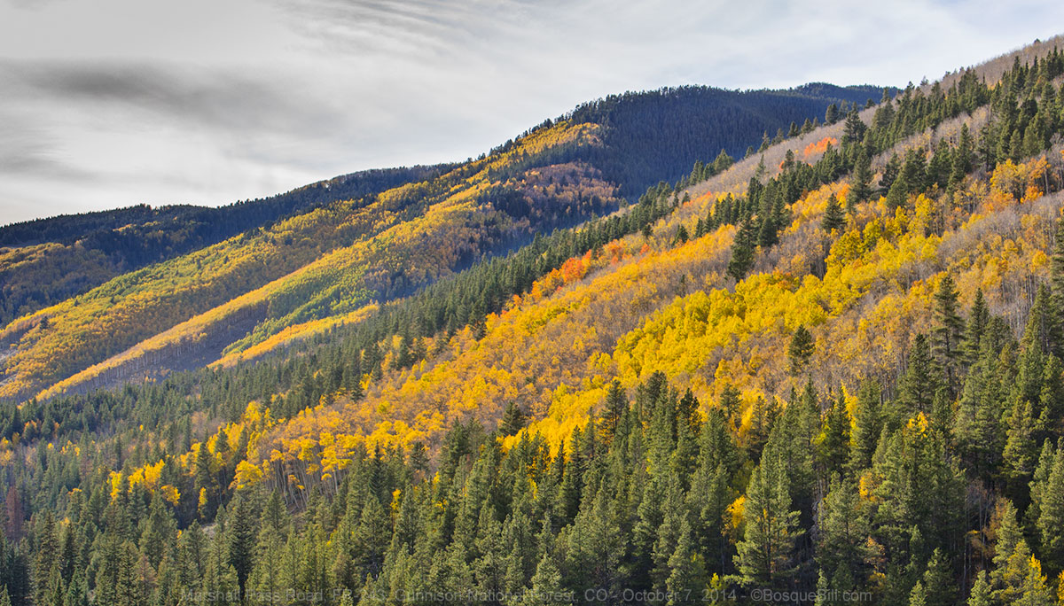
Colorful mountainside 

A patch of brilliant color captured using the telephoto lens.

I obviously like these photos of aspen leaves seen through the white tree trunks.

There were also more deer along here than I'd seen anywhere else on my trip. As the road continued to descend, I passed a few camping areas, but as they were right next to the road, I continued on. The road follows Marshall Creek and then entered into private land. I saw from my map there was a side road heading north, FR-242.2A and tried up that way for camping. There were a couple of nice sites, but they were occupied. There was another far off the road, but not particularly level or pretty, so I continued up the road. There was nothing else and then I hit the boundary line for the Pinnacle Mine, so I turned around and took the one open site I'd seen before. It wasn't as nice as the others I'd had on this trip, but it was getting late and I managed to find a portion of it that was close to level and without too many cow pies.

My campsite off a side road off Marshal Pass Road

Wednesday, October 8th


I still didn't know where I wanted to head from here. I understood that the weather was turning, so generally heading in the direction of home made sense. Marshall Pass Road comes out on US-50, so I could either head east from there to check out the aspen approaching Monarch Pass, then down 285 toward northern NM; or west to either turn south on CO-114 and hence NM: or continue on through Gunnison, then down CO-149 which would take me by Lake City, then south along the Rio Grande. I'd come up 149, named the Silver Thread Byway, earlier in the year and knew it to be a beautiful, scenic drive, plus I thought there might be aspen to view around Lake Cristobal above Lake City. This last idea won the day.

Lake Fork of the Gunnison


I drove through Gunnison, then south on CO-149. The first part of the route is through drier, lower terrain, then it goes up and over and down to along the canyon of the Lake Fork of the Gunnison River. There were some photo opportunities here, mostly cottonwood rather than aspen, but colorful. I noticed a side road dropping down into the canyon and turned around to explore that. It ran next to the river, right up against the canyon wall to the trailhead for Devil's Creek. There was an interesting truss bridge, but I didn't explore farther.

A scenic spot right along the Lake Fork of the Gunnison River near Devil's Creek

Truss bridge across the river just north of the previous photo.

As I was taking photos of the bridge and river I noticed the battery level indicator flashing on my camera. Oops, I hadn't been checking that and I could have easily recharged using my 12v/120v converter the night before. Well, I was almost to Lake City and it was lunchtime, so I would look for a cafe where I could plug in my charger while I had lunch.

Highway to Lake City with Carson Peak in the background

I found the Tic Tock Diner and the nice waitress found an outlet for me to use. I had a Tic Toc burger and by the time I was finished the battery was charged enough to get me through.

The road to Lake San Cristobal, County 30, is a few miles south of Lake City. This is the same road that goes to Cinnamon Pass (closed for the season.) Although slightly augmented by man, Lake San Cristobal was mostly formed by an ancient landslide that blocked off this fork of the Gunnison River.

I pulled in to the north end of the lake for photos. By this time it was between mostly cloudy and overcast, but still very pretty.

Lake San Cristobal and the gathering clouds

I then thought I'd head on up the road to look for more photos and this is where I ran into that adventure I promised.

Predicament


I passed the lake and the wide, dirt road continued along the river. At one point I saw a spot for a photo, but was past it before I could stop. I threw the truck in reverse to back up and get the shot, after checking there was no traffic. I was obviously not careful enough as I ran the two right-side wheels off the road. At that point there was a steep drop of three to four feet to the ground. I put the truck into 4WD and tried to drive out, but that caused me to actually slip father off. I put on the parking break and took a deep breath.

Just then a fellow and his wife came by and stopped in their John Deere ATV. The driver said "Looks like you're in a bit of a predicament." That was an accurate statement! I replied "Do you have any suggestions?" He said that if he'd been in a larger truck he could pull me out. I replied that I had a front hitch that would take a shackle, maybe that would help. His idea then was to pull from the side which might help keep my truck from sliding farther into the ditch. He was concerned that if we messed up my truck would tip over on its side, but I was hopeful this scheme would work. I dug out and installed the shackle mount on the front hitch and found the recovery strap which I'd also had the foresight to carry. We double-doubled up the strap so it would be short enough. He asked if I wanted to take a picture. If he hadn't brought it up I wouldn't have this evidence of my foolishness.

Not a good spot to be in, but at least I had recovery equipment and a good samaritan to help.

The plan was for him to keep tension on the front of my truck at an angle and help pull the front back on the road with the rear following as I eased out in 4WD. It took two failed attempts for me to remember I'd put on the parking brake - do'h. Once I disengaged the brake I was able to easily drive back on the road with the help of the ATV. Whew! Am I ever thankful I'd put on that front hitch earlier this year and bought those very basic recovery accessories. That easily saved me hundreds of dollars and the time and stress of getting a tow truck up there. And thankfully the event did no apparent damage to the tough little Tacoma.

I wasn't going to let that stop me, so took my photo, then drove on up the road for a while longer to see what was there. When I got to the point where clearly there would be no more autumn colors I turned around and drove back to the highway.

Upper Lake Fork of the Gunnison River

Slumgullion Pass – Spring Creek Pass


Continuing southeast on 149 most of the aspen were gone by. I again marveled at the enormous geographical area between Slumgullion Pass and Spring Creek Pass that is utterly decimated by the Spruce Beetle (Dendroctonus rufipennis). There were large groves of aspen in this area, too, whose branches were totally bare of leaves, though I was told later at the ranger station in Creede that the aspen are fine; they had just lost their leaves, probably from a recent wind storm.

The farther south you get from Spring Creek Pass, the less affected the spruce are by the beetles. There are some interesting side roads around the North Clear Creek Falls area, specifically FR-510, 509 and perhaps 532, as well. The views of Bristol Head Peak are magnificent. I do want to come back this way next year and spend a couple of days exploring this area.

Bristol Head seen from the Silver Thread Byway

Creede


I learned the name Bristol Head and about the Spruce Beetle at the ranger station in Creede. I had just driven on by this old mining town on my previous trip up 149 earlier in the year. I drove through downtown this time and saw for the first time the dramatic canyon just north of the village. I asked the nice lady at the station about that, too, and she told me about the scenic loop through the old mining area. She marked it on their vehicle use map, which she gave me, and said the Chamber of Commerce could provide more information ˗ See Bachelor Historic Tour on this page.

You may, or may not, recall that I live near the Rio Grande just outside Albuquerque. The river at home is wide and always muddy, and sometimes barely flows at all. So I enjoy seeing The Rio in its upstream incarnations. Beginning west of Creede, 149 follows the Rio Grande to its end (the route, not the river.) I didn't take photos of Wagon Wheel Gap, where the river and highway, squeeze between the canyon formed by Blue Park and McClelland Mountain, as the light was poor and my photo earlier in the year is still online (scroll down this page if you're interested.)

Palisade of the Rio Grande


Day-use area of Palisade Campground along the Rio Grande

The cliff along the edge of Blue Park is called the Palisade, and on my previous passage, late in the morning, I'd driven through Palisade National Forest campground which is between the highway and the river.

The Palisade for which the campground is named

It was a small, very pretty, wooded campground. I was fascinated that several sites were right next to the clear, rushing Rio Grande and thought at the time that it might be fun to camp there sometime. This would be that time. It was only 4pm, but I'd driven late the day before and if I passed this site there would be no others for many hours.

A campsite along the river, though I ended up choosing another site.

The Rio Grande River seen from my eventual campsite

My campsite seen from where I took the previous image.

There were no other campers, just one family having a picnic gathering, so I had my choice of sites. I chose one, walked around taking photos, them moved to another site with a better view of my river. I felt very lucky for several reasons: the campground was beautiful with views of the Palisades and many cottonwoods and willows in their autumn colors; the campground was indeed still open – it doesn't have a gate, and is low enough in altitude, that I suspect it remains open year around; there were no screaming kids or barking dogs; and as a bonus, the forest service had removed the cash box, so camping was free.

I love vanishing-point photos

An additional “feature” of the campground is a train track running through the middle of it. The first time I saw that I thought, yikes, but as it is only used for the Denver & Rio Grande Scenic Railroad between South Fork and Wagon Wheel Gap, I was not worried about noise. It runs Tuesday through Saturday, but only though October 5th.

An old boxcar used for storage and a maintenance car of some sort.

I was intrigued by the latch on the boxcar door - old school tech.

The tracks leave the campground, headed down river toward the station at South Fork.

I carry a small battery/crank-powered radio which includes the weather radio channels. Most of the time when I'm back in the mountains I cannot pick up a station. As the weather seemed to be closing in, I tried again this evening. I was able to pick up the station for the San Luis Valley to the east. The forecast was for rain tonight and tomorrow with snow at elevations and travel advisories for tomorrow night. So I put aside thoughts of camping in northern New Mexico and planed to head directly for home the next day.

Thursday, October 9th


I woke in the night to the sounds of rain. It was raining in the morning, too, and naturally that was when I ran out of propane in the bottle to which I was connected. The temperature was mild, so I wasn't worried about the furnace, but to be unable to make coffee, that would not do. I waited a few minutes for the rain to lighten up and slipped on my wind breaker, the closest thing I had to a raincoat, and stepped outside to swap the hose to the other bottle. That was the last break in the rain, so I wrapped my cameras up in plastic, gathered everything I needed to move to the cab, and prepared to get wet breaking camp.

Well, the thing about the aluminum camper roof is that it makes a light rain sound like a torrent. I was able to pack up, lower the roof, and hit the road without getting very wet. I knew though that I'd need to raise the camper top at home, when it was dry, to keep mold and mildew from forming on the sides.

South Fork – Homeward Bound


It rained all morning. I stopped briefly in South Fork, the end of the Silver Thread Byway, to take photos out the truck's window of the D&RG RR station to illustrate this blog.

Train station at South Fork

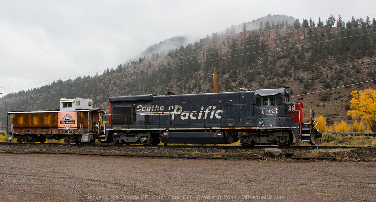
Engine and caboose parked next to the station.

It was still raining in Monte Vista. It was raining on and off by the time I reached Alamosa where I gassed up. It mostly stopped by the time I reached the village of Antonito, where I returned to the Dutch Mill cafe for an early lunch, a.k.a., breakfast.

It was overcast, but mostly dry as I continued south into New Mexico. I looked over to the west to the mountains where I had originally thought to continue camping and it looked like it was pouring down rain there. Turns out that Albuquerque had rain in the area, too, though it was pretty light. When I got home, the driveway was wet, but nothing was falling out of the clouds as I unpacked the truck and camper.

I think this was my most enjoyable camping trip of the year. The scenery was fantastic. The weather was great until the very end. I was lucky in finding good campsites. I had a little adventure that I escaped due to my foresight and even more luck. It's getting late in the season and with other unforeseen events, this might be my last trip for the year. If so, it was a good one. Thanks for coming along after the fact!

Autumn Color: Colorado Part 2

In Search of Autumn Color


Map showing the complete journey, all three parts of the narrative.

Part 2 of 3: October 4th to the 7th


After exploring the San Juan Mountains, Ohio Creek and Kebler Pass Road, I decided to head west to Grand Mesa. From there I would go northeast along the Colorado River, then southeast to visit Maroon Bells for the first time since my youth, cross Independence Pass, and... well, I didn't know where I'd go from there.

Saturday, October 4th (continued)


The west end of Kebler Pass Road terminates at CO-133. If one follows the highway north, it will cross McClure Pass and then drop down to Carbondale and finally come to CO-82, between Glenwood Springs and Aspen. I did want to go up that way, but first wanted to check out Grand Mesa National Forest, where I'd heard there were large stands of aspen. Instead of driving down through the arid areas on 133, where I'd been earlier in the season, I thought I'd go north a bit on 133 and then explore up FR-265, cutting though a bit of White River National Forest to reach Grand Mesa.

Buzzard Divide


Buzzard Divide Road where it begins to climb up into the aspen zone.

Buzzard Divide Road is the name my navigation app gave to FR-265, which is evocative, though I never did see Buzzard Divide or find it on a map or even see any buzzards. The road is tricky to follow at first as there are a number of junctions and road signs are scarce. Traffic was very scarce, too. The road winds through ranch country for a while and then begins to climb, though there is still open grazing. There were lots of aspen once the road gained some elevation and some great views.

A two-image panorama overlooking a beautiful valley with mountain peaks in the background.

I took a short spur at Muddy Flats to find a grassy meadow to stop and have lunch, and learned there is an oil well up that road – I'm glad I was there on a Sunday.

Returning to the “main” route and continuing on I began to see a few hunter campsites, but the area remained lightly used. I crossed from White River NF to Grand Mesa NF, though still was not on Grand Mesa proper. The terrain opened back up into ranch country. There were a couple of junctions and route changes to place me on CO-330 on the route to the town Cullbran. There was also more evidence of oil or gas wells. I lost most of the elevation gain by the time I reached Cullbran.

I wasn't sure which road I wanted to take to get up onto Grand Mesa, so stopped at the gas station/c-store on the highway at Cullbran for advice and directions. The young woman said I could either continue on the highway to the “desert” then take the main road up, or I could go through town via dirt roads into the mountains. I elected the later course, though I had to stop for directions again before I got out of town as the route is unmarked with lots of turns, and the initial instructions I received were less than clear.

Grand Mesa


Once the road began climbing up toward Grand Mesa there were a few aspen changing color, but not very many. Once on top, it was impossible to know one was on a mesa top, as it was all firs and spruce, streams and lakes, and a winding dirt road between the hills. It is a very nice area, however, I saw no aspen up there of any color. I drove south, then west on FR-121 passing many campgrounds, lakes, and side roads where dispersed camping appears to be available.

One of the many lakes on Grand Mesa

I drove all the way to the Visitor Center at the junction with the aforementioned highway, CO-62. The VC was not only closed, but completely empty; at least the restroom was open. I had hoped to ask a ranger where the heck all the aspen were that I'd been told were on Grand Mesa. I did ask a fellow visitor who was gazing at a map and he said there were lots of aspen just down the hill toward Delta on 62.

I headed down 62 and after a few miles there were indeed lots of aspen. There were also amazing views off the drop-off side of the mesa toward Delta and Montrose. However, with the haze and sun, I took no photos. The highway winds all the way down to the dry, arid area below and I didn't really want to do that. What I wanted was to find more aspen and a nice place to camp.

My campsite nestled among the aspen.

I noticed on the map a small road with lots of switch-backs that seemed to be in about the right area to climb up the mesa side through the large aspen grove. I found this road, which turned out to be Old Grand Mesa Road, and it did indeed meander up though acres of aspen. I found a short turn off at one of the curves near the top that led to a dispersed campsite. I set up there and walked around before evening set in. I followed a game trail for a while and heard water. Following the sound I came to a small spring; it was a delight to find, but sadly not photogenic. There was an ancient, for aspen, tree near my campsite. Someone had put up a sign to commemorate the tree, but I forgot to read it.

An amazing mother aspen nearby my campsite.

Sunday, October 5th


After breaking camp, I drove the short ways to the top of Grand Mesa, past a few small lakes and back to CO-62. This time I turned north on the highway toward I-70. As the highway began to drop off the mesa top, there was an enormous aspen field. Unfortunately, they had all lost their leaves.

A highway overlook at the edge of Grand Mesa. Most of the aspen here have lost their leaves.
Note the view of arid canyon lands in the distance wherein runs the Colorado River.

A bit lower and I began to see some aspen still with leaves and there were a couple of places to pull off and admire amazing views.

Aspen along the highway crossing the lower shoulder of Grand Mesa

Lower and lower I drove until I was out of the forest and into the very dramatic, steep canyon of Plateau Creek. After several miles of winding curves the highway came out at the freeway.

I turned northeast on I-70 and had to remember how to drive at speed. My intention was to turn off the freeway at Glenwood Springs toward Aspen and Independence Pass. It had been over 40 years since I'd seen the beauty of Maroon Bells and I hoped I'd be able to see that this trip. The freeway here runs along the Colorado River, which makes it a bit more scenic than in other stretches.

Glenwood Springs is an interesting place, a combination of tourist attraction and small town funk, like many towns in this part of the state. I stopped at the 19th Street Diner along the main drag, CO-82 to Aspen. It was lunch time, but I had a hankering for breakfast. I ordered eggs with sausage patties, hash browns, and toast and it was delicious.

Maroon Bells


I called my buddy Chris to let him know I was still in pursuit of autumn aspen and that I was on my way to Maroon Bells. He mentioned that due to the popularity of the site, visitors had to park just outside of town and ride shuttle buses into the area. This was news to me, not having done my research beforehand, but I soldiered on. I had seen the entrance gate to this special fee area on the map, and had also noticed there were a couple of campgrounds past the gate on the way to Maroon Lake. My new plan was to ask at the entrance if there were campsites available and if so, did that allow me to drive to the lake.

Sievers Mountain (I believe) which is on the "other" side of Maroon Lake.

Turns out there were and it did. Excellent. I was assigned a lovely spot at the Silver Queen campground, where I attached my permit to the post. I then drove up to the lake to take photos. The light wasn't perfect, but it is indeed a gorgeous spot. I then drove back down the paved road, stopping as the mood hit me and the afternoon light hit the hillside and those aspen that were still showing color. It was all fabulously beautiful in the late afternoon sun.

The aspen along here were mostly green or yellow

Maroon Creek

Spent a pleasant evening in the quiet campground, only about 4 of the ~8 sites were taken. I had a very nice conversation with the couple with a camping trailer “next door.”

My campsite, #2 at Silver Queen NFS Campground

Monday, October 6th


It was another 27Āŗ morning and in the shade of the campsite it didn't warm quickly, so I took my time before breaking camp. I drove up to Maroon Lake. It turns out the shuttle busses run every day in summer, but only Friday - Sunday after Labor Day. Since this was Monday, the parking lot was already full when I got there at 10:15. I was directed to the lead position of a long RV parking slot by a ranger.

Maroon Bells reflected in Maroon Lake

Maroon Bells was gorgeous with the sun brightly shining on the peaks and the snow aligning with the rock strata. Breathtaking!

My friendly campground neighbor the night before had recommended the hike to Crater Lake, so I set out. This is a steep, rocky hike – definitely not a walk. I had a bottle of water and too much camera gear, though I was wearing my good hiking boots. About 2/3rds of the way to the lake I realized I should have packed a lunch as the climb was taking much longer than I'd estimated. The round trip was supposed to be just less that 4 miles. I stopped and dug into my camera bag hoping I'd left an energy bar in there somewhere. I was rewarded with a Cliff bar that was only slightly old and hard.

This chickadee was so close to me that I had to cut off his tail.

There was a rocky area to cross before getting to Crater Lake. It looked like some sort of upheaval to me as it seemed too far from the mountain walls to be an avalanche spoil. I heard a “cheap” and spotted a Pika on a big rock. I took several photos, but it was much farther away than the one I saw at Ophir Pass in July. Turns out there were lots of Pika in that rocky area which made me happy to note.

American Pika, one of many seen along the trail in the high rocky areas

By the time I made it to Crater Lake the weather was changing. The fleece jacket I'd removed on my way up the mountain helped to cut the wind. High clouds were starting to move in and the wind on the water kept the lake from reflecting the mountain peaks. It is a magnificent place, too big even for my widest wide-angle lens.

Crater Lake and Maroon Bells

The hike back was less enjoyable due to my low energy state; it had been way too many hours since breakfast. I had to keep reminding myself to pick my feet up and not kick the rocks. At least it was mostly downhill in this direction, as one of my fellow travelers had remarked.

Cute chipmunk seen along the trail

A view of Maroon Lake looking down from the Crater Lake trail.

On my drive out, before I left the forest, I stopped to picnic and enjoy the last views of the beautiful canyon vista. In Aspen I stopped at the ranger station for advice on camping for that night. It turns out all the campgrounds in the Aspen Ranger District had closed on September 15th, except those at Maroon Bells. Apparently that's when the contracts with the concessionaires completes. In these modern times the NFS contracts for campground hosts and maintenance most places. I asked about the status of campgrounds on the other side of Independence Pass, but he didn't know as that was a different district. The ranger told me that there were dispersed campsites along Lincoln Creek Road on this side of the pass, so I thought I'd try there. I restocked perishables at City Market before leaving Aspen.

Independence Pass


Again, it had been over forty years since I'd been on this road and hadn't recalled just how narrow the highway is as it climbs toward the pass. I understand the prohibition on long vehicles, now. I was very scenic, however.

I found the turn-off to Lincoln Creek Road. The ranger mentioned it was a bit rough, but that some folks had been in there the previous week with their Subaru with no trouble, though they had to drive slowly. I passed the (closed) campground I'd visited all those years ago. My only memory of the place was that it had been mid-July and my dog's water bowl froze solid during the night. The road was terrible, covered with nasty pot-holes. 5 m.p.h. would be way too fast on that “road.” The sign said there were 22 campsites in the first 6 miles. The first two were occupied, the next ones were nowhere near level enough for a camper. The canyon was narrow, steep and dark, not at all inviting. After two miles I retreated, slowly, got back to the highway and headed toward the pass.

A backlit aspen grove along the highway up to Independence Pass

Obligatory photo of the sign at the pass

My backup plan was to explore Forest Road 391, about five miles beyond Independence Pass and I was guessing that any of the campgrounds would be closed. I found the turn-off to the road on the south side of the highway. There was a sign announcing that the first 1.6 miles of the road was on private land, no trespassing. The road was rough, but not nearly as bad as Lincoln Creek. It follows the South Fork of Lake Creek and not far from the highway is the trailhead for La Plata Peak, one of Colorado's fourteeners.

South Fork of Lake Creek with La Plata Peak in the background, a fourteener.

After about a mile, the road enters a wider valley and is quite lovely. I found a nice camping spot just after the 1.6 miles, according to my odometer, but thought I'd explore just a little farther along. After a bit I came to the sign I was entering San Isabel National Forest, which was closer to two miles from the highway by my reckoning. Nonetheless, within fifty feet was an even better campsite near the creek, under some tall trees, so I backed in to claim it as my own.

My campsite along South Fork Lake Creek Road

This squirrel wasn't real pleased that I camped in his territory, but he allowed me to stay.

All this time I'd seen no sign of anyone else on the road, but as I maneuvered my truck level, I saw a couple walking down the road toward me. As they got near I said “hello” and asked if they were camping up the road. No, they'd started out to climb La Plata, but never saw the sign for the trailhead. Oh, well, they said that they had a nice walk; they were parked in the lot by the highway. After they continued on, my only companions were the Gray Jays and the squirrel.

Tuesday, October 7th


During the hour or so it took me to break fast and gather myself to pack up, two separate pickup trucks drove past and on up the road. Hunters? Fishermen? Don't know. After breaking camp, I continued up South Fork Lake Creek Road until I came to the junction with FR-381. This is about half as far as the road goes, according to my map, and it forks again farther along. It was interesting to me, too, as the peaks I was seeing ahead were the far sides of those Collegiate Peaks I'd admired and photographed when I was at Taylor Park, earlier this summer. There didn't seem to be any autumn color up that way, however.

South Fork Lake Creek Road (a uncharacteristically smooth stretch) south of my campsite.

Twin Lakes - Leadville


I returned to the highway and set off east toward Twin Lakes. As I passed the campgrounds I'd seen on my maps, they were indeed closed. There wasn't much activity at Twin Lakes and the visitor center was closed – another summer destination, I guess. There was not much in the way of aspen, either, though I took a couple of photos.

Twin Lakes

When I reached US-24, just past Twin Lakes, I decided to detour north to Leadville as another place I hadn't seen in over 40 years and to visit the ranger station there for a map and information. I stopped for lunch at the Golden Burro Cafe in Leadville. It was not bad, but really not too much to recommend it other than being about the only restaurant open in town.

I had to ask directions to the ranger station, as it had moved to a new facility at the south edge of town. I'd obviously driven by it without noticing. I bought the map for San Isabel National Forest and enquired about various side roads south along US-24 and the prospect for autumn color. I left with ideas, but no set plan.

This concludes Part 2 of this 3 part journey.

In Search of Autumn Color: Colorado

A Narrative in 3 Parts

Colorado, October 2 – 9, 2014


My plan was to head up to SW Colorado on the last Monday in September to look for colorful, fall aspen leaves, but the weather forecast was not good, so I delayed leaving until Thursday.
This turned out to be an excellent decision, as the skies were clear when I arrived in Colorado and there was still photogenic snow at the higher elevations (and some mud and slush, too.) I enjoyed great weather most of the trip, though it got cold at night.

I took lots of photos during this trip, so thought breaking up the narrative and images into three parts made sense for you and for me.

Remember to click on a photo to open them all at a larger size in a viewer window.


Here's my route for the full week, very roughly clockwise in travel - follow the red arrows and colorful legend.

Part 1: October 2nd to the 4th


The first part of my journey took me up though the San Juan Mountains to Owl Creek Pass. From there I headed northwest, passing though Gunnison, to follow a county road along Ohio Creek up to Kebler Pass Road.

Thursday, October 2nd


As I headed northwest through New Mexico, the truck experienced some head winds left over from the storm passing, but luckily they died down after about an hour. I stopped for lunch at Zia Tacqueria in Durango. As I mentioned in earlier blog posts, my neighbors had raved about their fish tacos, which I had indeed found to be delicious. This time I thought I'd try their green chile pork - yummy!

There was some autumn color as I drove into the San Juan Mountains. My destination was Owl Creek Pass. My buddy, Chris, had strongly recommended the area for autumn color. He had shown me his beautiful photos with Chimney Rock, and other interesting formations, as backdrop. As I drove through Silverton I saw that the aspen were far past peak, so I didn't bother checking up Mineral Creek, but continued on.

Approaching Engineer Mountain on US-550. Autumn color is beginning to show.

Owl Creek Pass


I passed through Ouray and Ridgway to turn east on Owl Creek Pass Road on a beautiful, late fall afternoon. I could see Chimney Rock way off to the east. After driving up a wide valley, the route began to climb into the mountains and the road changed from dry & dusty to rocky, and then muddy with patches of snow in those areas that receive lots of shade.

Chimney Rock

Many of the aspen groves were gone by, brown or even leafless, but most were others still green or shifting into yellow. I stopped to take pictures from time to time. The late afternoon light was lovely on Chimney Rock. I drove over the pass and down the other side with the intention of finding a dispersed campsite.

Cold, snowy Owl Creek Pass

I skipped the first road just below the pass, FR-860, as it was too snow covered. This eastern side of the mountain seemed to have more snow, though there were clear stretches, too. As I drove down the mountain I could see colorful aspen west across the valley, but as they were in the shade, I decided to come back this way in the morning.

I checked out one campsite just before the Cimarron River. It was ok, not too muddy, but cold and uninviting. I passed Middle Fork Road, then turned up the East Fork Road. There were folks camped along there and those sites unoccupied were muddy or snow covered. When the road climbed away from the river, I backtracked to Middle Fork Rd. The first site was taken, but the second was not only open, but level and scenic, alongside the river. It was a little muddy, but the ground was at least firm. I set up in the last light of the day with rapidly falling temperatures. (I need to come up with a better mud control protocol for setting up to keep the floor of the camper dry and clean. Perhaps a plastic carpet runner cut to size would do the trick.)

My campsite along the Middle Fork of the Cimarron River with the last rays of sun on the peaks.

Friday, October 3rd


My campsite in the frosty morning

I took a short walk around the area where I'd camped, though the temperature was still cold. It had gotten down to 27Āŗ overnight. It was a nice area and there were a couple of other large dispersed sites just a little farther up the road. After my walk, I drove to the end of Middle Fork Road where there is a trailhead. There was one side road to explore another time, but no other campsites. I turned around at the trailhead.

I then drove back up Owl Creek Pass Road to look at the areas I'd seen the evening before. Such a beautiful area. I also saw the same unpredictable mix of green, yellow, brown and bare aspen groves, many times right next to each other.

FR-860 near Owl Creek Pass

I drove up the road just below the pass in hopes of photographing Chimney Rock from the "morning" side with aspen in the foreground. There were no aspen up this road. I did, however, see my very first moose in the flesh and tried to get a picture as he disappeared into the trees. I turned around where the road goes from unimproved to 4WD only. It was very rocky and my goal this trip was for autumn color, not rough roads.

My very first moose sighting, somewhat out of focus. I was delighted to see this guy!

I took another look at the pass itself, then drove back down. I took a number of photos in the area where FR-858, 861 and 863 converge south of Silver Jack reservoir, though those roads may be numbered differently on different maps. There are many dispersed campsites in these areas.

Owl Creek Pass Road down near the Cimarron River

I then headed north on 858, a.k.a, Big Cimarron Road, named after the river.

At the junction of Owl Creek Pass Road and East Fork Road

Roadside glory

The reservoir and campground was closed, but there were some pretty aspen by the closed, Beaver Lake campground with a little pond farther north - and a gaggle of photographers.

Pond next to Beaver Lake Campground

Such a beautiful scene. I had to include another view.

I decided to continue north along Big Cimarron Road to US-50 rather than staying in the area. As I drove down the road, I passed a number of trucks pulling long, trailers. I bet they were headed for those wide, flat campsites I'd just vacated. Big Cimarron campground was still open, but then the national forest ended in private land.

Ohio Pass


Ranch country along Ohio Creek Road on the way to Ohio Pass in the Anthracite Range.

On reaching US-50, I drove east to Gunnison, then turned north on CO-135. Just a few miles north of town is Ohio Pass Road, to the left, which goes through quite a bit of ranch country, then climbs toward Kebler Pass Road. There were a few photo opportunities along there.

Looking southwest at the West Elk Mountains from near Ohio Pass.

Once I got to Kebler Pass Road, County 12, I took a look at Lake Irwin campground, which I'd missed my last time by here as the road is unmarked. This time I was forewarned, examined the map carefully and found it. A nice forest campground with a pretty lake, but I had aspen on my mind, so moved on.

Lake Irwin, with the campground overlooking the lake. Photo taken crossing the small dam.

Kebler Pass


I headed west, over Kebler Pass, on CO-12. There were a few aspen photo opps and lots of people admiring them. I checked a couple dispersed camping areas, but they were well populated. I didn't want to go too far as I figured the light would be better in the morning for the area I was traveling through. Then I spotted a little, muddy track into an aspen grove with a nice campsite. I set up there in the late afternoon and walked around taking pictures while the light lasted. Luckily the ground in the grove itself wasn't too muddy. It was covered with aspen leaves of all colors.

My campsite in an aspen grove, not far from Anthracite Creek.

A photo using my 300mm lens showing an outcrop of The Dike formation.

Ruby Peak as seen though my 100mm lens.

Saturday, October 4th


I backtracked a few miles to photograph one of the scenes I'd passed last evening.

Anthracite Creek with Ohio Peak in the background.

I continued west on Kebler Pass Road. I enjoyed the scenery much more than my last time when it had been raining and overcast. I took the spur, FR-706, to Lost Lake Campground. I'd hadn't explored that way last time. Another small, pretty campground with a dramatic view of high mountain peaks reflected in the lake. I had a nice chat with a fellow in a VW Westfalia. There were a couple of dispersed sites along the road to the lake close to the main road.

Lost Lake on a glorious morning.

Continuing west on CO-12 there were some spectacular vistas looking across the patchwork color laid upon Snowshoe Mesa with snow covered mountains in the distance. As beautiful as this was to view in person, the photographs were too pedestrian to include here. Hwy 12 drops elevation here and runs along Anthracite Creek (which I later figured out, was the same water as I'd photographed earlier) until it and the creek reach the North Fork of the Gunnison River at CO-133.

The journey continues in the next installment.