Saturday, September 14, 2013

Northern New Mexico, featuring Carson National Forest - Part 2


Wednesday, August 28, 2013 (continued)

If you're following along from yesterday's post, we've just crossed the Rio Grande Gorge Bridge west of Taos. A map of the entire journey is at the top of the previous post.

US-64 turns north after crossing the bridge and passes an unusual housing "development." This is The Greater World Earthship Community of radically sustainable buildings - and some of the biotecture is certainly way out and whimsical. I didn't stop or take pictures, but it might be interesting on a future trip.

There is a large plateau between Taos and Tres Piedras that is interesting for those of us who love wide open spaces. On this trip the long mountain vistas were enhanced by the carpet of wildflowers lining the road. 

Straight shot toward Tres Piedras - a scene not untypical for New Mexico.

In March of this year, the president designated five new National Monuments and this area was one. There are nice photos on the website linked below.

Río Grande del Norte National Monument in New Mexico. Located northwest of Taos, the Río Grande del Norte contains stretches of the Río Grande Gorge and extinct volcanoes that rise from the Taos Plateau. The area is known for its spectacular landscapes and recreational opportunities – like rafting, fishing and hiking – and serves as important habitat for many birds and wildlife. The monument is also home to a dense collection of petroglyphs and extraordinary archaeological and cultural resources dating from the Archaic Period to the more recent passage of Hispanic settlers.  The monument will be managed by the Department of the Interior’s Bureau of Land Management, which currently manages the more than 240,000 acres of the monument.
-- from the BLM website.
After crossing the plateau, I stopped at the ranger station at Tres Piedras for information on routes or closures in this district of the Carson National Forest. I asked about a couple of roads I'd seen on the map, but the young man there recommended I head north on US-285 for about 10 miles, then take NF-87 to the northwest, following it to 87A and then north to Rio de los Piños for camping.

NF-87 runs northwest, south of San Antonio Mountain - one of the aforementioned extinct volcanoes - though a lovely high plateau of grasses, sage and wildflowers. 

On NF-87 looking back toward the east whence I came.

The road then surprisingly dips down into a verdant valley with the Rio San Antonio running through a meadow-like setting. 

The road descends into a small valley of Stewart Meadow.

Rio San Antonio riparian area

Once the road climbs out of that small valley it does indeed begin to climb. Up it goes, providing glorious views back toward the Taos Plateau and the volcanoes, then up into a majestic Ponderosa forest, then continues up into the spruces and miles of aspen groves as it skirts Banco Julian peak.

The road forks at the rim of the Cruces Wilderness Basin with 87 continuing southwest to Lagunitas, which the ranger said got rough, and 87A heading north. I headed north, as recommended, and noted a couple of dispersed campsites along the rim that had gorgeous views across the basin - the sunsets there would be amazing, I'm sure. I was tempted to camp there, but as it was still early I pushed on.

Overlooking the Cruces Basin Wilderness

The road then begins to drop rapidly and for long stretches is extremely rocky. Not impassible rocky, but about as bumpy a road as I've been on - made me wonder just how rough the Lagunitas Road was to merit mention by the ranger. After several miles as the road dropped and continued to be rocky, I wondered if I'd made a mistake pushing on. Lower and lower it went with the temperature climbing and few if any dispersed camping areas. I was about to despair that I'd been steered wrong by the ranger when I caught a glimpse of the canyon below with a small lake or river reflecting the blue sky.

I came down into a grass covered valley with the Rio de los Piños running briskly along. There was a wooden bridge, then the road T's. To the right is a graded road and eventually civilization. To the left is a narrow, uneven road with a warning concerning wet weather… and a spectacular canyon - the lower end of the Toltec Gorge!

Rio de los Piños

I chose the canyon and mentally thanked the ranger who recommended I come here. The river is wide (for a New Mexico trout stream) rushing along over the rocks; the canyon walls push straight up from the far side of the river leaving patches of meadow between groves of evergreen trees. The road would indeed be a nightmare if truly wet, as it was there were larges patches of mud and puddles, some quite large and deep. When confronted with one monster, I backed out and camped at a beautiful meadow right next to the river with a view of those amazing canyon walls.


It was a delightful evening. I enjoyed sitting outside on my lawn listening to the river gurgle and watching a couple of Belted Kingfishers call and chase each other around. I kept the screen door on the camper closed thinking the mosquitoes would be out soon, but luckily none spoiled the show.


Thursday, August 29, 2013

After breakfast I decided to drive up the canyon. The evening before I'd seen a couple of fishermen drive up then later come back down, so the road was probably passible. It looked like the monster mud hole should be tackled head on and I successfully did so. The canyon continued to be lovely. It would widen out a bit and there'd be a nice dispersed camping site, then it would narrow down and there was barely enough room for the road. A few places were muddy and some of the rocks and holes required slow speeds, but nothing was truly challenging for a standard high-clearance truck.

A smooth, dry stretch of NF-284 along the Rio de los Piños

The road, NF-284, continues up into Colorado according to the map, but the ranger said the road got bad as it went on. From the map it looked like it hit private land then climbed up out of the canyon, so when I got to a scenic point I got out of the truck and admired the view for a while before turning around. Perhaps earlier in the year, before the seasonal rains, this would be an interesting road to explore. On the way back down the road I met a young man who was camping nearby and he recommended a forest road in Colorado, off Hwy 17, for scenic camping. He didn't know the name or number, but described the junction very well.

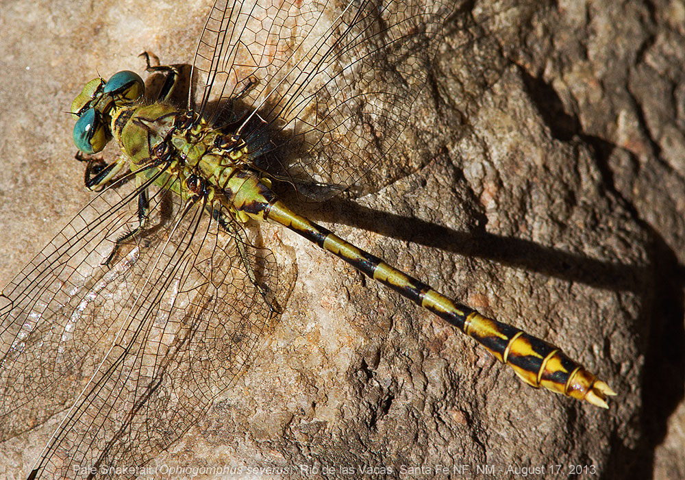
On the way down the canyon I stopped a couple of times to check for dragonflies, but other than a few darners it must have been too late in the season. After passing the bridge at NF-87A I'd crossed the day before, the canyon walls disappear and there is private land labelled as the village of San Miguel. Past there the valley is wide and the road and river pass through a NM State Recreation Area named after the river. There are several small informal camping areas, which were poorly maintained, and a number of people fishing. From there agriculture takes over and before too long the dirt road is paved and crosses north into Colorado where it is as straight as a ruler and named "Road 12.5".

The road arrives in the town of Antonito at a confusing intersection near the terminal station of the Combres and Toltec Narrow Gauge Railroad. It was getting on to lunch time, so looked for a cafe for a hot meal. I drove completely through town and saw several liquor stores and an old downtown hotel, but only one eatery, The Dutch Mill Tavern & Cafe in the small downtown section of town. There was a convenient parking space on the street nearby. I had my doubts when I entered as there was only one person at one table though it was nearly noon and no sign of wait staff.

I needn't have worried (by the time I finished the cafe was full of locals enjoying lunch.) The menu was a combination of home cooking and mexican food. I didn't know if this would be New Mexico style cuisine being this close to the NM border, but they did spell chile correctly and offered red & green, so it would probably be OK. I decided to order their "famous" open-faced chili burger. I ordered it with red & green chile, aka "xmas", and with fries rather than mashed potatoes (?).

OMG, when the plate arrived it was covered with a huge mound of food. The burger was indeed open faced and the fries were placed on the other half of the bun and the whole thing was drenched in chile sauce. As I shoveled it down I could envision my arteries clogging as I sat - actually I exaggerate, even though it was probably a few thousand calories, it wasn't greasy.

As I was paying my bill I noticed a hand lettered sign on a paper place mat taped to the wall: "Homemade Strawberry Rhubarb Jelly $5". On the spur of the moment, even though I was stuffed, I asked for a jar. Actually, it wasn't jelly at all, but rather jam or preserves and rather than draw things out, when I tried it later that evening, it was incredibly delicious! Sadly, it is long gone as I write this post.

I asked for directions to Hwy 17 as I was turned around and, as I hadn't planned on coming to Colorado, I didn't have my good maps. Heading west it wasn't long before entering the Rio Grande National Forest and the road began to climb up into Ponderosa pine country following the course of the Conejos River. Beautiful country, but also lots of dude/hunting ranches and private homes.

I found the road the fellow I'd met recommended. It is NF-250 and entered a beautiful valley surrounded by tall mountains. However, the scenery could not compete with the horrible washboard of the compacted gravel road. I'm guessing this is an aspect of decreased national forest budgets caused by the sequestration - no money to grade roads. If I needed to drive the road or really knew if it was worth it I could have aired down my tires. As it was I turned around and headed back to the highway.

Climbing out of the valley on the newly resurfaced asphalt was a dream, especially with the great views. Here's a photo looking back up the valley where I'd turned around and it does look gorgeous. I may have to explore it on another trip and hope the road has been graded in the meantime.

Conejos River Valley, Colorado

The highway turns south and travels though La Mango Pass at 10,230 feet and Pinorealosa Mountain following the scenic railroad line in many places. This part of the national forest may be a good area to explore later, too. The highway continues south, exits the national forest, and returns to New Mexico after passing through tiny Cumbres.

As I was getting near Chama, I recalled that this is the southern terminus and location of the headquarters of the Cumbres & Toltec Scenic Railroad. When I passed the station and yard, just north of town, I turned around and parked to walk around and photograph the buildings, engines and equipment. The train itself was off on its travels, apparently, so I'd content myself with what might be there.

Engine 487

Station and Ticket Office

Switch Engine

Rotary Snow Plow (steps & platform not original equipment!)

Water and Coaling Towers

Denver & Rio Grande Western rolling stock

I picked up a brochure from the ticket agent so I can plan to ride the historic train on its scenic route another time.

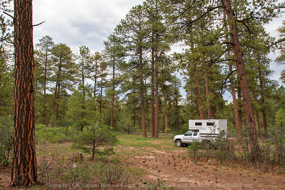
I proceeded south on US-84 from Chama. As it was Thursday before the Labor Day holiday, I figured I'd camp one more night in the southwest corner of Carson NF before heading home. This was an area with which I was totally unfamiliar, so I stopped at the Canjilon District ranger station to ask about road conditions and camping.

I was informed that NF-137 from Canjilon to Las Placitas passed through piñon/juniper habitat at lower elevations, and would be fairly warm, I asked for suggestions for something at higher elevations. I was told the area around Canjilon Lakes was very nice, but probably already getting busy due to the holiday. Trout Lakes was also a good place, but the road was very difficult when wet, and since thunderstorms were expected to move through the area, that was probably out.

The lady at the station recommended that I loop up into the aspen of the high country on NF-124 and tipped me off that the road sign at the junction on the main road to the lakes had been stolen and not yet replaced, so to keep an eye out for the turn just after entering the national forest boundary.

I found the road and drove up the mountain. Dispersed campsites were not prevalent at all and the few I saw were far from level enough. Plus, the aspen in this area did not look very healthy and lots of cattle were grazing in this area, too. Not the most attractive area. I went up and started back down, then found an interesting spot. It was not much more than a parking space, at right angles to the road, between some tall trees, but it was right at the edge of an escarpment, so there was a spot to place my chair for a wonderful view across the basin to the northwest.

I spent some time leveling the camper and started on the preliminaries needed to camp. I was slightly concerned that this spot seemed to be a drainage area and if there was a heavy rain it would run right under and around my truck. I had also been noticing more and more bees buzzing around, in fact I realized there were lots of bees and they were flying in the truck when the door opened and would likely get into the camper, too. Those two factors caused me to abandon that campsite and continue down the mountain.

I drove all the way down to the junction with NF-125, a couple of miles in from the main highway, without finding a single passible campsite. I didn't want to go very far up 125 as I could see evidence that it would indeed get bad when wet, and the skies were already darkening and there were rumbles of thunder. I finally found a camping area about halfway to the highway with ground that looked like it wouldn't turn to gumbo in the first rain.

"Emergency" campsite

It was a little closer to the road than I would have preferred and was a bit on the well-worn side, but it was either that or head back home and end up driving late into the night as I didn't know of any camping between there and home. That night as the thunderstorm chased me into the camper and the rain went on and on, I wondered if I'd made the right decision. 

I remembered that I'd actually received a phone call from a friend while I was setting up camp and noticed at the time I had a good connection for data, as well. So, I opened my Wundermap app and checked the RADAR. I was relieved to see most of the storms were well to the south and the rainy area near me would soon pass away. That put my anxiety to rest and I was able to get a good night's sleep.


Friday, August 31, 2013

The morning dawned clear and bright. I had the satisfaction that I'd chosen my "emergency" campsite well, as the ground was wet, but not soggy. I traveled the short distance to US-84 and set off to the south with the goal to be home by early afternoon.

There were open vistas of tree covered hills and as red rock cliffs came into view I wished I'd left my camera set up for a few quick shots through the windshield. That reminded me that Echo Amphitheater was along here somewhere. I'd last been to it when I was still in high school when the youth group I was with stopped here for a picnic lunch on our way farther north for a camping trip. But like my last high school trip to Carlsbad Caverns, I was more interested in the cute girls on the trip than the natural beauty of the landscape - so didn't remember much about it. Plus, that was a lot of years ago.

There it was. Cool. I turned in for a couple of quick pictures, but as I drove up into the parking lot it looked interesting enough for me to pay the very modest fee and walk around.


The piñon and juniper provided an attractive contrast to tall sandstone cliffs in shades of cream and red. The sky was an incredibly deep blue. The chamisa and sunflowers were blooming. It was gorgeous and I took photos like crazy as I walked around, then up to the amphitheater itself.

Looking south along the cliff line toward the Jemez Mountains.

The paved trail up to the base of the amphitheater. Yes, you can hear your echo up there.

As I'd driven into the park area, I'd noticed they had a small campground which I hadn't realized was here. I drove the loop through the ten modest campsites on my way out, wishing I'd known about it the day before as it was much prettier than my previous night's camp. I'll remember next time.

Back on the highway, headed home. I soon reached the familiar area from my previous Jemez Loop trip, just a few weeks before. Though this time, after filling the gas tank in Española, I drove straight home. 

A wonderful journey around northern New Mexico with a short "detour" in Colorado. Thanks for joining me. See you next time!


Friday, September 13, 2013

Northern New Mexico, featuring Carson National Forest - Part One

This was only a four day trip, but I've broken it into two parts to make it a bit more digestible. Recall that you may click on a photo to open a larger version in the viewer. Below is a map of the complete journey.


I traveled this route counter clockwise. Red pins - my campsites.


August 26, 2013

I had intended this trip to be dragonfly hunting in the Gila NF, but a last minute status report from two traveling Odonata experts from Texas informed me that the Gila and Membres Rivers were running high and dirty due to run-off from a wildfire scar burned earlier this year - terrible conditions for finding odonates. I was psyched up for a trip, so came up with a quick alternate plan. My new plan was to first check the river in the Rio Grande Gorge, then to head up into the national forest, explore the area around Tres Ritos, then play it by ear. 

I got a timely start on Monday morning, fought my way through the morning commute, and headed north on I-25. It was cloudy and hazy, unusual for New Mexico, so I crossed my fingers for good weather. I drove around Santa Fe on the bypass and took NM-68 at Española toward Taos. The skies were clearing as I drove up along the rio. I stopped at the County Line River Access site where river rafters usually conclude their voyage. At only a little past 10, it was quiet and I waded into the shallows. I found an American Rubyspot damselfly and a Sooty Dancer damselfly, but that's all. Still, it was a pretty place with picnic tables and toilets.

I drove on, passing the junction to Dixon that I'd return to shortly. I made the left turn at NM-570 into the gorge proper where the main highway to Taos climbs away from the river. I'd never been this way before. There are a few homes amid the cottonwoods, then I entered U.S. Bureau of Land Management land. I had the misconception this area would be barren and rocky. Yes, the canyon walls are volcanic rock, but there is a lovely riparian area along the river. 

Looking at the Rio Grande in the gorge near the old bridge.
I drove up to the old bridge, passing a number of nice campgrounds. FYI, there appears to be no dispersed camping in the gorge. I checked around the boat (raft) ramp, but found no odes. I'd printed out a satellite map where a friend had found some interesting species about a half mile up the old dirt road along a small tributary. I parked where the road is blocked; it's a hiking and mountain biking trail now. It was very difficult to get to the stream, and impossible to walk along it, as the water flows between very large boulders in a steep, narrow slot with heavy vegetation. I was photographing a few flirtatious damsels when I discovered I was standing on an ant hill! They were crawling all over my sandaled feet and ankles, so I did the "I'm standing on an ant hill dance!" I was luckier than I deserve. These were not biting ants. Whew! 

I climbed back up to the trail and walked along it. It would have been very difficult to get to the stream and maybe even a bit dangerous for an old fat man with lousy knees, so I would check the banks with my binoculars. Had I seen a dragon flying I might have risked the steep climb down the boulders, but I didn't, so I didn't. 

I stopped and checked a few other spots as I drove out of the gorge, but found no dragonflies. I pointed the truck south at the highway to turn east on NM-75 at Dixon. I stopped at the district ranger station in Peñasco to check if there were any closures or flooding to watch out for. The report was all clear. 

Before I left the parking lot I checked my map and saw a overlook marked only a couple of miles out of my way and as I was past due for lunch turned left at the junction of NM-518 to check it out as an impromptu picnic. To my unexpected delight this was the exact view that had impressed me when I passed this way in 1973. The intervening years had enhanced the view, but it was still a wonderful vista. Unfortunately the overlook itself was mared with graffiti and trash. Sigh. 

Looking toward Taos from the scenic overlook on NM-518.
I reversed course and headed toward Tres Ritos on 518. I checked the lovely trout stream named Rios de Pueblo in a few places for odes without success other than the natural beauty of the flowers, trees, babbling waters, and rock outcrops of the canyon walls - no complaints in that regard. 

Cliffs along the Rio de Pueblo.

I turned north on NF-76 just passed the little village of Tres Ritos. The graded dirt road heads up La Junta Canyon along which flows the Rito la Presa. 

Rito la Presa
There are two campgrounds and many campsites in the first 4 &1/2 miles. These are not considered dispersed sites, so fees apply. On the plus side, the fee is small and the forest service controls vehicle access in the camping areas resulting in prettier sites with more grass than those farther up the road. This is the area to choose if pitching a tent.

La Junta Canyon - camping and river to the right of the road.

Beyond the gate at mile 5, dispersed camping begins and this is where I settled after first exploring farther up the road. Up the road I spotted a couple of grouse along the road. I was just able to take this photo by shooting out my truck window.

Dusky Grouse (formerly the Dusky varient of the Blue Grouse.)
The canyon has obviously seen heavy use over the years, especially by ATV riders, so many areas along the river, beyond that 5 mile gate, have lost their grass and are compacted dirt and ruts.It is a shame they've turned so much beauty along the river into a racetrack. (However, if you want to park your camper next to the creek, then accept the conditions.)

Campsite along the creek.
I hadn't thought much about it, but apparently every night I'd camped this year had a bright moon. This night was totally dark and the stars were amazing, though my view was restricted by the tall trees around camp. I was wishing now I'd brought my spotting scope. It was nice listening to the creek running as I fell asleep. 

Tuesday, August 27, 2013

It was 41 degrees when I woke up and it took a while before the sun reached down into the canyon. Once it did, I got out my camera and enjoyed photographing the flowers, butterflies and scenery in camp and along the road as I took a short walk. I hung out there long enough to see if there were any odonates along the creek; there were not.

La Presa creek and mountain daisies 
The colorful side of the Hoary Comma butterfly on Sneezeweed.
The same butterfly with its wings closed - what great camouflage for tree bark or leaf litter!
Cute little guy let me share the campsite with him.
I realize not everyone is as fond of creepy bugs as I, but really can't you see how cool he is?
Ever since I'd noticed that Mora was less than 30 miles away, I'd been salivating over the memory of the wonderful blue-corn, brisket enchiladas I had on my inaugural camping trip early last spring. I decided to adjust my itinerary so I could get back there for lunch. It would also be a good place to top up the gas tank. It was a beautiful drive to Mora and with very dramatic views coming down the backside of the mountain. 

Rene's 50's Diner is not the first name that might come to mind for quality New Mexican cuisine, but the enchiladas were every bit as good as last time and the sopapillas were excellent, too! Highly recommended. I got to meet Rene this time as he came out of the kitchen to meet and greet his customers. Super nice guy. Played football for SMU in the Class of 1962. 

While I was in the neighborhood I drove the 10 miles to Morphy Lake State Park to check it out and to see if there were any dragonflies. It is a pleasant campground but the lake is very, vey low. There were a zillion damselflies, but only a couple of blue darners. The road is not suitable for long trailers or large RVs.

A view back toward the Pecos Mountains from a valley south of Mora from my Morphy Lake jaunt.
An alpaca ranch just north of Mora.
I returned to Mora then drove up NM-434 toward Coyote Creek State Park, as I thought the creek might be a good place for dragonflies. I didn't see anything at a quick glance in the park, so declined to stay and pay. What I hadn't noticed on my earlier trip is that there are a few fishing easements just north of the park. I stopped at the first one and did find a Pale Snaketail dragonfly along with Paddle-tailed Darners and a Springwater Dancer damselfly, plus a cool Sphinx Moth.

Coyote Creek

Paddle-tailed Darner dragonfly

Pale Snaketail dragonfly

Sphinx Moth
When I had enough playing in the creek I continued up the paved road - it is too narrow and crooked to really call it a highway along that stretch. It winds through timber at first, then opens to high meadows. 

View of Taos Mountains from NM-434
I thought to drive up to the north end of NF-76, where it comes out south of Angel Fire, then go up the road to look for camping sites. The road was fine at first, but then degenerated to extremely rocky with deep ruts. I kept on for a while looking for dispersed camping, but the few spots I did find were not at all level. 

I gave up and checked the maps. NF-5 just off US-64 west of Angel Fire looked promising (as long as it didn't turn into another rocky obstacle course, I thought.) I drove back down the mountain, then back north through Angel Fire, then west on US-64. NF-5 is a short way west of the pass. When I turned onto the road I was happy to see it had been recently graded. I drove up it about a mile and found a lovely, level meadow just off the road and set up camp there as the sun dropped below the ridge.

Campsite along NF-5 
Another pitch black night with amazingly bright stars and the Milky Way overhead. The trees and canyon cut off my view close to the horizon, so I wasn't able to find any of the constellations that I've always been able to quickly spot. I was surprised how disconcerting that was. I'd never realized how comforting it was to be able to pick out at least a couple constellations in the night sky.

Wednesday, August 28, 2013

It was a beautiful morning and it was great to see all the green grass and trees around me. I drove the couple of miles farther up the road just to check it out and found additional dispersed camping sites. A good place for dispersed camping in the Eagle Nest/Taos area. 

I returned to US-64 and retraced my steps west, then continued on north. I thought I'd see if Cowboy's Corner in Eagle Nest would still be serving breakfast by the time I got there. They do "until 10am or so" so I was in luck. Got one of the scrambles and what a huge plate of food it was! I believe I mentioned this little cafe on the post of my very first trip with the camper when I had an excellent green-chile cheeseburger. In talking to the owner, Frank, he said things were very slow in Eagle Nest for all the businesses. For whatever reason they just didn't get the usual tourists from Texas this year. He thought I might have to do with the economy; I speculated that all the wildfires in NM early in the season might have prompted the vacationers to set their plans for elsewhere. I put about half my scramble in a go-box to heat up for a full meal later.

I left Eagle Nest on NM-38 headed toward Red River. An interesting drive that I don't think I've ever made. Just before Red River I turned south on NM-578 which runs along a pretty trout stream. I didn't go far, but it looked interesting. Past Red River I stopped at Fawn Lakes to check out the dragonflies, but there weren't too many.

I hadn't realized there were mines near Red River until I saw the tailings reaching as high as a mountain. Seems there are molybdenum mines and mills there that have been worked for almost a hundred years.

I turned south at Questa on NM-522 toward Taos, then back west on US-64 just before town. This route takes one across the Rio Grande Gorge Bridge. These two photos are from my crossing last fall when I drove up to Denver to get my first look at an actual FWC camper.

Rio Grande Gorge Bridge

Looking north from the bridge at the Rio Grande
I crossed the Rio Grande as soon as I left my house, followed it north for the first half day before driving east and looping back around to it. I think this second crossing is a good place to break my tale in two. The next installment will follow shortly. Thanks for reading.

End of Part One

Tuesday, August 20, 2013

Jemez Mountain Loop

[Remember, you can click on a photo to see a larger version. You can even move from photo to photo to enjoy the views and the flowers and cute critters while avoiding my tedious verbiage.]

I had time for a short trip, so thought I'd zip up to the western half of the Jemez Mountains of New Mexico which are only about 60 miles north of Albuquerque. [Jemez is pronounced, "HAY-miss" with just a slight 'z' sibilant in the 's' sound.]

I wanted to check for dragonflies, revisit old haunts, and to also explore some of the areas I'd not been to before. I figured my 4x4 truck and camper would be ideal. I used my Benchmark Recreation Atlas before I left to rough out my journey, being careful to avoid areas that I knew were damaged due to flooding caused by excessive runoff from recent forest fires. My map covered some of the National Forest roads, but not all, so I planned on stopping at the Walatowa Visitor Center for Jemez Pueblo before leaving the highway, as they have a National Forest Information center where I planned to buy a detailed map of the forest and its myriad back roads.

I figured I'd drive up through the Gilman Tunnels following the one forest road with which I was familiar, up a pretty valley with a clear trout stream. I'd then stop at the Seven Springs Fish Hatchery, as it usually had lots of dragonflies. Then I wanted to revisit San Gregorio Lake where my dad and I used to camp and fish. I guess I was last there when I was about 14. From there, I had no plans, but would just explore and see what I could find.

Here is a map of the route I ended up driving:

Jemez Mountain Loop - August 2013


Thursday, August 8, 2013

I started a day later than originally planned to avoid a large storm headed toward my destination. There were still a few clouds, and naturally I had a headwind, but otherwise a great day to be on the road and headed for the mountains. After making the turn at San Ysidro from US-550 to NM-4 and passing through Jemez Pueblo I stopped at the Visitor Center. There I had my first bad luck of the day, they were out of maps. So I studied the one they had framed on the wall to supplement what I'd already learned from my map and from looking at the satellite Google map.

Rio Guadalupe before entering the canyon
I turned on NM-485 to pass through the tiny hamlet of Gilman. I first travelled this road back in the early 1960's. At that time it was a private logging road which they opened on Sundays and it was one-way north to south. It was a thrill to go through the two short tunnels that had been bored through solid rock. It is now National Forest road 376 open in both directions. It is popular for picnics, for fly fishing in the Special Trout Waters, and in the autumn for colorful aspen groves. There is also dispersed camping allowed for much of its length.

Looking back at the tunnel after passing through. Rio Guadalupe Box Canyon.
I headed north, stopping just past the tunnels to check the Rio Guadalupe for dragonflies. I found American Rubyspot damselflies, a few other as yet unidentified damselflies, and a cool spider.

American Rubyspot damselfly.

Thin-legged Wolf Spider with egg case beside the river.

Continuing north, even without the detailed map, I managed to find the turn-off I wanted which would take me to the Rio de las Vacas. I drove north on NF-539 to a delightful spot right next to the creek. 
Rio de las Vacas

 A Pale Snaketail dragonfly landed at my feet.

A Spiny Tachina Fly and a Flower Crab Spider on a Sneezeweed blossom.

A pretty blue Pleasing Fungus Beetle

There were Pale Snaketail dragonflies here as well as blue darners. Later on examining my photos I discovered I'd managed to photograph a new species for me, a Shadow Darner. I had lunch in this scenic spot.
Shadow Darner dragonfly.

I returned to NF-376 to proceed north. I stopped at a fishing access to again check for dragonflies. The stream was interesting here as it was confined to a narrow serpentine channel though deep grass surrounded by trees and shrubs. I was tracking a darner and started to cross a foot bridge so I'd have better light for a photo on the other side.

As I was walking across, the plank underfoot tilted. Next thing I knew I was falling into the creek. Instinctually, I tossed my camera onto the far bank as I fell. I managed to catch myself without a complete dunking, but was a bit shaken (and later learned I was a bit bruised and battered.) My wallet stayed above water, too, thankfully. As I pulled myself out I was worried about my camera and telephoto lens… and where was my hat? I was greatly relieved to determine that my camera seemed to work. The integrated/retractible lens hood was now oval, not round. I pushed it into a more circular shape, but it no longer seemed to retract. I thought it best not to try a field repair. I spotted my straw hat half submerged under a log down stream.

After retrieving my hat I looked down and there was an enormous snake right at my feet - well, it looked enormous to me! It wasn't moving, probably lying in wait for lunch to wander by. It was really quite pretty with broad, glossy black and brown bands, but I'm not really a fan of snakes. Don't bother me and I won't bother you, is my philosophy. As I slowly backed away I realized I could see neither head nor tail in the deep grass, so didn't know which end to avoid. However, it never moved and I escaped.

Upon returning to my truck I continued to drive north along the forest road. I have to say that I'd never seen the forest look so green and healthy. After years of drought apparently a few weeks of monsoon rains restored all the plants. The grass was green and the evergreens and aspen were flourishing. I bet the autumn colors will be great this year. Unfortunately for you, dear reader, I neglected to take general landscape photos of this area.

There are lots of dispersed camping areas along here, but the day was still young. I turned left on NM-126 toward Fenton Lake SP. I passed that by to get to the Seven Springs Fish Hatchery a few miles farther north. The ponds there had provided lots of good dragonflies and damselflies in years past. To shorten the tale, there were no dragonflies and darn few damselflies there. I drove on up the creek another mile or so on NF-314 to where the road is blocked off and the former campground is day-use only. There was no activity in the creek there, either.

So, back to NM-126 to head to San Gregorio Lake. The state highway is only paved to the turn off to the fish hatchery. The middle section is gravel and "native surface," i.e., dirt. Nonetheless, it is a scenic drive up a canyon and onto high meadows.

Once I turned off NM-126 onto NF-70, following the sign to San Gregorio Lake and the San Pedro Wilderness, nothing looked familiar. As if I'd recognize it after all these years. Still, I didn't figure out the trailhead for the wilderness was where one parks to hike to the lake - there was no signage to that effect. Consequently, I drove a number of miles past that spot before it began to dawn on me. It was a nice drive, in any case, and I backtracked a couple of miles to find a nice, level camping spot. I went to sleep listening to the elk call and the cattle low. Did I mention that much of the national forest land is used for cattle grazing?

Campsite (phone photo)


Friday, August 9, 2013

After breakfast I drove the couple of miles back to the wilderness trailhead. I had cleverly built a sandwich to take along in my camera back before I lowered the camper roof, together with an apple juice pouch and additional water I set off for the lake. The trail to the lake was totally unfamiliar, too. Later I figured out that it was indeed a different route than that my dad and I took years ago, once I saw the old trail from the lake. I guess they moved the parking and trail at some point in the intervening years.

About halfway to the lake I started to see some small damselflies on the ground along the trail. By the time I reached the lake there must have been hundreds. Curiously, since there were so many, I neglected to take more than a couple of photos, which made identification later a bit tricky.

Boreal Blue - immature

The lake was fairly low with only a couple of people fishing near the earthen dam. San Gregorio is actually a reservoir, not a natural lake. There were lots of ground squirrels and chipmunks living among the rocks along the dam surface.

Least Chipmunk - the cutest of the cute critters.
There were a few dragonflies hunting back and forth along the shore and I attempted to photograph them when they'd hover. Later I found a species that would land and pose for a photo - much easier.

Four-spotted Skimmer

Golden-mantled Ground Squirrel give me the "business."
I spent a couple of hours walking the lake taking pictures of odonates, chipmunks, ground squirrels, and flowers, and having my lunch with a great view. 

Wild Geranium

Spotted Sandpiper along the lake shore (non-breeding plumage - no spots.)

Stripped Meadowhawk

Woolly Cinqfoil

I'd left my landscape lens in the truck, so used my phone to take this photo of the lake.

San Gregorio Lake (phone photo)

I walked through a moist area below the dam where there was a small seepage creek. There I found a bunch of darner dragonflies both hunting and mating. Lots of opportunity for photos here.

Paddle-tailed Darner

Common Water Strider
With a storm on the horizon and the sound of thunder, I headed back to the truck. I was happy to have finally revisited the lake and had the chance to take lots of photos.

From the parking lot I headed back to NM-126 as I'd found a Santa Fe National Forest Pocket Guide among the maps I did succeed in bringing along and it showed that NF-103 was a through route to NM-96 which crosses west to east on the north side of the mountains.

I stopped a few times at creeks and a small retention pond to look for dragonflies, but didn't have much luck with dragonflies, but saw these damselflies doing the deed.

Boreal Bluet damselflies in copula
I saw a bear! My first wild sighting, though far from a close encounter. I was driving and as I came around a curve in the road, I enjoyed the view of the east end of a westbound bear. He had obviously heard me first and was really moving. He disappeared into some small bushes in a shallow draw. I slowed down with my camera ready, but he never poked his head up for me.

Once I got to the paved highway I headed east with intentions to stop at the Coyote District Ranger Station and finally get my National Forest map. I did indeed achieve this lofty goal and also got a recommendation to try the Rio Chama to look for dragonflies and advice on where I could find dispersed camping for the night. They also provided me with a Motor Vehicle Use Map which shows all the approved dispersed camping areas in the western half of the national forest.

It was nearly 4:30pm by the time I left the ranger station, so planned to camp first and go on to the Chama river in the morning. The ranger had warned me that NF-100 had some washboard and he wasn't just a whistling "Dixie." It climbed up through some rugged, dry hills with interesting geology. 

Interesting geology and Cerro Pedernal along NF-100 (phone photo)

In case I hadn't mentioned it, the whole of the Jemez Mountains was built by a large ancient volcano. When I was growing up it was considered the largest volcanic caldera in the U.S. at over 12 miles across - that was before anyone realized that in fact the whole of Yellowstone was one gigantic, enormous volcanic caldera in which Valles Grande, as it was named then, would be just a speck. It is now the Valles Caldera National Preserve.

Once the road climbed  up into the timber zone it cooled off rapidly and became verdant. I should have taken photos of the wide, shallow valleys covered in green grass with a border of pines and evergreens, but I was just too busy sightseeing, I guess.

When I got up around ten thousand feet in elevation I spooked a herd of around 20 elk. The herd was all cows and calves. They were not happy to see me. I did manage to grab a few shots with my long lens out the truck window. I'm guessing these are of the Rocky Mountain subspecies.
Elk calf and cow

After exploring the mountain roads for a while, I decided to backtrack to a large meadow I'd passed earlier that appeared to be in an approved camping zone. The meadow had the most magnificent Ponderosa Pines and was a gorgeous place to camp. It also had the benefit of being several miles from any of the herds of grazing cattle in the area.

Campsite along NF-100 - no crowds of tourists here, no one, but me.


Saturday, August 10, 2013

It was lovely to wake in this green meadow with the grand trees. I filled my travel mug with hot coffee and drove down the mountain, enjoying the changing scenery in reverse.

Ponderosa Pines

After only a few miles east on NM-96 I came to Lake Abiquiu. On impulse I drove down the backside of the rock covered, earthen dam to check the Chama River below the power house. It was running pretty fast, so I didn't expect many odes, but in fact found none. I talked to a number of folks fishing. They hadn't seen any dragonflies and not any fish either. One said there were many dragonflies at the lake itself.

I checked out the campground at Lake Abiquiu, which like the lake, is run by the Corps of Engineers. It seemed to be very popular with a nice view of the lake, though it was above and a ways back from the water - on reflection that probably keeps the bugs away.

I drove over to the boat ramp to check for odes, but only saw one - a common Variegated Meadowhawk. So on to my next destination.

Chama River Canyon Wilderness
The Rio Chama above the lake is a Wild & Scenic River preserve administered jointly by the National Forest Service and the Bureau of Land Management. There are two sections, if you will. The upper section starts below El Vado Lake and flows through a narrow canyon. Access is only by water and a permit is required to launch a raft. The lower section which I visited, is accessible via NF-151 from US-84. The road is about 13 miles long and ends at a Monastery. There are places to launch and retrieve rafts, day use sites and campgrounds. Rafters my camp along the river in designated areas.

Rio Chama and rafters.
I'd never been along here before and it was indeed scenic. Deep red puddles on the side roads gave evidence of heavy thunderstorms the previous day. I briefly occupied a free campsite to check out the river for dragonflies (there were none) and to have lunch at the picnic table. I checked the river at a couple of other spots for odonates with a similar lack of success.

I left in the early afternoon once it clouded up and storms began to move in. I traveled back south on US-84 to the small city of Española along the Rio Grande where I got gas. Having seen all the green heathy forest in the western and northern parts of the Jemez, I felt strong enough to drive up the east side, which had been devastated by the Los Conchas fire of two years ago.

I drove up the opposite end of NM-4 on which I'd been on Thursday. This stretch bypasses Los Alamos, the Atomic City, and Bandelier National Monument. The monument has been affected by bad flooding due to loss of ground cover caused by the forest fires. Only certain sections are again open to the public and access is only by shuttle bus from White City.

The east side of the Jemez is much, much dryer than the west side - I'm guessing it's the "rain shadow" effect. There are stands of pines totally dead, not just brown. This has to be due to the excessive drought that has affected the region for a number of years.

The burnt areas are very sad. A few areas apparently experienced only a lower intensity fire and in those aspen and other vegetation has started to come back, though it will be many years before pines and other evergreen trees will achieve any height.

Many areas must have experienced a high intensity burn, hot enough to kill roots and soil bacteria. Those areas show little recovery. And there are a few in between which have not tree activity, but annuals, such as wildflowers are flourishing due to increased sunlight, I'm thinking.

A number of my favorite areas, such as along NF-289, where I used to go birding and simply enjoy the scenery are gone and won't recover in my lifetime. Very sad.

As I drive farther west and then south the affects of the fires become less, but still evident, and the affects of flash flooding become more apparent as evidenced by the high water mark of debris along stream channels and draws. Many day use and fishing access points along the Rio San Antonio and Jemez Rivers remain closed due to flood damage or the risk of additional flash floods. 

I passed through the village of Jemez Springs and closed the loop where I'd turned west on NM-485 on Thursday. An uneventful drive back home completed this enjoyable short escape.

Thanks for reading.