Part 4 of 4 - Continued from Part 3.
Canyon of the Ancients National Monument
The section immediately below is out of sequence in order to make this blog post self-contained for those who are looking for information on Canyon of the Ancients National Monument in Colorado's Four Corners region.
Remember to click on any image for a larger version (recommended.)
May 17, 2018 (continued)
I drove back to the highway, CR-10, after visiting the outlying units of Hovenweep National Monument, and turned right toward the northeast. It wasn't long before I was in an agricultural area, leaving the piñons and junipers behind. As soon as you cross into Colorado you are entering Canyons of the Ancients National Monument, administered by the Bureau of Land Management. If you look at an official map, you will have visions of vast, empty open spaces. Had I not looked at the Google satellite view while planning the trip, I might have been shocked. All the relatively flat areas in the national monument are forage farms complete with giant storage sheds and farmers and workers homes.
Dispersed camping is allowed in the national monument, but not near the archeological sites or on private property, not unexpectedly. I'm suspect there are nice spots scattered around, but not many. The official brochure directs campers to the Bradfield Recreation Area campground east of Pleasant View (described in
Part 3.)
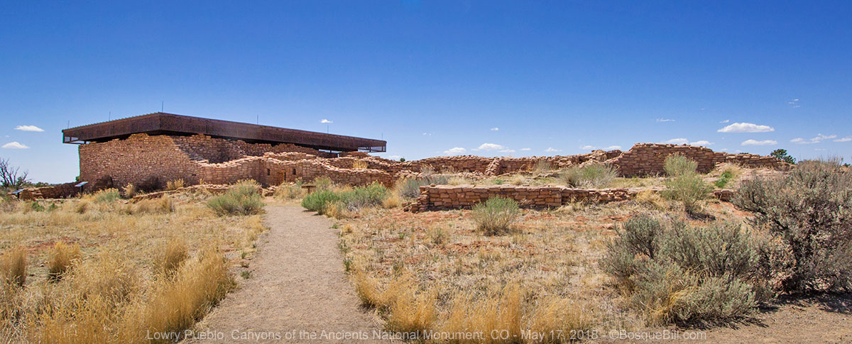
Lowry Pueblo
I followed CR-10 to CR-CC where I turned left (west). If you are coming via US-491 look for CR-CC. There were directional signs for Lowry Pueblo, my destination. When I pulled into the parking area there were a couple of young men intent on their phones or something. Usually folks will glance up when you pass right next to them, but not these guys. When I got out I heard buzzing, but not very loud. They were flying a drone. I was curious, so went over to talk to them. They were from Kansas, if I remember right, and were traveling to Salt Lake City, stopping to video ancient ruins from the sky. They were flying a Mavic Pro - pretty cool. I chatted with them about it after it landed, as I've been curious if I wanted to add this device to my photo/video tools for exploring and the blog. After looking into it a bit once home, I've decided drones of the quality, and quietness, I'd want are priced a bit higher than petty cash.

A protective roof structure has been erected over Lowry Pueblo, as you can see from the photos. I assume they wouldn't go to that expense unless there were significant archeological items to protect, but it does distract from the ruins themselves.
 |
| The main path from the parking lot. |
 |
| A close view of the main wall of the pueblo. This is very much in the style of the great houses in Chaco Canyon. It uses found stone and not shaped stone as I'd just seen at Hovenweep National Monument. |
 |
You can duck under a couple of low doorways to see this interior kiva.
There are steel screens to keep the curious out of this area. |
 |
| The main structure as seen from the south side (I think.) |
 |
| Pueblo walls next to the main structure. |
 |
| Looking back at the pueblo walls with the ruins of a round room in the foreground. |
 |
| This great kiva is about a hundred feet from the pueblo. |
If you are following along chronologically then you'd jump to
Part 3 at this point. Otherwise keep reading.
May 19, 2018 (continued)
After visiting the Bradfield Recreation Area and that section of Dolores Canyon (See
Part 3) I returned to the bridge and at US-491 again turned south.
Anasazi Heritage Center
At CO-184 I turned east and drove about seven miles to the BLM Canyons of the Ancients
Anasazi Heritage Center. This would be my first visit. I pulled into the parking lot of an attractive modern building, with a style reminiscent of an ancient pueblo, and past a large solar array.
I had read online that the center was placed here as there were ruins on-site. After parking I decided to visit the ruins first. I followed the paved trail that climbed the hill behind the center. There were small signs identifying plants and trees along the way, as well as, larger signs pointing out landmarks and conveying a bit of history. At the very top of the hill was a great view of McPhee Reservoir of the Dolores River and the Escalante Pueblo ruins.
 |
| View of McPhee Reservoir of the Dolores River from atop the hill. |
 |
| Turning to the right you can see the San Juan Mountains. |
 |
| Information sign. |
 |
| Escalenta Pueblo was not large, but what a vantage point they had. |
I was surprised and delighted that one of the signs in addition to pointing out Sleeping Ute Mountain, and Abajo Peak behind Monticello, also pointed out the Bears Ears just poking above the horizon. I thought it was so cool that my entire week's journey in Utah and Colorado was essentially within sight.
 |
| Sleeping Ute Mountain |
 |
| To see Bears Ears you will need to look at the horizon above the larger building at left. Click for larger image. |
At the bottom of the hill, as I was walking toward the Center, there were more ruins between the building and the parking lot. These were walls for a small unit called Dominguez Pueblo, though perhaps, as they conjecture only one family lived here, it should be called a house, not a pueblo.
 |
| Information sign. |
 |
| Dominguez Pueblo |
There were planting beds surrounding the circular brick plaza in front of the Center. The plants were very small, I guess spring comes late here, and each little plot had a small sign for what was expected to grow. There was also an interesting ceramic sculpture of a Mountain Lion decorated with ancient symbology.
 |
| Entrance to the Center. |
 |
| Mountain Lion sculpture with Sleeping Ute Mountain in the background. |
Inside I was greeted by a friendly BLM Interpretive Ranger. We spoke for a little while, a little about the Center and surrounding national monument, but also about my trip and especially Dolores Canyon. He agreed the canyon was a little known treasure. I asked what kind of oak trees I saw all along the river. He didn't remember clearly, but believed them to be Gamble oak. I remarked that all the Gamble oak I'd known in New Mexico were shrubs. He allowed that in the right circumstances and with plenty of water they could grow quite high. When asked about rafting and visitation, he was the one who told me about the high flow last year and the low flow this year, and that when the river was low flow very few people visited the canyon.
I moved on to the collection which was very interesting. It is along the same lines as Edge of the Cedars State Park in Blanding, Utah, though not as extensive. I felt my time was limited as I wanted to be home by a reasonable hour that evening. Consequently, I took lots of photos and tried to absorb what I could from a relatively quick walk-though anticipating returning for a more leisurely perusal on another trip.
 |
| Banner as you enter the collection. |
I present these photos, without captions, in the hopes you see something that peaks your curiosity enough to put the Anasazi Heritage Center on your list of places to visit. There were a number of exhibits that I did not photograph.
 |
| They had recreated what's believed to be a typical ancient living space. |
 |
| Looking across the collection from near the edge of the living space exhibit. |
 |
| A view of the entrance plaza as I left the building. |
 |
| One more look at the cool cat. I didn't see any info on the artist. |
Leaving the Center I turned left on the highway, then south on CO-145 to Cortez. I stopped for lunch there (though not at a place worth recommending), then back south on US-491 to Shiprock, NM and home.
Thanks for reading my blog. I hope you found something interesting, or informative, or fun.


Interesting, informative, and fun! What a pleasant meander through beautiful country! Thanks for documenting your trip and letting us tag along.
ReplyDeleteThanks for taking the time to put together this trip report. I'll refer to it when I plan my next trip to the area.
ReplyDeleteNice work again, Bill. Because of this I finally got around to trying some night shots of the Milky Way, but have to get back home to the main computer to give them treatment. I did get an interval meter after seeing what you did, haven't used it yet other than as a remote release. Up in the Cariboo again helping the same friend with cancer convert the RV shelter into a cozy cabin this summer.
ReplyDeleteThanks, Len. I bet you could get some lovely time-lapse shots of the aurora up there with the intervalometer. Use the Google to find articles on camera settings, etc. and let me know how it goes.
Delete