Showing posts with label Scotch Creek. Show all posts

Friday, October 8, 2021

San Juan Mountains, CO - Sept 2021: Part 1

September 20 - 25, 2021


My goal after my last trip was to install a second 100W solar panel on the camper roof, then test it out on a trip after Labor Day - in the hopes there would be fewer folks competing for camping when the kids were back in school. Weather pushed it a week further along. I wasn't going to worry about it being early for autumn color, either. I thought I'd go up into the western portions of the San Juan Mountains of Colorado to both familiar and new locations.


Part 1 of 3

Monday, September 20th


I got a good start in the morning. And headed up NM-528 to US-550 north. I was delighted to discover the Chamisa (aka Rabbitbrush) along the highway, all across the Colorado Plateau, was in full bloom. I remembered it blooming the first weeks of October, so it seemed early to me this year. I took my usual "bypass" on the BIA routes to avoid the Bloomfield-Farmington-Shiprock traffic and then up US-491 to Cortez where I re-fueled. 


Scotch Creek

I drove north on CO-145 hoping to find a favorite campsite on Scotch Creek available. I first stumbled upon the site the first year I had my camper (post) and stayed there again a couple years later (post).

It is just under a quarter-mile off the highway, up a narrow rocky trail. It is far enough up the canyon, though, that you rarely hear traffic along the state highway. With an ATV, or such, you theoretically can drive all the way over the mountain to US-550 near Purgatory Ski Area. Usually only a few vehicles pass along the road which is so rocky and bumpy that they go slowly and kick up no dust.

Campsite in the late afternoon sun. You can see the stump of the tree that used to precariously lean over the campsite.

Last time I camped there I was slightly concerned about a couple tall evergreens that leaned over the site somewhat precariously. Since then they were removed making the site a little sunnier (good for the solar panels) and a bit safer. The wildflowers were not blooming this time of year and only a few aspen had the slightest tinge of yellow. The wild rose hips were brilliant red and shiny. It may not be the most beautiful spot ever, but the creek keeps up its end of the conversation and the narrow canyon walls are interesting.


Tuesday, September 21st

Scotch Creek (continued)

I decided to stay another night in this tranquil site. It was 27º in the morning so I didn't rush outside, but sat in the warm camper drinking coffee and reading an interesting novel I was mid-way through. Once it warmed up a bit, I walked along the road enjoying the scenery. A downside for longterm camping is that there are no trails to explore, so you're confined to the rocky road. But I was able to keep myself entertained.

Here are two photos showing the signs at the entrance off the highway.


My campsite in better light.

An aerial view looking up the canyon (east.)

An aerial view of my campsite.

Rocky road.

Up the canyon a short ways.


Wednesday, September 22nd - Autumnal Equinox

Scotch Creek (continued)

A repeat of the previous cold morning. I packed up and drove out late morning. I headed up the highway toward Rico and Telluride. I stopped along the highway before Rico, though, as I saw a marshy area next to the Dolores River that looked like it might have dragonflies. I did find Black Meadowhowks and Northern (or perhaps Boreal) Bluet damselflies.

Looking across the marsh next to the Dolores River south of Rico.

Black Meadowhawk dragonfly


Bolam Pass Road

When I'd done my "research" for this trip, I'd noticed a road north of Rico that went up a canyon toward Bolam Pass, CR-578. I'd never been that way, so thought I'd check it out for scenery and dispersed campsites. The road ran along (mostly above) Barlow Creek. 

There were nice views and the road was good gravel for the first 2-3/4 miles. Once it crossed the creek, however, it became one of those narrow San Juan Mountains rocky trails that are uncomfortable to drive in a highway vehicle. I turned around once I determined it unlikely to unveil any campsites anytime soon.

This is as far up the canyon as I drove. The road was extremely rocky and no fun to drive.

I returned to the creek crossing (a culvert) and parked at a nice spot for lunch. This was the one good-looking dispersed site on the road. The lower part next to the creek was not at all level, but there was a somewhat level place to park your camper or pitch your tent back in the trees. As it was on the north slope it wouldn't get enough sun for my solar panels, but might be very pleasant for others or as a single night stop-over. I should have taken a photo, but it didn't occur to me at the time.

I found this butterfly after I had lunch.

Some of the small aspen groves were beginning to turn, so I took a few photos on my way back to the highway. I'll only show you one, as they all turned out to be only a slightly different perspective of the same view.

On my way back to the highway I stopped for this photo.

I turned north, again, with my mind's eye on Alta Lakes. I'd seen the Alta Lakes turn-off south of Telluride, near the Sunshine Campground, but never had heard anything about it or explored there. It wasn't until after I did my mining town video tour a couple years ago that I was researching for that post that I discovered there a ghost town there. The map also showed there was a "dispersed campground" at the lakes. This was my destination. 

I stopped briefly at Trout Lake as a few groves were starting to turn and the mountains always make for a dramatic background.

Make sure you click the photo to see a larger version. I stitched together multiple exposures to create this panorama of the lake and mountains. Taken from the shoulder of the highway.

A gorgeous morning to be out on the lake - what a beautiful scene.

Back on the highway. Next stop is Alta Lakes and whatever that my bring!


Continued in Part 2

Sunday, July 19, 2015

San Juan Mountains, CO - June 2015 - Part 2

June 24th to 27th


I wanted to escape the heat of central New Mexico and head for the cool mountains of Colorado. My idea was spend a few days in the southwest portion of the San Juan Mountains exploring the area around the West Dolores River where I never been. I didn't intend to stay long, just a few days, not even through the weekend. This was a quick decision as I realized the following week would be part of the July 4th holiday get-away for lots of others, and I wanted to avoid those crowds.

Remember to click on a photo to view at a larger size.


Part 2


Friday, June 26


A chilly morning. It was much colder at this elevation (around 10K), abetted by the affect of the ice cold stream running down the canyon. I packed up after breakfast and headed down 611 to turn left on the Dunton Road, AKA County 38, AKA FS-535, to the Navajo Lake trail head.

Navajo Lake Trail


Informational sign at the trailhead.
(I photoshopped the bullet hole out of the Navajo Basin. Sigh, some people!)

This is one of the trails leading into the Lizard Head Wilderness. There were about four vehicles parked at the trail head when I arrived. I slathered on the sunscreen, laced up my boots and headed up the trail. Right from the start the views were wonderful. The West Dolores River was to the left of the trail and up ahead I could see Dolores Peak. The trail was crossed by small brooks of snow runoff and some of these were muddy. I recalled the comment by a lady I met on the Geyser Spring Trail yesterday that the trails were just now dry enough to hike.

Lower section of the trail

The trail wound between trees then through small meadows with wildflowers. Then it crossed the river and climbed up to a higher plateau.

West Dolores River

Shooting Star Columbine - one of my favorites.

A look back at the footbridge as the trail climbs away from the river

Here there were much larger meadows green with growth. There were lots of wild iris and other flowers. There were also very large patches of Corn Lillies, AKA False Hellebore (Veratrum californicum), though which the trail would transit. Occasionally, there were small brooks crossing the trail and resulting muddy areas. For much of this stretch the river was off to the right and far enough that it could no longer be heard.

Unnamed 11079' peak

El Diente Peak and Mt. Wilson with Corn Lillys in the foreground

The vistas of the mountains were spectacular as El Diente Peak and Mount Wilson Peak came into view. I just keep taking photos. After passing through a small wood and climbing up to the next meadow, Dolores Peak was lost from view, but the range ahead grew dramatically in my perspective.

The views just kept getting better and better.

I could hear the river again and it sounded like there was a waterfall. The trail ran close to the edge of the river canyon and I could just glimpse the torrent below. A small side trail lead steeply down to where there was probably an amazing view of the cascades, but knowing my physical limits, I kept to the main trail. I also saw a couple of early blooming Colorado Columbines - the plants were loaded with buds that looked like they would open in just a few days, certainly by July 4th.

Colorado Columbine, one bloom and many buds.


As I passed though each meadow I made attempts to photograph some of the many butterflies flitting all around. But they would not pause long enough or near enough for my camera. At a little over a mile and three-quarters I came to a meadow with an array of flat rocks and delightful views of the mountain peaks. I chose this spot to pause and rest. I picked a rock on which to sit and enjoyed my snacks while drinking in this fabulous view. I decided I'd turn around at this point while my feet and legs were still cooperating.

The meadow on which I rested and admired the view

Wild Iris

The return trip was just as delightful as on my way up, but I confess I was tired and hot by the time I reached my truck.

I sat in my truck, caught my breath and got my energy back up with a fruit yoghurt. Then I drove up and east on the county road, passing once again The Meadows and the turn off to Calico Trail. This was the stretch the lady at the ranger station was so leery of my driving. As I continued down the very nice road I encountered only very few short stretches of rough road, nothing that a passenger car would have had any problem with. So I kept expecting some terrible deterioration of the road. I came to the switchbacks and followed them down to the highway. I never found the terrifying road of which she spoke.

Scotch Creek


I turned right on CO-145 toward the mountain town of Rico (FYI, the only spot within many miles with cell phone service). I stopped at the bar & grill that was open, hoping for a hot meal, but the kitchen was closed as the cook had failed to show for work. I continued down the highway. I planned to check out Scotch Creek to see if my favorite camping spot was available. It was! Hooray!

My favorite campsite. Scotch Creek is just to the left of my truck

I set up camp with my chair and table overlooking the stream. I sat and relaxed, enjoying the scenery and the rushing creek. The site is only about a quarter of a mile from the highway, but that is far enough that no traffic sounds are louder than the creek. The site is barely off the rocky, rough road, however the road is so bad that the few jeeps and ATVs that pass by are going very slowly, so no dust, no muss.

A study in contrasts

After a while I thought I'd walk up the road to stretch my stiff legs and view the scenery up the narrow canyon. I'd nearly forgotten how beautiful the canyon is with its steep rocky walls, cliffs really, and scree falls. It was very pleasant to stroll along and snap a few photos.

Scotch Creek Canyon

Interestingly bent aspen

Another view of the canyon and 4WD road

Orange Sneezeweed sure is pretty

 I returned to my campsite and decided to have a toast to celebrate the day and the scenery, while again resting my bones in my chair next to the creek. It was a beautiful evening and I had a good night next to the babbling brook.

Saturday, June 27th


I'd planned to head back to civilization today, but I had time for a short walk and I wanted to break out my macro lens for the wildflowers in the canyon.

Leafy Jacob's Ladder

Four macro-photographs of wildflowers 

I packed up and headed down the mountain, filled my tank with reasonably priced gasoline in Dolores and stopping at Zio's in Durango for fish tacos. Yummy. Then it was just the long slog home across the hot plateau.

All in all, an excellent trip with great campsites. I was able to camp next to rushing water each night and saw many wonderful views. Thanks for reading along.

Tuesday, June 18, 2013

Brief Foray into Colorado

I'm falling behind. As I write this post I've already completed another trip to southwestern Colorado and I haven't even worked through the Bryce Canyon photos from this trip, yet. So much to do; so little time.

This post covers my last stop on my way home from Overland Expo 2013 in Flagstaff. In the last post I was leaving Utah on my way to Colorado. I took US-491 from Monticello, UT to Cortez, CO. Another area where I had no idea there was so much agriculture. Apparently beans are a major crop in this area, and cattle ranching. In Colorado on the way to Cortez I saw genuine cowboys herding cattle from horseback.

Since I hadn't planned on coming to Colorado this trip I hadn't yet purchased the Benchmark map atlas of Colorado and since it was a week-end the forest service information stations were closed. No matter, I refueled in Cortez and I'd wing it. Other than a quick trip up to Colorado Springs and Denver last fall when I drove my sedan up to check out the Four Wheel Campers in person, this would be my first return to the state since the mid 1970s.

I headed north on Colorado Highway 145, a.k.a. Railroad Avenue, which runs alongside the Dolores River toward Telluride. Once I got to the town of Dolores the countryside changed from open piñon and juniper to forests and mountains. Unfortunately, I was so busy admiring the view I forgot to take a picture.

As I made my way up the canyon into the San Juan Mountains a big smile crept across my face. This was looking like the Colorado I remembered and loved to visit back when I was a young man with a VW Campmobile! Nothing as beautiful as the west slope with the towering, snow-capped mountain peaks.

View along the highway, part of the "San Juan Skyway" scenic highway route.

I took a few photos of the mountains from the highway, but they just don't convey the beauty of the area. As I got closer to Telluride the peaks got higher and even more beautiful. I wasn't sure if I'd visited Telluride all those years ago. I remembered Durango, Silverton, Ouray, Gunnison, and Aspen, but as soon as I saw Telluride with the sheer mountain face and the long, narrow waterfall behind it, I remembered that view for sure. Breath-taking!

Telluride, Colorado

I drove into town just to see it, not really to stop and visit. Good thing, as it was crowded. I got a map at the tourist bureau and asked if the Last Dollar Road was open. The nice lady replied that the guys who ran the jeep tours business next door had just told her that it was indeed open. I hadn't planned to do that road this trip, but I did have my Colorado Backroads guide book which had directions and a map.

I left town and the turn-off to Last Dollar Road was well marked. I drove past the very small airport and marveled at the number of fancy jets on the apron and limousines in the parking lot. Yes, lots of money up in this neck of the woods. The road was graded at that point with private drives to both modest cabins and top-tier estates.

A bit farther up the road and another cowboy rode into view leading about a dozen horses. Gotta love Colorado.

Moving the horses to fresh pasture.

The road climbed and climbed and the views were spectacular.

You should view this photo in a larger size.

The road moved up into an Aspen grove and saw this warning sign - looked like they meant business.

CAUTION
Very slick mud when wet next 8 miles
4-wheel Drive
Good Tires Only

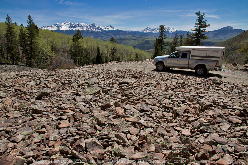
The road narrowed, crossed a talus field, and got quite rocky. I was remembering what the Land Rover drivers had emphasized "go as slow as possible; as fast as necessary."

Talus Slope (this photo was actually taken on my way back down the mountain.)

I came to a wide spot in the road with the ruins of an abandoned cabin in a turn-out, so I stopped there to evaluate if I wanted to proceed. I could see a water crossing down the hill and could make out the road clinging to the side of the next mountain, climbing steeply.

I saw an older model, high-clearance 4WD truck of some type come up the hill toward me. I waved and they stopped. I asked them how the road was ahead. They replied with a name I didn't recognize and I quickly realized they didn't speak English. Chagrined that I'd grown up in New Mexico and didn't speak Spanish, I nonetheless asked, "¿Via esta bueno?" As pathetic as my attempt to communicate was, they understood what I was asking. The driver shook his head and the passenger waggled his hand in the universal gesture of "not so much." As I only had street tires on my truck, I decided not to push my luck and turned around to head back down the mountain. (There is a hidden irony here which I will share in an upcoming post from my next trip to Colorado.)

On my drive up earlier in the day I had noticed some possible dispersed campsites along the highway below the village of Rico, so drove down to check them out. I'd also seen a side road next to a creek in the same area on my way up. I came to it first and turned east to check it out. It was an old wagon road following Scotch Creek that connected Rico to the Animas Valley back in the 1870s. The informational sign indicated it was only suitable for 4WD vehicles, but I was game for a try.


It was very rocky and again I was concerned for my OEM tires and walked part of the road to make sure I had clearance before driving up. I only had to go about a quarter of a mile to find a wonderful campsite right next to to the creek (which was larger than some rivers in New Mexico.) After setting up the camper, I walked around the immediate area admiring the trees, canyon walls, butterflies, flowers and always the roaring creek. Late that evening I saw my first Marmot making its way across a talus slope near my campsite. It was delightful that night falling asleep to the water's song.

This photo shows how close I was to the wonderfully musical creek.

My campsite. Didn't realize until later how the tree leaned over me.

The next morning I walked up the canyon about a mile or so, watching the birds and admiring the beauty of the canyon. At the upper end of my walk I got my macro lens out of the bag and enjoyed photographing some of the tiny flowers around my feet. Here are some photos from that morning.

Typical of the canyon walls with rock cliffs and talus slopes; fir and aspen.

Butterflies were flitting from flower to flower.

A pretty blue violet hiding in the grasses in a shady area of the forest floor. Macro photograph.

The road winds up the canyon.

A colorful Western Tanager briefly out in the open.

Teeny, tiny white flowers. Macro photograph.

The road is uncharacteristically smooth in this spot.

Many of the butterflies were also lapping up minerals where the ground was wet.

There were lots of Juncos foraging along the ground.

This individual looks worn, but not as much as others of this species that I saw.

The columbine flowers in the canyon had not quite opened. Macro photograph. 

After my walk, I had a spot of lunch and began packing for my return to civilization. This unplanned stop in Colorado had been the perfect end of a fabulous trip that had begun with Overland Expo, a run up the Great Western Trail in Arizona and an interesting journey across southern Utah (covered in previous posts.) All in all, a roaring success in my trusty Tacoma and camper!

Thanks for reading along.