
Showing posts with label off-highway. Show all posts

Tuesday, June 18, 2013

Brief Foray into Colorado

I'm falling behind. As I write this post I've already completed another trip to southwestern Colorado and I haven't even worked through the Bryce Canyon photos from this trip, yet. So much to do; so little time.

This post covers my last stop on my way home from Overland Expo 2013 in Flagstaff. In the last post I was leaving Utah on my way to Colorado. I took US-491 from Monticello, UT to Cortez, CO. Another area where I had no idea there was so much agriculture. Apparently beans are a major crop in this area, and cattle ranching. In Colorado on the way to Cortez I saw genuine cowboys herding cattle from horseback.

Since I hadn't planned on coming to Colorado this trip I hadn't yet purchased the Benchmark map atlas of Colorado and since it was a week-end the forest service information stations were closed. No matter, I refueled in Cortez and I'd wing it. Other than a quick trip up to Colorado Springs and Denver last fall when I drove my sedan up to check out the Four Wheel Campers in person, this would be my first return to the state since the mid 1970s.

I headed north on Colorado Highway 145, a.k.a. Railroad Avenue, which runs alongside the Dolores River toward Telluride. Once I got to the town of Dolores the countryside changed from open piñon and juniper to forests and mountains. Unfortunately, I was so busy admiring the view I forgot to take a picture.

As I made my way up the canyon into the San Juan Mountains a big smile crept across my face. This was looking like the Colorado I remembered and loved to visit back when I was a young man with a VW Campmobile! Nothing as beautiful as the west slope with the towering, snow-capped mountain peaks.

View along the highway, part of the "San Juan Skyway" scenic highway route.

I took a few photos of the mountains from the highway, but they just don't convey the beauty of the area. As I got closer to Telluride the peaks got higher and even more beautiful. I wasn't sure if I'd visited Telluride all those years ago. I remembered Durango, Silverton, Ouray, Gunnison, and Aspen, but as soon as I saw Telluride with the sheer mountain face and the long, narrow waterfall behind it, I remembered that view for sure. Breath-taking!

Telluride, Colorado

I drove into town just to see it, not really to stop and visit. Good thing, as it was crowded. I got a map at the tourist bureau and asked if the Last Dollar Road was open. The nice lady replied that the guys who ran the jeep tours business next door had just told her that it was indeed open. I hadn't planned to do that road this trip, but I did have my Colorado Backroads guide book which had directions and a map.

I left town and the turn-off to Last Dollar Road was well marked. I drove past the very small airport and marveled at the number of fancy jets on the apron and limousines in the parking lot. Yes, lots of money up in this neck of the woods. The road was graded at that point with private drives to both modest cabins and top-tier estates.

A bit farther up the road and another cowboy rode into view leading about a dozen horses. Gotta love Colorado.

Moving the horses to fresh pasture.

The road climbed and climbed and the views were spectacular.

You should view this photo in a larger size.

The road moved up into an Aspen grove and saw this warning sign - looked like they meant business.

CAUTION
Very slick mud when wet next 8 miles
4-wheel Drive
Good Tires Only

The road narrowed, crossed a talus field, and got quite rocky. I was remembering what the Land Rover drivers had emphasized "go as slow as possible; as fast as necessary."
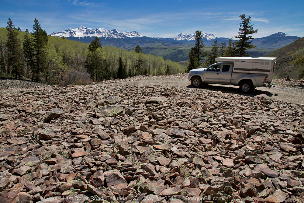
Talus Slope (this photo was actually taken on my way back down the mountain.)

I came to a wide spot in the road with the ruins of an abandoned cabin in a turn-out, so I stopped there to evaluate if I wanted to proceed. I could see a water crossing down the hill and could make out the road clinging to the side of the next mountain, climbing steeply.

I saw an older model, high-clearance 4WD truck of some type come up the hill toward me. I waved and they stopped. I asked them how the road was ahead. They replied with a name I didn't recognize and I quickly realized they didn't speak English. Chagrined that I'd grown up in New Mexico and didn't speak Spanish, I nonetheless asked, "¿Via esta bueno?" As pathetic as my attempt to communicate was, they understood what I was asking. The driver shook his head and the passenger waggled his hand in the universal gesture of "not so much." As I only had street tires on my truck, I decided not to push my luck and turned around to head back down the mountain. (There is a hidden irony here which I will share in an upcoming post from my next trip to Colorado.)

On my drive up earlier in the day I had noticed some possible dispersed campsites along the highway below the village of Rico, so drove down to check them out. I'd also seen a side road next to a creek in the same area on my way up. I came to it first and turned east to check it out. It was an old wagon road following Scotch Creek that connected Rico to the Animas Valley back in the 1870s. The informational sign indicated it was only suitable for 4WD vehicles, but I was game for a try.


It was very rocky and again I was concerned for my OEM tires and walked part of the road to make sure I had clearance before driving up. I only had to go about a quarter of a mile to find a wonderful campsite right next to to the creek (which was larger than some rivers in New Mexico.) After setting up the camper, I walked around the immediate area admiring the trees, canyon walls, butterflies, flowers and always the roaring creek. Late that evening I saw my first Marmot making its way across a talus slope near my campsite. It was delightful that night falling asleep to the water's song.

This photo shows how close I was to the wonderfully musical creek.

My campsite. Didn't realize until later how the tree leaned over me.

The next morning I walked up the canyon about a mile or so, watching the birds and admiring the beauty of the canyon. At the upper end of my walk I got my macro lens out of the bag and enjoyed photographing some of the tiny flowers around my feet. Here are some photos from that morning.

Typical of the canyon walls with rock cliffs and talus slopes; fir and aspen.

Butterflies were flitting from flower to flower.

A pretty blue violet hiding in the grasses in a shady area of the forest floor. Macro photograph.

The road winds up the canyon.

A colorful Western Tanager briefly out in the open.

Teeny, tiny white flowers. Macro photograph.

The road is uncharacteristically smooth in this spot.

Many of the butterflies were also lapping up minerals where the ground was wet.

There were lots of Juncos foraging along the ground.

This individual looks worn, but not as much as others of this species that I saw.

The columbine flowers in the canyon had not quite opened. Macro photograph. 

After my walk, I had a spot of lunch and began packing for my return to civilization. This unplanned stop in Colorado had been the perfect end of a fabulous trip that had begun with Overland Expo, a run up the Great Western Trail in Arizona and an interesting journey across southern Utah (covered in previous posts.) All in all, a roaring success in my trusty Tacoma and camper!

Thanks for reading along.

Saturday, June 1, 2013

Great Western Trail - Orderville Canyon, Arizona to Utah

May 20 and 21, 2013

After the Overland Expo I had planned to take about a week to do a scenic drive back to New Mexico. I hadn't visited much of northern Arizona or southern Utah before and thought it was high time to remedy that situation. The rough plan was up US89 and US89-A through Jacob Lake to Bryce Canyon to visit a friend who is a Ranger there. Then a quick scoot across Grand Staircase-Escalante National Monument gathering info for a longer, return visit. Camping at Capitol Reef NP, Natural Bridges, Muley Point, and then it would be about time to be home. Oh, the best laid plans... Future blog posts will cover these events, but I'm getting ahead of myself.

Sort of at the last moment on Monday I thought it would be a fun adventure to take a backroad north from Jacob Lake to Utah instead of following the paved highway the entire way. I had seen the "Orderville Canyon" trail in the Guide to Arizona Backroads & 4-Wheel-Drive Trail book, by Charles A. Wells and Matt Peterson. The book said, "Easy. Mostly graded road with one steep hill. Suitable for stock 4WD SUV's with high clearance.... Time: 2 to 3 hours." Hey, that sounded ideal - a beautiful backcountry drive, maybe with a chance to practice some of the skills I'd picked up at the Expo, too. Sign me up.

The Great Western Trail is a unique corridor of braided and paralleling trails for both motorized and non-motorized users. The trail system traverses 4,455 miles through Arizona, Utah, Idaho, Wyoming, and Montana. It incorporates stunning desert and canyon landscapes, plateaus, woodlands, dense forests and alpine meadows. It links 18 National Forests, Tribal, State and BLM administered lands and encompasses the most diverse vegetation, topography and wildlife in the western United States.

I did my due diligence and stopped at the Kaibab National Forest Ranger Station in Jacob Lake to check on my route. The woman at the information desk was familiar with the route (and the guide book in my hands to the point of even recognizing it was a new edition) and cautioned me that the whole middle section was no longer maintained, but since I had a high clearance 4WD, and as long as I was careful, I shouldn't have any problem.

Sign announcing the start of this leg of the Great Western Trail.

I drove the 3.2 miles east from Jacob Lake on the highway and found the turn-off to FS 257. It was 3pm, but as it was late spring I had plenty of light left I figured. Anyway, the plan was to find a nice dispersed campsite along the way and complete my drive to Bryce in the morning.

The beginning of the GWT east of Jacob Lake at US-89, look north, the direction of travel.

The trail follows the ridge of the Kaibab Plateau populated with tall Ponderosa Pines through which the roads meandered. There are numerous dispersed camping sites in the first few miles, many of them large enough for sizable trailers.

Grass and tall trees for the first several miles of this trail.

One tricky aspect of this route is that there are numerous other forest roads intersecting this one. The guide book gives directions for each turn or junction with milage, but even better, the Forest Service (and BLM) have erected markers with the Great Western Trail icon pointing the way.

Various groups have also erected informational signs along the trail. These give those who pause to read a bit of the history of the trail and the settlers who moved in, such as the Mormon group who established Orderville and set up a dairy in this canyon. (In this section the signs were placed by the Arizona State Parks Off-Highway Vehicle Fund. Sorry, I didn't pause to photograph these signs.)

There were wild flowers blooming. Quite lovely.

The elevation of the plateau drops rapidly. Five miles in, the big trees are thinning in favor of smaller trees and plants of lower heights. By 10 miles instead of grass and pine needles along the ground one finds profuse growths of sage and other high-desert plants, though there are still pines lining the wide canyon walls.
Lark Sparrow

It was interesting to me to note that in some sections, between junctions, there was evidence of vehicles passing not that long before I came along. In other sections my tracks were the first since the last rain - which had to be some time past.

Once out of the big trees I was into Piñon and Juniper forest. The canyon would narrow with rocky walls, then would widen out showing evidence of old corrals and not so old cattle grazing. Camping spots were becoming few and far between, in fact in most places there was not even any way to get out of the roadbed.

Sure enough the road was not maintained in this area, though rocky and heavily rutted in sections, it presented no obstacle. It did require attention to where I placed my wheels, so there are no photos from this fairly long section.

Somewhere along here I began to realize traversing this trail would take longer than the 2 - 3 hours as published. I decided I wouldn't stop until I had travelled farther along, as I wanted to get into Bryce Canyon the next day early enough to be sure to get a camp site.

The road became rougher, though still through interesting territory. I was on the lower sections of the plateau, but had not reached "the hill." This feature, mentioned in my quote, above, from the guidebook carried the admonition on the map itself, "Toughest section; use 4-low going down." There was also a camera icon just before the hill on the map, promising a great view. The terrain was becoming more open and arid, as the road twisted, rose and fell. Then it opened up and I knew I was there - mile19.4, the steep hill.

View of the southern flank of Utah from the edge of the Kaibab Plateau (the hill.) View larger image
After taking some photos, I had hearty snack as the day was getting long and my energy was getting low... and I suspected I'd need some energy soon. I put the truck in 4WD-Low and started easing down the steep, rocky road. Keeping in mind what the Land Rover drivers continuously said, "as slow as possible; as fast as necessary."

That slow as possible quickly became a stop as there was an intimidating rock ledge the width of the road with an abrupt drop-off on the low side. The drop was about a foot on the driver's side and a somewhat less abrupt 8 to 10 inches on the passenger side.

This is where "ego" gets us into trouble, I can almost hear Fred Monsees, the Land Rover driver explain in his "how things get broken" class! I had to figure a way down or turn around and drive the now 3 hours back to US89. When I'd read the trail classifications in the guidebook, the Moderate rated trails had been described as "may require some rock stacking." I decided that this Easy trail had become Moderate since the book was written.

I decided to try rock-stacking. It took me a while to build two ramps off the ledge and to remove the rear steps from my hitch receiver so they wouldn't drag. I should have taken photos, but I was totally focused on the task at hand. Started the truck up and eased down my ramps, careful not to try and stop while on the ramps lest the rocks shift under me. Success! The only things that scrapped were my mud flaps. I stuck the steps back on and proceeded hoping that was the worst part... until I came to the next ledge.

This one wasn't as bad and I could put one wheel on the side of the track, so only had to build one rock ramp (and remove my steps and do a little dead limb trimming.) After I cleared this ledge and worked my way down, the shadows were getting long and finding holes to avoid a little more difficult. But no more rock stacking required. Whew!

It seemed like it took forever to get down that hill, but looking back at my GPS log, it only took about 40 minutes total. OK, so maybe you guys in your big trucks, Jeeps or FJs could have just driven straight down, but newbie me in my heavily loaded, brand-new, stock 4x4 Tacoma decided not to dent or break anything this time.

About a mile after the hill, with the road a fairly smooth "thoroughfare"  I found a little spur off the road, that lead nowhere, to camp. I nestled in among the Junipers, off the "main" road. Not that I thought anyone would be coming down that road in the dark in a million years.
My cozy campsite with the last rays of the sun lighting the tops of the Juniper.
I even had time to take a short walk before dark. I saw some game trails, but no game. I had a restful night.

The roads were much better in the morning, though I confess to taking one wrong turn. I figured it out quickly, backtracked and got back on the trail.

You can see the Utah escarpments along the horizon.
I knew I was on the right trail once I saw the identical sign as was pictured in the guidebook.
I've made it to Utah all in one piece.

Climbing up to US-89 the views were still spectacular.

Click to view larger image.

The roads in Utah were well maintained and I touched 36 m.p.h. before good sense returned to me. The route brought me out onto the highway about 20 miles east of Kanab.

All in all, a good adventure with truck and driver surviving with nothing more than a few scratches on the skin. The 2 - 3 hour trail took me 5-1/2 hours, not counting camp time. I talked to a fellow a few days later about this. He uses a different author's guidebook, but noted it usually took him about twice the time listed in the book, so I guess this is endemic to the trade.

Thanks for reading along.

Here is a track map and profile taken from my GPS, should you be interested. I do not recommend taking this route with only my map as a guide. The red pin, "Camp GWT", marks my campsite; the other pin marks the origin.


You can see the steep hill at about 20 miles.


p.s., I phoned Matt Peterson of FunTreks.com, one of the authors of the guidebook to see if he was interested in a trail condition update. He was, as he said it had been two or three years since they'd last driven it. Seems like a good guy. He said to keep watching the site as they will be coming out with a phone app of their own onto which you can load tracks (for off-grid use) for the trails in their books. He said the current scheme using a third-party app hadn't been satisfactory. They also sell data cards that plug into various brands of vehicle navigation devices and show the routes and waypoints.