
White Rim Trail Pop-up Camper Expedition - Day 1 of 5
April 2, 2017
Click any photo for larger version!
Introduction
If you are not already aware, the White Rim Trail (WRT) is a 100 mile 4WD, high-clearance only road that loops around and 1000 feet below the Island in the Sky mesa top in Canyonlands National Park, Utah. It gets its name from the White Rim Sandstone that is situated mid-way between the mesa tops, and the canyons of the Colorado & Green Rivers. There are a number of established campsites, well spaced, each with a vault toilet. There is little to no shade, which is why most visitors avoid travel during the very hot summer months. Permits are required for travel and camping. Here is a map showing in red how the WRT wiggles and wags between the mesas and rivers. We proceeded in a clockwise direction. I have also placed the map location as a red rectangle within the outline of the state.

The White Rim Trail journey begins at the Canyonlands Island in the Sky Visitor Center. This is where you check in to learn if there are any last minute status changes on the route and to ask any questions. You should already have permits to drive or bike and camp on the trail. Only a limited number are available and they go months in advance for the prime seasons of spring and fall. Permits are for a maximum of 3 motor vehicles and 15 persons. This allows for supported bike trips.
At the VC you can also visit the bookstore for books and souvenirs. I highly recommend A Naturalist's Guide to the White Rim Trail by Williams and Fagan. In fact I recommend you buy it in advance online from the Canyonlands Natural History Association. It describes the full trail with milages and maps. It also has sections on plants, wildlife, history, geology, and planning your trip.
The Journey Begins
I had met up with Bob, John, and Dan the afternoon before at "Little Round Top" (read that post here), a BLM dispersed campsite I'd discovered two years before. I met all these gentlemen through the Wander the West forums - a great resource, especially for pop-up camper owners or wannabes. I'd met Bob in person last fall at a WtW meet-up at Valley of the Gods (first part of that blog post.) I had never met John in person, though we had exchanged many emails as we both bought nearly identical trucks and campers at the same time. Dan is John's brother, he lurks on WtW, but I only knew him from John's emails.
Bob was driving his Tundra with a FWC Hawk; Dan was driving his Tacoma with ATC Bobcat; his brother John, who has a Fleet like mine was riding along as he was just recovering from foot surgery. We drove into the park to the VC to check in and reset our odometers - the milage references in the book mentioned above begin at the VC.
From the VC we drove back north a mile, then turned off the pavement east onto Shafer Trail. We stopped at a wide section where Bob and I "aired down" to make for a softer ride over the anticipated rocks. Dan did not and later had no complaints. Most who travel the WRT go this direction, clockwise. I wish the park service would make the road one way from Musselman Arch to Mineral Bottom to remove the conflicts of vehicles trying to go up and down the many narrow, steep sections of the trail.
Shafer Switchbacks
I'd driven up the Shafer Switchbacks the previous autumn, but this time we were descending.
 |
| Photo op at the top of the switchbacks before the descent. |
 |
| Dan approaches the edge carefully. |
 |
| It is a long way down! |
 |
| There goes Bob. |
 |
| I can see the bottom now. |
It was a beautiful morning with grand vistas. There were a number of cyclists peddling up and I spoke (hopefully) encouraging words to each as we passed.
 |
| Closer to the bottom now. |
 |
| Looking back up from where we descended. |
At bottom of the canyon, Shafer Trail turns left to connect to Potash Road. White Rim Trail officially begins at this point.
Bob had obtained our permits and those were chosen for accompanying bike riders, so we had permits for four nights. The bike riders had to drop out only about a month after Bob got the permit, which allowed Dan and John to join us. This also meant we would have plenty of time to stop for photos and hikes as we drove along.
Our first stop was the Colorado River Gooseneck Overlook. You will probably get tired of reading "amazing", "wonderful", "spectacular", etc. when describing the views all along the trail. Understand, though, if you are lucky enough to make this trip, you will not get tired of those amazing, wonderful and spectacular views! This was such a view.
Gooseneck Overlook
 |
| Bob and Dan admire the view. |
 |
| A panorama of the Colorado River gooseneck. |
 |
| I love this view toward the north along the top of the overlook. |
Musselman Arch
We next stopped at Musselman Arch where we first encountered a group of mountain bikers on a supported tour run by Western Spirit. We would play tag with them for the rest of our journey along the trail. FYI, the road from Island in the Sky to this point is considered suitable for most passenger cars and many folks get a permit just to drive to the arch, then back out. The arch is comprised of White Rim Sandstone and thus is "level" with the terrain, unlike those at Arches National Park.
| Musselman Arch |
 |
| Looking length-ways across the arch. Photo by Bob. |
 |
| Musselman Arch |
Along the trail
 |
| Dan (and John) and I. Photo by Bob. |
 |
| Along the trail. Photo by Bob. |
 |
| A view of part of the Island in the Sky mesa top. |
 |
| White Rim Sandstone along the way. |
 |
| Here you can see where the White Rim Sandstone has fallen into the canyon. |
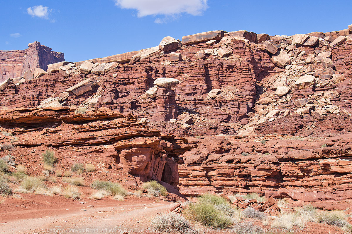
Lathrop Canyon
Only a mile before our first campsite at Airport Tower, is a side road that leads down Lathrop Canyon to the Colorado River. The initial stretch is very steep and the road disappeared around a sharp turn. The guys decided they'd rather continue on to set up camp, but I wanted to drive the four miles down to the river. So I gathered my courage and did so. It turned out not to be bad at all after that first pulse-pounding descent, though you wouldn't want to do it after a heavy rain as the road crosses the wash many times along the bottom of the canyon. There are no photos of the tricky parts of the road as I was too busy driving and it was too steep to stop and get out.
 |
| Looking back along the canyon bottom. |
 |
| Looking forward from the same spot as the photo above. |
There are picnic tables and a vault toilet once you reach the river.
 |
| Looking upstream. |
 |
| Looking downstream |
 |
| Turn-around and picnic table. |
 |
| Another view. |
 |
| An old cottonwood tree surviving along the road as I drive out. |
 |
| Continuing up canyon. |
 |
| Farther up the canyon you can see where the White Rim has cracked off and fallen. |
I drove back up the canyon and got out just in time. There were three jeeps getting ready to drive down and it would have been trouble to meet them on the very narrow, very steep section.
Airport Tower Camp B
I found the guys set up at our assigned campsite. Campsites are marked by 4 posts; you are required to only camp within the boundary set by those four posts. I found a spot nearby that had the proper slope to put my head a bit higher than my feet and to put the fridge on the shady side of the camper. It was warm enough to take off my jeans and put on my shorts.
 |
| Our first night's campsite. |
Unfortunately that warm sun was short lived. Clouds moved in by dinner time and we thought it might rain. It didn't rain on us, but brought dramatic clouds.
 |
| Bob looks chilly. John and I are relaxing. You can see the threatening clouds in the background. Photo by Dan. |
There are no campfires allowed anywhere on the WRT (as in many public lands in this era of drought) but Bob checked with the park service to ascertain if we could use a "propane campfire." No one had asked that question before, so it took them a little time to decide, but the answer was "yes." Bob had bought one by Quick Fire to use at Tuweep and along the WRT. It worked very well. Maybe not quite as satisfying as an actual wood fire, but quick and easy to set up and turn off, and still fun to sit around after dinner while trading stories and enjoying adult beverages! We used it every night on the trip.
 |
| Storm cloud off to the northeast. |
 |
| A last reflection of the sun. |
This concludes Day 1. The story continues on Day 2.
So I”m looking to do the white rim trail in June, however, I was going to pull a turtleneck pop up trailer, what are your thoughts on a pop up on this trail?
ReplyDeleteUsing an FJ cruiser to pull. I will be there 15-18JUN....not sure how hot it will be and but guesstimating 85-90....
I cannot recommend any kind of trailer on this trail. You'd be OK for most sections, but not all as there are some super tight switchbacks. For instance I could not make it up the first switchback on the south side of Hardscrabble Hill without having to back up in my Tacoma!
DeleteUpdating my reply above: on further thought I retract my "You'd be OK for most sections" as I don't think you could get a trailer down to those sections. So I'm saying now Do Not take a trailer on the White Rim Trail.
Delete