June 24th to 27th
I wanted to escape the heat of central New Mexico and head for the cool mountains of Colorado. My idea was spend a few days in the southwest portion of the San Juan Mountains exploring the area around the West Dolores River where I never been. I didn't intend to stay long, just a few days, not even through the weekend. This was a quick decision as I realized the following week would be part of the July 4th holiday get-away for lots of others, and I wanted to avoid those crowds.
Remember to click on a photo to view at a larger size.
Part 2
Friday, June 26
A chilly morning. It was much colder at this elevation (around 10K), abetted by the affect of the ice cold stream running down the canyon. I packed up after breakfast and headed down 611 to turn left on the Dunton Road, AKA County 38, AKA FS-535, to the Navajo Lake trail head.
Navajo Lake Trail
 |
Informational sign at the trailhead.
(I photoshopped the bullet hole out of the Navajo Basin. Sigh, some people!) |
This is one of the trails leading into the Lizard Head Wilderness. There were about four vehicles parked at the trail head when I arrived. I slathered on the sunscreen, laced up my boots and headed up the trail. Right from the start the views were wonderful. The West Dolores River was to the left of the trail and up ahead I could see Dolores Peak. The trail was crossed by small brooks of snow runoff and some of these were muddy. I recalled the comment by a lady I met on the Geyser Spring Trail yesterday that the trails were just now dry enough to hike.
 |
| Lower section of the trail |
The trail wound between trees then through small meadows with wildflowers. Then it crossed the river and climbed up to a higher plateau.
 |
| West Dolores River |
 |
| Shooting Star Columbine - one of my favorites. |
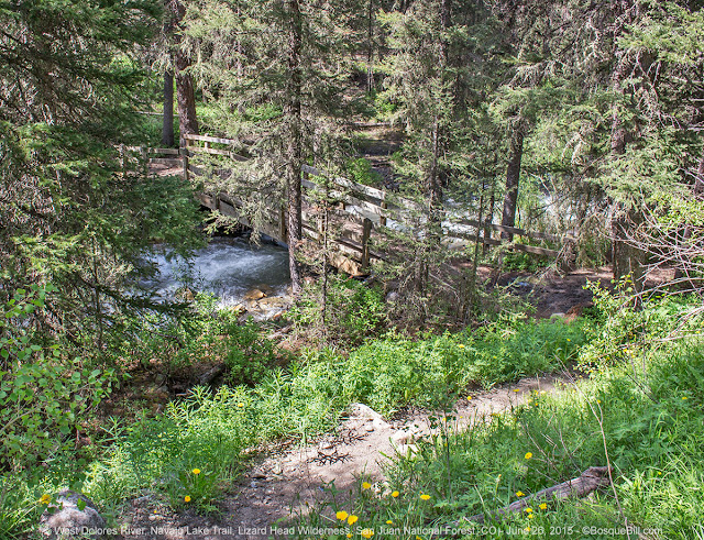 |
| A look back at the footbridge as the trail climbs away from the river |
Here there were much larger meadows green with growth. There were lots of wild iris and other flowers. There were also very large patches of Corn Lillies, AKA False Hellebore (
Veratrum californicum), though which the trail would transit. Occasionally, there were small brooks crossing the trail and resulting muddy areas. For much of this stretch the river was off to the right and far enough that it could no longer be heard.
 |
| Unnamed 11079' peak |
 |
| El Diente Peak and Mt. Wilson with Corn Lillys in the foreground |
The vistas of the mountains were spectacular as El Diente Peak and Mount Wilson Peak came into view. I just keep taking photos. After passing through a small wood and climbing up to the next meadow, Dolores Peak was lost from view, but the range ahead grew dramatically in my perspective.
 |
| The views just kept getting better and better. |
I could hear the river again and it sounded like there was a waterfall. The trail ran close to the edge of the river canyon and I could just glimpse the torrent below. A small side trail lead steeply down to where there was probably an amazing view of the cascades, but knowing my physical limits, I kept to the main trail. I also saw a couple of early blooming Colorado Columbines - the plants were loaded with buds that looked like they would open in just a few days, certainly by July 4th.
 |
| Colorado Columbine, one bloom and many buds. |
As I passed though each meadow I made attempts to photograph some of the many butterflies flitting all around. But they would not pause long enough or near enough for my camera. At a little over a mile and three-quarters I came to a meadow with an array of flat rocks and delightful views of the mountain peaks. I chose this spot to pause and rest. I picked a rock on which to sit and enjoyed my snacks while drinking in this fabulous view. I decided I'd turn around at this point while my feet and legs were still cooperating.
 |
| The meadow on which I rested and admired the view |
 |
| Wild Iris |
The return trip was just as delightful as on my way up, but I confess I was tired and hot by the time I reached my truck.
I sat in my truck, caught my breath and got my energy back up with a fruit yoghurt. Then I drove up and east on the county road, passing once again The Meadows and the turn off to Calico Trail. This was the stretch the lady at the ranger station was so leery of my driving. As I continued down the very nice road I encountered only very few short stretches of rough road, nothing that a passenger car would have had any problem with. So I kept expecting some terrible deterioration of the road. I came to the switchbacks and followed them down to the highway. I never found the terrifying road of which she spoke.
Scotch Creek
I turned right on CO-145 toward the mountain town of Rico (FYI, the only spot within many miles with cell phone service). I stopped at the bar & grill that was open, hoping for a hot meal, but the kitchen was closed as the cook had failed to show for work. I continued down the highway. I planned to check out Scotch Creek to see if my favorite camping spot was available. It was! Hooray!
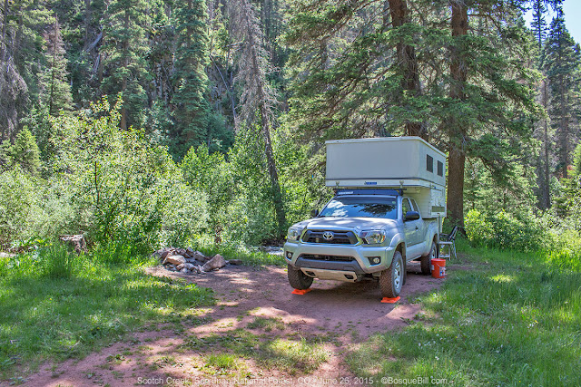 |
| My favorite campsite. Scotch Creek is just to the left of my truck |
I set up camp with my chair and table overlooking the stream. I sat and relaxed, enjoying the scenery and the rushing creek. The site is only about a quarter of a mile from the highway, but that is far enough that no traffic sounds are louder than the creek. The site is barely off the rocky, rough road, however the road is so bad that the few jeeps and ATVs that pass by are going very slowly, so no dust, no muss.
 |
| A study in contrasts |
After a while I thought I'd walk up the road to stretch my stiff legs and view the scenery up the narrow canyon. I'd nearly forgotten how beautiful the canyon is with its steep rocky walls, cliffs really, and scree falls. It was very pleasant to stroll along and snap a few photos.
 |
| Scotch Creek Canyon |
 |
| Interestingly bent aspen |
 |
| Another view of the canyon and 4WD road |
 |
| Orange Sneezeweed sure is pretty |
I returned to my campsite and decided to have a toast to celebrate the day and the scenery, while again resting my bones in my chair next to the creek. It was a beautiful evening and I had a good night next to the babbling brook.
Saturday, June 27th
I'd planned to head back to civilization today, but I had time for a short walk and I wanted to break out my macro lens for the wildflowers in the canyon.
 |
| Leafy Jacob's Ladder |
 |
| Four macro-photographs of wildflowers |
I packed up and headed down the mountain, filled my tank with reasonably priced gasoline in Dolores and stopping at Zio's in Durango for fish tacos. Yummy. Then it was just the long slog home across the hot plateau.
All in all, an excellent trip with great campsites. I was able to camp next to rushing water each night and saw many wonderful views. Thanks for reading along.


