
Historical Trip Report from July 1996
[Edited on January 4, 2015: This is the original trip report I wrote in 1996, which I stumbled upon recently. I found the old text file on my hard drive and even found the photos I'd taken on the trip. I scanned a number of the 4x6" prints from the inexpensive, fixed-focus camera I had at the time and have tried to revitalize them, best I could, with Photoshop. I had not labelled the photos, so used Google Maps to try to identify the locations. In the course of this search, I corrected the place names in this report that I'd originally misidentified; the rest of the report is just as it was written.]
[Remember, you can click on any photo to see larger versions of all the photos from this trip.]
Motorcycle Tour of Northern California and Oregon
Summer 1996
Background and Preparations
I've lived in California since 1979 and there are lots of areas of this and nearby states that I have never seen. I decided to remedy this situation by going motorcycle camping. As a destination I would use Portland, Oregon where my good friends Ralph and Betty moved a couple of years ago and I had also never been. I used my Kawasaki EX500 for the trip. It would have been much nicer to have a real touring cycle, but that is not in my financial plans. Other motorcyclists warned me that my little bike would "beat me up", but I wasn't too worried having ridden the entire Pacific Coast on my pedal bicycle.
There are no touring accessories offered for the EX as it is strictly a street/sport machine, excellent for maneuvering twisties of coast, canyon and commute. So I resolved to engineer a way to use my existing bicycle touring bags and camping gear. If I was only going to tour and camp this may have been sufficient, but as I was planning to spend several days, perhaps a week, in civilization with my friends I needed to take along extra clothes, shoes, etc. I came up with a plan to make additional space by using a Rubbermaid Store-All container. It looks like an ice chest, but is not insulated. I found aluminum extrusions that I could use as struts and supports at the hardware store and fashioned my "trunk" and supports to hold my bicycle panniers (saddle bags). Total cost was less than $25. I borrowed a back-packing stove for making morning coffee from a friend who also rides and he volunteered to also lend me his motorcycle tank-bag. This bag straps on top of the gas tank and proved invaluable for carrying many of my heaviest or most frequently needed items (thanks, John).
I would stop each night at a little store before camping to buy provisions for dinner and a half pint of milk for my usual morning granola. I pre-ground coffee which I placed in individual paper filters. The stove was easy to use to heat water which I "dripped" through the filter for the strong coffee I favor. This worked out well. I planned to wear the motorcycle suit I acquired for commuting as it provides the best protection in case of accident and is very versatile in changing weather conditions. I brought along a wool shirt, sweater, and winter riding gloves in case of cold weather. I had been told that the suit could be "air conditioned" by wearing a long sleeve T-shirt underneath the jacket which could be wet down for the evaporative affect (this turns out to work well).
Wednesday, July 10, 1996
I got a late start and ended up in the late afternoon commute in SF and the East Bay - what a big mess and hot, too. Usually, while commuting I "share" lanes with the other traffic and cut through the jams, but this time with all my junk the bike was fatter and less maneuverable, so I decided to just tough it out. The ride up I80 was not fun, but after I turned off at Auburn and got into the mountains (State Route 49) my mood improved considerably. It was a beautiful two-lane highway above Grass Valley (whose historic downtown was used in the current movie Phenomenon). I found a great campsite along the banks of the North Yuba River run by the US Forest Service. It was fun to see the signs along the river warning folks the mining rights belonged to others; i.e., don't get caught panning for gold.
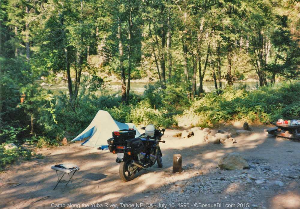 |
| First night's campsite. I don't know which campground this is. |
Thursday, July 11
 |
| I'm guessing this is the Feather River area to which I refer in my report. |
 |
| Somewhere along the highway to Lassen Volcanic National Park. |
It was very pleasant the next morning going over Yuba Pass and then north on State 89. The scenery was enjoyable in the Feather River area, grassy valleys between pine covered hills, but it started warming up around Graeagle. It cooled a little as I skirted Lake Almanor, a boater's paradise in the Sierra. By late afternoon I was entering Lassen Volcanic National Park. I had been seeing Mt. Lassen's spectacular snow covered peak for hours. As the elevation rose the temperature thankfully dropped.
 |
| A geothermal hotspot in Lassen Volcanic National Park. |
 |
| The highway skirted Mt. Lassen. Snow in July! |
Lassen Park is absolutely fantastic. The rode climbs and curves past active geothermal areas, snow fields, and frozen lakes. The views are breath taking vistas for miles and miles across the Sierra Nevada. The highway climbs remarkably close to the peak then circles around to the other side of the mountain as it descends. I camped in a verdant spot (mosquitoes not withstanding) and befriended a couple of lady school-teachers from Eureka, California. They plied me with an excellent Chardonnay and told stories of their adventures in the geothermal areas. This area demands a repeat visit, perhaps soon.
 |
| My campsite in the park. I'm only somewhat confident this was in Summit Lake South Campground. |
Friday, July 12
I awoke early and took a little hike before gathering my gear and starting out. Beethoven's Ninth Symphony on my portable CD player connected to my helmet speakers was fitting accompaniment to scenery leaving Lassen. I continued on Route 89 toward Mt. Shasta. The countryside along the route was mostly forested, but unremarkable. Mt. Shasta was visible for hours, a lone sentinel of the igneous earth, head and shoulders above the surrounding lands.
 |
| Mount Shasta |
If you need a place to stop for food in the town of Weed, I can recommend the Y Restaurant at the junction of US97, which was to take me to Klamath Falls, Oregon. The old-timer at the Oregon Visitors Information Booth confessed that there were no falls there [in Klamath Falls]. They had long been drowned by Klamath Lake Dam.
Before leaving California, though, the highway traverses some dramatic volcanic lava flows and, as was fitting, the afternoon was getting hot. The scenery was interesting, but not especially noteworthy until I reached Crater Lake. Again the change in altitude was refreshing and the views across the lake to Wizard Island and the panoramas of adjacent mountains provided lots of photo opportunities.
 |
| Crater Lake - panorama stitched from three photographs. Click for a larger version |
I rode the west rim of the crater before heading toward a recommended campground at Diamond Lake. The recommendation was a great one. I got a beautiful, conifer enclosed campsite a stone's throw from the crystal clear lake which reflected the snow capped image of the volcanic peak of Mt. Bailey. Lots of trees and birds and flowers helped to convince me that this is a place to revisit. Instead of using the park's shower I opted for a swim in the lake which was cool, not cold, and very refreshing after a days ride. I would like to come back here to camp again. It was also the least expensive of all the campgrounds, only $7 for my beautiful tent site.
 |
| Campsite at Diamond Lake. |
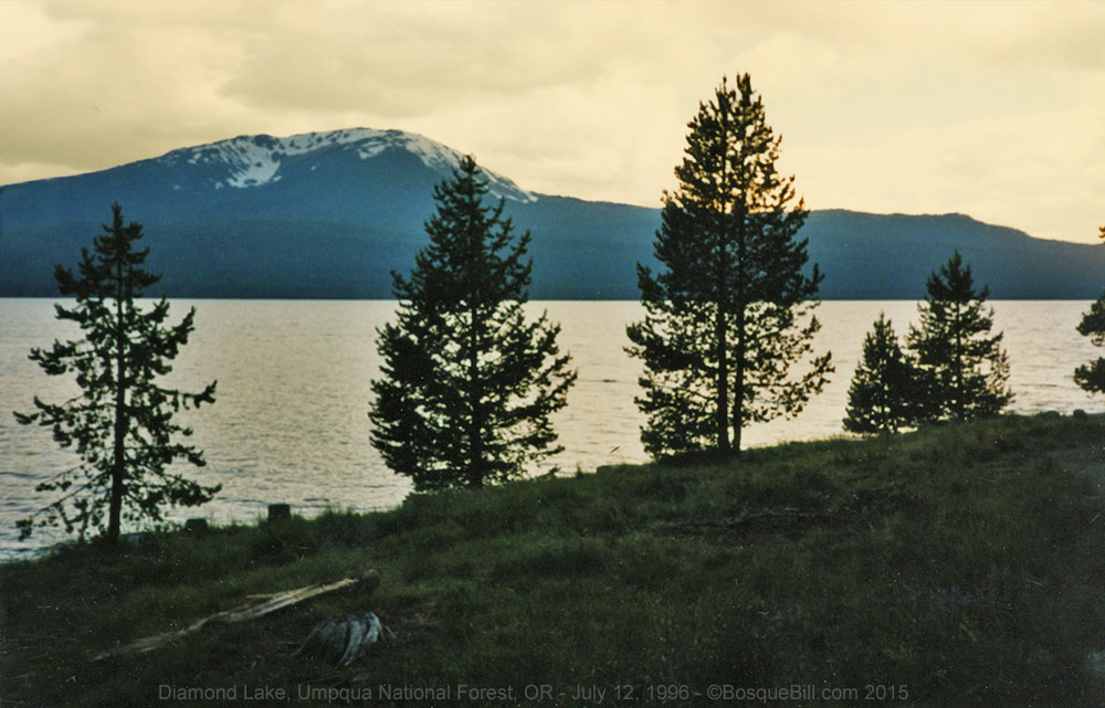 |
| Evening at Diamond Lake with Mt. Bailey in the background. |
Saturday, July 13
I rode back to US97 in order to head to Bend, Oregon. As I rode north on the highway I could see the string of volcanic created mountains to my left, one snow capped peak after another. I finally could see and fully realize the origins of the Cascades as I recalled the story of the hot spot under the earth's mantle moving underneath over the eons. Along this route were road signs announcing the scenic and recreational opportunities off the main highway, which was itself unremarkable, except for glimpse of a tremendous lava flow just south of Bend. The town itself appeared to be more of a staging area for the surrounding opportunities rather than a final destination.
From there I turned on to US20 toward the town of Sisters where I planned to have lunch with a view of the Three Sisters volcanic peaks. Traffic came to a halt outside of town. It turns out that that week-end was a quilting festival and the crowds were large, totally clogging the town, so I passed it by. Up ahead was another volcanic peak, but it was shrouded by a hazy cloud. It was Mt. Jefferson and the cloud was the result of a forest fire.
I took State Route 22 past the peak Three Fingered Jack and headed down the Santiam River valley toward Salem. It was now very hot and in Salem I stopped to cool off with a milkshake and drenched my T-shirt to air condition my suit. The ride up I5 was predictably boring and hot until I got into the Portland area where it was only slightly cooler. I headed out to the northwest edge of the city to my friends' house in the countryside.
Sunday, July 14, through Sunday, July 21
 |
| Vista House perched on Crown Point, just east of Portland, above the mighty Columbia River. |
 |
| The Columbia River - looking east from Vista House |
 |
| The Columbia River - looking west from Vista House toward Portland. |
I had a great visit with my friends Ralph and Betty, formerly living in San Jose. They have a lovely home on 12 acres just outside Portland. Their back deck overlooks fields and forests. While visiting with them I was shown some of the interesting and scenic neighborhoods of Portland, both residential and commercial. I relaxed with a novel and went to a movie (the above mentioned Phenomenom) during two days of typical Northwest rains. Most evenings we would relax in their indoor pool with good wine and hors d'oeuvres.
 |
| My friends' house with my motorcycle parked & covered out front. |
 |
| A view of the back of the house with the Husky pup helping me look for birds. |
 |
| Relaxing on the back deck. |
I took a day-trip on my motorcycle a little ways up into Washington to see Mt. St. Helens. Nothing prepared me for the extent of the devastation as I slowly approached the volcano. The surrounding forests have been replanted by the timber companies, but the areas closest to the peak have been left to nature's course. I was lucky enough to be there when the wild flowers were in full bloom; the hillsides between the fallen trees were thick with color.
 |
| Mount St. Helens - 3 photo panorama taken from the deck of the visitor center on Coldwater Ridge. Click for a larger version |
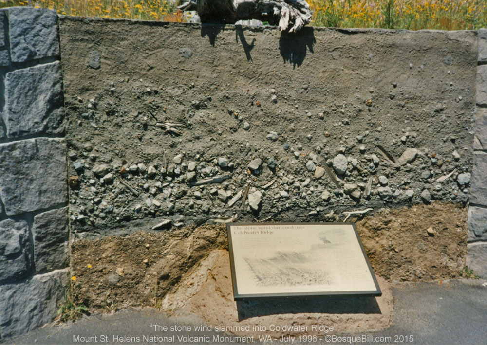 |
| "The stone wind slammed into Coldwater Ridge" Preserved cut into the ridge showing before and after. |
 |
| Mount St. Helens |
 |
| Mount St. Helens as seen from below Coldwater Lake. |
Betty took me sightseeing up the Columbia River Gorge on the old scenic highway. We visited the famous Multnomah Falls, but I especially enjoyed the beauty and solitude of two smaller falls, the cascades of Wahkeena Falls and the vertical drop of Latourell Falls. There are seven major falls and many interesting trails in the gorge area. Saturday I helped Ralph nearly finish his shake-shingle roof over the enclosed swimming pool addition.
 |
| Latourell Falls |
 |
| Multnomah Falls Click for a larger version |
Sunday we all drove out to spectacular Mt. Hood, which is visible on clear days from Portland. We had a really good lunch at historic Timberline Lodge on Mt. Hood, built by hand by artisans of the WPA. We watched the snowboarders and skiers on the slope above the lodge. There are more skiers and 'boarders during the summer months than during the winter according to a forest ranger there. If you visit Mt. Hood you have to stop in the lodge and admire the scale and craftsmanship of its creation.
 |
| Mount Hood |
 |
| Timberline Lodge |
Monday, July 22
 |
| Headed downriver toward the Pacific Coast |
 |
| Wildlife refuge along the Columbia River |
I resumed my journey by traveling down along the Columbia River on US30 toward Astoria. I was able to see Mt. St. Helens in the background as I rode first north then west. I took a short side trip to an eagle reserve, but didn't see any eagles (during the middle of the day). I joined US101 after a quick stop at the marine museum to travel south along the Oregon coast.
 |
| The historic Lightship Columbia at the maritime museum in Astoria. |
 |
| Home port of the USCGC Steadfast. The Astoria Bridge can be seen in the background. |
My plan was to both revisit the places and route of my bicycle tour from Seattle to SF four years ago and to see areas that we skipped as they were impractical to ride to with a fully loaded bicycle. First, I stopped in Seaside to see a typical beach resort town. Then enjoyed the coastal views to Tillamook where a visit to the cheese factory is considered essential. While there I picked up provisions for the night and turned off the highway in favor of the Three Capes Scenic Route. We had skipped this when bicycling, as it had a reputation of being extremely steep and tough, but we missed some wonderful views.
 |
| Tillamook Cheese factory - my favorite cheese to this day. |
 |
| Lighthouse at Cape Mears. |
I stopped for the night at Cape Lookout State Park which was excellent. The campground is at the foot of Netarts Bay amongst the pines and firs. It is very close to a expansive sandy ocean beach, but is protected from the wind by a long grass and shrub covered dune which must have been well over 30 feet tall. There was a colorful sunset which I hope I captured on film.
 |
| My campsite at Cape Lookout State Park. |
 |
| The beach at Cape Lookout. |
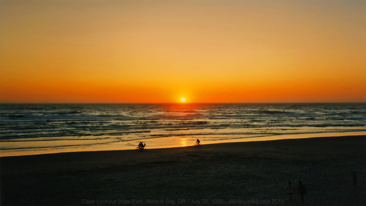 |
| Gorgeous sunset at Cape Lookout. Yes, those are folks riding their bicycles along the waterline. |
Tuesday, July 23
 |
| Looking north from Cape Lookout |
 |
| Fog along the Oregon Coastline |
I resumed the scenic route which later rejoined south 101. South of Lincoln City I took the Otter Crest Loop, another scenic alternate route along the cliff tops which drop to the sea. The fog which had been absent for days was starting to make its return and I had to put on a wool shirt under my riding suit. I much preferred this to riding in the heat, however. I stopped to see the Yaquina Head Lighthouse and Newport harbor both of which had been skipped on the bike tour. The Cape Perpetua area south of Yachats was spectacular and there were a number of beautiful little campgrounds I would like to stay in on future trips.
 |
| Yaquina Head Lighthouse, in a field of wildflowers, is the tallest on the Oregon Coast. |
Farther south I skipped the Seven Devils Road, which we had biked, in order to see what the town of Coos Bay was like. There are a lot of timber companies there, at least that is all that can be seen from the highway. At Bandon I turned off to look at the Coquille River Lighthouse. It was extremely foggy now and I had to keep wiping off my visor in order to see. Back on the highway, US101 now runs a few miles inland and I made good time on the straight and fog-free highway. I did pause south of Bandon at the roadside stand of Misty Meadows Farm for a jar of wild huckleberry jam (Mmmm!) At Port Orford I stopped for dinner and provisions in preparation to spend the night at the Humbug Mountain State Park campground. This was a pretty place where I camped near a babbling brook. It was about a mile from the ocean and the sun was shinning here, at least until the horizon rose.
 |
| The Coquille River Lighthouse is not very tall. |
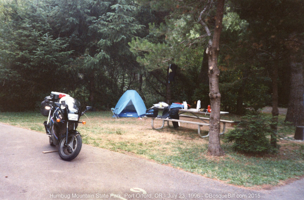 |
| My campsite at Humbug Mountain State Park |
Wednesday, July 24
[There are fewer photos from this point in my trip. I guess my thinking was that I had plenty of photos of these areas from previous trips. My thinking now is that this was short-sighted of me.]
The day started foggy and as I rode south it was chilly indeed. I finally had to stop and pull out my winter gloves to keep my hands warm. There wasn't much to see due to the fog, just ghostly indications offshore of jagged rocky isles covered with trees. I quickly made my way past Gold Beach and Brookings, and found myself crossing into California.
South of Crescent City 101 climbs up into the redwoods. The alternating fog and sun between the trees was enchanting. After crossing the Klamath River bridge with its gold grizzly bear statue guardians I took another scenic alternate route. While stopped to admire a herd of elk feeding in a meadow near the road, I was able to watch fledgling barn swallows sitting on a split rail fence. Their parents were bringing them fresh caught insects and were able to place the bugs in the waiting mouths without even having to land - talk about fast food!
After Eureka the highway turns significantly inland passing through more lumber mill areas. Thousands of dead redwood trees are stacked beside the road. Then comes the Eel River and the turn-off for the Avenue of the Giants. This is the old two lane highway which winds beneath the giant redwoods. It is a fabulous area. I stopped to pick ripe blackberries to have with my picnic lunch, which I enjoyed under the giant trees within view of the river.
 |
| California Redwood. |
As I proceeded south the temperature got warmer and then hotter. By the time I passed Garberville it must have been 100 degrees. I stopped to engage the "air conditioning" of my suit. I was then caught in a big traffic jam back on the 101 due to road repair, what a drag. State Route 1 begins at Leggett where I pulled off for dinner and to cool off before heading back toward the coast. The two lane highway over to the coast was great fun on the motorcycle and within an hour I was relieved to be back in the cool fog zone. I continued then down the coast past Ft. Bragg, one of my favorite little towns, to stop at Van Damme State Park campground a few miles past Mendocino.
Thursday, July 25th
 |
| Campsite at Van Damme State Park, CA |
I arose and performed a little bike maintenance in the fog and started out for home. This was an enjoyable area to ride. I am familiar enough with it that I could allow myself a little more speed on the bike and had a great time. For those who have not traveled the northern California coast I doubt I could adequately describe the beauty of the edge of the continent. Imagine rocky crags, coastal chaparral, the sapphire blue of the sea contrasting with the white foam where it crashes on the rocks, the cypress and other evergreen trees, the wildflowers, and the sky all seen from various angles as the highway twists and turns, rises and falls.
At Bodega Bay I decided to brave the inland heat in order to join the 101 freeway to get through Marin and San Francisco counties before the worst of the afternoon commute. The heat didn't last long as the fog was advancing well inland by San Rafael. Since you are reading this I obviously made it home safe and sound. My house was still here and the yard looked nice thanks to my good neighbors who I rewarded with some of that great huckleberry jam.
Bird species seen at Ralph & Betty's in Portland:
Oregon Junco (most prevalent species)
House Finch
American Goldfinch
Song Sparrow
American Robin
Pacific Slope Flycatcher (ID by song only)
Black-capped Chickadee
Violet-green Swallow (nesting in roof vents)
Winter Wren
Rufous-sided Towhee [now named, Spotted Towhee]
Hermit Thrush
Western Tanager
Band-tailed Pigeon
Northern Oriole (Baltimore var.)
American Crow
[Thanks for reading and I hope you enjoyed this journey through time as well as space.]
It is wonderful to revisit past trips!
ReplyDeleteIt is, isn't it? I just flipped through these photos again - what a trip! Even since writing this post I'd forgotten about all the cool places.
DeleteThanks, Ski.