Friday, June 20, 2014

SW Colorado - June 2014 - Part 2

Here is the second part of two.

Wednesday, June 4, 2014 (continued)


Montrose


After leaving Black Canyon NP, I headed into the small city of Montrose and got directions to the ranger station - it is a combined federal facility south on US-550 toward Ouray. I was curious about an area west of there I'd never explored. I had originally intended to drive down US-550 through Ouray, Silverton, etc., but the folks at the NFS office in Pagosa Springs had let me know the road over Red Mountain Pass was closed (except for one hour at noon.) Rather than try to hit that seemingly arbitrary window, I decided this was a good opportunity to go somewhere new.

The ranger at Montrose was extremely friendly and helpful. She explained that Red Mountain Pass was not closed due to snow, rather the highway department was working every day to bring down loose slabs of rock above the highway. You could get through during non-working hours. Still, I thought visiting a new area would be fun.

She had a wealth of information on the area west of Montrose that I was interested in visiting. It's called the Uncompaghre Plateau, and her directions on how to get there were impeccable. Her suggestion was to take CO-90 out of Montrose, then she detailed where I needed to bear right to then follow the Divide Road up the spine of the plateau. When asked about the vegetation, as I had no idea what to expect, she said it was forested with aspen and conifers. She pointed out the available campgrounds and mentioned where dispersed camping might be found. All right. I bought the NFS map and set out.

CO-90 leaves Montrose in a series of right-angle turns in a southeasterly direction, once out of town it dives into and out of a canyon, then climbs up toward the top of the plateau. Once on top and before entering the forest the views to the south were spectacular.

View of the San Juan Mountains as I reach the top of Uncompaghre Plateau

Uncompaghre Plateau


The Uncompagre Plateau is indeed forested and as the name implies relatively flat, though naturally lots of canyons along the margins. The elevation is between nine and ten thousand feet. There are many side roads and even ATV trails. I was told the area was popular with that group, but I only saw one such vehicle when I was there mid-week.

The Divide Road bisects the southern portion of the plateau. Columbine Pass is not quite halfway up and is a pass from east to west, between the towns of Delta and Naturita. Just north of the pass is the free Columbine Campground operated by the NFS. The campground is an ATV paradise. I'm guessing it was an old gravel pit or something. There is a "training" track in one pit and a small lake or pond in two others. The campsites are large, level and each has a sign designating the number of vehicles for that site.

I had driven through to check it out, as most of the side roads I'd looked at for camping were still muddy messes from snow melt. Although it was quiet with only one group this day, it wasn't particularly attractive to me either, so made the decision to drive on. I turned back north on the Divide Road and almost right away I saw the post for an old-style NFS sign, but no sign, and a turn off on the opposite side of the road from the big campground. I pulled in to discover what must have been the old Columbine Campground. It was charming, small and nestled under tall evergreens. There were small shrubs, aspen, and lots of wildflowers all around.

My campsite, before I popped the top.

I picked one of the half-dozen sites and set up. There was an enclosed trailer, like would carry a small ATV, in another site. I thought someone would show up later to camp, but no one did while I was there. I spent a lovely, quiet evening there.

Sunset silhouette.

Thursday 


It was a beautiful morning and I decided to walk around and photograph some of the many wildflowers I'd noticed the night before. There were no trails, so I just wandered around the area near where I camped. The ground was nearly hidden by all the leaves and stalks pushing up into the sunlight.

A blanket of buttercups.

An interesting circle of immature Pinedrops

I was delighted to discover this tiny orchid.

I found two of the Calypso Orchids this morning!

As many flowers as there were, that was only a tiny fraction of what would be on display in a few weeks, I believe. I kept trying to watch where I stepped so as to not trample those soon-to-be-flowers, but then relaxed as I realized there were literally thousands of those and only one of me. An amazing place that will be even more amazing in a week or two.

Glacier Lillys were everywhere in large numbers.

A Snowshoe Hare at the morning buffet.

After breaking camp I continued north (actually NW) on the Divide Road. I looked back at the entrance to where I camped and noticed the sign "Columbine Picnic Area"; oops, well, I don't think anyone would care as those were obviously campsites. As there was no toilet, perhaps it had to be called a picnic area.

You may have noticed I cannot resist photographing these stacked-log fences.

Along the divide road, there were a number of miles of forest with large areas of aspen. Then suddenly the road comes to the southwest edge of the plateau and wow, I nearly laughed out loud in delight at the sight before me! The view all along the next stretch of the Divide Road is amazing as it travels along the edge for many miles. What an unexpected pleasure to find while exploring new territory.

Panorama from along the Divide Road.
Remember to click for larger image.

Dandelions and Larkspur

I was guessing that the mountains I could see to the far southeast were the San Juan's, but didn't know what the large mountains were almost due west. I looked at my map and was surprised, then amazed to discover that they were the La Sal Mountains in Utah. Another "wow" moment as I realized I was on the far side of those only a month before when I was at Canyonlands and Arches NP. What a great perspective.

La Sal Mountains, Utah

At the far end of the plateau the road turns northeasterly and enters the Dominguez-Uncompagre Escalante area and then dives steeply down into the valley. CO-141 winds down that large green valley. I should have taken more photos. I did stop at a turn-off after passing an enormous rock outcrop.

Thimble Rock

Unaweep Tabeguache


One of the few spots to pull off the road.

Unaweep Tabeguache Byway is the name given to this drive down 141 and then 145 as far as Placerville. At the town of Gateway the character of the land changes dramatically. From a wide open verdant valley it becomes the steep, rock canyon of Delores River. The sandstone cliffs lining this narrow canyon are as awesome as any in those popular places in Utah and the road follows the river as it winds through.

The Hanging Flume above the Dolores River

Explanatory sign.

San Juan Mountains


I continued on 145 past Telluride. I had hoped to take the West Fork above Dunton, as I'd never driven it. I called ahead to the Dolores NFS station. They said it was not open between Dunton and 145 due to subsidence. Consequently I continued down the highway.

Mountain overlook south of Telluride.

I checked to see if my favorite campsite on Scotch Creek was accessible even though that road was also reported as still closed, but someone else beat me to it. I knew from last year the next available site was way up the road so I didn't chance it (there are very few places to turn around.)

I checked the NFS map and it looked like there was a possibility for dispersed camping farther down the highway at Hillside Drive Road (yes, that redundant name is correct). There were two spots just over the one-lane bridge and I took the nicer one.

Campsite just across the Dolores River.

Another view.

I walked up the trail by the creek that empties into the Dolores River at that point, but hadn't put on my hiking boots. So when the trail crossed the creek I retreated. Still, the area where the creek emptied into the Dolores River was interesting and full of birds.

The rarely seen eponymous feature of the Orange-crowned Warbler.

Camp visitor.

Friday


After breakfast I walked up Hillside Drive Road rather than the trail which hadn't exhibited much bird activity the evening before. That was a good decision, as the road overlooked the tops of the conifers as it climbed. Most of my photos didn't turn out too well, but I had lots of fun watching the birds.

Yellow-rumped Warbler male singing for attention.

Rio Lado gently joining the Dolores River.

After my nice walk, I hit the road. I filled the tank in Cortez and headed east for Durango on US-160. It was only Friday and I wanted to spend one more day in the mountains. I thought I'd head back to the Pagosa Springs area and see if I couldn't find that East Fork Road area I'd been told about. Besides, the drive south on US-84 is much prettier than US-550 south of Bloomfield, NM.

My next door neighbors here at home had enthusiastically and strongly recommended that I stop at  Zia Taqueria in Durango (there are two locations.) I did and am I ever glad. The fish tacos were absolutely the best ever!

I continued east on 160 through another new area for me. Once I passed through Pagosa Springs I paid close attention to the road signs and also to the terrain as I figured that would give me the best clue as to where the East Fork of the San Juan River would be. Sure enough I found the road this time and also realized why I missed it before - the sign was on the left side of the highway when I needed to turn right.

East Fork of the San Juan River


I bypassed the NFS campground and headed on up the very rough road. The road is not technically difficult particularly, but very rocky. The first dispersed camping area along the road was full of trailers and families and ATVs and dogs running loose, so I kept going. Past the second bridge over the river began an area where there were more isolated camping spots - some small ones and others suitable for groups.
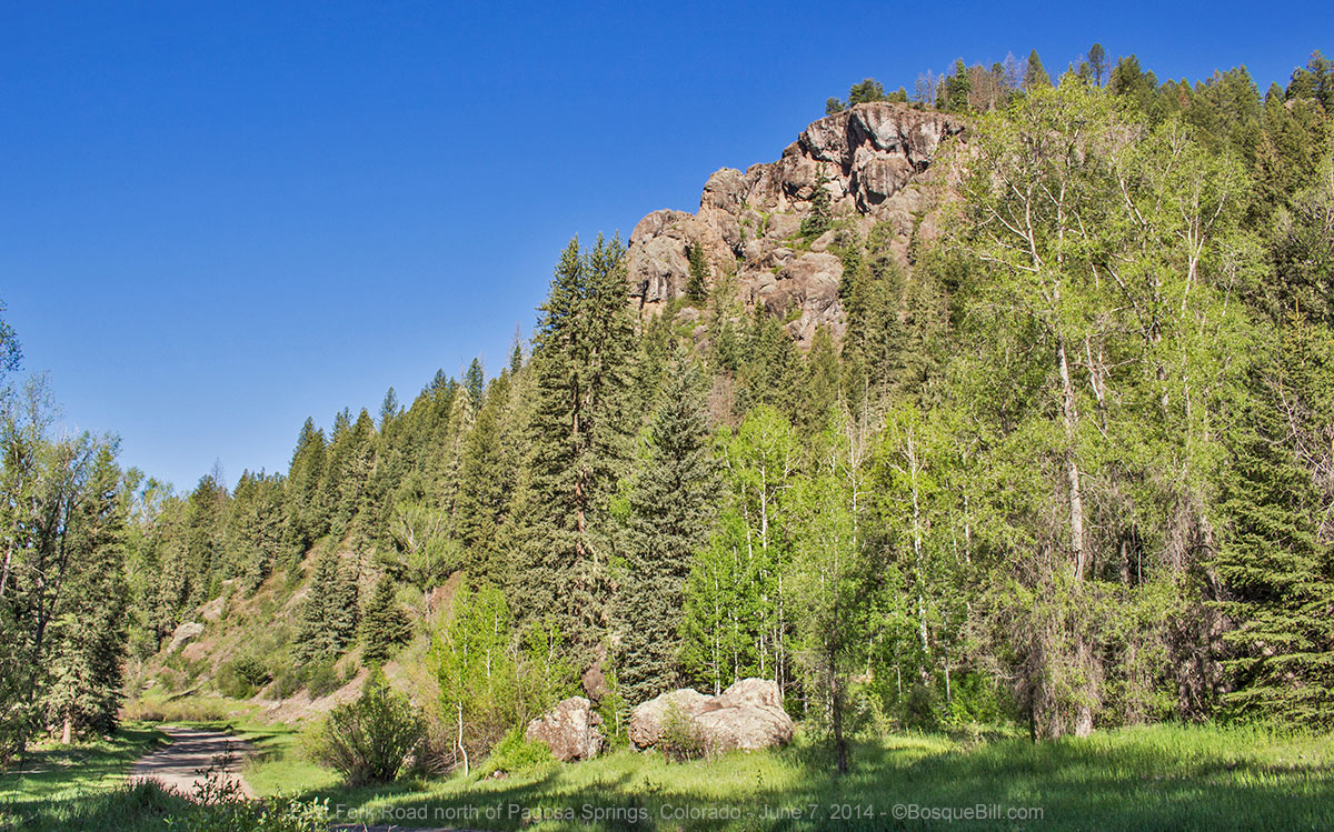
East Fork Road.

This area only runs for a couple of miles before the road enters private land. Although the road continues past the private land, the NFS does not approve that area for dispersed camping.

Campsite. You can just see the East Fork of the San Juan in the background.

I found a nice spot close to the river, yet with lots of shade as it was a very warm afternoon. I changed into my shorts, set my camp chair next to the river, and blissed out admiring the scenery. Though this is a beautiful area, it is heavily used and there were few wildflowers.

The view upstream from my camp chair.

The view downstream from my camp chair.

Saturday


I got a moderately early start for the drive home. I stopped for this last photo just before entering the highway.

San Juan River Valley.

I'd be retracing my steps now back on US-160, then US-84. I stopped for gas and lunch in Española. I discovered Angelina's restaurant (traditional NM style Mexican food) simply by noticing there were lots of cars in the parking lot. Turns out it is very popular with the locals, so it was a good choice.

I completed the trip uneventfully with many fond memories. Here is a reprise of map of my journey.

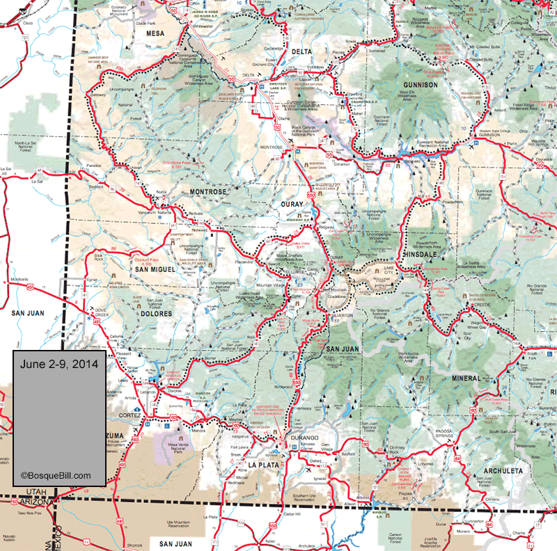
My route for this adventure.


Thanks for reading!

Thursday, June 19, 2014

SW Colorado - June 2014 - Part 1


I'm breaking my trip around Southwestern Colorado from June 2nd to June 7th into two parts for easier reading.

Remember you can click on a photo to bring up larger versions of all photos.

SW Colorado Loop (Parts 1 and 2) - Kindly proceed in the counter-clockwise direction.

Monday, June 2, 2014


Fortified with Little Anita's huevos rancheros, I headed north up I-25, took the bypass around Santa Fe, gassed up in Española and headed north on US-84, left turn at Chama and on to Pagosa Springs.

San Juan River


The San Juan River flows through town and, wow, it was a snow swollen torrent. I stopped at the Forest Service office for maps, brochures, and info. On their recommendation I was going to look for dispersed camping along East Fork Road, which is east of town on US-160.

Through the windshield: San Juan River Valley above Pagosa Springs.

I evidently missed the sign, perhaps distracted by the scene above, as the first place I noticed was the turn for West Fork Road, which I'd noted on the map was farther up the highway than East Fork. I pulled over to check the map and realized I was close to Treasure Falls. The fellow at the ranger station said the trail was steep, but only a quarter mile long. I'd go there first, then decide what to do for camping. Very nice little falls and the trail was as described. You can get right up close to the bottom of the falls if you want to get drenched (which I did not as I didn't think my camera would like that at all.)

Treasure Falls as seen from the highway pull-out.

Closer view of the upper falls.

West Fork of the San Juan River


I turned in on West Fork Road and looked over the official campground. It was nice enough, but I thought I'd check up the road for dispersed opportunities. I found a cool spot right beside the West Fork of the San Juan which was roaring!

My campsite along the West Fork of the San Juan.
Photo taken from the one-lane bridge I crossed to get there.

There were a few mosquitoes, which had me concerned at first, but they turned out not be much of a problem as they were not hungry enough to try and poke through my shirt or pants. There were several other spots for camping past the bridge, FYI, and nice wildflowers in the woods.

Shooting Star Columbine. This species was prevelant almost everywhere I camped this trip.

Tuesday


After leaving my camp and heading back up US-160, I stopped at the scenic overlook.

Looking back (south) toward the West Fork.
The dirt road at the bottom of the photo was the one taken to my campsite.
You may also recognized the rock formation of the first photo above.

I then proceeded up through Wolf Creek Pass and down again. I turned north on CO-149 toward Gunnison at the town of Halfway. The highway along here runs beside the Rio Grande. It is a beautiful area and many folks have built here.

Upper Rio Grande Valley


Looking downstream toward Wagon Wheel Gap

I spotted an interesting forest road climbing a hill, FS 600, so drove up to get a flavor of the land. There were interesting canyon walls and the great views of the valley. I stopped part way up and walked along the ridge.

Looking upstream (westerly) - the Upper Rio Grande Valley.

The highway continues to follow the Rio Grande for quite a ways, then climbs away. This highway is part of the Silver Thread Byway. After crossing a few small passes, I thought I recognized the east side of Red Mountain, between Silverton and Ouray. Sure enough, when I pulled up to the scenic overlook, the signage did in fact identify it as such.

Panorama from the overlook above Lake City

The highway drops down and passes through Lake City which has a "resort" and tourist feel to it. Lake City is also the terminus for two 4WD trails of note, Engineer Pass and Cinnamon Pass. Both connect to the Ouray/Silverton area and are rated "easy" on their east ends and "moderate" to the west.

Following the Lake Fork of the Gunnison River brought me to the long reservoir which is part of the Curecanti NRA. I turned east on US-50 toward Gunnison.

Gunnison Basin


I stopped at the National Forest office and bought a map of the Gunnison Basin area which includes the National Forest and BLM lands there about. The gentleman there didn't have much to add, so I headed over to the BLM office and the young woman there was extremely helpful. She was happy to spend as much time as I needed to explain places to camp, things to see, etc. One of the places I wanted to find was an idyllic campsite up an undeveloped road that I'd found back around 1973 - a gorgeous area with beaver dams and glorious scenery. From my ancient description of the road I thought I'd taken, she gave me her best guess on where I should look, so I headed north on CO-135 to Crested Butte.

Through the windshield: Crested Butte
I passed through the town, which is known for its ski resort, and headed up the road she suggested, 734. It was quickly apparent this was not the area I'd been in before, but the scenery was spectacular and I drove on.

View from Slate River Road

There were a few dispersed campsites way up the road, once you get past the private land. There was also a BLM campground, "Oh Be Joyful". There were a couple of undeveloped roads that turned west, but you needed to ford the Slate River to get to those - not advisable with the river roaring from snow melt. I decided not to camp up there, both as it was still early in the day and at that high elevation, well over 10,000 feet, I bet it would get very cold at night.

Alpine wildflowers

So, I reversed course, passed back through Crested Butte, then took Jack's Cabin Cutoff road to the Taylor River and drove up CO-742 toward Taylor Park. This is a beautiful highway with many campgrounds along the river, but no dispersed camping until you are past the lake.

Taylor Park


Once I was at the Taylor Reservoir I took 55, then 752 to look for dispersed camping. These backroads were slow going and I couldn't find a spot that pleased me. Seems to be an area popular with hunters and the ATV crowd. By the time I wound my way back down and out to the highway I was tired and frustrated and it was getting to be late in the day.

I saw from the map there was a campground at the north end of the lake. I told myself if I didn't find a dispersed spot before I got there I would pay for the campground. I didn't, so I pulled into the USFS River's End Campground. There were only a few people there, so was able to find a spot off to myself and tired as I was, it was nice to have a level spot with no prep needed. It turned out to be a beautiful evening and I took a number of photos.

My campsite with Taylor Reservoir in the background.

My campsite looking at the view in the other direction.
Taylor Reservoir later in the evening.

And again at sunset.

One of the things I'd wanted to try this trip was star photography, so even though I was close to exhaustion, I got out my tripod once it got good and dark. It was windy and very cold. I had some issues with the camera that only another photographer would understand, so won't go into those. Let's say I gave it my best shot and crossed my fingers that when I got home and put the images on the computer, something would turn out. I took a series of 30 second exposures in the hope to stack them to create star trails.

Starry night above the Sawatch Range. One exposure.

My photo sequence didn't come out as well as I hoped, so used Photoshop
and one exposure to create this fun star trails image.
It is post processed, but based upon the actual stars photographed that night.

Wednesday


It felt like it got cold overnight, but when I went to check my wireless indoor/outdoor thermometer I discovered the outdoor transponder's battery had died during the night. When the campground host came around in the morning (the fee deposit slot had been taped shut when I came in) she said it had gotten down to 20 degrees overnight. That explained the ice in my grey water bucket!

Taylor River Valley


After breaking camp I continued north up 742, the Taylor River Road. There are a few residences within the first half mile of the campground, then the road is within the Gunnison National Forest, and in another half mile there is a side road leading toward the river where there is dispersed camping. And then another side road and another. Lots and lots of beautiful campsites, not right on the river as the regulations are that there is no camping within 100' of the river, though at some sites those feet are pretty small.

I started to feel foolish for staying in the campground the night before, but then I realized that I'd gotten my $7 worth (discounted fee) simply in my conversation with the campground host who gave me the weather report, told me about the four moose that had been seen a couple of times in the willows near the junction to Cottonwood Pass, about the herds of elk frequently seen in the valley, and confirmation of road conditions (Spring Creek Rd was closed due to rock slides in two places, so I would not be able to loop back toward Gunnison via that route, but backtrack instead). Plus, I now realize I got lots of photos that I like from that spot, too. A bargain.

Taylor River Valley

The Taylor River Valley is quite lovely and certainly scenic. There is grass and willows along the river, but the valley floor is mostly brush. The conifers march down from the shoulders of the mountains, but stay along the valley margins for the most part. The mountain peaks were still snow covered and provided a grand background to the scene. Those peaks are of the Sawatch Mountain Range and the Continental Divide runs along their crests.

More alpine wildflowers.

As I drove up the valley I was surprised I didn't see anyone fishing in the river. Perhaps it is just too early what with the river swollen with snow melt. There were a couple of "pot hole" lakes up the valley and I spotted one fisherman there.

There are a couple of official campgrounds along the route, for those who want those amenities. I continued up the road until I reached the old Dorchester Cabin - all that's left of the town of Dorchester.

Dorchester Cabin.

I returned the way I came, stopping at the scenic overlook at the lake.

The Sawatch Range reflected in Taylor Reservoir.

I returned to Gunnison. While getting gas I asked a fellow patron where a good place for lunch could be found. She said the Gunny Sack on N. Main Street was her favorite, but you couldn't really go wrong at any of the places in the first two blocks north of Tomichi (US-50.) I tried her favorite and ordered one of their specialty burgers and was very pleased and very full.

After lunch I headed west on US-50 with a destination of the Black Canyon of the Gunnison National Park. A photographer friend of mine said the Black Canyon was a spectacular place, but he'd never found a way to photograph it to do it justice.

Crazy drive that afternoon. Lots of freeze damage to the highway and some trucks carrying humongous tanks that took up two lanes. I thought I'd missed the turn-off to the park, but it is just much closer to Montrose than I'd thought.

Black Canyon of the Gunnison National Park


I checked out the campground at Black Canyon, though it was still too early to camp. It was pretty nice. There is vegetation screening many of the sites from one another, especially in the non-reservation, Loop C. Not a bad place to camp if your itinerary places you there late in the day.

Black Canyon was indeed amazing and these photos don't do it justice.

Looking upstream from near the Visitor Center

Look carefully - you can see the river along the canyon bottom.
The light didn't provide enough contrast to make it easy to understand you're looking
down the canyon, and not simply at the canyon wall on the other side.

Looking downstream toward the end of the canyon and Montrose.

The rock at the bottom of the photo is at my feet.
The rest are way, way down.

Obligatory wildflower photo from along the canyon rim.

End of Part 1 of 2