Saturday, July 13, 2013

San Juan Mountains Camping

This is the fifth and final post covering my trip to the San Juan Mountains of June 11 - 16, 2013. This installment may not have the same excitement factor as some of my earlier posts, but I hope you at least enjoy the photos.

June 15, 2013

After my quick survey of Ophir I headed south on US-550 to check out the area around Trout Lake and Priest Lake to see what I might find of interest and what might be available for dispersed camping. (I only later learned there were some old "ghost town" type ruins around Ophir which I totally missed, so may have to get back to see those.)

I looked for the north end of Priest Lake Road, but it was apparently unmarked and hidden, so couldn't find it. I turned onto Trout Lake Road a bit farther south. Trout Lake is pretty good sized, surrounded by many summer homes, and the level was very low. It didn't seem like an attractive site for photographs. There was a cool old railroad water tower along the road, but again didn't strike me as attractive. Oh, I could have taken an image, then manipulated the surroundings to make it more appealing, but why bother. I later learned the tank was left from the days of steam powered rail travel in these parts.

Where the road crosses the creek that feeds the lake, there was an old rail trestle from that earlier era that was situated in a prettier area for photography.

This creek flows from Hope Lake to Trout Lake and then into the San Miguel River.
If you then turn around to look downstream from this point you will see the trestle.

Narrow Gauge Railroad Trestle
Here is another view from the ridge above which gives a better idea of its structure.

Narrow Gauge Railroad Trestle

I didn't explore farther up this road as it looked like it headed right back to US-550. Instead I turned around and drove a little ways back toward Trout Lake and took the turn-off called Hope Lake Road. The road does not go to Hope Lake, but to the trailhead of a hiking trail leading to the lake. The road climbed a ridge, then I passed a couple of dispersed campsites, one which was occupied. I knew the road ended at a locked gate, so when it got too rough, I turned around to check out the last campsite I'd spotted. (Again, folks from Colorado seemed to have no trouble driving their small passenger cars up the road I thought too rough. Guess I didn't have the right attitude!)

As it happens that was a very nice and level site in tall trees on a ridge overlooking a beautiful valley. There was a rock fire ring and a great place to set up my camp chair to admire the view. I decided to call this good and set up camp even though it was still early in the afternoon, besides I needed a little time to just sit and relax as I'd been going and doing all week long.

Campsite just off Hope Lake Road.

It was a nice level spot with a fantastic view.

When I first looked at the photos of the valley, below, that I took from my camp chair, I was seeing through the eyes of my memories as much as anything. Now, when I look at these photos I realize they don't convey a fraction of the magnificence of the view. The area containing the fire ring and my chair are on top of a grass and flower covered hill. The meadow with a small pond is several hundred feet below. The valley is wide and long. I was able to sit comfortably, contemplating the mountains around me: Sheep Mountain, San Miguel Peak and Vermillion Peak. I could gaze at the mountainsides with my binoculars taking note of the rock formations and vegetation, the evidence of avalanches and rock slides, and observe the age of the trees now growing in those scars. I watched runnels of melting snow cascade down narrow clefts and the play of the clouds in the sky. All around birds were singing, though they chose not to present themselves to my camera.

Here's the view from where I set up my chair to watch the weather.
I realize now it is hard to tell from the photo that this spot is on the top of a hill.

After sitting and admiring the view for a while, I got out my macro lens. There were lots of flowers around camp and down the hillside.

Jacob's Ladder (macro photograph)

 The spruce trees were pollinating like copiously - that's what the little yellow spheres are on these and the following flowers. When I would hear a wind gust come through, I'd look up to see large clouds of pollen fly from the trees. I thought it was dust, at first, until I figured it out. I was sneezing like crazy, but what was worse was when the pollen got under my contact lenses - ouch!

Wooly Cinquefoil. It took me a while to ID this plant as most varieties of the species have only 5 petals. (macro photograph)

Wild Strawberry (macro photograph)

Dwarf Chiming Bells that haven't yet opened, but I love the organic flow of the plant which formed itself into the shape Leonardo called the Golden Spiral. (macro photograph)

Teeny-tiny Whiplash Daisies (macro photograph)

Sublime White Pea Vine blossoms. (macro photograph)

It was getting toward evening, so I started a small campfire to keep me company as I drank in the view. Speaking of drinking, you might see in the photo my small mason jar of Jack Daniels and bottled water chaser... purely for medicinal purposes, you understand.

Sheep Mountain
Close to dark a small group of deer ventured out to graze in the meadow, but there was not enough light then for photos.

Sheep Mountain lit by the last rays of the day's sun.

Successful experiment in campfire photography, IMHO.

June 16, 2013

The next morning dawned clear with only a few puffy clouds.

Sheep Mountain in the morning sun.

I decided I'd declare the trip a big success and start back home later in the day. First, I wanted to walk around a bit and check out the meadow below.

A Western Wood-Peewee was fly catching from this branch of a fallen tree.

Marsh Marigold found, naturally, in a shaded, marshy area.

Dark-eyed Junco

A Pine Squirrel who insisted on keeping between me and the sun which made a challenge for photography.

I did make it down to the meadow, which turned out to be pretty marshy. I also followed a tiny stream up to some attractive mini-cascades, but for some reason didn't take any photos - maybe I was stuck in the flower/wildlife mode. I took a few short videos of the babbling brook, but those are too shaky to share, even after applying post-process stabilization.

After my walk, I packed up and negotiated back down the forest road. I did find the south end of Priest Lake Road and drove up to see what was there. I found several dispersed camping spots and the small lake. The north end of the road was not only unmarked, but came out next to someone's house which made it look like a private drive. Hmm, wonder if the people in the house took down the sign so there wouldn't be as much traffic by their yard - not accusing anyone of anything, but if I lived there, the thought would have occurred to me. I stopped to check out a couple of other places for possible future explorations, but didn't find anything worth reporting here. And then through Dolores, Durango and back to New Mexico.

Thanks for following along on my latest camping trip to Colorado. I hope you found a thing or two of interest. I haven't made any plans for my next trip, but will come back up to Colorado before too long, perhaps venturing a bit farther north. Also, the mountains in northern New Mexico have seen some rain the last couple of weeks and the authorities have begun opening some of the forests and public lands, again. So that is another possibility.

Thursday, July 11, 2013

Telluride Colorado Environs

This is the fourth of five posts covering my trip to the San Juan Mountains of June 11 - 16, 2013. I figured smaller chunks would be more digestible.

After completing the length of the Last Dollar Road, in the last installment, I wanted to spend a little time around the Telluride area. Plus, I wanted to scoot up the highway late that afternoon to take photos of the beautiful scenery around the Last Dollar Ranch with blue skys, so camping somewhere near Telluride made sense logistically.

June 14, 2013

This post is called "Telluride Coloroado Environs" because it will cover some of the areas around and near the town of Telluride, but not the town itself.

I wanted to take a look at the end of the box canyon where the town is situated. There was a tall waterfall that looked interesting and I had come to learn that the road from Black Bear Pass terminated there, too. So, I drove through town and up the road where I found an overlook to see those things and the Pandora Mine, as well.

Pandora Mine and the road from Black Bear Pass.
The Black Bear Pass trail is rated difficult and is one way downhill in the trickiest section on the west side.

The sun was all wrong to get a quality photograph, so this is the best I could do this morning. Taken from only a few feet away from the photo above. This whole area is private land.

Bridal Veil Falls
In the photo above, you can see a white building. I used the telephoto to get the next image.

House at the top of the falls

I asked about the building on top from a local mountain biker and got a story built of half-truths and hearsay. Even with a little Internet search I'm not exactly sure what is up there... a house that used to be a powerhouse for the town & a mine and the second oldest AC power generator in the US, is the best I can uncover. However, there is still apparently a hydro-electric power station up there that still supplies some electricity to Telluride.

The oldest AC generating plant in the U.S. is attributed to Telluride, and did indeed send power to the town, but was located at nearby Ophir. This first powerplant was built under the supervision of Nikola Tesla, himself, and paved the way for our modern AC power distribution system. (Thomas Edison promoted his own DC power system, but the success of AC power transmission won the day.)

From here I headed south on highway 145 to check out the Sunshine Campground I'd spotted on my previous trip to the area. I knew if I wanted to get back over to photograph the Last Dollar Road that evening I'd want to find a camp on this side, as it is all private land at the north end of LDR. The NFS campground is small, but situated both close to Telluride and in a spot with a terrific view of Sunshine Mountain. I talked to the host there and he invited me to have my picnic lunch at site #11.

Picnicking at Site #11, Sunshine Campground, Uncompahgre National Forest.

As you can see the view is amazing. As wasn't familiar with any other camping areas nearby, I paid my fee to reserve this very spot, insuring I'd have a place to camp that night if I was late returning from my photography. Clever host getting me hooked on the view.

I drove back north, then west, on highway 145 to check out that area. I drove up Fall Creek Canyon to Woods Lake where there is another NFS campground. The lake is fairly nice and the view was nice, but neither exceptional. There was one dispersed camp site on that road where I stopped for lunch and to relax for a few hours in the shade by the creek. I also drove down the San Miguel River for a few miles. That area is much drier and less wooded being at lower elevation; looks like a popular area for rafting.

Western Tiger Swallowtail

Late that afternoon I drove back to the Last Dollar Road and took lots of photos, a few which I included in my previous blog post, as I've mentioned more than once. I then drove back to the Sunshine Campground for a pleasant evening and night. As you can see from the photo above, my camp site was really just a wide spot in the road with a picnic table and fire ring. I was afraid I'd be disturbed by cars continually driving by, but only one drove past the entire evening, and the view was exceptional.

June 15, 2013

I hung around the camp enjoying the view and taking photos.

A panorama from the scenic trail by my campsite. Click here for a larger version.

Looking up the canyon (southeast) from the trail to show Sheep Mountain in more detail.

This was the view of this great twin Ponderosa from my camp site.

After breaking camp I explored the canyon just below the campground in which the south fork of the San Miguel River flows. There is also a dirt road that runs from highway 145 south of the campground to highway 145 west of Telluride, paralleling the river.

The upper and lower sections of the canyon are private land, but there is a stretch of national forest in the middle. An interesting thing I discovered was that the Galloping Goose trail runs though the canyon. This trail is the former path of the Galloping Goose narrow gauge train from years ago - a strange contraption half truck and half train. The trail is now popular with hikers and mountain bikers.

Here are a few photos from along the river.

I had stopped to check out the Galloping Goose trail where it crossed the river on a modern, steel footbridge when I looked down to spy this bird. Dippers feed underwater (yes, underwater) in fast moving streams and although they are not rare, they're not often seen. It quickly disappeared. I walked across the bridge and down to the river to see if I could see where it went. After a while I made the discovery that it had built a nest under the footbridge and was bringing bugs to its young in the nest. Cool!

American Dipper with a bug to take to the nest.

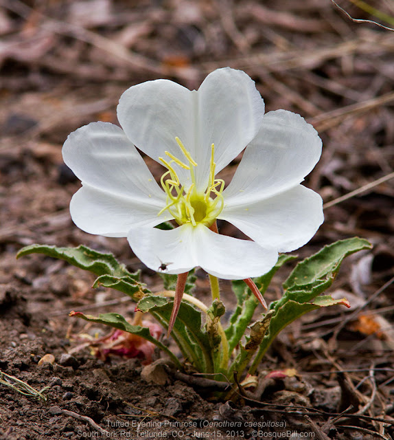
Tufted Evening Primrose - a very small plant.

No, not a chipmunk, but a Golden-mantled Ground Squirrel

Scarlet Gilia, a.k.a., Skyrocket Gilia

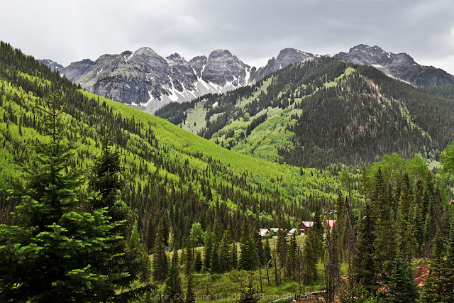
After having lunch along the river, I drove back up the canyon, crossing highway 145 and toward the town of Ophir. Shortly after crossing the highway, I noticed quite a number of cars and trucks parked along the road. When I looked up at the canyon wall, I discovered there were rock climbers clinging to the sheer cliff. Seems this is a popular spot for the sport. Sorry no photos.

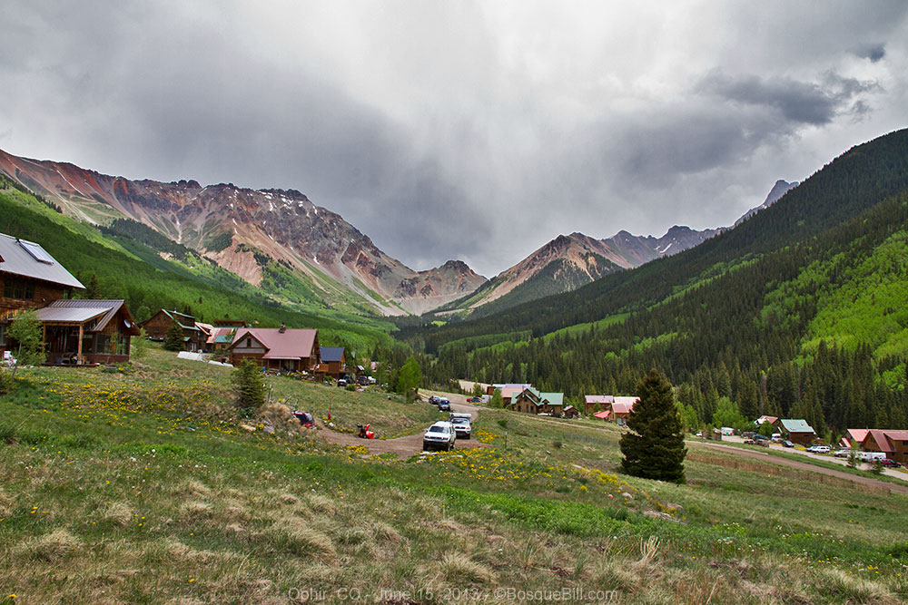
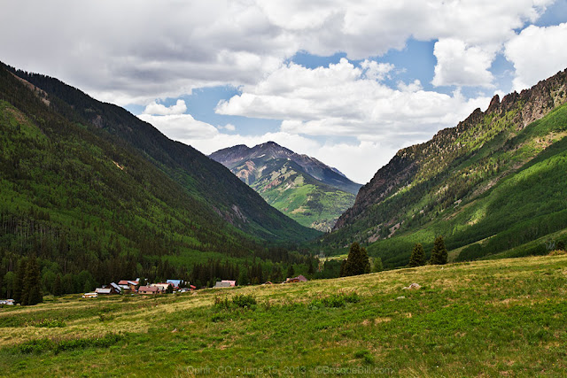
The historic, gold mining town of Ophir is a lovely little community in a beautiful valley. I doubt I'd really enjoy the snow in winter, but if I had half a million dollars laying around my bank account I'd love to get a nice little house with a big deck here and learn to cross-country ski!

Ophir, CO. Looking south.

Ophir, CO. Looking west.

Ophir, CO. Looking east, toward the pass.
Ophir Pass road. Photo shows the challenging section across the talus slope.

From here I drove south on highway 145 to further explore the area and to find a camp for that night. The adventure will be continued in the next installment.

Thanks for reading.

Wednesday, July 10, 2013

Last Dollar Road

This is the third of five posts covering my trip to the San Juan Mountains of June 11 - 16, 2013. I figured smaller chunks would be more digestible.

Regular readers may remember my post, Brief Foray into Colorado, where I attempted to drive the Last Dollar Road from south to north in May of this year. I abandoned the attempt a few miles in after getting a shakey road report from two guys coming down the mountain, since I was still driving on OEM tires. I resolved to try it again once I had good tires installed.

June 13, 2013

In my last installment I'd driven through Ouray after visiting the Red Mountain Mining District. I filled the tank in Ridgway and drove west on highway 62 about 12 miles to the turn-off to the Last Dollar Road. It was late in the afternoon, but the road is reportedly only 21 miles long. My thrown-together plan was to drive past the mostly private lands at the north end of the road and find a dispersed camp site in the Uncompahgre National Forest.

Turning south off the highway, you drive up a small, narrow valley with a marshy stream along the bottom. Look for elk and other critters along the stream and beaver ponds. Several times along that stretch I saw marmots at the road's edge basking in the late afternoon sun.

Had to shoot this out of the window with the telephoto lens as these guys were skittish.


There were also shade-loving flowers along the road.

Beautiful Colorado Columbine flowers

The valley is only a couple of miles long, then you almost magically are deposited into a prairie-like meadow of epic proportions.

The Last Dollar Road runs alongside the Last Dollar Ranch. (View is northerly)

This view was an "ah, ha!" moment for me as I'd nearly forgotten about the very first time I'd ever heard of the Last Dollar Road. I'd seen an amazing landscape photograph, on Google+ I think, that showed a beautiful green field full of wildflowers behind an old, zig-zag wooden fence and a glorious mountain range behind it all. It was simply beautiful and I asked the photographer where it was taken and he replied with the name of this road... and here it was!

Last Dollar Ranch (View is easterly)

And now I have to explain something. The photos above, and the following photos of the flowering fields and sunny scenes below, were not from the June 13th of this trip report's narrative. On the 13th the sky was cloudy and not in a photogenic way. I was astonished at the beauty of the area, but disappointed that the weather was not favorable for photos. So, I resolved to return when the light was better. 

As it worked out, I returned the very next evening from Telluride by taking highways 145 and 62 through Placerville, driving down the Lost Dollar Road as far as the ranch and taking nearly 400 photographs (yes, 400! Be very thankful I'm only putting about 20 before your nose, here) before returning to the Telluride area via the highways just before dark. So the photos are in geographical, not chronological, order. OK ? So let's look at some of these photos.

The yellow flowers in the field are Mule's Ear Daisies, named for the leaf shape.


As I was walking up and down the road taking pictures I heard some movement in a thicket on the other side of the road. Soon I heard a strange "barking" from that direction. It didn't sound like a dog or coyote, so I was puzzled until I spotted this elk in the field keeping a close eye on me and "barking." I'm guessing she had a young calf in the thicket and the barking was a warning for it to keep to cover.

Momma Elk

There were blackbirds keeping an eye on me, too, from the fence tops.

Last Dollar Ranch

Mountain Lupine

A female blackbird keeping her eye on me, too.


American Vetch

One of my favorite photos of the afternoon.


Last Dollar Ranch


OK, let's return to the narrative of that first evening's drive down Last Dollar Road.

As I proceeded south along the road there were turn-offs to other homes and smaller ranches. The road would occasionally dip though a stream or run through a wooded area. Then the road started up into the mountains.

The road climbed and climbed. It was narrow in places, but in good condition. There were no places to turn off until I came to a spot I think of as the westerly overlook. (You can see how unattractive the clouds were that day and it took all my Photoshop skills to pull out any details in the valley below.)

Looking west from the top of the first mountain climb. See the Last Dollar Road below?
I believe that's the San Miguel River valley, with Fall Creek Canyon branching to the left.

The road continued to climb up the hill and finally there was a way to turn off the road on a small track that branched and led into deep forest. I investigated on foot to discover a couple dispersed campsites. I picked one and set-up my camp.


There was only a narrow shelf of level ground before it dropped away. Luckily there was a good sized log I could roll up to the back of the camper, otherwise I'd never have been able to reach the camper steps!


After supper I was feeling very good about how the day had turned out - it had started with a nice walk along South Mineral Creek near Silverton, an interesting drive through the Red Mountain Mining District, a spectacular drive along the high ridge above the Million Dollar Highway, viewing the Gorge at Ouray, then driving down the Last Dollar Road.

Yes, I was feeling pretty smug until I started to hear thunder, until the wind began blowing like the devil, and until the staccato of rain on the roof sounded like firecrackers on the Fourth of July! Suddenly those warning signs posted at both ends of the Last Dollar Road warning that it was impassible when muddy came to mind. It actually didn't rain all that long at this spot, but I kept hearing thunder around the nearby mountains for hours, so had visions of the road becoming a quagmire farther along. Or a tree falling in the wind and squishing me in my bed while I was camped out of sight down a narrow track off the "main" road. Ha, ha, I was telling myself "ghost stories!"

June 14, 2013

Of course the sun rose to clear skies in the morning and other than the dust on my truck now showing a pattern of splotches, there was no indication it had ever rained.

I broke camp and got back on the road. It climbed only about another mile or so before I came to a parking area for the Alder Creek Trail and a few more dispersed campsites. I walked around a little and took photos of the view.

View of the San Miguel Mountains and the Last Dollar Road. Looking southerly.

Last Dollar Mountain. You can see the road coming down the side.
Gray Head Peak on the left with radio towers between them.

The road crosses two talus slopes near the southern end.
The astute reader may recognize this photo is actually from my May trip.

Just past the talus slopes and an aspen grove, there are a few other dispersed campsites perched on the ridge where the road turns and goes down toward Telluride. The view there is fantastic, but probably not recommended when the wind is strong.

Beautiful views even from the lower, southern portion of the Last Dollar Road.

I promised to relate to readers of my earlier post (where I wrote about driving up the Last Dollar Road and then chickening out) about a delicious irony. Turns out I had already driven the rockiest, nastiest portion of the entire road that day in May on my OEM tires!

I'll close out this post with a repeat of the spectacular view of Telluride from near the end of wonderful Last Dollar Road. You owe it to yourself to take this drive!

Telluride as seen from the southern end of the Last Dollar Road.

Thanks for reading. Stay tuned for the next exciting episodes!